With an area of 264,000 acres the Chiquibul National Park is more than
twice the size of Barbados; more than twice the size. The hard part is that
the Friends for Conservation and Development which co manages the park with
the Forestry Department has only eight rangers to patrol the park. And, because
it sits at the western edge of Belize’s territory – the park is
under constant pressure from Guatemalans encroaching upon Belizean territory
– and they go to Chiquibul because it is like any other reserve, a green
forested area – rich with resources – a sharp contrast from the
flat, brown empty lands on the other side of the border.
So while it is a Belizean reserve – when we went there on Saturday
it seemed that it was reserved for Guatemalans! It is the first time any media
house has trekked to this portion of Belizean territory and what we found shocked
us. But before we get there, we begin, on the road.
Jules Vasquez Reporting,
Our journey begins here on the Pine Ridge Road. Executive Director of Friends
for Conservation and Development Rafael Manzanero is at the wheel briefing me
– which I study the map in the back seat. The towering hills and dense,
verdant foliage of the Chiquibul give way to the last wisps of the morning’s
vapor clouds as we pull into the picturesque FCD base at the area known as D’Silva
Camp.
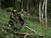
A patrol of 10 BDF soldiers and one police man are waiting for us in a ten
ton truck to be our escort on the journey. The officer in charge of the mission
Lieutenant Justo Velez who goes over the routes on the map with rangers from
the FCD because a strict level of planning and preparation is required because
they will be escorting civilians and the media through the western edge of the 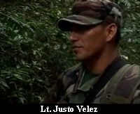 Chiquibul forest – the Caracol Archaeological Park – an area constantly
trafficked by Guatemalan, poachers, Xateros and hunters – all outlaws.
Chiquibul forest – the Caracol Archaeological Park – an area constantly
trafficked by Guatemalan, poachers, Xateros and hunters – all outlaws.
And more than just map-work –Velez also puts us through multiple drills
for the very real possibility of coming under fire. He told us just dive for
cover and his soldiers will do the rest.
Lt. Justo Velez, Commanding Officer
“You all whenever you are in mud, hole, or whatsoever, the faster
you get down the better for you. And we have done this drill, in camp rehearsed
it, and everybody knows what to do. You don’t need to be fearing for your
lives, we will protect you, even if it costs us ours.”
And he wasn’t just giving us a pep talk, Lt. Velez went over multiple
angles, multiple possibilities of attack.
Lt. Justo Velez,
“Quickly we close off the gap so the tubes will be now between the
trek, the media, and the FCD. Any questions? Alright let’s move off now.”
Any thoughts we had of a light hike thru the jungle were thus dispelled and
the fierce clatter of the ten ton truck set the tone adequately. We would be
traveling in this banged up Hilux– it didn’t look like much but 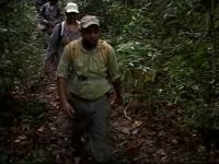 by the end of the day it would show its worth.
Our FCD driver plowed headlong through seemingly impenetrable jungle on old
logging roads under towering forest cover where a branch in the car was like
a bug on the windshield. The truck could only take us two kilometers in to a
drop off point.
The rest would be on foot where we would follow this track to this point 500
meters east of the border – which is that shaded line on the left of your
screen. The square is an illegal plantation within the adjacency zone. An area
for close contact and Velez gave us another briefing.
Lt. Justo Velez,
“If the event we get under contact, we‘ve already rehearsed
that part so just do as you were being told and don’t need panic. You
don’t need to get jumpy. It is the worst things you should ever do when
rounds start to fire.
The discipline then, the tactics, is to be silent but yet be very conscious
and security wise. So when we are moving, we will move tactically at your speed.
So the only noise we should hear is the heart beating by the side of your neck.”
He would hear plenty of that from me on this rugged, often uphill trek–
through paths kept in use by Xateroas and their horses, everywhere the hoof-pocked 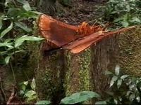 trails told us that the area was much trafficked. Those horses were used for
carrying Xate but also for lugging sawn wood, the product of illegal timber
extraction.
trails told us that the area was much trafficked. Those horses were used for
carrying Xate but also for lugging sawn wood, the product of illegal timber
extraction.
Here, a mere 500 meters into our journey we find a site where Guatemalan poachers
cut down a mahogany tree and portioned it off. Wayne Moore from the Institute
Of Archaeology sizes up– what has happened in an archeological park. The
poachers simply cut out the widest portion of the tree and left the rest to
the forest as if to say, have it we don’t want it. What the group finds
surprising is that these illegal, downright facy operation are moving east,
deeper into Belize – 4 kilometers from the Guatemalan border.
Wayne Moore,
“4 kilometres inside of the national territory.”
All the area on the map are protected under Belize Law – but for the Guatemalan 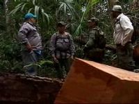 poachers that is the same as no law at all and all along the path heading west
we found similar sites, where trees have simply been cut up – with sharp
chainsaws – which the rangers say you can hear snarling at night.
poachers that is the same as no law at all and all along the path heading west
we found similar sites, where trees have simply been cut up – with sharp
chainsaws – which the rangers say you can hear snarling at night.
We encountered about half a dozen of these sites, all reasonably recent and
all sad. This roughly shorn copper coloured trunk seemed almost to bleed its
protest, and if that wasn’t affront enough, some poacher even etched his
name Anibal in this tree – jungle graffiti– or telling other poachers
it’s his, or just plain idleness. And so many appalling things happening
with trees that in the end, we just shook our heads wearily and kept moving
past – just like the garbage which just lies littering the forest floor.
And that trail of human waste is all over this so-called protected area. This
is an open area in what should be Belize’s pristine forest but it is littered
with Guatemalan garbage.
And then, and then, there’s the looting of Mayan sites. Caracol is an
archeological reserve because it was once among the largest cities and political
centers in Mayan world – and the entire area is covered with Maya mounds
like this one, many of them haven’t even been mapped much less explored.
You see this depression? That’s where raiders tunnelled into this mound.
It’s even more apparent here – the looters dug in past these cut
stones to get into the middle – where they looked for burial sites with
jade and pottery.
Overall it is an assault on the senses – an area that should be pristine,
a protected area – an archeological reserve, has had its resources wantonly
despoiled and exploited in every way – leaving a forest only in name.
It’s left this Doctor of Ecology outraged.
Dr. Colin Young, Chairman Friends for Conservation and Development
“Mad, incredibly frustrated and upsetting to see that this level of 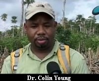 destruction is happening well within our national borders, to see that the forest,
as we walked to get here, is very much fragmented and the logs were being cut.”
destruction is happening well within our national borders, to see that the forest,
as we walked to get here, is very much fragmented and the logs were being cut.”
Rafael Manzanero, Friends for Conservation and Development
“It basically verifies the fact of what we have already seen or reported
in terms of the hacking of the forest that is occurring here along the periphery
of the border. This thing is really a major issue and not only the in the context
of environmentalism but it is really a context where our rules, our regulations,
our laws are stating that any of this thing is illegal to do. So the question
of Guatemalans shouldn’t being able to do it, certainly it prompts another
series of questions of course.”
Dr. Colin Young,
“As an ecologist I think one of the things that is insidious is that
we see a lot of forests and we think that the forest is filled with wildlife
but when we have the kinds of threats that we are getting from the Guatemalans
where they hunt everything; birds, mammals, the macaws, what you will find is
a forest that only has trees and the animals, the peccaries, the jaguars, the
antelopes, all of those animals – in fact we’ve been walking for
a couple hours and I’ve yet to see a single track of some kind of a mammal.
They are not here and I think the reason is why they are not here is that they
have been hunted out. It is an empty forest in the sense that the animals that
play an essential role in dispersal for example and pollination they are just
not here.”
But what is here plentifully is danger. The soldiers and police are constantly
on the defensive, alert and on edge because they don’t know around which
bend in the path they will encounter a Guatemalan with a gun.
Tune in tomorrow night for the last instalment in our Chiquibul series
when we’ll take you to the mission point, the discovery of a Guatemalan
milpa plantation squarely and unapologetically in Belizean territory.
Channel 7


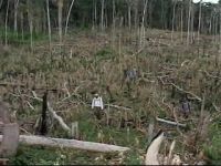
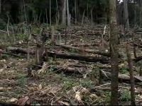 a disgrace, a slice at the western edge of a Belizean protected area, the Caracol
Archaeological Reserve burnt down and cleared slashed and burnt for Guatemalan
milperos.
a disgrace, a slice at the western edge of a Belizean protected area, the Caracol
Archaeological Reserve burnt down and cleared slashed and burnt for Guatemalan
milperos.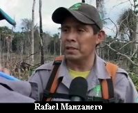 those are everywhere too – and in an act of futile desperation the group
from the FCD uproots some of the shoot.
those are everywhere too – and in an act of futile desperation the group
from the FCD uproots some of the shoot.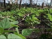 whole farm and in the farm as normal as what we always find, they have pumpkin,
beans, and the corn that they just planted.”
whole farm and in the farm as normal as what we always find, they have pumpkin,
beans, and the corn that they just planted.”
![[Linked Image]](http://www.7newsbelize.com/images/12/121004d.jpg) For the past three nights, we've taken you inside the Chiquibul forest - to show you a place that cameras have never seen before. As we've shown you it is a protected area only in name as Guatemalans use it freely, chopping down trees, hunting animals, harvesting xate, littering and farming. It is a forest under formidable pressure - but what can be done? There are no easy answers in this massive 264 thousand acre expanse - but Jules Vasquez tried to come up with some.
For the past three nights, we've taken you inside the Chiquibul forest - to show you a place that cameras have never seen before. As we've shown you it is a protected area only in name as Guatemalans use it freely, chopping down trees, hunting animals, harvesting xate, littering and farming. It is a forest under formidable pressure - but what can be done? There are no easy answers in this massive 264 thousand acre expanse - but Jules Vasquez tried to come up with some.


