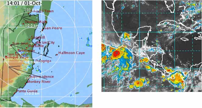
From Belmopan... 09:30 BZT
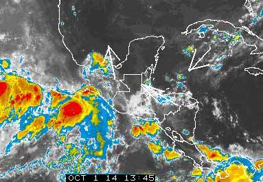
It appears it is NOAA that is having problems, not my computer, so here is their Caribbean satellite picture.
That wet air has moved up rapidly from Honduras, to cause the rain along the Belize coast, which is now rapidly moving inland and NW words as it goes. . .. .Perhaps, when that has spent it activity, we will see better weather later today.
Monthly Weather Summary, September 2014
National Meteorological Service of Belize
The tropical waves came in September 2014 and brought much needed rains to Belize. The first day was cloudy across the country. A tropical wave crossed the country the previous day and its associated moisture and instability produced light rain and thundershowers through to the first day of September. The second of September saw only isolated showers as the tropical wave moved farther west, away from the country.
Between the third and sixth of the month, a tropical wave approached and crossed the country. This was supported by upper-level instability. The entire country experienced showers and thunderstorms.
On the seventh, another tropical wave crossed the country. The accompanying showers and thunderstorms affected mostly northern parts of Belize. Lingering moisture and instability produced a few showers on the eight.
Moisture and instability increased again on the ninth as yet another tropical wave crossed Belize. Much showers and thunderstorms accompanied its passage. This wave was also accompanied by a great amount of moisture and in its wake the following three days saw much showers and periods of rain across the country. On the twelfth and thirteenth, mainly the south of the country experienced some showers and thunderstorms.
The fourteenth saw the passage of another wave. This produced showers and thunderstorms across the country. On the fifteenth and sixteenth, shower activity gradually died down. Between the seventeenth and nineteenth, no special features affected the country. Only isolated showers were observed.
An upper-level trough moved over Belize on the twentieth and sat there for the next three days. This supported showers and thunderstorms around the country, but especially over inland areas. On the twenty-third, a tropical wave added more showers to the already wet conditions.
As the trough and wave moved away from the area, a ridge moved in on the twenty-fourth. This maintained showery weather through to the twenty-fifth. Showery weather was further prolonged on the twenty-sixth as another tropical wave crossed the country.
Showers began to decrease on the twenty-seventh and continued so on the twenty-eight. During this time showers affected mainly the south at night and early morning. This trend continued through to the twenty-ninth. On the last day, a few showers and isolated thunderstorms were observed around the country.
In conclusion, six active tropical waves brought much needed rainfall to the country. These were enhanced by upper-level instability produced by a trough and a ridge. Data collected from around the country shows rainfall amounts were above the average for September at majority of the stations.


![[Linked Image]](http://ambergriscaye.com/forum/uploads/files/usergals/2014/10/full-9930-583-oct_1st_800px.jpg)