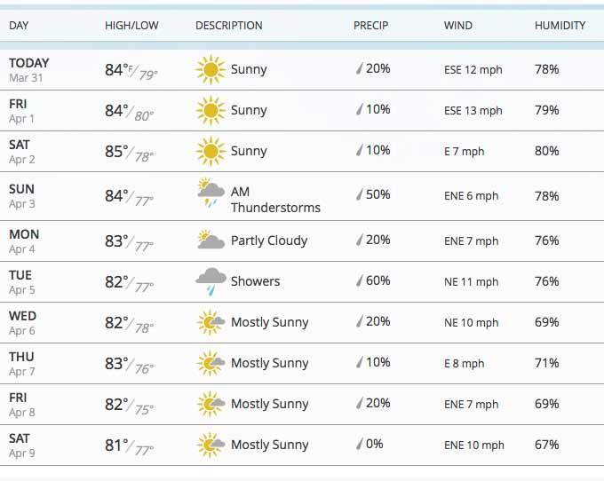
From Belmopan...
Nothing much changing with our weather, the high level from the NNW, Caribbean from the ESE, some small patches of cloud over Belize.
Looks like today will be similar to the last few days, sunny with puffy clouds, no rain.

Today is probably going to be Similar, to yesterday :
Wed, max. 32°C 90°F Last night min. 24°C 74°F ( Coast usually cooler, hills even cooler )
Monthly Weather Summary, March 2016
National Meteorological Service of Belize
Only one cold front crossed the country in March of this year; while rainfall was above normal at some stations in the south and one in the northwest.
The first two days of the month was mainly fair with only isolated showers. A weak surface ridge over the central Gulf of Mexico supported a relatively dry east-northeast airflow over our area. On the 3rd, skies became cloudy and a few showers affected inland areas during the day. Tower Hill and Melinda recorded just under an inch of rain for that day. During the night and the next day, some light rain moving from west to east affected central and northern districts as conditions became moist, especially in the mid levels of the atmosphere. An upper low over northern Mexico produced a divergent southwest upper flow over the region. Pomona received almost three inches of rain, with all other stations well under one inch. A few periods of light rain continued on Saturday 5th, along with an isolated thunderstorm in the Belize City area in the afternoon. The rain gauge at St Johns College recorded just over one inch or rain, while Baldi beacon had about half an inch more. On the 6th, conditions continued relatively moist and a few showers affected mostly southern districts, with Punta Gorda getting about two and a half inches of rain. The rains spread to most areas the next day, though not as intense, and decreased by that evening. The surface flow had veered to the east under the influence of a ridge that extended from the Atlantic to the eastern Gulf of Mexico and the northwest Caribbean Sea, and the moisture was starting to decrease.
The surface ridge to the north and northeast strengthened further and resulted in a moderate to fresh, and mostly dry, east-southeast airflow over our area for the next five days (8th-12th). A divergent upper southwest flow supported isolated thunderstorms over the extreme southwest on the 12th. The gradient then relaxed a little, but the dry east-southeast flow continued for the next seven days (13th-19th), with conditions gradually warming up. An approaching cold front induced cloudy skies along with isolated showers and thunderstorms on the 20th, then produced some light rain along with strong gusty northerly winds as it crossed during the next day. Baldi Beacon reported over two inches of rain for the 20th, while Middlesex had over one and one half inches. Skies continued cloudy on the 22nd with a few light showers/rain over the south and west, and only isolated showers/rain the next day as the front retrogressed and dissipated over our area. The surface flow veered to the east-southeast and the moisture decreased further on the 24th, resulting in seasonally fair and warm weather to the end of the month. The upper pattern was weakly divergent at first, but became weakly convergent by the last two days.


![[Linked Image]](http://ambergriscaye.com/forum/uploads/files/usergals/2016/03/full-9930-1814-31st900px.jpg)


