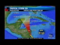
Ida made landfall as a Hurricane near Bluefields, Nicaragua this morning
– but tonight she has been downgraded to a Tropical Storm. Ida is expected
to continue to weaken and is currently moving very slowly over Nicaragua –
which means heavy rainfall for the mudslide prone areas of Nicaragua and Honduras.
And while those countries are sure to experience some kind of extreme weather
event, Belize has its own concerns: specifically will Ida make it out into the
Gulf of Honduras and when she does, will she pose a threat to Belize? And if
so, what do you need to be prepared for and when? Jacqueline Godwin went looking
for answers today.
Jacqueline Godwin Reporting
Hurricanes are sometimes very difficult to predict. In the case of Hurricane
Ida, this storm is expected to re-emerge in the north-western Caribbean. If
it does, it will be either be a depression or something weaker. Whatever the
case, rain is expected to affect the south and the coast of Belize. Because
Belize City is situated along the coastline, today the City Emergency Management
Organization met to prepare for whatever may blow our way.
And according to Meteorologist Derrick Rudon while it remains uncertain if
the system which was downgraded to Tropical Storm Ida earlier today will survive
her travel across north eastern Nicaragua and Honduras, if it does, it will
be a rainmaker.
Derrick Rudon, Meteorologist
“Here in Belize we can expect about 2 to 4 inches of rainfall per
day.”
And with that volume of rainfall in twenty four hours, flooding is expected 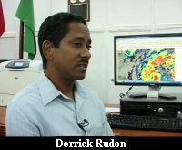 so families living in low lying areas in the south and along the coast especially
in vulnerable areas in Belize City are asked to monitor the system and remain
on the alert.
so families living in low lying areas in the south and along the coast especially
in vulnerable areas in Belize City are asked to monitor the system and remain
on the alert.
Jacqueline Godwin,
“Presently we notice that the system is over land. When do you expect
to re-emerge in the north western Caribbean?”
Derrick Rudon,
“The system will spend about 2 days or so over land and re-emerge
in the northwestern Caribbean around Saturday morning.”
Jacqueline Godwin,
“What does that mean for us?”
Derrick Rudon,
“That means that our weather will continue cloudy and showery over
the next couple days. Over the next two to three days we can expect cloudy and
showery weather. Especially, most of the rainfall will be over the sea, the
coast, and the south.”
Jacqueline Godwin,
“Well we know that the ground is already saturated because it has been
raining for the past few days. So when should we expect to see conditions worsen?”
Derrick Rudon,
“We can expect over the next 24 hours to see an increase in showers.”
And while upper level conditions are not favourable for the storm to intensify,
if it does enter the northwestern Caribbean Sea where the water temperature
is eighty five degrees there is that possibility Ida can strengthen. Its track
also remains uncertain and that is why the City Emergency Management Organization
has been making the necessary steps in the case of an event.
Philip Willoughby, CEMO Rep.
“All of our committees and agencies and support committees will be
in a state of alert going into the weekend. Everybody will be in a state of  alert and be ready to activate if needs be based on the information and the
guidance that would come from the Ministry.”
alert and be ready to activate if needs be based on the information and the
guidance that would come from the Ministry.”
If the storm does make it out into the north western Caribbean only one of
the modules predict a projected track over northern Belize. Most modules show
a north westerly track that will greatly minimize the effects of the storm on
the country. But because of its projected close proximity to the country the
National Meteorological Centre has been keeping a close watch on its progress.
Derrick Rudon,
“If the system re-emerges and is a fairly strong system then the steering
currents will continue the way it is shown there, it will continue to move it
to the north northwest. If it is a weaker system then the low level flow will
carry it more than the mid to upper level floor and as a weaker system then
it would move more to the west which isn’t good for us…more water
for us.”
Equally concerning is that for most of the day Tropical Storm Ida remained
stationary which makes it even more difficult to forecast.
Derrick Rudon,
“Yes there are concerns. It is close to us, it is in our warning area
but because of the motions there are no warnings at this time but if it re-emerges,
they might be warnings when it re-emerges. We might have to put up the flags
and so on. It depends on how strong it is and what direction it decides to go.
Stay in tune to the radio or the television and keep abreast as to what’s
happening, any developments with the storm. Keep up to date on the situation.”
Philip Willoughby,
“Anything can happen, any number can play but I want to assure the
residents of the city and the surrounding areas on behalf of us that we are
paying attention to the system, we are monitoring everything and we are listening
and will take guidance from the Ministry as with regards to how we proceed forward.”
And while tropical storm Ida formed in our area late in the hurricane season
it is not the first. On November twentieth, 1971 tropical storm Laura formed
and did affect the country. Reporting for 7News, Jacqueline Godwin.
According to the National Meteorological Service in our history of
hurricanes which dates back to 1889, there have only been three that have formed
in the month of November and affected the country. The first was an unnamed
tropical storm on November third, 1898, a category two hurricane on November
ninth, 1942 and on November twentieth, 1971, Tropical Storm Laura. Let’s
hope that Tropical Storm Ida does not become number four.
Channel 7


