General Situation:
Ambergris Caye: Conditions this morning by Elbert just before or after this post!
Belize NMS:
Present Condition: Mostly cloudy skies this morning, especially in the south. Mostly cloudy and windy in San Pedro. A relatively moist and unstable environment exists over the area.
Advisories: None.
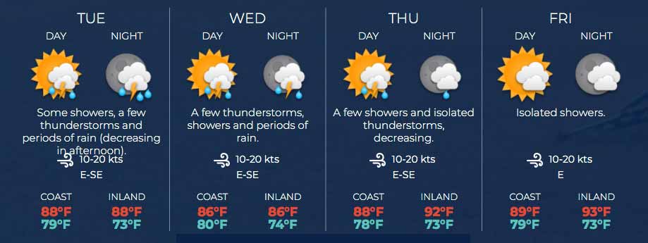
24-hour forecast:
Sunny with a few cloudy spells today and cloudy at times tonight. Showers or thunderstorms will be isolated, except for slightly more occurring over inland areas this afternoon. Then, some showers, a few thunderstorms and periods of rain will occur over the south at first tonight, and spreading to most areas.
Winds: E-SE, 10-20 kts Sea State:
Choppy
Waves: 3-5 ft.
Sea Surface Temperature (°f): 86
Outlook:
For Tuesday and Tuesday night is for some showers, a few thunderstorms and periods of rain occurring across the country, with a decrease in activity during the afternoon.
Sargassum Forecast from June 23 to June 30:
Satellite imagery continue to show high sargassum contents over our area and as a result the chances of sargassum landing on beaches across the country will remain high during the next few days. San Pedro has a high probability and a major impact.
Tropical Weather Outlook:
At 6:00 am, a well-defined low pressure system was located about 190 miles ESE of Hilton Head Island, South Carolina. The system is moving west-northwestward and has a high chance of further developing to a tropical cyclone.
Click for more...
Marine Conditions:
Live Beach Cam at Blue Water Grill
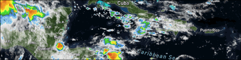
The Caribbean Sea
Aside from convection associated with the tropical waves in the Caribbean, no significant showers and thunderstorms are occurring.
Winds are mainly gentle to to moderate in the NW Caribbean,
moderate to fresh in the eastern Caribbean, and fresh in the
central Caribbean. Locally strong winds are occurring just off the
coasts of Colombia and Venezuela. Seas average 2 to 4 ft in the
western Caribbean, 4 to 6 ft in the eastern Caribbean, and 5 to 7
ft in the central Caribbean.
The monsoon trough is along 09N/10N between 75W in Colombia,
beyond Costa Rica, into the eastern Pacific Ocean. Convection
associated with this tough has diminished overnight.
The tropical wave currently approaching Jamaica will move west
across the basin into tonight. Winds and seas will increase as
high pressure builds over the basin following the tropical wave.
Another robust tropical wave will approach the Lesser Antilles Wed
or Thu, bringing gusty winds and showers and thunderstorms to
portions of the eastern Caribbean late in the week.
For the North Atlantic...Caribbean Sea and the Gulf of Mexico:
The Atlantic basin remains free of organized tropical systems, though there are a few features that bear watching into the coming week.
One concern is an area of low pressure that is tracking to the west across the southwestern Atlantic. This feature can potentially form into a tropical depression before moving into Georgia and South Carolina late Monday. This will bring an enhancement of showers and thunderstorms to Georgia and South Carolina through Tuesday.
There is also a robust tropical wave in the eastern Atlantic that is producing areas of rain and thunderstorms. This wave is moving westward rather quickly, at about 20 mph. At this pace, it can reach the Lesser Antilles around midweek. There can be some gradual development with this as it tracks across the Atlantic and it is possible that this can gain enough organization to become a tropical depression during the first half of the week, though there is not much support for significant strengthening. This can at least bring gusty showers and thunderstorms across the western Caribbean around the middle of the week.
For further information on tropical conditions, check the daily Tropical Weather Outlook, click here.
The opinions and views expressed on this board are the subjective opinions of Ambergris Caye Message Board members and not of the Ambergris Caye Message Board its affiliates, or its employees.


 General Situation: