Previous Thread
Next Thread
Print Thread
Page 2 of 16 1 2 3 4 15 16
Joined: Oct 1999
Posts: 84,398
Marty Offline OP
OP Offline
Navy, who historically has the best guesses on the storm tracks, now has a partial track...

[Linked Image]

Here's the USA Natl Weather Service track:

[Linked Image]

Here's the track forecasts from Wunderground

[Linked Image]

Joined: Oct 1999
Posts: 84,398
Marty Offline OP
OP Offline

Invest 97L Still Not Yet Officially A Tropical Storm, But Is Expected To Become One Sometime Today; Invest 97-L Will Continue To Impact Jamaica & The Cayman Islands Today Through Tonight & Then The Yucatan Peninsula & Belize From Wednesday Afternoon Through Thursday As A Tropical Storm & Possibly A Hurricane

For those of you in Belize & the southern Yucatan Peninsula & the north coast of Honduras - Tropical storm and possibly hurricane conditions could begin to impact you Wednesday afternoon and continue through all of Wednesday night and Thursday. Even though there are no watches or warnings in effect, you should prepare now for hurricane conditions, just in case this system strengthens considerably before making landfall on Wednesday night.

The latest track model guidance of Invest 97-L are all in good agreement on a landfall in Belize as at least a tropical storm on Wednesday night. From there, the track guidance spread out a bit with their forecast tracks of Invest 97-L. A majority of the guidance members forecast a straight west to west-northwest track into the Bay of Campeche and then southern Mexico, however, the GFDL model suite forecasts a turn to the northwest towards northeast Mexico and south Texas by Saturday morning. Given the strong ridge of high pressure over Texas and Louisiana, I am disregarding the GFDL model suite and think a straight west or west-northwest track into southern Mexico seems much more likely right now.

Here Are My Thoughts On Invest 97-L: Even though Invest 97-L is a little less organized than at this time yesterday due to some southwesterly wind shear impacting it, I still think that it is already a tropical storm. Reconnaissance aircraft are now investigating this system to confirm or deny whether we do have a tropical storm. It should be noted, however, that environmental conditions become quite favorable in the western Caribbean, especially around 85 West Longitude as this is when it is forecast to slow down in forward speed and be able to take advantage of the geography near the Gulf of Honduras. So, if Invest 97-L is not a tropical storm right now, it very likely will be once it nears the Yucatan Peninsula and Belize on Wednesday and Wednesday night.

We are also going to have to watch out for a rapid spin-up before it makes landfall in the southern Yucatan Peninsula and Belize on Wednesday night as environmental conditions are forecast to be quite favorable in the western Caribbean. This means that we need to strongly consider that Belize, parts of the Yucatan Peninsula and the north coast of Honduras may be impacted with hurricane conditions starting on Wednesday afternoon and continuing through Wednesday night and Thursday. All interests in Belize, the southern Yucatan Peninsula and the north coast of Honduras should be preparing now for at least tropical storm conditions and very possibly hurricane conditions.


Crown Weather

Click for the Daily Tropical Weather report


Joined: Oct 1999
Posts: 84,398
Marty Offline OP
OP Offline
Word from the National Hurricane Center is that reconnaissance aircraft have found that Invest 97-L is indeed a tropical storm. Based on this information, they will be initiating advisories on Tropical Storm Earl by 12 pm EDT/11 am CDT today.

Joined: Oct 1999
Posts: 84,398
Marty Offline OP
OP Offline

Second press release from the San Pedro NEMO - EOC

2st August 2016

The National Emergency Management Organization (NEMO) - Emergency Operations Committee (EOC) in San Pedro Town and Caye Caulker, have been meeting to discuss the plan of action of the fast approaching tropical wave.

Residents on Ambergris Caye and Caye Caulker are being advised to begin start making preparations to secure properties. NEMO reminds boat operators and owners to start taking necessary steps to secure their vessels and advise vessels to remain in safe harbour.

Contractors and hardware store owners are being asked to remove any and all items above their building that can be flying missiles during a storm. Hotel and resort owners are being asked to begin to put in place measures to secure their guests and employees.

San Pedro Belize Express and Belize Ocean Ferry remain on standby should evacuation is necessary. IF evacuation off the island is necessary, shelterees will be transported to the Belmopan UB gymnasium in Belmopan City.

Residents living on both islands are being advised to begin taking steps to secure their belonging and property. In addition, residents must continue to be keen and be prepared to relocate or evacuate if necessary. Residents living in flood prone areas are being advised to consider moving into higher and dry areas before the storm.

Shelters on Ambergris Caye are San Pedro High School in the Boca del Rio Area, the San Pedro Roman Catholic School in the downtown area and New Horrizon Seventh Day Adventist School in the DFC area. In Caye Caulker, the shelter is Caye Caulker RC School. Shelter will be open on the advised of NEMO.

Those people who will be moving from low-lying areas into the shelters are being advised to adhere to the shelters rules. Shelterees are asked to take along ample supply of water, food, basic first-aid kit, battery powered radio, flashlights and extra batteries, sanitary supplies, personal documents, blankets, extra change of clothes for a maximum of three days. Shelterees may be search by Police officers to ensure the shelterees' safety. Pet owners are responsible to make plans to secure pets since they are not allowed in hurricane shelters.

Expecting mothers and families with young children are hereby advised to consider evacuation before the storm. Residents with chronic illness are being advised to restock on their personal medical supplies.

All liquor establishments and shops that are the holders of a liquor license are being advised that the sale of liquor is being suspended as of 6PM on Wednesday August 3rd until the all-clear is declared by NEMO.

Members of the Belize National Coast Guard and the Belize Police Department remains on both islands to secure life and property.

NEMO in San Pedro and Caye Caulker continue to advise everyone to listen to their local radio and television for official NEMO advisory and to heed to all warnings when issued. The other meeting of the San Pedro EOC is scheduled for 1:00 PM. For any information or question, the San Pedro EOC can be contacted at (501) 226-4458, (501) 226-4358 and (501) 226-4824 and located at the San Pedro Town Council Conference Room. The Caye Caulker EOC is situated at the Seaside Villas Hotel.

San Pedro EOC - NEMO


Joined: Oct 1999
Posts: 84,398
Marty Offline OP
OP Offline

...AIR FORCE HURRICANE HUNTER PLANE FINDS TROPICAL STORM EARL IN THE NORTHWESTERN CARIBBEAN SEA... ...EARL IS THE FIFTH TROPICAL STORM OF THE 2016 HURRICANE SEASON...

Max winds predicted at 63phs (55 knots)

Data from an Air Force reconnaissance plane indicate that the strong wave we have been tracking for days has developed a closed circulation center with an estimated pressure of 1001 mb. On this basis, advisories on Tropical Storm Earl have been initiated. This is the fifth tropical storm of the 2016 hurricane season.

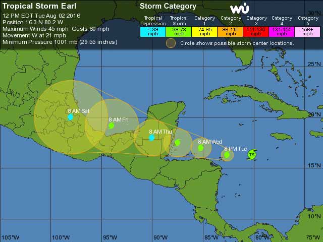
At 1200 PM EDT (1600 UTC), the center of Earl was located near latitude 16.3 North, longitude 80.2 West. Earl is moving toward the west near 22 mph (35 km/h), and this motion with a decrease in forward speed is expected during the next couple of days. On this track, the center of Earl will be moving very close to the north coast of Honduras late tonight and Wednesday and approach Belize and the Yucatan peninsula late Wednesday.

Maximum sustained winds are near 45 mph (75 km/h) with higher gusts. Some additional strengthening is forecast before Earl reaches the Yucatan peninsula.

Tropical-storm-force winds extend outward up to 80 miles (130 km) from the center.

The minimum central pressure estimated from an Air Force plane was 1001 mb (29.56 inches).

The overall convective pattern was a little less organized this morning, but recent images indicate that an area of deep convection is forming near or over the center. The upper-level outflow is not well established yet in all quadrants due to some shear. Most of the global models show that the upper-level environment should become more favorable with less shear. The NHC forecast calls for some intensification, and Earl is expected to be near hurricane strength by the time the center approaches the Yucatan peninsula.

Earl has been moving westward rapidly around 19 kt embedded within very strong easterly flow around the periphery of the Atlantic subtropical high. The ridge extends westward across the southern United States, and this pattern should maintain the cyclone on a general westward track across Belize and Yucatan during the next couple of days. After that time, a weakened Earl should move over the southern Bay of Campeche and southern Mexico. The cyclone should slow down during the next 12 to 24 hours since the steering currents are expected to be weaker. Most of the dynamical guidance agree on this scenario, and the NHC forecast very closely follows the multi-model consensus.

FORECAST POSITIONS AND MAX WINDS

INIT  02/1600Z 16.3N  80.2W   40 KT  45 MPH
12H 03/0000Z 16.3N 82.6W 45 KT 50 MPH 24H 03/1200Z 17.0N 85.2W 50 KT 60 MPH 36H 04/0000Z 17.5N 87.5W 55 KT 65 MPH 48H 04/1200Z 18.0N 90.0W 30 KT 35 MPH...INLAND 72H 05/1200Z 19.2N 94.0W 40 KT 45 MPH...OVER WATER 96H 06/1200Z 20.0N 98.0W 25 KT 30 MPH...INLAND 120H 07/1200Z...DISSIPATED

The Governments of Mexico and Belize have issued a Tropical Storm Warning and a Hurricane Watch for the east coast of the Yucatan peninsula from Punta Allen, Mexico, southward to the Belize/ Guatemala border.

The Government of Honduras has issued a Tropical Storm Warning for the entire north coast of Honduras from Cabo Gracias a Dios westward to the Honduras/Guatemala border including the Bay Islands.

SUMMARY OF WATCHES AND WARNINGS IN EFFECT:

A Tropical Storm Warning is in effect for... * Punta Allen, Mexico, southward to the Belize/Guatemala border.

A Tropical Storm Warning is in effect for... * Cabo Gracias a Dios westward to the Honduras/Guatemala border including the Bay Islands.

A Hurricane Watch is in effect for... * East coast of the Yucatan peninsula from Punta Allen, Mexico, southward to the Belize/Guatemala border.

A Tropical Storm Warning means that tropical storm conditions are expected somewhere within the warning area within 36 hours.

A Hurricane Watch means that hurricane conditions are possible within the watch area. A watch is typically issued 48 hours before the anticipated first occurrence of tropical-storm-force winds, conditions that make outside preparations difficult or dangerous.

WIND: Tropical storm conditions are expected to first reach the coast of Honduras by late tonight, making outside preparations difficult or dangerous, and will reach Mexico and Belize within the warning area by Wednesday night. Hurricane conditions could begin in Mexico and Belize within the hurricane watch area Wednesday night.

RAINFALL: Earl is expected to produce an additional 2 to 4 inches of rainfall over Jamaica. Total rain accumulations of 8 to 12 inches are expected over portions of Belize, Honduras, Guatemala, and the Yucatan peninsula of Mexico, with possible isolated maximum amounts of 16 inches in Mexico and Belize. These rains could result in life-threatening flash floods and mud slides.

STORM SURGE: A storm surge will raise water levels by as much as 2 to 4 feet above normal tide levels along the immediate coast of Belize and the eastern Yucatan peninsula to the north of where the center makes landfall. Near the coast, the surge will be accompanied by large and damaging waves.


For more information, click for our daily Tropical Weather Report


Joined: Oct 1999
Posts: 84,398
Marty Offline OP
OP Offline

"Earl will approach Belize and the southern part of the Yucatan Peninsula of Mexico with heavy rain and gusty winds later Wednesday or Wednesday night," Kottlowski said.

The northern coast of Belize, as well as low-lying areas in the Mexico state of Quintana Roo, could be subject to coastal flooding and beach erosion. In addition to the threat of flooding, trees can be knocked over and power outages are possible.

The very fast forward motion will limit strengthening so that Earl probably does not have enough time to become a hurricane.

The extent and severity of the rain and wind will depend on the strength of Earl at landfall. Flooding and sporadic power outages can occur even if a tropical storm or minimal hurricane moves ashore.

Accuweather


Joined: Aug 2016
Posts: 4
M
Offline
M
Marty,

Given the latest info, do you still think we should fly in today or not at all. I am concerned with the aftermath from the storm as well. We don't really want to spend a week on the island if we won't be able to enjoy it. Any thoughts are welcome

Thanks

Joined: Oct 1999
Posts: 84,398
Marty Offline OP
OP Offline
Hi Max, the latest information changes nothing, it confirms what I thought before... it doesn't look (right now) like it will be a bad storm.... some wind and rain for sure. and folks on the island HAVE to get ready just in case....

This still looks more like a Tropical Wave.
Its active ITCZ type swell-up areas keeps splitting during the day time.

The western caribbean is warm though, and it could approach hurricane force (75mph winds) as it nears the coast. on Wednesday night

Joined: Oct 1999
Posts: 84,398
Marty Offline OP
OP Offline
from Crown Weather just now... pretty much the same....

Even though Earl is a little less organized than at this time yesterday, an area of deep thunderstorm activity has develop near or right over the center of circulation. Environmental conditions are forecast to become increasingly more favorable for strengthening of the storm. This means that Earl could be near or at hurricane strength by the time it approaches Belize and the Yucatan Peninsula on Wednesday evening.

For those of you in Belize & the southern Yucatan Peninsula & the north coast of Honduras - Tropical storm and potentially hurricane conditions could begin to impact you during Wednesday afternoon and continue through all of Wednesday night and Thursday. So, prepare now for hurricane conditions, just in case this system strengthens considerably before making landfall on Wednesday night.

I am still concerned that we could see a fairly rapid spin-up before it makes landfall in the southern Yucatan Peninsula and Belize on Wednesday night as environmental conditions are forecast to be quite favorable in the western Caribbean. This means that Belize, parts of the Yucatan Peninsula and the north coast of Honduras may be impacted by hurricane conditions starting on Wednesday afternoon and continuing through Wednesday night and Thursday. So, to stress once again, all interests in Belize, the southern Yucatan Peninsula and the north coast of Honduras should be preparing now for hurricane conditions.

For more information, click for our daily Tropical Weather Report


Joined: Oct 1999
Posts: 84,398
Marty Offline OP
OP Offline

NEMO PUBLIC ADVISORY 5, Phase 2 in effect

TROPICAL STORM EARL FORMS EAST OF BELIZE

NEMO hereby informs that Tropical Storm Earl has formed in the Central Caribbean. TS Earl is moving due west at 22 mph with winds of 47 mph. Present location is 16.3 north latitude and 80.2 west longitude. The system is likely to make landfall on Wednesday night/ early Thursday morning. Tropical Storm have the potential for further development into a Category 1 Hurricane.

NEMO hereby declares Phase 2, one red flag with black centre is to be flown. A Tropical Storm Warning/ Hurricane watch is in effect for Belize. This means that within 24 hours' time we should experience rough seas, wind gusts in excess of 50 miles per hour and continuous rainfall along the coast drifting westward over Belize. We are anticipating storm surge of about 2-4 feet high and up to 16 inches of rainfall which can result in flood conditions.

Likely damages associated with these conditions are flooding of crops, uprooting of trees, destruction to poorly constructed and older timber buildings; loose items becoming projectiles damaging windows and doors. Broken glass, exposed nails, wood splinters and down power lines are dangerous; coastal roads will experience flooding and minor piers could suffer damage, boats can be washed away; damage to power lines and poles could result in power outages. Flooding pose a direct threat to life, contaminated water and sanitation systems poses serious health risks.

Actions being taken by NEMO.

  • All national and district committees have been activated and are conducting their implementation meeting.
  • Boats, buses and shelters being prepared to evacuate, transport people from the cayes and receive people in Belize City who need to shelter on the mainland.
  • San Pedro committee, CEMO and NEMO in Belmopan will be opening shelters in the morning for people to weather the storm. Public Officers assigned Shelter duties in these communities are to report to their Human Resource Coordinator.
  • All National Liaison Officers to report to the National Emergency Operations Centre, NEMO building for 1:00 p.m. today.
Actions to be carried out by the public.
  • Listen to the advisories. Stay alert.
  • Parents are hereby urged to check on their children and family members on vacation, make sure they are safe.
  • All who need to evacuate, put your evacuation plan into action. If it is not safe where you are be it the cayes or along the coast, move to the mainland. It is advisable if you will leave the cayes, do so starting today.
  • If you are going to shelter know which shelter you will go to and how you will get there. Take along your food, water, medications, and personal hygiene items so you can survive and weather the storm for a few days.
  • If you live in a flood prone area and along the coast and your home is not safe you are strongly advised to move early to a shelter in your area.
  • Residents and local authorities are encouraged to quickly organize and clear drains that can reduce flooding in their area. Start putting your emergency plan in place. Stock up on food, water, medication and shutter your home.
  • Mariners especially small craft must seek safe harbour /stay in port within 24 hours. Note. Cruise ships have already diverted from our area. Water Taxis are to monitor sea state conditions and be prepared to cease operations in accordance with seas state and safety of life at sea conditions.

NEMO urges all to remain alert but calm. Do not listen to rumours! Listen to your local radio and television for further advisories from NEMO and the National Met Service.


Page 2 of 16 1 2 3 4 15 16

Link Copied to Clipboard
April
S M T W T F S
1 2 3 4 5 6
7 8 9 10 11 12 13
14 15 16 17 18 19 20
21 22 23 24 25 26 27
28 29 30
Cayo Espanto
Click for Cayo Espanto, and have your own private island
More Links
Click for exciting and adventurous tours of Belize with Katie Valk!
Who's Online Now
0 members (), 135 guests, and 0 robots.
Key: Admin, Global Mod, Mod
Forum Statistics
Forums44
Topics79,204
Posts500,028
Members20,468
Most Online7,413
Nov 7th, 2021


AmbergrisCaye.com CayeCaulker.org HELP! Visitor Center Goods & Services San Pedro Town
BelizeSearch.com Message Board Lodging Diving Fishing Things to Do History
BelizeNews.com Maps Phonebook Belize Business Directory
BelizeCards.com Picture of the Day

The opinions and views expressed on this board are the subjective opinions of Ambergris Caye Message Board members
and not of the Ambergris Caye Message Board its affiliates, or its employees.

Powered by UBB.threads™ PHP Forum Software 7.7.5