|
|
Joined: Oct 1999
Posts: 84,398
|
OP

|
NEMO ADVISORY NO. 1: TROPICAL STORM HARVEY MOVING WESTWARD IN THE CARIBBEAN
The National Emergency Management Organization in collaboration with the National Meteorological Service hereby informs the public that Tropical Storm Harvey is located near latitude 13.4 North, and longitude 62.9 West or approximately 1,700 miles east of Belize. Harvey has sustained winds of 40 miles per hour (mph) and is moving to the West at 21 miles per hour. If it maintains its projected path over the next 3-4 days based on the forecast, the country could be affected by the tropical storm or higher conditions sometime between Tuesday and Wednesday or thereafter. Over the next 3-4 days, the only concern for Belize is Tropical Storm Harvey.
� The public is hereby advised to make some preparations to protect life and property. If you are at risk of bad weather and flooding make arrangements for the next week you will move away from the coast to higher grounds. If you have to seek shelter next week, know which shelter you will go to. Prepare how you will reach to your shelter. Check on family members and neighbors who may be in need of assistance. On the current projection for TS Harvey, the window of opportunity to relocate from coastal areas will be next Monday evening August 21st, 2017.
� During the weekend, if you don't have plans to go to sea, stay on the mainland. Start reviewing and implementing parts of your family, business emergency plan. Be prepared to put up shutters, fuel up your vehicle and generator. If you can, put together at least 3 days supply of water and non-perishable food. Ensure you purchase only approved medication. Essential services and Public Officers use the weekend to prepare your home and family in the event you are called out for emergency duties next week.
� Enjoy your weekend but take precaution and start your preparations. It is not expected that TS Harvey will affect the country over the weekend. Stay calm, this is just an alert.
� Drivers are always reminded to drive with extreme caution.
NEMO emergency coordinators can be reached as follows:
Corozal, Mr.Williard Levy at 623 0237;
Orange Walk, Ms. Suliema Celiz at 605 5046, or Mr. Aragon at 636 6094;
Belize District, Mr. Lionel Tillett at 6154834 and Mr. Kevin Pollard at 621 2275;
San Pedro, Ms. Vanessa Parham at 632 3698;
Belize City, Ms. Timrose Augustine at 600 8672 or Councillor Willoughby at 630 9793;
Belmopan, Ms. Clare Moody at 630 9791;
Cayo, Mr. Al Westby at 630 3224 or Mr. Johnny Ramclam at 625 2526;
Stann Creek, Mr. Keith Emmanuel at 615 9711; and
Toledo, Mr. Kenton Parham at 630 9787.
The NEMO Emergency Hotline is 936. NEMO IS ON ALERT BUT NOT ACTIVATED.
The public is asked to pay attention to the official reports and advisories from the National Meteorological Service and NEMO. Advisories will be sent out as the need arises. All are encouraged to monitor TS Harvey.
|
|
|
|
|
Joined: Oct 1999
Posts: 84,398
|
|
OP
|
Navy track this morning, not much change.... ![[Linked Image]](//Ambergriscaye.com/art6/al092017dsdsdss.jpg) Wind shear continues to keep the system from intensifying significantly, but this will likely change some over the next day or two. Tropical Storm Harvey is located near 13.8N 65.9W at 19/0900 UTC, or about 243 nm south of St. Croix, moving west at 18 kt. Estimated minimum central pressure is 1005 mb. Maximum sustained wind speed is 35 kt with gusts to 45 kt. Harvey will continue to move westward at a quick pace over the next 12-24 hours, moving into a less hostile environment this weekend. Low wind shear and very warm water will likely aid in development. Additionally, Harvey should slow down in forward speed later today or Sunday, which will also contribute to further development. There are still many discrepancies with regard to the precise track early next week, and this will also play a role in the intensity forecast. A farther north track (north of Honduras) would favor a stronger system, while a southern track will lead to more land interaction and reduce the window for intensification. Right now, Harvey will most likely affect far northern Honduras and the Yucatan Peninsula by Monday or Tuesday.
|
|
|
|
|
Joined: Oct 1999
Posts: 84,398
|
|
OP
|
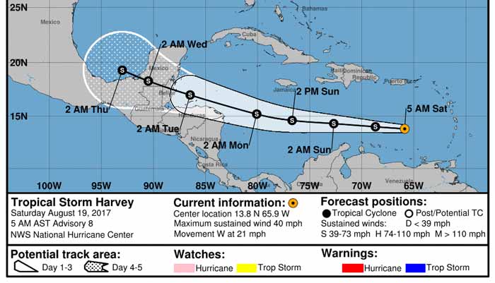
Harvey Will Move Across The Caribbean This Weekend With Tropical Storm Conditions Expected Across Honduras, Belize & The Yucatan Peninsula From Monday Through Tuesday
Tropical Storm Harvey:
5 am EDT/4 am CDT Statistics:
Location: 13.8 North Latitude, 65.9 West Longitude or about 235 miles to the east-northeast of Curacao.
Maximum Winds: 40 mph.
Minimum Central Pressure: 1005 Millibars or 29.68 Inches.
Forward Movement: West at a forward speed of 21 mph.
Satellite imagery and analysis of environmental conditions indicates that the center of Harvey is being exposed by northerly wind shear of 10 to 15 knots. Most of the thunderstorm activity is being pushed to the east of the center. It appears that the storm is relatively weak in strength and will probably remain weak until it reaches the western Caribbean on Monday. Once it reaches the western Caribbean, it is expected to find itself in a more favorable environment for intensification before it moves inland into Belize and the Yucatan Peninsula on Tuesday as a 50-70 mph tropical storm.
By about Thursday, Harvey is expected to move into the Bay of Campeche and its track beyond this is somewhat in question.
Everyone Across The Yucatan Peninsula, Belize & Northern Honduras: Tropical storm conditions, including up to 50 mph winds and heavy rainfall, are expected across northern Honduras on Monday and Monday night. For Belize and the Yucatan Peninsula, tropical storm conditions, including up to 60-70 mph winds, heavy rainfall and high surf, are expected to start after midnight Monday night and continue through Tuesday and Tuesday evening.
Model Track Forecast For Harvey:

Model Intensity Forecast For Harvey:

Satellite Imagery Of Harvey:

Crown Weather
For more information, check the daily Tropical Weather Outlook CLICK HERE.
|
|
|
|
|
Joined: Oct 1999
Posts: 84,398
|
|
OP
|
From Belmopan...
What does this look like to you. ?
A broken line of swell-ups or a Tropical Storm. ?
OK, it has time to reform before it gets to Belize, so keep watching.
1013 mb is normal pressure. 40 mph is hardly a storm, perhaps they keep quoting that figure, because 39mph or less is not even a Storm catagory.

|
|
|
|
|
Joined: Oct 1999
Posts: 84,398
|
|
OP
|
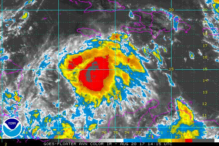
Wind Shear Rips into Tropical Storm Harvey
Tropical Storm Harvey, 92L Struggling, track remains steady: Time has not been kind to Tropical Storm Harvey, which entered the Caribbean as a minimal tropical storm on Friday. Hurricane Hunters were unable to find a closed circulation within Harvey at the 850 mb level (about a mile high) on Saturday morning. Because a closed circulation was found near the surface, the National Hurricane Center kept Harvey classified as a tropical storm at 11 am EDT Saturday. That may be generous, as no winds above tropical-storm strength (35 knots) were found at flight level by the Hurricane Hunters. Continuity may be a factor in keeping Harvey a tropical storm, since it is likely to move into a more nurturing environment later this weekend.
Located about 125 miles north-northeast of Curacao at 11 am EDT Saturday, Harvey was racing westward at 22 mph. Harvey's envelope of convection (showers and thunderstorms) had become much more fragmented and elongated, a byproduct of the storm's rapid motion coupled with persistently strong wind shear of 20-25 knots. It is possible Harvey will be stretched to the point where it loses its closed surface circulation and becomes an open wave by late Saturday. Assuming Harvey survives till Sunday, it will be moving into the western Caribbean, where wind shear is predicted by the 12Z Saturday SHIPS model to drop to the 5-10 knot range. Mid-level relative humidity should increase from around 50% to greater than 70%. This will give Harvey a much more supportive environment for strengthening. Sea-surface temperatures will remain quite warm along Harvey's path, around 29°C (84°F)-roughly 0.5°C above average. These warm waters are quite deep, providing ample oceanic heat content to enhance strengthening if Harvey does remain a tropical cyclone. The leading global models are in fairly good agreement on Harvey's general track over the next 3-5 days, but subtle shifts could make a big difference in Harvey's strength and long-term future. Most of the ensemble members from the 0Z Saturday runs of the GFS and European models take Harvey near or just north of the Honduras coast on Monday, with a landfall late Monday or Tuesday in Belize or Mexico along the east coast of the Yucatan Peninsula. A few ensemble members bring Harvey into far northern Nicaragua or eastern Honduras, in which case Harvey would likely weaken and might never reach the Yucatan. The official NHC forecast from 11 am EDT Saturday tracks Harvey into Belize as a strong tropical storm on Tuesday morning.
Jeff Masters / Category 6
For more information, check the daily Tropical Weather Outlook CLICK HERE.
|
|
|
|
|
Joined: Oct 1999
Posts: 84,398
|
|
OP
|
Harvey weakens to a tropical depression
The National Hurricane Center (NHC) is reporting that Harvey has weakened to a Tropical Depression. The center of Harvey is located near latitude 14.1 North, longitude 70.0 West, moving toward the west near 22 mph (35 km/h) and this general motion is expected to continue through Sunday. A turn toward the west-northwest is expected Sunday night or Monday.
On the forecast track, the center of Harvey will move across the central and western Caribbean Sea through Monday. Maximum sustained winds are near 35 mph (55 km/h) with higher gusts. Some slow strengthening is possible during the next couple of days, and Harvey could regain tropical storm status Sunday or Sunday night.
There are no coastal watches or warnings in effect.
|
|
|
|
|
Joined: Oct 1999
Posts: 84,398
|
|
OP
|
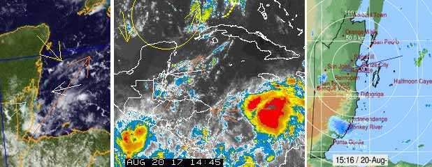
Tropical wave that was Harvey looking better organized
Showers and thunderstorms have increased this morning in
association with the remnants of Harvey. Gradual development of
this system is possible, and it could become a tropical cyclone
once again as it moves west-northwestward across the central and
northwestern Caribbean Sea during the next couple of days.
Interests in northern Nicaragua, Honduras, Belize, and the Yucatan
peninsula should monitor the progress of this system. An Air Force
Reserve reconnaissance aircraft is scheduled to investigate this
disturbance later today.
* Formation chance through 48 hours...medium...50 percent
* Formation chance through 5 days...medium...60 percent
A good deal of convection has developed around Harvey this morning, indicating that it might be regaining organized tropical characteristics. Tropical Rainstorm Harvey is approximately 250 miles south-southwest of Port-au-Prince Haiti and continuing west at about 16 mph. Harvey may become a tropical depression or tropical storm before it makes landfall by Tuesday morning in the Yucatan Peninsula.
Heavy rainfall with flooding and mudslides can be expected across northern portions of Honduras by Monday, as well as the Yucatan Peninsula on Tuesday. Depending on the degree of strength, there can also be damaging winds as Harvey approaches. This can lead to power outages and damage to weak structures.
|
|
|
|
|
Joined: Oct 1999
Posts: 84,398
|
|
OP
|
Harvey Will Move Into The Western Caribbean On Monday & Will Impact Honduras, Belize & The Yucatan Peninsula From Monday Night Through Tuesday
Remnants Of Harvey: After completely falling apart yesterday and being downgraded to a remnant storm, satellite imagery indicates that the shower and thunderstorm activity associated with Harvey is increasing this morning. This is likely because Harvey has moved from an area of stronger wind shear that plagued it yesterday into an area of lower shear this morning. In addition, analysis of environmental conditions across the western Caribbean indicates that the shear levels remain at least marginally favorable for the next couple of days. Given the increase in thunderstorm activity and the fact that the environment should be favorable enough for development, I think that we will see Harvey spin up again into a tropical storm between now and Monday evening. This means that tropical storm conditions can be expected across the southern Yucatan Peninsula, Belize and northern Honduras on Monday night into Tuesday.
Harvey is then forecast to cross the Yucatan Peninsula during the day on Tuesday and emerge in the Bay of Campeche on Wednesday and this is when its future track becomes questionable. At this point, I still think we are looking at a final landfall somewhere between Tampico, Mexico and Brownsville, Texas on Friday as probably a tropical storm or very possibly a hurricane. With that said, I still urge everyone along the coast of eastern Mexico and along the lower and middle Texas coast from Veracruz, Mexico to Matagorda Bay, Texas to keep a close eye on the progress and track of Harvey.
Everyone Across The Yucatan Peninsula, Belize & Northern Honduras: Tropical storm conditions, including up to 50 mph winds and heavy rainfall, are expected across northern Honduras on Monday and Monday night. For Belize and the southern Yucatan Peninsula, tropical storm conditions, including up to 60 mph winds, heavy rainfall and high surf, are expected to start after midnight Monday night and continue through Tuesday and Tuesday evening.


Crown Weather
For more information, check the daily Tropical Weather Outlook click here.
|
|
|
|
|
Joined: Feb 2004
Posts: 2,208
|
|
|
Harvey knew those bears were watching.
|
|
|
|
|
Joined: Oct 1999
Posts: 84,398
|
|
OP
|
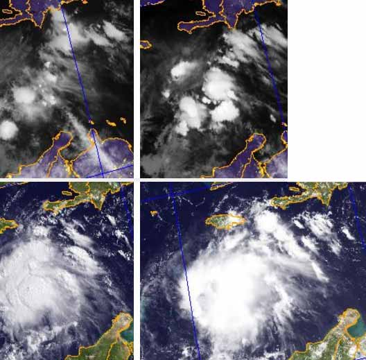
From Belmopan...
As expected, TS HARVEY has overnight, intensified. I still do not see any rotation, but certainly a lot of ITCZ type swell-up intensification. It also appears to be pushing that high level cloud that was going up over Cuba, more our way, causing some rain out at sea and isolated areas of rain on land. Harvey is acting rather like an intense Tropical Wave, not a tropical storm. The rotating air has moved more west and now over the gulf, some of its NW wind is clashing with the high level from the SSW and is causing rain over and near Belize.
This storm has not been so much about sea temperatures, but more about will it rotate or not.
I have not been seeing any significant rotation, but a bunch of intense ITCZ type swell-ups.
I try to say it as I see it, but at the same time, we have to be prepared and ready, in case it does things I have not seen and intensify into some form of damaging storm.
The present indication is little or no wind, but could be dangerous flooding rains.
What I have been noticing with Weather reporting over this Storm and the previous one, is that many weather sites and individuals keep saying or quoting the normal expected things and actions and developments.
My neighbour has boarded up his windows, because of the warnings. The previous storm had all sorts of strong warnings, despite what I was seeing and saying. This storm, I have not seen much typical Tropical Storm with it, which I have been saying all along. The trouble with weather people saying terrible warnings is people do the wrong preparation, and after two storms in a row with no wind, then tend to not be prepared to handle a real dangerous storm. Each Storm is different, with different actions, risks and dangers. We need to be told what each different storm might do and what their different dangers might be, even whilst hoping for the best, but be prepared for the worst. This is what I have been trying to do.
This Harvey may well bring a lot of rain to parts of Belize, or even most of Belize, there could be serious flooding, but I am not expecting strong winds, except ITCZ heavy rains can often cause their own local very strong wind or micro-bursts.
This is how Harvey developed over night and into this morning
|
|
|
|
S |
M |
T |
W |
T |
F |
S |
|
|
1
|
2
|
3
|
4
|
5
|
6
|
|
7
|
8
|
9
|
10
|
11
|
12
|
13
|
|
14
|
15
|
16
|
17
|
18
|
19
|
20
|
|
21
|
22
|
23
|
24
|
25
|
26
|
27
|
|
28
|
29
|
30
|
|
|
|
|
|
|
0 members (),
199
guests, and
0
robots. |
|
Key:
Admin,
Global Mod,
Mod
|
|
|
Forums44
Topics79,204
Posts500,028
Members20,468
| |
Most Online7,413
Nov 7th, 2021
|
|
|
|

![[Linked Image]](http://Ambergriscaye.com/art6/al092017dsdsdss.jpg)


