From Belmopan...
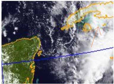
The collection of ITCZ activity that has been generally active in much of the western Caribbean from Panama to Yucatan, with its low pressure centre on or near Belize for much of the early part of this week, causing all that rain we had, was pushed away from Belize by the two cold fronts, but by yesterday, the easterly Caribbean winds were pushing those cold fronts away. But now there is a third cold front, not only approaching across the gulf towards us, but its front effects are already over and beyond Belize, pushing the Caribbean winds away and causing, or allowing the low pressure centre to now drift northwards, towards Cuba, taking the loose collection of ITCZ swell-ups with it, over Cuba and towards Florida. This has enabled the tropical storm people to flag it as a >60% potential tropical storm. But again, like Harvey, they are looking at ITCZ rain downdraughts for their wind speeds, trying to pin a TS name to nothing but normal ITCZ activity. Naughty.
But this general movement northwards, is now enabling some of the normal Pacific ITCZ activity to also move northwards, on to land, a bit nearer to Belize.
The cold air pushing in over Belize, with cloud over most of the country, with the north becoming clear. High level cloud pushing up from the SSW, which will slow the thinning of the low cloud.
Looks like today will start off cloudy, with sunshine spreading downwards from north Belize, no rain expected on land.


Temperatures in Belmopan :
( Coast usually cooler, hills even cooler )
Fri max. 27°C 80°F Last night min. 23°C 72°F
Ambergris Caye:
https://www.wunderground.com/q/locid:BHXX0104;loctype:1
Belmopan:
https://www.wunderground.com/personal-weather-station/dashboard?ID=MD1029#history
Caye Caulker:
https://www.wunderground.com/personal-weather-station/dashboard?ID=IBELIZED2#history


![[Linked Image]](http://Ambergriscaye.com/art6/oct-28th.jpg)