General Situation:
Ambergris Caye: Conditions this morning by Elbert just before or after this post!
Belize NMS:
Present Condition: Very cloudy this morning. Relatively moist and unstable conditions prevail over the area.
Advisories: None.
24-hour forecast:
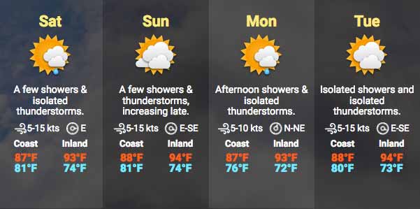
Cloudy this morning with sunny breaks this afternoon. A few showers and isolated thunderstorms will affect mainly coastal areas this morning and then inland areas this afternoon. Tonight will be partly cloudy with showers and thunderstorms becoming isolated.
Winds: East | 5-15 kts Sea State: Light Chop-Choppy
Sea Surface Temperature (°f): 86
Outlook:
A few showers and isolated thunderstorms will continue across the country on Saturday increasing further on Saturday night.
Tropical Weather Outlook:
Tropical cyclone formation is not expected in the North Atlantic, the Caribbean Sea or the Gulf of Mexico within the next 48 hours.
Click for more...
Marine Conditions:
Winds
Seas
Waves
Details
Today
E 5-15 kts
Light Chop-Choppy
2-4 ft
A FEW SHOWERS AND ISOLATED THUNDERSTORMS, DECREASING.
Tonight
E 5-15 kts
Light Chop-Choppy
2-4 ft
ISOLATED SHOWERS AND ISOLATED THUNDERSTORMS.
Tomorrow
E 5-15 kts
Light Chop-Choppy
2-4 ft
A FEW SHOWERS AND ISOLATED THUNDERSTORMS, DECREASING.
Outlook
E 5-15 kts
Choppy-Moderate
3-5 ft
A FEW SHOWERS AND THUNDERSTORMS.
The Caribbean Sea
The pressure gradient between high pressure over the central
Atlantic and surface troughing over the SW Caribbean is supportinf
fresh to strong winds over the south central Caribbean. Moderate
to fresh winds prevail over the remainder of the central Caribbean
as well as the eastern Caribbean. Gentle to moderate winds prevail
over the western Caribbean. Seas are in the 8-10 ft range over the
south central Caribbean, 3-5 ft over the NW Caribbean, and 5-7 ft
elsewhere. Isolated showers are embedded within the tradewind
flow.
High pressure N of the area will maintain fresh to strong trade
winds in the south-central Caribbean, and moderate to fresh winds
over most of the remainder of the basin through Sat. The aerial
extent of the trades will increase slightly Sat into Sun.
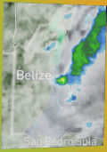
On Ambergris Caye this morning we have more rain and a cloudy sky. The sea is calm, wind is from the East at 10 mph. and the expected high temperature for the day is 86 f.
This heavy cloud and swellups have again been caused by a large rotation weather system that moved over the US with its swinging arm tht came down over Mexico first, then over the Yucatan and Belize. It made the high level more active and put something in between the high level and the easterly Caribbean winds to cause all the swellups. Swellups are still all up the Belize coast line and on land over the Belize District
Looks like a cloudy day for most, perhaps a little sun sometimes, but still rain along coastal areas.
Temperatures in Belmopan : ( Coast usually cooler, hills even cooler ) Last night min. 23°C 74°F Yesterday max. 34°C 93°F Yesterday Rain 28 mm ( 1.1" ) Over night Rain 3.2 mm ( 0.1" )
There is still a lot of activity over coastal areas. But, like yesterday, some of the action is moving backwards into central areas, presently Orange Walk district and Toledo.
Quarantine Line In Corozal
On May 8TH, 2020 various businesses had people waiting on line to get their necessities, their food items, Banks line and more. Since, the New Normal in Corozal, this what Quarantine in Corozal looks.
Present Condition: Quite cloudy with rain in some areas. 24hr Forecast: Cloudy with a few showers and isolated thunderstorms this afternoon, especially over inland areas. These will decrease over most areas tonight and then increase again on sat morning.
You can see the northern swing of weather, now centred on the north Atlantic, with its cloud arm extending across the North Caribbean and over Belize. There now appears to be another one, centred over the north east US, with its arm over Georgia and the top of the Gulf, which again, may have some effect on us in a few days time. Notice the high level cloud that develops in the Pacific, bottom left corner, which is coming over Belize from the SW Most ITCZ activity is over Panama and the north of South America.
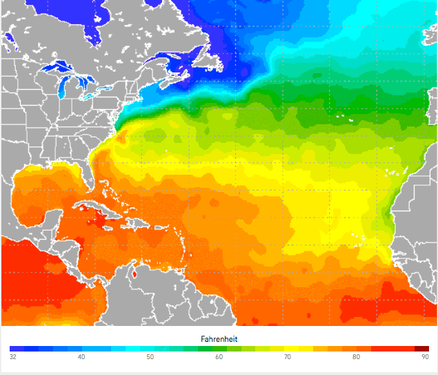
The Atlantic seas surface temperature is probably too cold to support hurricane activity as yet, but we need to watch, because ITCZ swellup activity can trigger a tropical storm.
The opinions and views expressed on this board are the subjective opinions of Ambergris Caye Message Board members and not of the Ambergris Caye Message Board its affiliates, or its employees.


 General Situation:


![[Linked Image]](http://Ambergriscaye.com/art8/belmopanwx200508.jpg)
![[Linked Image]](http://Ambergriscaye.com/art8/belmopanwx200508b.jpg)
![[Linked Image]](http://Ambergriscaye.com/art8/dailywx200508b.jpg)

![[Linked Image]](http://Ambergriscaye.com/art8/gfgffgifabpbpfho.jpg)


