General Situation:
Ambergris Caye: Conditions this morning by Elbert just before or after this post!
Belize NMS:
Present Condition: Quite cloudy this morning. Moist and unstable conditions continue to dominate our weather.
Advisories: *Flood Watch: A Tropical Disturbance over Central America this weekend into next week will support heavy rains and possible flooding over some areas of the country.*
24-hour forecast:
Mostly cloudy skies with a few showers, isolated thunderstorms and periods of rain over most areas, especially the south and inland.
Winds: East | 10-20 kts Sea State: Choppy
Sea Surface Temperature (°f): 86
Outlook:
For Sunday and Sunday night is for cloudy to overcast skies wit some showers, isolated thunderstorms and periods of rain over most areas.
Tropical Weather Outlook:
Tropical cyclone formation is not expected in the North Atlantic, the Caribbean Sea or the Gulf of Mexico within the next 48 hours.
Click for more...
Marine Conditions:
Winds
Seas
Waves
Details
Today
E 10-20 kts
Choppy
3-5 ft
A FEW SHOWERS, ISOLATED THUNDERSTORMS OR PERIODS OF RAIN.
Tonight
E 10-20 kts
Choppy
3-5 ft
A FEW SHOWERS, ISOLATED THUNDERSTORMS AND PERIODS OF RAIN.
Tomorrow
E-SE 10-20 kts
Choppy
3-5 ft
SOME SHOWERS, ISOLATED THUNDERSTORMS AND PERIODS OF RAIN.
Outlook
E-SE 10-20 kts
Choppy
3-5 ft
SOME SHOWERS, PERIODS OF RAIN AND ISOLATED THUNDERSTORMS.
The Caribbean Sea
...Heavy rainfall in Central America...
A Central American Gyre has developed in the eastern North
Pacific Ocean. The gyre will move northward, gradually, toward
Central America and southern Mexico, during the upcoming weekend.
The gyre will continue to push abundant moisture into parts of
Central America through the weekend, and into the next week.
Heavy rainfall is likely in Central America, especially from
northern Costa Rica northward into southern Mexico. Heavy
rainfall will bring the potential for life-threatening flash
floods and mudslides for the locations that receive the greatest
amounts of rainfall, especially in the areas of mountainous
terrain. Please read the bulletins and forecasts from your local
weather service for more information.
Broken to overcast multi-layered clouds and remnant showers, are
in the NW Caribbean Sea, related to what has been moving from
the Yucatan Peninsula, into the NW corner of the Caribbean Sea,
from the SW Gulf of Mexico upper level trough and clouds and
precipitation.
Broad upper level anticyclonic wind flow covers the Caribbean
Sea from 70W westward. Upper level cyclonic wind flow covers the
rest of the Caribbean Sea. The upper level wind flow is at the
southern end of the upper level trough that extends from the
central Atlantic Ocean, southwestward. This is the same upper
level trough that is near the 1015 mb Atlantic Ocean low
pressure centered near 28N56W.
The tropical wave that is south of central Cuba will move across
the western Caribbean Sea through Sunday. The wind speeds and
the sea heights will increase in the Gulf of Honduras, early
next week, as broad low pressure forms in the northern sections
of Central America and southern Mexico.
A tropical disturbance will support heavy rains over Central America this weekend, into next week, with the possibility of flooding over some parts of the country, especially low-lying and southern areas.
For more information, check the daily Tropical Weather Outlook, click here
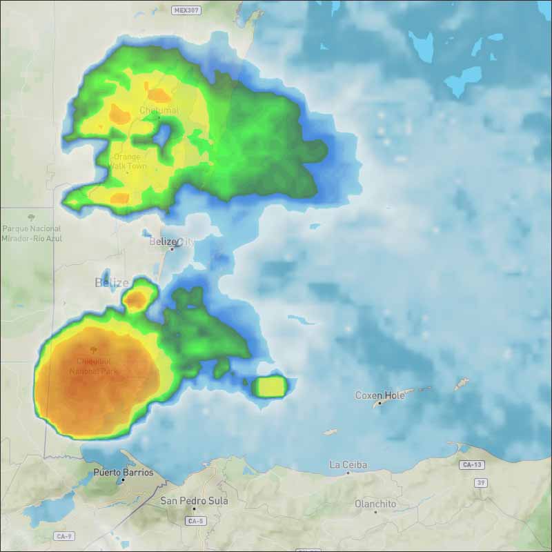
We have had, and still having a Large ITCZ type swellup, centred on central Belize, covering most of the country but not the extreme south or north. This has, and is still bringing a lot of rain 145mm 6" so far this morning in Belmopan, and a bit more to come. We have finally been caught by one of those proper ITCZ swellups, but still small compared to some that have been around Central America. I think this confirms my saying as of Wednesday 27th May, we are in the Rainy season.
There are a few patches of sun way down south, but mainly, the whole country under heavy cloud, which will probably not thin much or clear until late this morning, lighter rain continuing, with heavy rain in central north areas, and probably Belize City.
Temperatures in Belmopan : ( Coast usually cooler, hills even cooler ) Last night min. 24°C 73°F Yesterday max. 32°C 91°F Yesterday Rain 0 mm ( 0") This Morning Rain 145 mm ( 6" )
The ITCZ activity is swelling and now covering the whole of the north and new activity down south and up north. Still lots of rain for many in most parts of Belize right now. Rains just subsided in Benque 10 minutes ago.
Present Condition: 24hr Forecast: Skies will be mostly cloudy. Some showers, isolated thunderstorms and periods of rain, which may become heavy at times, will affect most places this afternoon through tomorrow morning.
Overnights rains have left the Mahogany Heights community inundated. Surrounding communities are advised that more rain is expected in the coming days.
Flooding along the Coastal Road.
Belmopan flooding - courtesy videographer at Plus TV, Cirilo Choco
There is a potential tropical storm developing on our door step, TROPICAL DEPRESSION TWO-E
It is unlikely to be anything more than a Tropical depression, so no hurricane winds, but there could be a lot of rain from it. It is probably responsible for getting the new swellup over southern Belize, to be moving northwards.
More rain coming up from the south
National Meteorological Service of Belize: � (11 pm update) Latest Infrared (IR) Satellite Imagery and our lightning detection system show severe thunderstorm activity once again occurring over central and southern Belize. Our automatic weather station in Belmopan has recorded almost 2 inches of rainfall over the last two hours.
Residents in these and other already flooded areas are asked to REMAIN ON ALERT and move to higher ground immediately as these rains are expected to continue.
The opinions and views expressed on this board are the subjective opinions of Ambergris Caye Message Board members and not of the Ambergris Caye Message Board its affiliates, or its employees.


 General Situation:


![[Linked Image]](http://Ambergriscaye.com/art8/101179511_1019427835126071_2645897302572531712_o.jpg)
![[Linked Image]](http://Ambergriscaye.com/art8/CAG_WU_setup-930px.jpg)


![[Linked Image]](http://Ambergriscaye.com/art8/calpkhgdccdagepb.jpg)
![[Linked Image]](http://Ambergriscaye.com/art8/dailywx200530b.jpg)
![[Linked Image]](http://Ambergriscaye.com/art8/belmopanwx200530g.jpg)
![[Linked Image]](http://Ambergriscaye.com/art8/belmopanwx200530u.jpg)
![[Linked Image]](http://Ambergriscaye.com/art8/101511171_945605279232526_7662268015940993024_n.jpg)
![[Linked Image]](http://Ambergriscaye.com/art8/101376845_945605299232524_3488257229608452096_n.jpg)


