General Situation:
Ambergris Caye: Conditions this morning by Elbert just before or after this post!
Belize NMS:
Present Condition: Cloudy this morning, especially in the north. The remnants of Eastern Pacific Tropical Storm Amanda will continue to support very moist and unstable conditions over the area.
Advisories: *Small craft caution in effect for occasionally gusty winds and locally rough seas, especially near heavy showers and thunderstorms. Remnants of Eastern Pacific Tropical Storm Amanda contiues to affect the region and redevelopment is possible if it emerges over the southern Bay of Campeche and has a medium chance of development during the next 48 hrs.Flood warning: Flooding due to heavy and persistent rainfall mainly over central and northern areas, is expected to continue near rivers and streams, and in low-lying and flood prone areas. There is a high possibility for flash-flooding, near communities along on the eastern slopes of the Maya Mountains.*
24-hour forecast:
Cloudy to overcast conditions, with some showers, thunderstorms and periods of rain continuing mainly over northern and northern offshore areas this morning, inland this afternoon and northern and central areas tonight.
Winds: E-SE, 10-20 kts , Gusty Sea State: Moderate-Rough Waves: 5-8 ft
Sea Surface Temperature (°f): 86
Sargassum Forecast:
Latest observations show that a few sargassum mats continue to drift into the area. This is expected to continue during the next few days with moderate impacts on local beaches.
Outlook:
Is for continuing cloudy skies with some showers, periods of rain and thunderstorms mostly central and north Tuesday morning, decreasing and becoming a few Tuesday afternoon and night.
Tropical Weather Outlook:
Tropical cyclone formation is not expected in the North Atlantic, the Caribbean Sea or the Gulf of Mexico within the next 48 hours.
Click for more...
Marine Conditions:
The Caribbean Sea
...Heavy rainfall in Central America and Southern Mexico...
A Central American Gyre is centered over northern Central America
and southern Mexico, with the broad cyclonic circulation around
the gyre encompassing southern Mexico and much of Central
America. Areas of thunderstorms continue to impact portions of
Central America from Nicaragua northwestward to Southern Mexico.
The remnant low of Amanda is now centered over N Guatemala, but
the focused area of circulation within the larger Central
American Gyre has led to torrential rainfall over portions of
Guatemala and El Salvador over the past 12 to 24 hours.
The Central American Gyre is producing showers and thunderstorms
across much of Central America and waters offshore central
America. Fresh to locally strong winds prevail over the Gulf of
Honduras. Gentle to moderate prevail elsewhere across the
Caribbean waters. Seas are in the 5-7 ft range over the Gulf of
Honduras, and 3-5 ft elsewhere.
A broad area of low pressure, known as the Central American
Gyre will persist over northern Central America and southern
Mexico during the entire week supporting heavy showers and
scattered thunderstorms over the NW Caribbean. Winds and seas
will also increase in the Gulf of Honduras and off Yucatan
through Fri as a result. The Bermuda High will rebuild to north
of the basin on Tue, which will lead to the development of fresh
winds in the south-central Caribbean Tue through Fri.
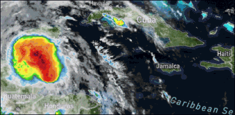
The Hurricane centre, in my opinion, have had this storm very wrong.. It was never a Tropical storm, and now they say REMNANTS OF AMANDA which is wrong, in that over the last two days, it was developing and never a Tropical storm, just a lot of rain from a moving Depression. Their track was also wrong. But now, I think it might be developing into a storm, as you can see at the 5am rain picture, when it gets into the sea. As far as we are concerned, it still has some high activity out at sea and on San Pedro and still rain up in the Corozal district, but that is moving northwards and away.
Looks as if today will be mainly cloudy, still rain in the north, some rain possible elsewhere and some sun later.
Temperatures in Belmopan : ( Coast usually cooler, hills even cooler ) Last night min. 24°C 75°F Yesterday max. 29°C 83°F Yesterday Rain 101 mm ( 4")
HEAVY RAINS CAUSE FLOODING IN CHETUMAL AND RURAL AREAS
Reports coming from neighbouring Chetumal, today is that the heavy rainfall from early this morning has caused flooding in the following areas and municipalities:
Centro, Barrio Bravo, Primera Legislatura, Nueva Reforma, 5 de Abril, Del Bosque, Adolfo L�pez Mateos, Comit� Proterritorio, Solidaridad, L�zaro C�rdenas, Venustiano Carranza, David Gustavo Guti�rrez, Leona Vicario, Nueva Italia y Benito Ju�rez, Arboledas, Municipalities of Oth�n P. Blanco/Chetumal, Bacalar, Jos� Mar�a Morelos, Felipe Carrillo Puerto, Tulum y Solidaridad.
Flooding has also been reported on farms and property, especially along the Rio Hondo in the communities like Revoluci�n y Cacao. Source Capital News Click photos for more pictures!
Present Condition: Clearer skies to the south, some easterly Caribbean wind. The storm moving north, away from Belize. Perhaps still some rain near San Pedro. 24hr Forecast: Cloudy to overcast conditions, with some showers, thunderstorms and periods of rain continuing mainly over northern and northern offshore areas this morning, inland this afternoon and northern and central areas tonight.
A flood alert is currently in effect and will continue for the remainder of the week, due to the remnants of Pacific Tropical Storm, Amanda, which crossed over the Central American isthmus over the weekend and dumped heavy rains over the area.
Rainfall over central and northwestern Belize between Saturday and today measured between 10 and 15 inches, causing flooding in vulnerable areas. Belmopan and areas along the Philip Goldson Highway were also inundated from Saturday morning.
Deputy Chief Meteorologist, Ronald Gordon says that the same general areas that have been affected by Amanda will continue to receive heavy showers, and the rains could also spread to other parts of the country as the system moves across to the Bay of Campeche and can likely redevelop. If that happens, Gordon says, it will assume the name Cristobal - the third Atlantic Storm name on this year's calendar.
FLOOD REPORT AND FORECAST Monday June 1, 2020
River Conditions
REGION 7: On the RIO HONDO, Blue Creek sub catchment continues to rise and is in flood stage. The NEW RIVER is approaching bank full stage.
REGION 9: On the MACAL RIVER, reservoir levels remain below the spillways at Chalillo, Mollejon and Vaca facilities. At San Ignacio, levels remains below the low level bridge but is gradually rising. The MOPAN RIVER at Benque Viejo Town is normal and steady. On the BELIZE RIVER, Banana Bank continues to rise slowly. The CROOKED TREE LAGOON is below the causeway and shows a steady rise. At Double Run, levels are steadily rising. On the HAULOVER CREEK near Chetumal Street Bridge, levels are normal and steady. On the BURDON CANAL normal and steady levels exists.
REGION 11: The SIBUN RIVER near Freetown Sibun is in flood stage and has exceeded its banks. Levels are rising on the SOUTHERN LAGOON near Gales Point Village. The SITTEE RIVER at Kendal Bridge is slowly rising. The RIO GRANDE is normal but slowly rising.
REGION 13: The TEMASH RIVER near Crique Sarco is steady and rising.
The opinions and views expressed on this board are the subjective opinions of Ambergris Caye Message Board members and not of the Ambergris Caye Message Board its affiliates, or its employees.


 General Situation:


![[Linked Image]](http://Ambergriscaye.com/art8/belmopanwx200601.jpg)
![[Linked Image]](http://Ambergriscaye.com/art8/floodnorth.jpg)
![[Linked Image]](http://Ambergriscaye.com/art8/belmopanwx200601a.jpg)
![[Linked Image]](http://Ambergriscaye.com/art8/dailywx200601b.jpg)


