General Situation:
Ambergris Caye: Conditions this morning by Elbert just before or after this post!
Belize NMS:
Present Condition: Cloudy this morning. The remnants of Eastern Moist and unstable conditions prevail.
Advisories: *Small Craft Caution in effect for occasionally gusty winds and locally rough seas, especially near heavy showers and thunderstorms. The flood alert remains in effect for low-lying and flood prone areas and communities near rivers and streams (flash flooding).*
24-hour forecast:
Mostly cloudy with a few showers, periods of rain and isolated thunderstorms around the country today, then increasing mainly over the north tonight.
Winds: E-SE, 10-20 kts , Gusty Sea State: Moderate-Rough Waves: 5-7 ft
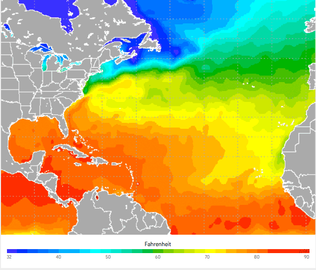
Sea Surface Temperature (°f): 86
Sargassum Forecast:
Latest observations show that a few sargassum mats continue to drift into the area. This is expected to continue during the next few days with moderate impacts on local beaches.
Outlook:
For Wednesday and Wednesday night is for a similar trend to occur.
Tropical Weather Outlook:
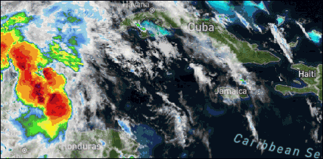
At 3:00am the center of tropical depression #3 was located near 19.6N latitude, 92.1W longitude or about 105mls west of Campeche, Mexico.
Click for more...
Marine Conditions:
The Caribbean Sea
...EXCESSIVE RAINFALL IN CENTRAL AMERICA AND MEXICO...
TD Three is part of a larger Central American Gyre circulation
that has been bringing heavy rainfall and flooding to portions
of Central America and southern Mexico during the past few days.
Additional heavy rainfall is expected over portions of southern
Mexico, Guatemala, El Salvador, Belize and Honduras. These rains
could lead to additional life-threatening flash floods and
mudslides, especially in areas of mountainous terrain over
portions of southern Mexico, El Salvador and Guatemala.
Scattered moderate to strong convection is occurring over much of
Central America and the the Gulf of Honduras in association with
the Central America Gyre. Elsewhere, scattered moderate
convection is over the SW Caribbean from eastern Panama to
northeast Nicaragua. Isolated trade wind showers are seen over
the central and eastern Caribbean. Fresh to strong winds prevail
over the Gulf of Honduras with 6 to 8 ft seas. Gentle to moderate
winds prevail over the eastern Caribbean with 4 to 6 ft seas, and
moderate to fresh winds prevail elsewhere with 5 to 7 ft seas.
The Central American Gyre, will persist over northern Central
America and southern Mexico during the entire week leading to
scattered showers and thunderstorms over the NW Caribbean.
Winds and seas will increase in the Gulf of Honduras and off
Yucatan through Sat as a result. The Bermuda High will rebuild
to north of the basin today, which will lead to the development
of fresh winds in the south-central Caribbean through Sat.
A flood alert is currently in effect and will continue for the remainder of the week, due to the remnants of Pacific Tropical Storm, Amanda, which crossed over the Central American isthmus over the weekend and dumped heavy rains over the area.
Rainfall over central and northwestern Belize between Saturday and today measured between 10 and 15 inches, causing flooding in vulnerable areas. Belmopan and areas along the Philip Goldson Highway were also inundated from Saturday morning.
Deputy Chief Meteorologist, Ronald Gordon says that the same general areas that have been affected by Amanda will continue to receive heavy showers, and the rains could also spread to other parts of the country as the system moves across to the Bay of Campeche and can likely redevelop. If that happens, Gordon says, it will assume the name Cristobal - the third Atlantic Storm name on this year's calendar.
Accuweather: Tropical Depression Three will bring heavy rainfall over southeast Mexico, the Yucatan Peninsula, Belize, Guatemala and parts of El Salvador and Honduras, with an AccuWeather Local StormMax� of 20 inches possible in some of the mountainous terrain of Central America. This heavy rainfall will cause life threatening flash flooding and higher terrain mudslides. By this weekend or early next week, as the storm moves northward, flooding concerns will escalate in the southern U.S.
For more information, check the daily Tropical Weather Outlook: click here
This storm is still rotating around the same area, just off the west side of the Yucatan, but sending out rotating arms from time to time. These brought rain over Belize last evening and again early this morning. Looks like it will hang around for a few days.
Looks as if it will remain cloudy for most of the day, with some rain in some locations from time to time.
Temperatures in Belmopan : ( Coast usually cooler, hills even cooler ) Last night min. 26°C 78°F Yesterday max. 33°C 91°F Yesterday Rain 16 mm ( 0.6")
2020 Hurricane Season begins with heavy rains across the region
The 2020 Atlantic Basin Hurricane Season officially began on Monday, June 1st, with torrential rains across the country.
On Ambergris Caye, it poured for hours, causing flooding in streets around San Pedro Town. Rain is expected to continue for the upcoming days, while the remnants of Amanda is heading to the Gulf of Mexico where it could become the season's third tropical storm.
Click here to read the rest of the article in the San Pedro Sun
Present Condition: Clouds with rain, especially in the north.Tropical Storm Cristobal declared over the Bay Of Campeche 24hr Forecast: Mostly cloudy with a few showers, periods of rain and isolated thunderstorms around the country today, then increasing mainly over the north tonight.
...DEPRESSION STRENGTHENS TO A TROPICAL STORM...
Observations from an Air Force Reserve Unit Hurricane Hunter aircraft indicate that Tropical Depression Three has strengthened into Tropical Storm Cristobal (pronounced krees-TOH-bahl). The maximum winds are estimated to be 40 mph (65 km/h) with higher gusts.
It's centered as of 11:15 a.m. CDT about 150 miles (245 km) west-southwest of Campeche, Mexico, moving toward the west-southwest at 3 mph (km/h).
===================== Depression strengthens to Tropical Storm Cristobal in the Bay of Campeche
As of Tuesday early afternoon EDT, Tropical Depression 3 has strengthened into Tropical Storm Cristobal. The storm continues to move very slowly in the Bay of Campeche, about 150 miles west-southwest of Campeche, Mexico. Maximum-sustained winds are near 40 mph. Cristobal is the third tropical storm to form in the basin this year.
Some further strengthening is expected during the next 24-48 hours, but interaction with land may impact how much it strengthens during this time. Tropical Storm Cristobal is expected to loop around near and over the southern coast of the Bay of Campeche Wednesday and Thursday, then slowly move northward Friday and this coming weekend, potentially bringing impacts to portions the Gulf Coast later this weekend or early next week. All interests along the central and western Gulf coast should start paying attention and consider taking action should the system approach the area.
Cristobal will continue to bring heavy rainfall over southeastern Mexico, the Yucatan Peninsula, Belize, Guatemala and parts of El Salvador and Honduras, with an AccuWeather Local StormMax&trade of 30 inches possible in some of the mountainous terrain of Central America. This heavy rainfall will cause life-threatening flash flooding and higher-terrain mudslides. By this weekend or early next week, as the storm moves northward, flooding concerns will escalate in the southern United States.
Elsewhere in the basin, there are no other tropical systems and none are expected to develop through at least the end of the week.
The storm is still circulating around the same western Yucatan, but it is sending another arm of rain towards Belize this evening, a small area already in north west Belize now, and sending arms of cloud and some rain in at us from the west. There has been heavy cloud with lightning, sitting almost still over the Belize north coastal area, including San Pedro most of the day, which must be having significant rain.
Bands from the system have been supporting persistent showers, periods of rain and thunderstorms over the Belize City and surrounding areas...
FLOOD REPORT AND FORECAST Tuesday June 2, 2020
River Conditions
REGION 7: The Blue Creek Sub catchment of the RIO HONDO is flooded, flood levels have exceeded the historical levels recorded for Hurricane Mitch.
The NEW RIVER is continues to rise slowly but remains below the banks.
REGION 9: On the MACAL RIVER, reservoir levels remain below the spillways at Chalillo, Mollejon and Vaca facilities. At San Ignacio, levels remains below the low level bridge but is gradually rising. The MOPAN RIVER at Benque Viejo Town has exceeded its banks and continues to rise. On the BELIZE RIVER, river levels at Banana Bank has crest at a high of 3.89 and is falling. The CROOKED TREE LAGOON is below the causeway and rising. At Double Run, levels are steadily rising. On the HAULOVER CREEK near Chetumal Street Bridge, levels are normal and steady. On the BURDON CANAL normal and steady levels exists.
REGION 11: The SIBUN RIVER near Freetown Sibun is in flooded and has exceeded its banks. On the Coastal Road the bridge near La Democracia, is impassable of due to flood waters. Levels are steady on the SOUTHERN LAGOON near Gales Point Village. The SITTEE RIVER at Kendal Bridge is steady. The RIO GRANDE is normal steady.
REGION 13: The TEMASH RIVER near Crique Sarco is steady. FLOOD FORECAST -24 HOURS
REGION 7 - The Rio Hondo is expected to continue to rise at Blue Creek and downstream at San Roman, Santa Cruz and Douglas. The New River is expected to increase slowly.
REGION 9 - The Mopan will continue to increase slowly. The Macal will continue increase gradually Banana Bank flood levels continue to falling becoming steady later today. On Lower Belize River, lagoon levels will continue to rise at Crooked Tree. Double Run will approach bankfull stage.
Region 11 - Sibun River will continue to rise at Democracia and Freetown REGION 13 - Normal levels are espected.
Heavy Rains Result in Flash Floods!
Heavy rains over the weekend resulted in flash floods in a number of countries where deaths were recorded in El Salvador, Guatemala and Honduras. According to the National Met Service, Belize experienced upwards of ten inches of rainfall as a result of a low pressure system that passed over the country. The heavy downpour on Friday night caused flooding in Mahogany Heights, Saint Matthew's Village and other areas with flood waters covering portions of the George Price Highway. Tonight, those flood waters have displaced thirteen adults and thirteen children who are now in a shelter in Saint Matthew's village. On Saturday, residents reported that they experienced ten hours of heavy rains on Friday night which washed away crops, chickens and other belongings. Here's the story.
The opinions and views expressed on this board are the subjective opinions of Ambergris Caye Message Board members and not of the Ambergris Caye Message Board its affiliates, or its employees.


 General Situation:


![[Linked Image]](http://Ambergriscaye.com/art8/belmopanwx200602.jpg)
![[Linked Image]](http://Ambergriscaye.com/art8/Belize-Hurricane-2020-Season-1-657x493.jpg)
![[Linked Image]](http://Ambergriscaye.com/art8/dailywx200602b.jpg)
![[Linked Image]](http://Ambergriscaye.com/art8/101512824_3194984040567054_8411159803824439296_ox.jpg)
![[Linked Image]](http://Ambergriscaye.com/art8/CAA9641C-9A5C-41B2-90C2-9F935A5BFC66.jpg)


