General Situation:
Ambergris Caye: Conditions this morning by Elbert just before or after this post!
Belize NMS:
Present Condition: Mostly cloudy this morning, heavy rain in the south. Generally fair weather will prevail today.
Advisories: *Residents are advised to remain alert for possible flooding in southern districts, especially Toledo. Residents, especially those inland, are advised to stay hydrated and to avoid direct sunlight as much as possible. *
24-hour forecast:
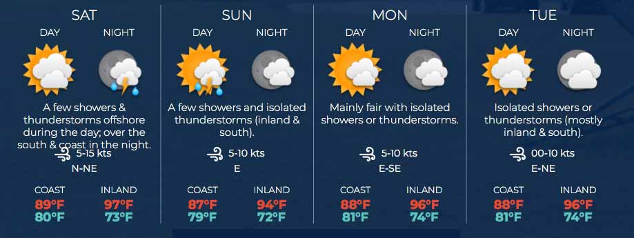
Mostly sunny today and partly cloudy tonight. Showers or thunderstorms will be isolated, except for a few more occurring over the south late tonight.
Winds: E-NE, 5-10 kts Sea State: Light Chop-Choppy
Waves: 2-4 ft.
Sea Surface Temperature (°f): 87
Outlook:
For Saturday and Saturday night is for a few showers and thunderstorms offshore, likely reaching the south and coast late afternoon and in the night.
Sargassum Forecast from July 28, 2020 to August 04, 2020:
Several Sargassum mats were observed, especially over central and northern coastal areas, during the past few days. Therefore, there is a high chance of sargassum mats affecting local beaches in the coming days. San Pedro has a high probability and a major expected impact.
Tropical Weather Outlook:
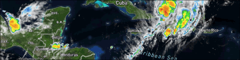
At 6:00 am Hurricane Isaias was centred near 21.3N, 73.9W, or about 30 miles NW of Great Inagua Island.
Click for more...
Marine Conditions:
The Caribbean Sea
A Caribbean Sea tropical wave is along 85W/86W, from 20N
southward, moving W 20 knots. The wave is passing through parts
of Honduras, Nicaragua, and the westernmost sections of Costa
Rica. Precipitation: isolated moderate to locally strong is
within 60 nm of the coast of Honduras, along the tropical wave.
The monsoon trough is along 08N/10N, from Colombia along 74W
westward, to the coastal waters of Central America from
Nicaragua southward. Precipitation: isolated moderate is from
13N southward from 75W westward, in the SW corner of the
Caribbean Sea.
Tropical Storm Isaias near 20.5N 71.9W 999 mb at 0300 UTC moving
NW at 16 kt. Maximum sustained winds 50 kt gusts 60 kt. Isaias
will continue NW and reach the central Bahamas near
23.5N 76.1W Fri evening; then continue NNW through the NW
Bahamas and near SE Florida and reach hurricane strength near
26.7N 79.0W on Sat evening, before moving N and away from the
region through Monday. Tropical storm conditions and large seas
will prevail tonight in the Windward Passage. Fresh to strong
wind flow will persist to the south of Hispaniola into Friday.
On Ambergris Caye this morning the breeze is from the Northeast at 15 mph and the sea around our Barrier Reef is calm. nice weather. The high temperature should be 86 f.
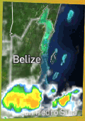
We are still in the thick of it, but not as thick as yesterday. There are several small swellups down south, mainly just off shore, causing some heavy rain patches. The Caribbean winds are from the NE this morning, couuld get hearier in patches, so could cause the odd rain shower in any place this morning.
Temperatures in Belmopan : ( Coast usually cooler, hills even cooler ) Last night min. 26°C 78°F Yesterday max. 33°C 91°F Yesterday Rain 1.1 mm ( 0")
It's still shocking to see this much parking in the town's HOT SPOTS. This was at noon! Photo by San Pedro Scoop
The rain in Toledo is now on land and slowly moving northwards, but the lightning in it is dying out, so presumably the amount of rain is reducing now. Presently no indication of rain elsewhere.
Present Condition: A few scattered clouds in the north, cloudier in the south. Generally fair weather prevails. 24hr Forecast: Between Saturday afternoon and Sunday midday is for a few showers and isolated thunderstorms mainly along the coast. Residents, especially those inland, are advised to stay hydrated and to avoid direct sunlight as much as possible.
Live Beach Cam at Blue Water Grill
Monthly Weather Summary, July 2020
National Meteorological Service of Belize
July, on average, is the second wettest month of the year for the country of Belize. Systems that affect the country during this month normally include tropical waves, tropical upper tropospheric troughs (TUTTs) and occasionally tropical cyclones.
Relatively moist and unstable conditions prevailed at the beginning of July 2020 as a tropical wave approached on the 1st and crossed the country during the morning of the 2nd. Isolated showers and thunderstorms affected inland and some central areas during the daytime on the 1st then a few showers and thunderstorms occurred over most areas during the night and persisted through to the 2nd morning. The activity resumed later that night and continued on the 3rd especially over the Cayo and Orange Walk districts during the morning, then over the extreme south overnight. Conditions remained moist and unstable on the 4th as another tropical wave moved over the area and supported thunderstorm activity over the Belize district in the morning and over inland areas in the afternoon then over southern areas during the night.
Generally fair conditions prevailed over most of the country from the 5th through to the 7th as the Atlantic High Pressure Ridge supported a moderate easterly to southeasterly surface flow. As a result, only isolated thunderstorms and isolated showers developed mainly over the Toledo district. A weak tropical wave crossed the country during the afternoon of the 8th but this did not produce any significant rainfall so conditions remained warm and mostly dry. Except for isolated afternoon thunderstorms and showers over the northwest part of the Orange Walk district on the 9th mainly fair, warm and dry conditions prevailed. Tropical Storm Fay formed near the eastern coast of the United States around mid-afternoon.
A tropical wave crossed the country early on the 10th supporting a few showers inland during the daytime then showers and thunderstorms affected mostly the south later that night through to the early morning of the 11th. Both automatic weather stations in Punta Gorda recorded 4.5 inches of rainfall between midnight and 6 am on the 11th. Mainly fair weather prevailed the remainder of the 11th through to the 12th then another tropical wave moved across the country around midnight on the 13th supporting a few showers and thunderstorms over the south during the morning then the activity increased over the Toledo district during the night. Punta Gorda received 142.2 mm (5.59 inches) of rainfall that resulted in localized flooding on the 14th morning. Showers and thunderstorms remained mostly offshore during the morning of the 14th and affected the cayes then isolated thunderstorms and showers developed over inland and southern areas during the afternoon and night.
A moderate easterly to northeasterly airflow prevailed on the 15th as a weak tropical wave crossed the country during the early morning hours. This wave did not generate any significant rainfall, so showers remained isolated from the 15th to the 16th.
A tropical upper tropospheric trough (TUTT) supported an increase in upper level divergence and moisture on the 17th which resulted in relatively moist and unstable conditions over the area. Showers and thunderstorms affected mainly coastal and northern areas of the country during the daytime then mostly the Toledo district during the night. Moisture increased further on the 18th as a tropical wave approached and supported thunderstorms and periods of rain mainly along the coast and over southern districts in the morning then isolated thunderstorms developed over the Orange Walk and Cayo districts in the afternoon.
Relatively dry conditions prevailed from the 19th to the 21st over much of the country. Showers and thunderstorms were isolated and occurred mostly inland during the afternoons and over the south during the nighttime hours. This was followed by a brief increase in moisture on the 22nd due to passage of a tropical wave coupled with favorable conditions at the upper levels. This supported the development of some showers and a few thunderstorms in the south during the night. Tropical Depression Eight formed over the Gulf of Mexico later that evening.
The 23rd saw only isolated thunderstorms developing over northern and western portions of the country. Tropical Depression Eight strengthened into Tropical Storm Hanna. Mainly fair and warm conditions prevailed on the 24th even though another weak tropical wave moved over the area.
Conditions remained generally fair and warm on the 25th with only isolated showers or thunderstorms inland during the afternoon time and over the south at night. Another weak tropical wave crossed over the area late on the 26th and supported a few showers and thunderstorms mostly over southern Belize. The weather stations in Punta Gorda recorded 15.0 mm (0.59 inches) and 13.2 mm (0.52 inches) of rainfall.
A fresh to gusty easterly airflow prevailed on the 27th and supported mainly fair and warm conditions across the country. Except for isolated thunderstorms over the Maya mountains and isolated showers over central areas, rainfall activity was minimal. Similar weather prevailed on the 28th except for isolated thunderstorms over the Orange Walk district during the evening.
Another tropical wave crossed the country during the early morning hours of the 29th supporting an increase in moisture and instability resulting in a few showers and thunderstorms over the south at first then especially over the northern districts in the afternoon. The activity persisted throughout the night and into the morning of the 30th mainly over southern and central areas of the country then spreading to northern areas during the afternoon.
The last tropical wave for the month of July 2020 moved across the country during the early morning of the 31st with no significant convective activity as generally fair weather prevailed across the country with only isolated showers and an isolated afternoon thunderstorm along the southwest border.
Twelve tropical waves crossed the country in July 2020, these were mostly weak and as a result rainfall was well below normal across the country. The graph and maps below summarize the total rainfall and average maximum and minimum temperature recorded during the month of July 2020. They also give an indication of how these readings compare to the normal for the month across the stations sampled. As can be seen, rainfall was below normal for the entire country during the month. In terms of maximum/daytime temperatures, all of the stations show daytime temperatures were warmer than normal during July 2020. Minimum/nighttime temperatures were near normal at Towerhill in the north and at Savannah in southern Stann Creek, and above normal over the rest of the country, except for Central Farm and Punta Gorda where nighttime temperatures were slightly cooler than normal for the month.
Monthly Rainfall Summary
Monthly Maximum Temperatures
Monthly Minimum Temperatures
Rainfall Observed: January 2020 (mm)
Rainfall Observed: January 2020 (% Above/Below Average)
The opinions and views expressed on this board are the subjective opinions of Ambergris Caye Message Board members and not of the Ambergris Caye Message Board its affiliates, or its employees.


 General Situation:


![[Linked Image]](http://Ambergriscaye.com/art8/belmopanwx200731.jpg)
![[Linked Image]](http://Ambergriscaye.com/art8/116442700_4174292515945584_2334143584996267649_o.jpg)
![[Linked Image]](http://Ambergriscaye.com/art8/pcbjpncppkhpbphh.jpg)
![[Linked Image]](http://Ambergriscaye.com/art8/dailywx200731b.jpg)
![[Linked Image]](http://Ambergriscaye.com/art8/2020july1.jpg)
![[Linked Image]](http://Ambergriscaye.com/art8/2020july2.jpg)
![[Linked Image]](http://Ambergriscaye.com/art8/2020july3.jpg)
![[Linked Image]](http://Ambergriscaye.com/art8/2020july4.jpg)
![[Linked Image]](http://Ambergriscaye.com/art8/2020july5.jpg)


