General Situation:
Ambergris Caye: Conditions this morning by Elbert just before or after this post!
Belize NMS:
Present Condition: Very cloudy this morning. Moist and relatively unstable conditions prevail.
Advisories: *A Small Craft Warning is in effect for coastal waters of the country. Operators of small crafts should seek safe harbor. A Flood Warning is in effect for the Belize, Cayo, Stann Creek and Toledo Districts. Residents in the Belize River Valley and downstream to the coast should remain vigilant as the rising flood waters move downstream to the coast.*
24-hour forecast:
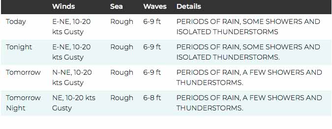
Mostly cloudy to overcast skies with periods of rain, which will be continuous over some places, some showers and a few thunderstorms today and tonight.
Winds: NE, 10-20 kts , Gusty Sea State: Rough
Waves: 6-9 ft
Sea Surface Temperature (°f): 84
Outlook:
Mostly cloudy to overcast skies with periods of rain, a few showers and thunderstorms mainly over northern, central and southern areas Friday and Friday night.
Sargassum Forecast from November 17, 2020 to November 25, 2020:
Sargassum impacts over our area remain low and no major change is expected during the new few days. San Pedro has a low probability and a minimal expected impact.
Tropical Weather Outlook:
A broad area of low pressure has formed over the southwestern Caribbean Sea and has a low chance of development over the next couple of days.
Click for more...
Marine Conditions:
The Caribbean Sea
A broad area of low pressure located over the southwestern
Caribbean Sea and is producing an area of disorganized showers and
thunderstorms. Development, if any, of this system is expected to
slow to occur during the next several days while it drifts
west-southwestward or westward across the southwestern Caribbean
Sea.
Elsewhere, a 1011 mb low pressure area is noted in the southwest
Caribbean north of the Panama Canal near 11N80W. Scattered
moderate and isolated strong disorganized convection is noted
within 180 nm in the southeast semicircle of the low. Development,
if any, of this system is expected to slow to occur during the
next several days while it drifts west-southwestward or westward
across the southwestern Caribbean Sea. Regardless of tropical
cyclone formation, areas of heavy rain are possible during the
next several days from Nicaragua southward across Central America
and into Colombia. These rains could cause new flooding concerns,
especially across previously inundated areas. Please read the
latest Tropical Weather Outlook issued by the National Hurricane
Center at website www.nhc.noaa.gov/text/MIATWOAT.shtml for more
details.
Scattered moderate convection is noted in the Gulf of Honduras
extending southeastward to offshore of Honduras and Nicaragua.
Additional scattered moderate convection is noted in the central
Caribbean between 68W-72W due to a mid-to-upper level trough.
Moderate to fresh trades and seas of 4-6 ft are noted east of 72W,
with mainly moderate trades W of 72W, except moderate to fresh
south of 18N.
The fresh to strong winds in the northwest Caribbean will
gradually diminish this weekend. Moderate to fresh trades will
prevail across the remainder of the basin through the weekend,
weakening some early next week as the pressure gradient slackens.
A broad area of low pressure located over the southwestern Caribbean Sea and is producing an area of disorganized showers and thunderstorms. Development, if any, of this system is expected to slow to occur during the next several days while it drifts west-southwestward or westward across the southwestern Caribbean Sea. Regardless of tropical cyclone formation, areas of heavy rain are possible during the next several days from Nicaragua southward across Central America and into Colombia. These rains could cause new flooding concerns, especially across previously inundated areas. * Formation chance through 48 hours...low...near 0 percent. * Formation chance through 5 days...low...10 percent.
A non-tropical area of low pressure could form between the Bahamas and Bermuda by early next week. The system could gradually develop subtropical characteristics through the middle of next week while it moves northeastward. * Formation chance through 48 hours...low...near 0 percent. * Formation chance through 5 days...low...20 percent.
For further information on tropical conditions, check the daily Tropical Weather Outlook, click here
To find out more about the overall weather conditions, we got an update from Chief Meteorological Officer Ronald Gordon. He says that while the system associated with Hurricane Iota continues to drift away, the next few days will be wet as the country experiences some rains.
On the Phone: Ronald Gordon, Chief Meteorological Officer
"We expect conditions to continue relatively moist and unstable across the country. The remnants of former Hurricane Iota has dissipated and is moving across Salvador into the Pacific Ocean. However, we have a moist south-easterly flow behind it which will keep relatively wet conditions and we expect some few showers, periods of rains and isolated thunderstorms to persist throughout the weekend."
Andrea Polanco
"What are we expecting in terms of inches in rainfall?"
On the Phone: Ronald Gordon
"We are estimating about two to four inches of rainfall between now and Thursday and then it will taper off to about one inch per day, a maximum across the country."
Andrea Polanco
"For those out at sea or out in the cayes anything they can look out for?"
On the Phone: Ronald Gordon
"We have a small craft warning still in effect. We are advising operators of small craft to remain in safe harbor. Winds are still gusting at fifteen to twenty-five knots of higher gusts and we expect that to continue through tomorrow before the winds start to die off.
We want to alert residents to be on the lookout especially if they live in flood prone areas, if you need to evacuate you should do so and for those out at sea, mariners, we advise them to remain in safe harbors and don't venture out in the sea."
On Ambergris Caye this morning we have rain and some minor flooding. According to the Almost Official North Ambergris Udometer last night and this morning's rain measures to be almost 4 inches. The wind is from the NE at 20 mph. Advisories: *A Small Craft Warning is in effect for the coastal waters of the country. Operators of small crafts should seek safe harbor.
The storm has gone, but we are in the middle of a battle ground left behind by it. The Caribbean easterly winds, with cloud are fighting their way back in, pushing away that earlier cool air from the north, back up into the Gulf, and the Pacific high level, that was partly responsible for that storm, is pushing against the Caribbean winds. The result is a line of battle ( orange dotted line ) right down the Yucatan and Belize, resulting in a lot of rain and swellup activity.
Looks as if most of Belize will be under low cloud and high cloud, most of the day, causing many outbreaks of rain.
Temperatures in Belmopan : ( Coast usually cooler, hills even cooler ) Last night min. 23°C 73°F Yesterday 25°C 77°F Yesterday Rain 66 mm ( 2.6")
Present Condition: Very cloudy throughout the country. Moist and unstable conditions persist over the area.
24hr Forecast: Cloudy with sunny breaks this afternoon then mostly cloudy tonight and tomorrow morning. Some showers, periods of rain and isolated thunderstorms will occur especially over northern and central areas.
A flood warning is in effect for low lying and flood prone areas of the country due to heavy rainfall. Residents in the Belize River Valley and downstream should remain vigilant as the rising flood waters move downstream towards the coast. A small craft warning remains in effect for coastal waters of the country. Operators of small crafts should remain in safe harbour.
Outlook: Some showers, periods of rain and isolated thunderstorms will continue to affect mostly northern and central areas Friday afternoon, increasing over most areas Friday night and Saturday morning.
Current Situation - Light flooding in areas of Corozal Town. Some rural areas may be experiencing far worse conditions. Photos by the Corozal Daily
The Rio Hondo has risen significantly woth the ongoing rains. At this point the meter that measures the water level will soon be submerged under the river.
The opinions and views expressed on this board are the subjective opinions of Ambergris Caye Message Board members and not of the Ambergris Caye Message Board its affiliates, or its employees.


 General Situation:


![[Linked Image]](http://Ambergriscaye.com/art8/dasdakkkkk459.jpg)
![[Linked Image]](http://Ambergriscaye.com/art8/hurricaneoutlook201119.jpg)
![[Linked Image]](http://Ambergriscaye.com/art8/hurricaneglobe201119.jpg)


![[Linked Image]](http://Ambergriscaye.com/art8/belmopanwx201119.jpg)
![[Linked Image]](http://Ambergriscaye.com/art8/mdbcafdamjfckiai.jpg)
![[Linked Image]](http://Ambergriscaye.com/art8/cnmcekkcbdpbcnfi.jpg)
![[Linked Image]](http://Ambergriscaye.com/art8/dailywx201119b.jpg)
![[Linked Image]](http://Ambergriscaye.com/art8/125359554_2733089473574077_2179421639094632043_o.jpg)
![[Linked Image]](http://Ambergriscaye.com/art8/126348246_2733089446907413_3806761869522465711_n.jpg)
![[Linked Image]](http://Ambergriscaye.com/art8/125376104_2733089440240747_5939839923570340774_n.jpg)
![[Linked Image]](http://Ambergriscaye.com/art8/125511085_2733089493574075_3814143866148513311_n.jpg)
![[Linked Image]](http://Ambergriscaye.com/art8/126537766_2733089503574074_3720379185652514854_n.jpg)
![[Linked Image]](http://Ambergriscaye.com/art8/125543660_2733089533574071_7554642511005969943_n.jpg)
![[Linked Image]](http://Ambergriscaye.com/art8/125470806_2733089560240735_2113202059868517994_n.jpg)
![[Linked Image]](http://Ambergriscaye.com/art8/125979696_2733089570240734_2155190570211366764_n.jpg)
![[Linked Image]](http://Ambergriscaye.com/art8/126356276_3851179671582436_8591014124222427412_n.jpg)
![[Linked Image]](http://Ambergriscaye.com/art8/125834101_3851179778249092_205248862330980388_n.jpg)
![[Linked Image]](http://Ambergriscaye.com/art8/125782201_3851179804915756_4341973625922862185_n.jpg)
![[Linked Image]](http://Ambergriscaye.com/art8/126092374_3851179921582411_6416730766904870876_n.jpg)
![[Linked Image]](http://Ambergriscaye.com/art8/126169044_3851179678249102_1277844765916761062_n.jpg)
![[Linked Image]](http://Ambergriscaye.com/art8/125838482_126222995957774_3198586373915545119_n.jpg)
![[Linked Image]](http://Ambergriscaye.com/art8/125796022_126223069291100_2995536967420891270_n.jpg)
![[Linked Image]](http://Ambergriscaye.com/art8/125979693_126223105957763_91353961132218370_n.jpg)
![[Linked Image]](http://Ambergriscaye.com/art8/126808004_126223045957769_7198564802666092630_n.jpg)
![[Linked Image]](http://Ambergriscaye.com/art8/125997577_126223122624428_787164972709666877_n.jpg)
![[Linked Image]](http://Ambergriscaye.com/art8/125567557_126223175957756_7284027170462126231_n.jpg)
![[Linked Image]](http://Ambergriscaye.com/art8/125881297_126223222624418_8773977417686724838_n.jpg)
![[Linked Image]](http://Ambergriscaye.com/art8/126093524_126223205957753_7541411167437837511_n.jpg)
![[Linked Image]](http://Ambergriscaye.com/art8/125296113_126223029291104_4568871633143003760_n.jpg)
![[Linked Image]](http://Ambergriscaye.com/art8/125835584_126223155957758_4956943189962282231_n.jpg)
![[Linked Image]](http://Ambergriscaye.com/art8/125562144_126223085957765_1499560080655194258_n.jpg)
![[Linked Image]](http://Ambergriscaye.com/art8/125808287_126223012624439_7196928294364348841_n.jpg)


