General Situation:
Ambergris Caye: Conditions this morning by Elbert just before or after this post!
Belize NMS:
Present Condition: A slight increase in moisture is expected tonight.
Advisories: None.
24-hour forecast:
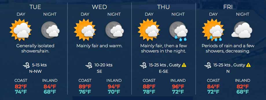
A cold Koopt� front will reach the Yucatan peninsula today, generating rain, and refreshing temperatures. Sunny with a few cloudy spells today becoming mostly cloudy tonight. Shower activity will be isolated today; then a few showers and periods of rain will affect mainly inland and northern areas tonight spreading to coastal areas by morning.
Winds: E-SE, 10-20 kts Sea State:
Light chop
Waves: 2-4 ft.
Sea Surface Temperature (°f): 81
Outlook:
Periods of light rain and a few showers will affect mostly coastal areas on Tuesday gradually decreasing and become isolated by Tuesday night.
Sargassum Forecast from February 9 to February 17:
Sargassum impacts are expected to remain moderate during the coming days with the chance of a few mats drifting onto local beaches. San Pedro has a medium probability and a moderate expected impact.
Tropical Weather Outlook:
There are no organized tropical features across the Atlantic basin at this time. Updates will resume at the beginning of the 2021 hurricane season (June 1).
Click for more...
Marine Conditions:
The Caribbean Sea
A Gale Warning has been issued for the south-central Caribbean.
See the Special Features section for details. Recent scatterometer data depicts moderate to fresh trade winds
across most of the central and eastern parts of the basin, with
mainly moderate winds in the western portion of the basin. Fresh
to strong winds are likely still occurring south of Hispaniola
to Colombia and western Venezuela. Seas are estimated to be 6 to
9 ft over the eastern and central Caribbean, with 4 to 6 ft in the
northwest Caribbean. High pressure north of the area is allowing
for dry conditions to prevail, aside from scattered fast-moving
showers embedded in the trade wind flow in the central Caribbean.
The high pressure north of the area will maintain fresh
to strong trade winds across the central and eastern Caribbean
through the middle of this week. SE winds will increase to strong in
the Gulf of Honduras on Wed night/early Thu also as a strong cold
front approaches from the Gulf of Mexico. The cold front is
expected to enter the NW Caribbean Fri, with strong N winds behind
the front. Large north swell will continue to affect the tropical
N Atlantic waters, to the east of the Lesser Antilles, through
the middle of this week.
Good Morning Belize!! A healthy mangrove ecosystem equals a healthy fish population!! Photo by Hol Chan Marine Reserve
The Caribbean winds are still being deflected up to the north by the air coming up from the south. But there is something else happening. I suspect a cool air bubble is coming in from the NW concealed under the high level cloud. This may show more activity later today.
Looks as if today will be mainly sunny, largely clear skies, some cloud developing later, presently, no indication of any rain.
Temperatures in Belmopan : ( Coast usually cooler, hills even cooler ) Last Night 24°C 75°F Yesterday 31°C 88°F Yesterday Rain 0 mm ( 0")
Present Condition: Fair weather prevails. An increase in moisture and showery activity is expected overnight.
24hr Forecast: Mostly sunny this afternoon, with increased cloudiness expected tonight and tomorrow morning. A few showers and periods of rain will begin mainly over northern and inland areas tonight, before spreading to affect coastal areas late tonight and into tomorrow morning.
Outlook: For Tuesday afternoon is for a few showers or periods of light rain over some areas of the country. Then, Tuesday night and Wednesday morning will see generally fair weather with only isolated showers.
REGION 7 - On the RIO HONDO at Blue Creek, Santa Cruz, San Antonio, San Roman and Douglas, levels are near normal and steady. On the NEW RIVER at Tower Hill and Caledonia levels are above normal and steady.
REGION 9 - On the MACAL RIVER reservoir levels at Chalillo and Vaca facilities are below the spillway; the Mollejon facility began spilling earlier this morning, while at San Ignacio; levels remains below the low-level bridge and steady. Levels on the MOPAN RIVER at Benque Viejo Town are above normal and falling.
The BELIZE RIVER at Double Run is above normal and falling. The CROOKED TREE LAGOON is above normal and continues to fall.
REGION 11 - Levels on the SIBUN RIVER at Freetown Sibun is near normal and has increased minimally. Levels on the SOUTHERN LAGOON near Gales Point Village is near normal and steady. The watersheds on the EASTERN SLOPES OF THE MAYAN MOUNTAINS are normal and steady. The SITTEE RIVER at Kendal Bridge is near normal and steady. The Swasey and Blades branches of the MONKEY RIVER are near normal and steady. Levels on the DEEP RIVER at Medina Bank are below normal and steady. Levels on the RIO GRANDE at San Pedro Columbia and Big Falls South are below normal and steady. On the MOHO RIVER at Blue Creek South and Jordan levels are near normal and steady. On the TEMASH RIVER near Crique Sarco levels are below normal and steady.
REGION 13 - On the SARSTOON RIVER levels are normal and steady.
FLOOD FORECAST
REGION 7 - On the RIO HONDO at Blue Creek, Santa Cruz, San Antonio, San Roman and Douglas to the coast, a minimal increase in river levels is expected. On the NEW RIVER at Tower Hill and Caledonia, a minimal increase in river levels is expected.
REGION 9 - On the MACAL RIVER, reservoir levels are expected to remain below the spillway at the Chalillo and Vaca facilities, and at the Mollejon facility reservoir levels are expected to remain above the spillway; at San Ignacio, levels are expected to remain below the low-level bridge. On the MOPAN RIVER at Benque Viejo Town, levels are expected to increase minimally.
On the BELIZE RIVER at Double Run, an increase in river levels is expected. On the CROOKED TREE LAGOON, levels are expected to become steady.
REGION 11 - On the SIBUN RIVER at Freetown Sibun, levels are expected to decrease to below normal levels. On the SOUTHERN LAGOON near Gales Point, no significant change is expected. In watersheds on the EASTERN SLOPES OF THE MAYAN MOUNTAINS, normal and steady levels are expected. On the SITTEE RIVER, at Kendal Bridge no significant change is expected. On the Swasey and Bladen branches of the MONKEY RIVER, levels are expected to become normal. On the DEEP RIVER at Medina Bank no significant change is expected. On the RIO GRANDE at San Pedro Columbia and Big Falls South no significant change is expected. On the MOHO RIVER at Blue Creek South and Jordan, levels are expected to become normal. On the TEMASH RIVER near Crique Sarco levels are expected to become normal.
REGIONS 13 - On the SARSTOON RIVER, no significant change is expected over the next few days.
The next Flood Report and Forecast will be issued on Friday February 19, 2021 at 12 pm
The opinions and views expressed on this board are the subjective opinions of Ambergris Caye Message Board members and not of the Ambergris Caye Message Board its affiliates, or its employees.


 General Situation:


![[Linked Image]](http://Ambergriscaye.com/art8/149280611_3580235328764199_1028893523025839056_o.jpg)


![[Linked Image]](http://Ambergriscaye.com/art8/dailywx210215b.jpg)
![[Linked Image]](http://Ambergriscaye.com/art8/dailywxB210215.jpg)
![[Linked Image]](http://Ambergriscaye.com/art8/dafoohommnghaifa.jpg)


