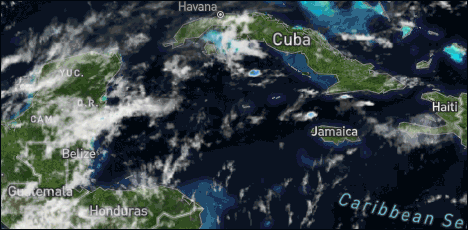
General Situation:
Ambergris Caye: Conditions this morning by Elbert just before or after this post!
Belize NMS:
Present Condition: Mostly cloudy skies this morning. Partly cloudy and windy in San Pedro. Fair and warm weather prevailing.
Advisories: None.
24-hour forecast:
Today skies will be mostly sunny, tonight skies will be partly cloudy. Shower activity will be isolated.
Winds: E, 5-15 kts Sea State:
Light Chop
Waves: 2-4 ft.
Sea Surface Temperature (°f): 84
Outlook:
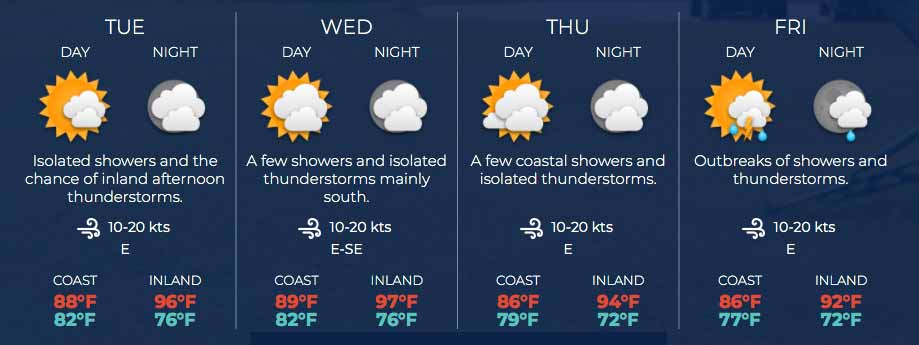
For Tuesday and Tuesday night is for partly cloudy skies with isolated showers and the chance of inland afternoon thunderstorms developing.
Sargassum Forecast from May 11 to May 19:
Satellite imagery continue to show an abundance of Sargassum over the northwest Caribbean Sea. It is very likely that some of these mats could make their way to coastal areas, especially over central and northern parts of the country. San Pedro has a high probability and a major impact.
Tropical Weather Outlook:
Tropical cyclone formation is not expected in the North Atlantic, the Caribbean Sea or the Gulf of Mexico during the next 48 hours.
Click for more...
Marine Conditions:
Live Beach Cam at Blue Water Grill
The Caribbean Sea
Atlantic high pressure is centered across the NE Atlantic and
extends W-SW and weakly across the W Atlantic north of the area.
This is producing a modest pressure gradient, and supporting fresh
to locally strong tradewinds across the southern Caribbean south
of 15N between 64W and 77W, where seas are 5 to 7 ft. Stable
atmospheric conditions associated with the western side of an
upper level trough continue to produce generally fair weather
east of 80W. A low to mid level trough to the south of 13N is
moving across the Windward Islands this morning and will bring
tropical moisture with scattered showers and a few thunderstorms
across the SE Caribbean today and tonight.
The monsoon trough passes through Colombia near 11N74W across
Panama and into the eastern Pacific Ocean. Scattered moderate
convection is noted south of 10N across the Gulf of Uraba and
adjacent waters of Panama east of 79W.
Atlc high pressure ridge NE of the area will shift eastward and
weaken, diminishing winds and seas modestly across the basin through
Wed. Trade winds will increase basin wide Wed night through Fri
night as high pressure builds across the W Atlc.
In these two temperature maps of the Atlantic Ocean, we can see the similarity between May 2020 temperatures and the current temperatures of May 2021.
We remember that in 2020 ocean temperatures played a very important role in the exaggerated formation of storms, this year a similar scenario is seen as regards temperatures.
On Ambergris Caye this morning we have a 15 mph wind from the East creating calm sea conditions around our barrier reef. Today's expected high temperature for the day is set at 88 f.
The high level clouds from the SW are dominating our weather this morning, forming 80% of the cloud over us at present. The regular easterly Caribbean winds also have some clouds with them, particularly over the Toledo area.
Looks as if today will have more high level cloud than typical, and significant low cloud, but slow chance of rain, higher chance in the south.
Temperatures in Belmopan : ( Coast usually cooler, hills even cooler ) Last Night 24°C 75°F Yesterday max. 33°C 91°F Yesterday Rain 0 mm ( 0")
Possibly some cloud build-ups along the western border later.
Present Condition: Mostly clear skies throughout the country. Sunny skies and windy in San Pedro. Mainly fair conditions will prevail during the next 36-48 hours.
24hr Forecast: Sunny with a few cloudy spells during the daytime and clear to partly cloudy tonight. Showers will be isolated.
Outlook: Tuesday afternoon through midday Wednesday: Mainly fair conditions will continue with the chance for isolated afternoon thunderstorms over inland areas.
The opinions and views expressed on this board are the subjective opinions of Ambergris Caye Message Board members and not of the Ambergris Caye Message Board its affiliates, or its employees.


 General Situation:


![[Linked Image]](http://Ambergriscaye.com/art8/187548660_2905208443088913_5650088840235035641_n.jpg)


![[Linked Image]](http://Ambergriscaye.com/art8/bdikikimklkflahm.jpg)
![[Linked Image]](http://Ambergriscaye.com/art8/dailywx210517b.jpg)
![[Linked Image]](http://Ambergriscaye.com/art8/dailywxB210517.jpg)
![[Linked Image]](http://Ambergriscaye.com/art8/187574689_5512523712122451_6456526582924467095_n.jpg)
![[Linked Image]](http://Ambergriscaye.com/art8/186564261_1198738600585858_2832486534546118911_n.jpg)
![[Linked Image]](http://Ambergriscaye.com/art8/187603892_4155831074536881_6117674279133620266_n.jpg)
![[Linked Image]](http://Ambergriscaye.com/art8/187342446_4155831317870190_7048001495076569204_n.jpg)
![[Linked Image]](http://Ambergriscaye.com/art8/186558413_4155831204536868_1135174689642726475_n.jpg)
![[Linked Image]](http://Ambergriscaye.com/art8/186506424_10225045399340111_8422748652319601434_n.jpg)
![[Linked Image]](http://Ambergriscaye.com/art8/186564147_140692991414641_2480233303456158202_n.jpg)


