General Situation:
Ambergris Caye: Conditions this morning by Elbert just before or after this post!
Belize NMS:
Present Condition: Fairly cloudy on the mainland, clear in the NE quadrant. Mostly sunny and windy in San Pedro. Relatively moist easterly airflow persist over the area.
Advisories: None.
24-hour forecast:
Cloudy spells with a few showers and isolated thunderstorms.
Winds: E, 5-15 kts Sea State:
Choppy
Waves: 3-5 ft.
Sea Surface Temperature (°f): 85
Outlook:
A few showers and isolated thunderstorms will continue to affect the country on Thursday and Thursday night.
Sargassum Forecast from June 1 to June 9:
The threat of sargassum affecting beaches will remain high during the next few days as satellite imagery continue to show several areas with sargassum offshore. San Pedro has a high probability and a moderate impact.
Tropical Weather Outlook:
Tropical cyclone formation is not expected in the North Atlantic, the Caribbean Sea or the Gulf of Mexico during the next 48 hours.
Click for more...
Marine Conditions:
Live Beach Cam at Blue Water Grill
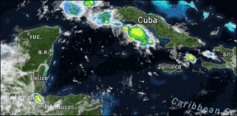
The Caribbean Sea
There will be a broad trough of low pressure in the SW Caribbean
later this week, and a tropical wave currently along 70W.
Satellite imagery shows scattered moderate to isolated strong
convection stretching from the west coast of Haiti WNW to the W
tip of Cuba. This includes the waters south of Cuba. Scattered
moderate and isolated strong convection is located in the SW Gulf,
south of 12N between 75W-84W. Isolated showers and tstorms are
over the eastern Caribbean.
Moderate to fresh trade winds currently prevail over the eastern
and central Caribbean. Fresh winds are in the Windward Passage and
Gulf of Honduras. Moderate E winds are seen elsewhere. Seas are
4-6 ft across the basin, except 3-4 ft south of Cuba.
For the forecast, high pressure ridging north of the area will
support moderate to fresh tradewinds through today. Winds will
diminish to gentle to moderate Thu as the high pressure weakens.
Scattered showers and tstms are expected over the SW Caribbean
through the remainder of this week in association with a broad
trough of low pressure. Winds will increase to fresh in the south-
central Caribbean this weekend as high pressure ridging becomes
re-established along 25N over the west Atlc.
For the North Atlantic...Caribbean Sea and the Gulf of Mexico:
Heavy rainfall in Central America and northern Colombia: A broad trough of low pressure is expected to form in the southwestern Caribbean Sea during the next couple of days. Some gradual development is possible while the system moves slowly NW toward Central America. This system could produce heavy rainfall later this week and into the weekend across northern Colombia and portions of Central America from Honduras southward.
For further information on tropical conditions, check the daily Tropical Weather Outlook, click here.
Heavy rainfall in Central America and northern Colombia: A broad trough of low pressure is expected to form in the southwestern Caribbean Sea during the next couple of days. Some gradual development is possible while the system moves slowly NW toward Central America. This system could produce heavy rainfall later this week and into the weekend across northern Colombia and portions of Central America from Honduras southward. Please see products from your local meteorological service for more details.
The image below of the National Oceanic and Atmospheric Administration (NOAA) shows the rains that might occur for the next few days, caused by the Central American Monsoon Giro in association with two low pressure systems that could develop and acquire cyclonic characteristics.
Residents in Central America, Northwestern Colombia and South Mexico should watch out for the rains that will occur.
Possible amount of rain. Legend: Lighter green 25 to 50 mm Dark Green 50 to 75 mm Darker Green 75 to 150 mm Yellow 150 to 250 mm
Also according to NOAA:
Between 16th and 22nd of this month of June, rain is predicted to occur above the historic range, i.e. more rains are predicted to occur than what has happened in other years by that date, the range will be from the southern coast of the United States, stretching from central Mexico to the entire East, South, Southwest and part of the West of that territory, also for Guatemala and Belize. (Green and White Bars).
Simultaneously, on that same date, tell yourself, from 16 to 22 of this month, the chances of cyclonic development within the Gulf of Mexico are moderate, which implies, that residents of the entire Gulf coast of both countries, must monitor that area. (White and Red Bars)
On Ambergris Caye this morning we have a wind from the East at 15 mph creating rough sea conditions around our barrier reef. Today's expected high temperature is set at 86f. The Island is experiencing a shortage of rainfrainfall and I'm excited to see rain in the forecast.
The easterly Caribbean winds have a fair bit of cloud in them, only just starting to build on land. But there is thin high level cloud from the WNW over most of Belize and has caused a couple of swellups along the southern border, and rain. Not clear yet, if there will be more swellups later today, possibly this evening as yet.
Looks as if today will be a fairly cloudy day, with some sunshine and a small possibility of some rain showers.
Temperatures in Belmopan : ( Coast usually cooler, hills even cooler ) Last Night 25°C 77°F Yesterday max. 33°C 91°F Yesterday Rain 1 mm ( 0.04") Early morning Rain 0 mm ( 0")
Present Condition: Partly cloudy, much less so in the north. Clear blue skies and windy in San Pedro. Our airflow is becoming more moist and unstable.
24hr Forecast: Sunny skies today with some cloudy spells. Tonight skies will be cloudy at times. Showers will be generally isolated today along with inland afternoon thunderstorms. Tonight and tomorrow expect an increase in showers and thunderstorms to develop mainly along coastal and southern areas of the country.
Outlook: For Thursday afternoon thru to Friday afternoon is for cloudy skies with out breaks of showers and thunderstorms affecting most areas but more so along the coast and southern areas.
Los Hijos del West Marimba Band at the Inauguration of the David. L. McKoy Business Center in Belmopan. Video and photo below by Videos and photo by Benque House of Culture.
The Social Security Board today inaugurated its newly constructed business center in Belmopan named in honour of the late David L. Mckoy, who under the Price Administration served as Minister of Labour. Mr. Mckoy is recognised for his contribution in securing coverage for workers through the introduction of social security in 1981.
REGION 7 - On the RIO HONDO and NEW RIVER levels are near normal and steady.
REGION 9 - On the MACAL RIVER reservoir levels at all BECOL facilities are below the spillways: and at San Ignacio. levels remain below the low-level bridge and steady. Levels on the MOPAN RIVER at Benque Viejo Town are below normal and continues to fall.
The BELIZE RIVER at the Double Run station is below normal and steady. The CROOKED TREE LAGOON is below the causeway and steady.
REGION 11 - Levels on the SIBUN RIVER at Freetown Sibun is near normal and steady. Levels on the SOUTHERN LAGOON near Gales Point Village is near normal and steady. The watersheds on the EASTERN SLOPES OF THE MAYAN MOUNTAINS are below normal and steady. The SITTEE RIVER at Kendal Bridge is below normal and steady. The Swasey and Nader branches of the MONKEY RIVER are below normal and steady. Levels on the DEEP RIVER, the RIO GRANDE, the MOHO RIVER and the TEMASH RIVER is below normal and steady.
REGION 13 - On the SARSTOON RIVER levels are below normal and steady.
FLOOD FORECAST
REGION 7 - On the RIO HONDO expect a minimal increase in river levels. On the NEW RIVER at Tower Hill and Caledonia. expect a minimal increase in river levels.
REGION 9 - On the MACAL RIVER. reservoir levels are expected to remain below the spillway at all BECOL facilities; at San Ignacio, levels are expected to remain below the low-level bridge. On the MOPAN RIVER at Benque Viejo Town, levels are expected to increase to normal levels.
On the BELIZE RIVER at Double Run, levels are expected in increase to normal levels and at CROOKED TREE LAGOON, a minimal increase in levels in expected.
REGION 11 - In watersheds on the SIBUN RIVER and the SOUTHERN LAGOON river levels are expected to increase to above normal levels. On the SITTEE RIVER, at Kendal Bridge levels are expected to approach flood levels. On the Swasey and Bladen branches of the MONKEY RIVER, levels are expected to approach flood levels. On the RIO GRANDE at San Pedro Columbia and Big Falls South levels are expected to approach flood levels. On the MOHO RIVER at Blue Creek South and Jordan, levels are expected to approach flood levels. On the TEMASH RIVER levels are expected to approach flood levels.
REGIONS 13 - On the SARSTOON RIVER. levels are expected to approach flood levels
THE NEXT FLOOD REPORT AND FORECAST WILL BE ISSUED ON JUNE 11, 2021
The opinions and views expressed on this board are the subjective opinions of Ambergris Caye Message Board members and not of the Ambergris Caye Message Board its affiliates, or its employees.


 General Situation:


![[Linked Image]](http://Ambergriscaye.com/art8/191105552_4310210449031800_6242007126070103604_n.jpg)
![[Linked Image]](http://Ambergriscaye.com/art8/197830208_2922591768017247_8089609112368627453_n.jpg)
![[Linked Image]](http://Ambergriscaye.com/art8/197665605_2922619541347803_1103082955485101246_n.jpg)


![[Linked Image]](http://Ambergriscaye.com/art8/belmopanwx210609.jpg)
![[Linked Image]](http://Ambergriscaye.com/art8/dailywx210609b.jpg)
![[Linked Image]](http://Ambergriscaye.com/art8/dailywxB210609.jpg)
![[Linked Image]](http://Ambergriscaye.com/art8/198508303_4356164967740410_7230685872608383834_n.jpg)
![[Linked Image]](http://Ambergriscaye.com/art8/belmopanwx210609c.jpg)
![[Linked Image]](http://Ambergriscaye.com/art8/193355198_1475704019438000_8209104721096346654_n.jpg)


