Previous Thread
Next Thread
Print Thread
Joined: Oct 1999
Posts: 84,398
Marty Online Happy OP
OP Online Happy

Belize Weather Forecast: June 28, 2021


General Situation:
Ambergris Caye: Conditions this morning by Elbert just before or after this post!
Belize NMS: Present Condition: Mostly cloudy skies this morning, especially in the south. Mostly cloudy and windy in San Pedro. A relatively moist and unstable environment exists over the area.
Advisories: None.
24-hour forecast: Sunny with a few cloudy spells today and cloudy at times tonight. Showers or thunderstorms will be isolated, except for slightly more occurring over inland areas this afternoon. Then, some showers, a few thunderstorms and periods of rain will occur over the south at first tonight, and spreading to most areas.
Winds: E-SE, 10-20 kts
Sea State: Choppy
Waves: 3-5 ft.
Sea Surface Temperature (°f): 86
Outlook: For Tuesday and Tuesday night is for some showers, a few thunderstorms and periods of rain occurring across the country, with a decrease in activity during the afternoon.
Sargassum Forecast from June 23 to June 30: Satellite imagery continue to show high sargassum contents over our area and as a result the chances of sargassum landing on beaches across the country will remain high during the next few days. San Pedro has a high probability and a major impact.
Tropical Weather Outlook: At 6:00 am, a well-defined low pressure system was located about 190 miles ESE of Hilton Head Island, South Carolina. The system is moving west-northwestward and has a high chance of further developing to a tropical cyclone. Click for more...

Marine Conditions:


Live Beach Cam at Blue Water Grill

The Caribbean Sea

Aside from convection associated with the tropical waves in the Caribbean, no significant showers and thunderstorms are occurring. Winds are mainly gentle to to moderate in the NW Caribbean, moderate to fresh in the eastern Caribbean, and fresh in the central Caribbean. Locally strong winds are occurring just off the coasts of Colombia and Venezuela. Seas average 2 to 4 ft in the western Caribbean, 4 to 6 ft in the eastern Caribbean, and 5 to 7 ft in the central Caribbean.

The monsoon trough is along 09N/10N between 75W in Colombia, beyond Costa Rica, into the eastern Pacific Ocean. Convection associated with this tough has diminished overnight.

The tropical wave currently approaching Jamaica will move west across the basin into tonight. Winds and seas will increase as high pressure builds over the basin following the tropical wave. Another robust tropical wave will approach the Lesser Antilles Wed or Thu, bringing gusty winds and showers and thunderstorms to portions of the eastern Caribbean late in the week.


  High Low
Coastal 31° C
88° F
26° C
79° F
Inland 34° C
93° F
23° C
73° F
Hills 28° C
82° F
19° C
66° F
TIDES:
Low: 6:02 AM High: 12:20 PM
Low: 7:39 PM High: 1:52 AM (Tue)
Sunrise: 5:21 AM Moonset: 9:12 AM
Sunset: 6:31 PM Moonrise: 10:20 PM


Four Day Weather Outlook:


For more information, check the Daily Tropical Weather Outlook.

Climate Prediction Center's Central America Hazards Outlook

Belize National Emergency Management Organization (NEMO)

Ambergris Caye:
https://www.wunderground.com/weather/bz/san-pedro

Philip S W Goldson International Airport:
https://www.wunderground.com/weather/bz/belize/MZBZ?cm_ven=localwx_today

Belmopan:
https://www.wunderground.com/weather/bz/belmopan/17.26%2C-88.78

Caye Caulker:
http://cayecaulkerweather.com/weatherdata/caye-caulker-belize-live-weather-data.htm

For the North Atlantic...Caribbean Sea and the Gulf of Mexico:

The Atlantic basin remains free of organized tropical systems, though there are a few features that bear watching into the coming week.

One concern is an area of low pressure that is tracking to the west across the southwestern Atlantic. This feature can potentially form into a tropical depression before moving into Georgia and South Carolina late Monday. This will bring an enhancement of showers and thunderstorms to Georgia and South Carolina through Tuesday.

There is also a robust tropical wave in the eastern Atlantic that is producing areas of rain and thunderstorms. This wave is moving westward rather quickly, at about 20 mph. At this pace, it can reach the Lesser Antilles around midweek. There can be some gradual development with this as it tracks across the Atlantic and it is possible that this can gain enough organization to become a tropical depression during the first half of the week, though there is not much support for significant strengthening. This can at least bring gusty showers and thunderstorms across the western Caribbean around the middle of the week.

For further information on tropical conditions, check the daily Tropical Weather Outlook, click here.


Joined: Oct 1999
Posts: 84,398
Marty Online Happy OP
OP Online Happy
Invest 95L will arrive in the Caribbean with heavy rains. The National Hurricane Center gives some possibility of cyclone development to the new area that is taking off the West Coast of Africa. Apparently it will move in low latitudes.

[Linked Image]

[Linked Image]

For further information on tropical conditions, check the daily Tropical Weather Outlook, click here

Joined: Oct 1999
Posts: 84,398
Marty Online Happy OP
OP Online Happy
The hurricane over in the Pacific on the west side of Mexico, is starting to throw more high level cloud our way. There was a large swellup and area of rain over most of Toledo earlier this morning, but that is now reducing. The easterly Caribbean winds are a little slow this morning.

Looks as if today will be a mixture of sunshine, cloud and a significant chance of rain showers later.

[Linked Image]

Temperatures in Belmopan : ( Coast usually cooler, hills even cooler )
Last Night 24°C 76°F Yesterday max. 32°C 91°F Yesterday Rain 0 mm ( 0") Over Night Rain 0 mm ( 0" )

Joined: Oct 1999
Posts: 84,398
Marty Online Happy OP
OP Online Happy
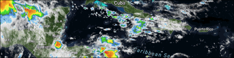
Present Condition: Partly cloudy, more so in the south. Mostly clear and windy in San Pedro, warm and humid. Relatively moist and unstable conditions prevail.

24hr Forecast: Sunny with a few cloudy spells this afternoon and cloudy at times tonight and tomorrow morning. Showers or thunderstorms will be isolated except for a few more inland this afternoon spreading to the south and coast tonight and tomorrow morning.

Outlook: A few showers and isolated thunderstorms will occur mainly inland Tuesday afternoon then some showers, a few thunderstorms and periods of rain will affect most areas Tuesday night and Wednesday morning.

[Linked Image]

[Linked Image]

Flood Report and Forecast for June 28, 2021

River Conditions

REGION 7-Levels are near normal on the RIO HONDO at Blue Creek, Santa Cruz, San Antonio, San Roman and Douglas to the coast. On the NEW RIVER, at Tower Hill levels are below normal and at Caledonia levels are near normal and steady.

REGION 9 - On the MACAL RIVER reservoir levels at all BECOL facilities are below the spillways; and at San Ignacio, levels remain below the low-level bridge and steady. Levels on the MOPAN RIVER at Benque Viejo Town are below normal and steady.

The BELIZE RIVER at the Double Run is below normal and steady. The CROOKED TREE LAGOON remains below the causeway and steady.

REGION 11 - Levels on the SIBUN RIVER at Freetown Sibun is below normal and steady. Levels on the SOUTHERN LAGOON near Gales Point Village is above normal and steady. The watersheds on the EASTERN SLOPES OF THE MAYAN MOUNTAINS are below normal and steady. The SITTEE RIVER at Kendal Bridge is near normal and steady. On the Swasey and Bladen branches of the MONKEY RIVER, levels are below normal and steady. Levels on the DEEP RIVER at Medina Bank, are below normal and steady. The RIO GRANDE at San Pedro Columbia and Big Falls am below normal and steady. The MOHO RIVER at Blue Creek South and at Jordan is near normal and increasing slowly. The TEMASH RIVER at Crique Sarco is below normal and steady.

REGION 13- On the SARSTOON RIVER levels am normal and steady.

FLOOD FORECAST

REGION 7 -On the RIO HONDO at Blue Creek, Santa Cruz, San Antonio, San Roman, and Douglas to the coast, levels are expected to increase minimally. On the NEW RIVER at Tower Hill and at Caledonia, a minimal rise in river levels is expected.

REGION 9 - On the MACAL RIVER, reservoir levels at all BECOL facilities is expected to approach the spillways; at San Ignacio, levels are expected to remain below the low-level bridge. On the MOPAN RIVER at Benque Viejo Town, a minimal rise in river levels is expected.

On the BELIZE RIVER at Double Run, near normal levels are expected and on the CROOKED TREE LAGOON, levels are expected to remain below the causeway.

REGION 11 - On the SIBUN RIVER at Freetown Sibun, a minimal increase in river levels is expected. On the SOUTHERN LAGOON near Gales Point Village above normal levels is expected. In the watersheds on the EASTERN SLOPES OF THE MAYAN MOUNTAINS levels are expected to increase to above normal levels. On the SITTEE RIVER at Kendal Bridge, levels are expected to increase to above normal levels. On the Swasey and Bladen branches of the MONKEY RIVER, below normal levels are expected increase to above normal levels. On the RIO GRANDE at San Pedro Columbia and Big Falls South, below normal levels are expected to increase to above normal levels. On the MOHO RIVER at Blue Creek South and Jordan, levels are expected to increase to above normal levels. On the TEMASH RIVER at Crique Sarco, levels are expected to increase to above normal levels.

REGION 13- On the SARSTOON RIVER, an increase in river levels is expected.

THE NEXT FLOOD REPORT AND FORECAST WILL BE ISSUED ON JUNE 30, 2021

Joined: Dec 2006
Posts: 13,675
Offline
Ambergris Caye we have a East wind at 16 mph creating moderate sea conditions around our barrier reef with a cloudy sky and a predicted high of 88f.

FB_IMG_1624905085390.jpg

White Sands Dive Shop
https://whitesandsdiveshop.com/
Joined: Oct 1999
Posts: 84,398
Marty Online Happy OP
OP Online Happy
Belize City looking sooo pretty! Photos by San Pedro Scoop

[Linked Image]

[Linked Image]


Link Copied to Clipboard
April
S M T W T F S
1 2 3 4 5 6
7 8 9 10 11 12 13
14 15 16 17 18 19 20
21 22 23 24 25 26 27
28 29 30
Cayo Espanto
Click for Cayo Espanto, and have your own private island
More Links
Click for exciting and adventurous tours of Belize with Katie Valk!
Who's Online Now
1 members (Marty), 148 guests, and 0 robots.
Key: Admin, Global Mod, Mod
Forum Statistics
Forums44
Topics79,204
Posts500,028
Members20,468
Most Online7,413
Nov 7th, 2021


AmbergrisCaye.com CayeCaulker.org HELP! Visitor Center Goods & Services San Pedro Town
BelizeSearch.com Message Board Lodging Diving Fishing Things to Do History
BelizeNews.com Maps Phonebook Belize Business Directory
BelizeCards.com Picture of the Day

The opinions and views expressed on this board are the subjective opinions of Ambergris Caye Message Board members
and not of the Ambergris Caye Message Board its affiliates, or its employees.

Powered by UBB.threads™ PHP Forum Software 7.7.5