|
|
Joined: Oct 1999
Posts: 84,398
|
OP

|
Belize Weather Forecast: July 7, 2021


 General Situation:
Ambergris Caye: Conditions this morning by Elbert just before or after this post!
Belize NMS:
Present Condition: Mostly cloudy this morning, less so in the north. Mostly cloudy and windy in San Pedro. Generally fair weather prevails.
Advisories: None.
24-hour forecast:
Sunny with cloudy spells today and partly cloudy skies tonight. Showers will be isolated.
Winds: E, 10-20 kts
Sea State:
Moderate
Waves: 4-6 ft
Sea Surface Temperature (°f): 86
Outlook:
For Thursday is for mostly for conditions with isolated showers; showers and thunderstorms will increase along the coast Thursday night.
Sargassum Forecast from June 29 to July 7:
The chances of sargassum affecting local beaches will remain high during the next few days. San Pedro has a high probability and a moderate impact.
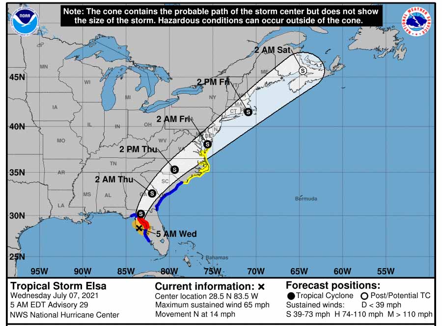
Tropical Weather Outlook:
At 6:00 am, Tropical Storm Elsa was centered near latitude 29.2N, longitude 83.6W, or about 115 miles northwest of Tampa, Florida. Elsa was moving to the north at 14mph with maximum sustained winds of 65mph.
Click for more...
Marine Conditions:

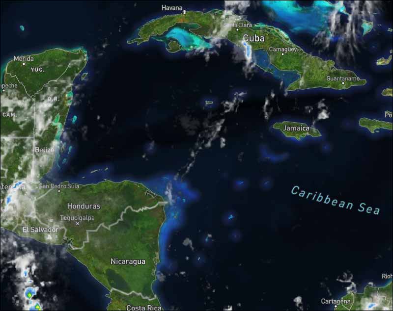
The Caribbean Sea
An overnight ASCAT pass depicted near-gale force E winds in the
south-central Caribbean within 120 nm of the coast of Colombia
between 72W and 75W. Strong east winds extend to 14N between 71W
and 77W. Mainly fresh east winds are over the remainder of the
central Caribbean, with seas of 6-9 ft. Elsewhere in the basin,
gentle to moderate trades prevail with wave heights in the range
of about 3-6 ft. Isolated showers are noted from 19N to 21N
between 61W-65W.
For the forecast: Widespread fresh to strong trades will begin to
increase in the south-central Caribbean beginning tonight and
continue through late Fri. These winds may reach near gale force
Thu through Fri night. Fresh to strong winds will pulse at night
in the Gulf of Honduras through the rest of the week.
| |
High |
Low |
| Coastal |
32° C
89° F
|
28° C
82° F
|
| Inland |
35° C
95° F
|
24° C
76° F
|
| Hills |
29° C
84° F
|
19° C
66° F
|
| TIDES: |
|
| High: 7:43 AM |
Low: 3:16 PM |
| High: 9:45 PM |
Low: 2:16 AM (Thu) |
| Sunrise: 5:23 AM |
Moonset: 4:47 PM |
| Sunset: 6:31 PM |
Moonrise: 4:04 AM (Thu) |

Four Day Weather Outlook:

For more information, check the Daily Tropical Weather Outlook.
Climate Prediction Center's Central America Hazards Outlook
Belize National Emergency Management Organization (NEMO)
Ambergris Caye:
https://www.wunderground.com/weather/bz/san-pedro
Philip S W Goldson International Airport:
https://www.wunderground.com/weather/bz/belize/MZBZ?cm_ven=localwx_today
Belmopan:
https://www.wunderground.com/weather/bz/belmopan/17.26%2C-88.78
Caye Caulker:
http://cayecaulkerweather.com/weatherdata/caye-caulker-belize-live-weather-data.htm
For the North Atlantic...Caribbean Sea and the Gulf of Mexico:
...ELSA MOVING NORTHWARD ALMOST PARALLEL TO THE WEST COAST OF FLORIDA...
At 5 a.m. EDT, the center of Tropical Storm Elsa was located west of the Florida coastline about 70 miles (115 km) west-northwest of Tampa and about 50 miles (75 km) south-southwest of Cedar Key. It's moving toward the north near 14 mph (22 km/h), and this general motion is expected to continue through tonight. A turn toward the north near 14 mph (22 km/h), and a general northward motion is expected to continue through this afternoon. A turn toward the north-northeast is expected late this afternoon or tonight, followed by a faster northeastward motion by late Thursday. On the forecast track, Elsa will move near or over portions of the west coast of Florida this morning, then make landfall along the north Florida Gulf coast by late this morning or this afternoon. The storm should then move across the southeastern and mid-Atlantic United States through Thursday.
Maximum sustained winds are now near 65 mph (100 km/h) with higher gusts. Tropical-storm-force winds extend outward up to 90 miles (150 km) from the center. Some fluctuations in the intensity are possible until landfall later today. Weakening will begin after Elsa moves inland.

For further information on tropical conditions, check the daily Tropical Weather Outlook, click here.
|
|
|
|
|
|
Joined: Oct 1999
Posts: 84,398
|
|
OP
|
We are monitoring multiple tropical waves tracking to the west across the Atlantic Ocean basin. Sahara Dust is plentiful across the tropical Atlantic Ocean; thus, cyclone development is NOT expected thru July 11, 2021. ![[Linked Image]](//Ambergriscaye.com/art8/213991567_4393843967335114_2979661965785096442_n.jpg) ![[Linked Image]](//Ambergriscaye.com/art8/211307025_3010404012574330_9100859295379704695_n.jpg) The dense cloud of dust is starting to penetrate the Caribbean later on it will spread to South America and Central America and part of Mexico. ![[Linked Image]](//Ambergriscaye.com/art8/saharadustjuly7.jpg) For further information on tropical conditions, check the daily Tropical Weather Outlook, click here For further information on tropical conditions, check the daily Tropical Weather Outlook, click here
|
|
|
|
|
Joined: Oct 1999
Posts: 84,398
|
|
OP
|
The easterly Caribbean winds have a little cloud in them, there are several different directions of high level, non moving about very much, they are causing a blanket of cloud over most of Belize, but not causing any rain. No rain on the radar at this time. Looks as if today will be a mixture of cloud and some sunshine, and probably little or no rain. ![[Linked Image]](//Ambergriscaye.com/art8/belmopanwx210707.jpg) Temperatures in Belmopan : ( Coast usually cooler, hills even cooler ) Last Night 25°C 78°F Yesterday max. 34°C 92°F Yesterday Rain 0.2 mm ( 0.0")
|
|
|
|
|
Joined: Oct 1999
Posts: 84,398
|
|
OP
|
Take a drive through Hopkins.
Flood Report and Forecast for July 7, 2021
River Conditions
REGION 7 - On the RIO HONDO at Blue Creek and Santa Cruz, San Antonio, San Roman and Douglas to the coast, levels are near normal and steady. On the NEW RIVER, at Tower Hill and Caledonia, levels are near normal and steady.
REGION 9 - On the MACAL RIVER reservoir levels at all BECOL facilities are below the spillways; and at San Ignacio, levels remain below the low-level bridge and steady. Levels on the MOPAN RIVER at Benque Viejo Town are below normal and steady.
The BELIZE RIVER at the Double Run is below normal and steady. The CROOKED TREE LAGOON remains below the causeway and falling.
REGION 11 - Levels on the SIBUN RIVER at Freetown Sibun is below normal and steady. Levels on the SOUTHERN LAGOON near Gales Point Village is near normal and steady. The watersheds on the EASTERN SLOPES OF THE MAYAN MOUNTAINS are below normal and steady. The SITTEE RIVER at Kendal Bridge is normal and steady. On the Swasey and Bladen branches of the MONKEY RIVER, levels are below normal and falling. Levels on the DEEP RIVER at Medina Bank are below normal and falling. The RIO GRANDE at San Pedro Columbia and Big Falls are below normal and steady. On the MOHO RIVER at Blue Creek South and Jordan, levels are normal and falling. The TEMASH RIVER at Crique Sarco is normal and steady.
REGION 13 - On the SARSTOON RIVER, levels are normal and steady.
FLOOD FORECAST
REGION 7 - On the RIO HONDO at Blue Creek, Santa Cruz, San Antonio, San Roman, and Douglas to the coast, normal and steady levels are expected. On the NEW RIVER at Tower Hill and at Caledonia, normal and steady levels are expected.
REGION 9 - On the MACAL RIVER, reservoir levels at Chalillo, Mollejon, and Vaca facilities, levels are expected to remain below the spillways; at San Ignacio, no significant change in river levels is expected. On the MOPAN RIVER at Benque Viejo Town, no significant change in river levels is expected.
On the BELIZE RIVER at Double Run, levels are expected to increase minimally; and on the CROOKED TREE LAGOON, no significant change is expected.
REGION 11 - On the SIBUN RIVER at Freetown Sibun, levels are expected to increase minimally. On the SOUTHERN LAGOON near Gales Point Village, no significant change is expected. In the watersheds on the EASTERN SLOPES OF THE MAYAN MOUNTAINS no significant change is expected. On the SITTEE RIVER at Kendal Bridge, no significant change is expected. On the Swasey and Bladen branches of the MONKEY RIVER, no significant change is expected. On the RIO GRANDE at San Pedro Columbia and Big Falls South, no significant change is expected. On the MOHO RIVER at Blue Creek South and Jordan, no significant change is expected. On the TEMASH RIVER at Crique Sarco, no significant change is expected.
REGIONS 13 - On the SARSTOON RIVER, no significant change is expected.
THE NEXT FLOOD REPORT AND FORECAST WILL BE ISSUED ON JULY 9, 2021
|
|
|
|
S |
M |
T |
W |
T |
F |
S |
|
|
1
|
2
|
3
|
4
|
5
|
6
|
|
7
|
8
|
9
|
10
|
11
|
12
|
13
|
|
14
|
15
|
16
|
17
|
18
|
19
|
20
|
|
21
|
22
|
23
|
24
|
25
|
26
|
27
|
|
28
|
29
|
30
|
|
|
|
|
|
|
0 members (),
260
guests, and
0
robots. |
|
Key:
Admin,
Global Mod,
Mod
|
|
|
Forums44
Topics79,204
Posts500,030
Members20,470
| |
Most Online7,413
Nov 7th, 2021
|
|
|
|

![[Linked Image]](http://Ambergriscaye.com/art8/213991567_4393843967335114_2979661965785096442_n.jpg)
![[Linked Image]](http://Ambergriscaye.com/art8/211307025_3010404012574330_9100859295379704695_n.jpg)
![[Linked Image]](http://Ambergriscaye.com/art8/saharadustjuly7.jpg)
![[Linked Image]](http://Ambergriscaye.com/art8/belmopanwx210707.jpg)


