Belize Weather Forecast: August 5, 2021


 General Situation:
Ambergris Caye: Conditions this morning by Elbert just before or after this post!
Belize NMS:
Present Condition: Cloudy in the south, much less so in the north. Mostly clear in San Pedro. Generally fair weather prevailing, then expect an increase in moisture on Friday.
Advisories: None.
24-hour forecast:
Today skies will be mostly sunny. Tonight skies will be partly cloudy to cloudy. Shower activity will be generally isolated today, then tonight and tomorrow morning expect a few outbreaks of showers and isolated thunderstorms to develop along coastal and southern areas.
Winds: E, 5-15 kts
Sea State:
Light Chop
Waves: 2-4 ft
Sea Surface Temperature (°f): 86
Outlook:
For Friday and Friday night is for cloudy spells with a few outbreaks of showers and isolated thunderstorms developing mainly over the south and along coastal areas.
Sargassum Forecast from August 3 to August 11:
Satellite and surface observations continue to show several sargassum mats just offshore and along beaches across the country. There continues to be a high chance of more sargassum beaching during the next few days. San Pedro has a moderate probability and a moderate impact.
Tropical Weather Outlook:
Tropical cyclone formation is not expected in the North Atlantic, the Caribbean Sea or the Gulf of Mexico within the next 48 hours.
Click for more...
Marine Conditions:

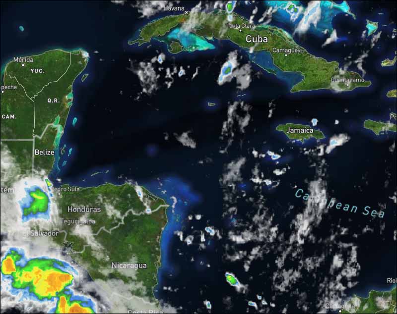
The Caribbean Sea
There are three tropical waves in the Atlantic, and one in the Caribbean.
Enhanced by divergent winds associated with an upper-level low
near Jamaica at 15N768, convergent trade winds are supporting
scattered showers across the western half of the basin.
The pressure gradient in the south-central Caribbean continues to
support moderate to fresh trades and seas of 4 to 6 ft in this
area. Elsewhere in the basin, gentle to moderate trades and seas
at 2 to 4 ft are evident.
For the forecast, fresh trade winds across the south-central
Caribbean will increase slightly, pulsing to strong through Fri
night near the coast of NE Colombia and NW Venezuela. Expect fresh
east winds in the Gulf of Honduras from late afternoon through
the nighttime hours, each day through Fri night. Fresh NE winds
are expected in the Windward Passage during the evening hours this
weekend. Gentle to moderate trades will prevail elsewhere.
| |
High |
Low |
| Coastal |
31° C
88° F
|
27° C
81° F
|
| Inland |
34° C
94° F
|
24° C
75° F
|
| Hills |
28° C
82° F
|
20° C
68° F
|
| TIDES: |
|
| High: 7:18 AM |
Low: 2:57 PM |
| High: 9:25 PM |
Low: 1:53 AM (Fri) |
| Sunrise: 5:33 AM |
Moonset: 4:25 PM |
| Sunset: 6:23 PM |
Moonrise: 3:40 AM (Fri) |

Four Day Weather Outlook:

For more information, check the Daily Tropical Weather Outlook.
Climate Prediction Center's Central America Hazards Outlook
Belize National Emergency Management Organization (NEMO)
Ambergris Caye:
https://www.wunderground.com/weather/bz/san-pedro
Philip S W Goldson International Airport:
https://www.wunderground.com/weather/bz/belize/MZBZ?cm_ven=localwx_today
Belmopan:
https://www.wunderground.com/weather/bz/belmopan/17.26%2C-88.78
Caye Caulker:
http://cayecaulkerweather.com/weatherdata/caye-caulker-belize-live-weather-data.htm
For the North Atlantic...Caribbean Sea and the Gulf of Mexico:
As of Thursday morning, EDT, there are currently no organized tropical systems found across the basin, and none are expected to develop through at least the next couple of days.
A tropical wave over the central Atlantic Ocean is showing some signs of development as a low pressure area is trying to form. Thunderstorm activity remains isolated with this, and no organized convection is with the low pressure area at this time. Wind shear is light across the central Atlantic, but dry air continues to envelop the system. As this pushes closer to the Leeward Islands over the next several days, this may become more organized and will need to be monitored for possible development.
Conditions may be a little more supportive for development over the next few days as a robust wave exits the African coast into tonight. The environment in the vicinity of the Cabo Verde Islands, particularly south of the islands, will be a little more favorable for development. Wind shear may yet be a factor, but it is possible that a tropical cyclone will take shape. However, that will depend on the magnitude of shear and where a surface low ultimately develops, assuming this takes place.
Elsewhere in the Atlantic, development prospects remain severely limited by very dry air and prohibitively strong wind shear.


For further information on tropical conditions, check the daily Tropical Weather Outlook, click here.
|


![[Linked Image]](http://Ambergriscaye.com/art8/232609520_4483851965000980_6360181876352501186_n.jpg)


![[Linked Image]](http://Ambergriscaye.com/art8/belmopanwx210805.jpg)
![[Linked Image]](http://Ambergriscaye.com/art8/dailywx210805b.jpg)
![[Linked Image]](http://Ambergriscaye.com/art8/dailywxB210805.jpg)
![[Linked Image]](http://Ambergriscaye.com/art8/234184816_3039401419674589_5499210524302309441_n.jpg)
![[Linked Image]](http://Ambergriscaye.com/art8/454545400fuiy6.jpg)
![[Linked Image]](http://Ambergriscaye.com/art8/233722887_225718666221093_6942868636812991964_n.jpg)
![[Linked Image]](http://Ambergriscaye.com/art8/232275339_1515959602079108_7320119772527488353_n.jpg)


