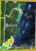
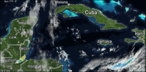
Present Condition: Mostly clear in the north, more clouds in the south. Clear blue sky in San Pedro. Mainly fair conditions will prevail over the next couple of days.
24hr Forecast: Mostly sunny during the daytime and partly cloudy tonight. Showers and thunderstorms will be isolated, with the chance for a few more inland this afternoon and over the south tonight.
Outlook: (Tuesday afternoon - midday Wednesday) Mainly fair with only isolated shower or isolated thunderstorms developing.
![[Linked Image]](//Ambergriscaye.com/art8/dailywx210830b.jpg)
![[Linked Image]](//Ambergriscaye.com/art8/dailywxB210830.jpg) Crown Weather:
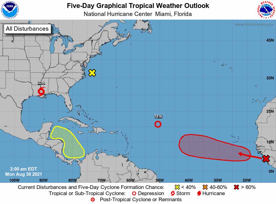
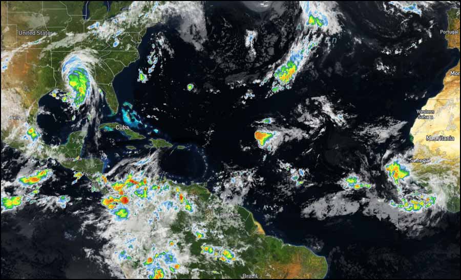
Crown Weather:![[Linked Image]](//Ambergriscaye.com/art8/two_atl_5d0dadasds88.jpg) Western Caribbean Tropical Development Possible Late This Week Or This Weekend:
Western Caribbean Tropical Development Possible Late This Week Or This Weekend: Unfortunately, the tropics are not taking any sort of a break after Ida as there are several areas that I'm keeping an eye on.
The first area to watch is an area of disturbed weather that's beginning to form over the far southwestern Caribbean. Model guidance seems to agree that an area of low pressure will form from this disturbed weather and gradually push northwestward near the coast of Central America by the middle and end of this week.
The big question is whether this disturbed weather will become entangled in Central America and never develop or will this disturbed weather get drawn northward into the Gulf of Mexico by late this week where it develops this weekend.
The key to this track looks to be the positioning and strength of a high pressure ridge over the southern Plains states this coming weekend and a trough of low pressure near the northeast US.
The ensemble model guidance mean of the 3 big models (GFS, Canadian and European) suggests that the high pressure ridge over the southern Plains states may back off and allow the trough of low pressure near the northeast US also moves westward and sets up near the Ohio Valley. Should this occur, it could lead to an opening for this disturbance to be drawn into the Gulf of Mexico rather than dissipating over Central America.
While a majority of the ensemble members seem to suggest that a track into Central America and eventually southern Mexico may occur, there are a few members that forecast a north and northwest track that would lead to something to really watch in the Gulf of Mexico for the weekend.
It's nothing to be overly concerned about at this point, but it is a disturbance that does need to be watched for now. Fortunately though, the latest guidance seems to be favoring the Central America dissipation scenario much more now.
Flood Report and Forecast for August 30, 2021River Conditions REGION 7 - Levels recorded today on the RIO HONDO at Blue Creek North, Santa Cruz, San Antonio, San Roman and Douglas to the Coast are above normal and receding. On the NEW RIVER, levels at Tower Hill and Caledonia are near normal and decreasing slowly.
REGION 9 - On the MACAL RIVER, reservoir levels at all BECOL facilities remains below the spillways; and at San Ignacio, levels are below the low-level bridge and steady. Levels on the MOPAN RIVER at Benque Viejo Town are above the normal and receding.
The BELIZE RIVER at DOUBLE Run is below normal and continues to recede. On the CROOKED TREE LAGOON, lagoon levels remains below the causeway.
REGION 11 - The SIBUN RIVER at Freetown Sibun continues to recede. Levels on the SOUTHERN LAGOON near Gales Point Village is near normal and steady. Flood stage have receded to above normal levels on the watersheds on the EASTERN SLOPES OF THE MAYAN MOUNTAINS, the SITTEE RIVER at Kendal Bridge, the MONKEY RIVER on the Swasey and Bladen, the DEEP RIVER at Medina Bank, the RIO GRANDE at San Pedro Columbia and Big Falls South, the MOHO RIVER at Blue Creek South and Jordan, and the TEMASH RIVER at Crique Sarco.
REGION 13 - On the SARSTOON RIVER, Flood stage continues to recede.
FLOOD FORECAST REGION 7 - On the RIO HONDO at Blue Creek North, Santa Cruz, San Antonio, San Roman, and Douglas to the Coast, receding levels is expected to increase minimally. On the NEW RIVER, at Tower Hill and Caledonia, normal levels are expected.
REGION 9 - On the MACAL RIVER, at all BECOL facilities, reservoir levels is expected to remain below the spillway; and at San Ignacio, levels is expected to remain below the Low-level bridge. On the MOPAN RIVER at Benque Viejo Town, above normal levels is expected to continue to recede.
On the BELIZE RIVER at Double Run, below normal levels is expected; and on the CROOKED TREE LAGOON, lagoon levels is expected to remain the causeway.
REGION 11- On the SIBUN RIVER at Freetown Sibun, receding levels is expected to continue. On the SOUTHERN LAGOON near Gales Point Village, no significant change is expected. In the watersheds on the EASTERN SLOPES OF THE MAYAN MOUNTAINS and the SITTEE RIVER at Kendal Bridge, above normal and slowly receding levels is expected. On the Swasey and Bladen Branches of the MONKEY RIVER above normal levels is expected. On the DEEP RIVER at Medina Bank, below normal levels is expected. The RIO GRANDE at San Pedro Columbia and Big Falls South, is expected to continue to recede becoming above normal levels. On the MOHO RIVER at Blue Creek South and Jordan, above normal levels is expected. On the TEMASH RIVER at Crique Sarco, above normal levels is expected.
REGIONS 13 - On the SARSTOON RIVER, above normal levels is expected.
THE NEXT FLOOD REPORT AND FORECAST WILL BE ISSUED ON SEPTEMBER 1, 2021


 General Situation:


![[Linked Image]](http://Ambergriscaye.com/art8/belmopanwx210830.jpg)
![[Linked Image]](http://Ambergriscaye.com/art8/dailywx210830b.jpg)
![[Linked Image]](http://Ambergriscaye.com/art8/dailywxB210830.jpg)
![[Linked Image]](http://Ambergriscaye.com/art8/two_atl_5d0dadasds88.jpg)
![[Linked Image]](http://Ambergriscaye.com/art8/240987076_6025628954145255_623823457533968156_n.jpg)


