|
|
Joined: Oct 1999
Posts: 84,398
|
OP

|
Belize Weather Forecast: October 19, 2021


 General Situation:
Ambergris Caye: Conditions this morning by Elbert just before or after this post!
Belize NMS:
Present Condition: Mostly cloudy skies this morning throughout the country as a tropical wave moves through. Mostly cloudy in San Pedro. Moist and unstable conditions linger over the area.
Advisories: None.
24-hour forecast:
Cloudy spells with a few showers and isolated thunderstorms over most areas today then increasing and affecting mainly southern and coastal areas tonight.
Winds: E-NE, 5-15 kts
Sea State:
Slight
Waves: 1-3 ft
Sea Surface Temperature (°f): 87
Outlook:
For Wednesday and Wednesday night is for a similar trend to occur.
Sargassum Forecast from October 12 to October 20:
There is a low to medium chance of new Sargassum mats drifting onshore during the next few days. San Pedro has a medium probability and a moderate impact.
Tropical Weather Outlook:
Tropical Cyclone formation is not expected in the North Atlantic, Caribbean Sea and Gulf of Mexico, during the next 48 hours.
Click for more of the tropical weather outlook...
Marine Conditions:

The Caribbean Sea
A weak pressure pattern prevails across the Caribbean waters.
Gentle to moderate winds are noted over the central and eastern
Caribbean south of 13N as well as in the lee of Cuba. Light to
gentle winds prevail elsewhere. Seas are in the 1-3 ft range
across the Caribbean waters, reaching near 4 ft in the Yucatan
channel.
For the forecast, high pressure building N of the area will bring
a return to moderate trade winds to the Caribbean today. Winds
will further increase to moderate to fresh winds Wed through Sat.
| |
High |
Low |
| Coastal |
30° C
86° F
|
26° C
78° F
|
| Inland |
31° C
88° F
|
22° C
72° F
|
| Hills |
24° C
76° F
|
19° C
66° F
|
| TIDES: |
|
| High: 9:33 AM |
Low: 3:20 PM |
| High: 9:21 PM |
Low: 3:50 AM (Wed) |
| Sunrise: 5:47 AM |
Moonset: 4:55 AM |
| Sunset: 5:27 PM |
Moonrise: 5:09 PM |

Four Day Weather Outlook:

For more information, check the Daily Tropical Weather Outlook.
Climate Prediction Center's Central America Hazards Outlook
Belize National Emergency Management Organization (NEMO)
Ambergris Caye:
https://www.wunderground.com/weather/bz/san-pedro
Philip S W Goldson International Airport:
https://www.wunderground.com/weather/bz/belize/MZBZ?cm_ven=localwx_today
Belmopan:
https://www.wunderground.com/weather/bz/belmopan/17.26%2C-88.78
Caye Caulker:
https://www.wunderground.com/weather/bz/caye-caulker-village


|
|
|
|
|
|
Joined: Oct 1999
Posts: 84,398
|
|
OP
|
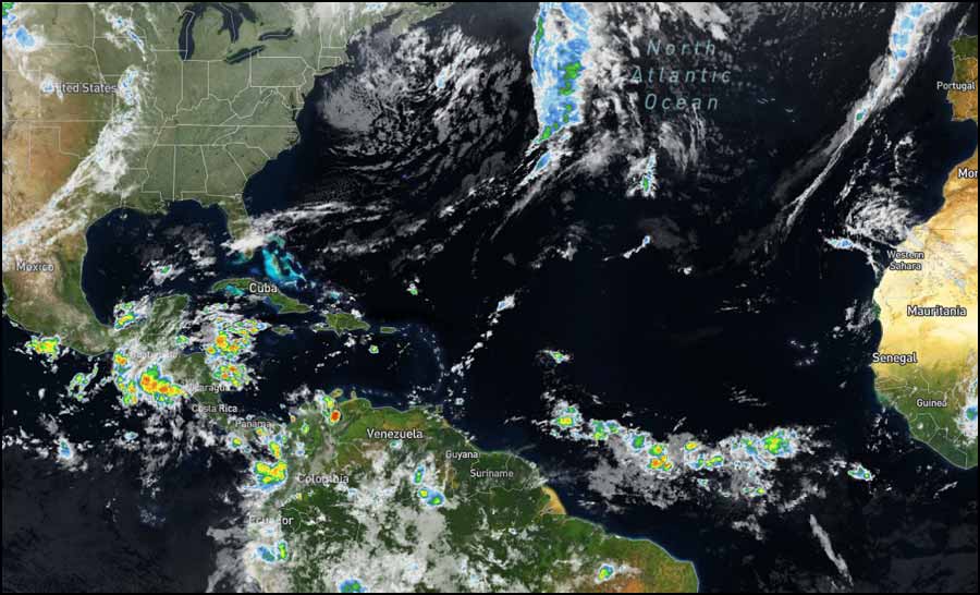
The Atlantic basin remains dormant with currently no organized tropical systems and no tropical development expected through at least the end of the week. The tropical season still has several weeks left as it runs through the end of November, so more tropical activity is possible farther down the road. But for the time being, all is quiet in the Atlantic. Over the eastern Pacific basin, a broad area of low pressure is expected to form in a few days a couple of hundred miles south of the coast of southern Mexico. Some gradual development of this system is possible thereafter as it moves west-northwestward off the coast of Mexico. It has a near zero chance of formation during the next 48 hours and a low (30 percent) chance during the next five days. ![[Linked Image]](//Ambergriscaye.com/art8/246469424_4670694606329316_5990761939660706783_n.jpg) We are monitoring an undesignated tropical wave tracking to the west at 10 mph in the general direction of Trinidad and Tobago and northern South America. Although the path of this tropical wave is through light wind shear, model guidance runs the past 35 hours has considerably decreased the chance of cyclone development (tropical depression or tropical storm). ![[Linked Image]](//Ambergriscaye.com/art8/245928867_4719399238112917_9182498003471427764_n.jpg) Tropical wave no. 39 is interacting with the stationary front over the Gulf of Mexico. Note tropical wave 40 over Central America and the Caribbean. It's approaching the peninsula. Tropical waves will continue to arrive in what remains of the week. Image from late Monday night. ![[Linked Image]](//Ambergriscaye.com/art8/245975546_3102840703330660_6619821354850382658_n.jpg) For more information, check the daily Tropical Weather Outlook, click here For more information, check the daily Tropical Weather Outlook, click here
|
|
|
|
|
Joined: Dec 2006
Posts: 13,675
|
|
|
On Ambergris Caye this morning the breeze is from the NE at 2 mph. We have been enjoying a week of calm sea around our barrier reef with a few light rain showers in the evenings. Today will be cooler with a predicted high temperature of only 86 f.
10 am-- I'm wrong a lot. It's raining buckets. But the morning was nice.
Last edited by elbert; 10/19/21 11:35 AM.
|
|
|
|
|
Joined: Oct 1999
Posts: 84,398
|
|
OP
|
Those areas that missed the heavy night rain, look as if they will be getting it this morning, already starting in Stann Creak coastal areas and north Toledo. Getting to the central and northern areas later this morning. The rain forming cloud being the high level cloud from the SSW but being brought in by they easterly Caribbean. Looks like rain this morning most, showers, some heavy rain, later mainly clouds, the odd sunshine occasionally. ![[Linked Image]](//Ambergriscaye.com/art8/belmopanwx211019.jpg) Temperatures in Belmopan : ( Coast usually cooler, hills even cooler ) Last Night 25°C 76°F Yesterday max. 31°C 89°F Yesterday Rain 4.5 mm (0.1") Over Night Rain 0.5 mm (0.0")
|
|
|
|
|
Joined: Oct 1999
Posts: 84,398
|
|
OP
|
Rain mainly in the north, but some in central parts. ![[Linked Image]](//Ambergriscaye.com/art8/belmopanwx211019b.jpg) Crown Weather:No Tropical Development Is Expected Across The Atlantic, Caribbean Or Gulf Of Mexico The Rest Of This Week Into This Weekend; Is The Atlantic Hurricane Season Now Done? Crown Weather:No Tropical Development Is Expected Across The Atlantic, Caribbean Or Gulf Of Mexico The Rest Of This Week Into This Weekend; Is The Atlantic Hurricane Season Now Done?Things remain quiet across the Atlantic, Caribbean and Gulf of Mexico with no tropical development expected for the rest of this week and very probably this weekend. I am at a loss and have been scratching my head trying to figure out why tropical development has not occurred, even though everything in the pattern, including a La Nina and an upward motion pulse of the MJO, should be favorable for a spurt of tropical development this month. Usually, during a La Nina year with a favorable MJO pulse would produce late season tropical systems and yet nothing is on the horizon - obviously, a great thing, but still perplexing. This lack of tropical activity is not only just happening in the Atlantic, but it's also occurring in the eastern, central and western Pacific. For the Atlantic, it seems the reason for a lack of activity is a persistent trough of low pressure over the eastern US which seems to be imparting unfavorable conditions over the Caribbean. Fortunately, it just seems like things aren't clicking in place for development and my forecast for a busy October has obviously gone down in flames and this is something that I'm going to try to figure out what I missed and how I can do better next time. So, now the question becomes are we done with the 2021 Atlantic Hurricane Season? To be perfectly honest, I don't know. On one hand, we should still probably see at least one or two more named storms given we are in a La Nina. On the other hand, a look at the conditions across the Atlantic Basin says it all - nothing is going to form anytime soon. It should be noted that the model guidance are hinting that tropical activity may pick up right at the end of this month and the beginning of November. All 3 ensemble models (GFS ensemble, Canadian ensemble and European ensemble) point to the central and western Caribbean as a place to watch for tropical development at the very end of this month and the very beginning of November. Is this possible? Given we are in La Nina conditions - absolutely. Do I believe it yet? Nope, especially, given that the models seem to keep pushing back this forecast increase in activity. With that said, I'll be monitoring the guidance and other data closely to see if we start to get some consistency in the possibility of development near the end of the month. So, for now, things will be quiet and fortunately, I don't see any evidence that we'll see tropical development for at least the next 5 to 7 days and possibly longer than this.
|
|
|
|
|
Joined: Oct 1999
Posts: 84,398
|
|
OP
|
Present Condition: Heavy cloud cover throughout the country, rain and wind in San Pedro. Moist and unstable conditions will continue as a tropical wave approach and cross the country. Flood watch: A flood watch is in effect for low lying and flood prone areas.24hr Forecast: Mostly cloudy skies today with a few showers, isolated thunderstorms and periods of rain affecting mainly central coastal and northern areas at first, then spreading to inland areas. Tonight and tomorrow morning skies will be cloudy to overcast, with some outbreask of showers, thunderstorms and periods of rain mainly along the coast and southern areas, then spreading over most areas. Outlook: For Wednesday afternoon thru to Thursday afternoon is for cloudy spells with a few outbreaks of showers and thundertsorms, along with periods rain developing mainly along central coastal and northern areas at first then spreading to most areas. ![[Linked Image]](//Ambergriscaye.com/art8/dailywx211019b.jpg) ![[Linked Image]](//Ambergriscaye.com/art8/dailywx211019c.jpg) ![[Linked Image]](//Ambergriscaye.com/art8/dailywxB211019.jpg) Tropical wave #40 and a trough will be leaving scattered storms in much of the peninsula. ![[Linked Image]](//Ambergriscaye.com/art8/247414029_3103396273275103_5350126906683524370_n.jpg)
|
|
|
|
|
Joined: Oct 1999
Posts: 84,398
|
|
OP
|
Flood Report and Forecast for October 19, 2021
River Conditions
REGION 7 - On the RIO HONDO at Blue Creek North and downstream at Santa Cruz, San Antonio, San Roman, and Douglas to the Coast, levels are below normal and falling. On the NEW RIVER at Tower Hill levels are below normal and steady; and at Caledonia, levels are below normal and falling.
REGION 9 - On the MACAL RIVER, reservoir levels at all BECOL facilities remains below the spillways; and at San Ignacio, levels remain below the low-level bridge and steady. On the MOPAN RIVER at Benque Viejo Town, levels are below normal and falling.
On the BELIZE RIVER at Double Run, levels are below normal and steady; and on the CROOKED TREE LAGOON, lagoon levels remain below the causeway and steady.
REGION 11 - On the SIBUN RIVER at Freetown Sibun, below normal and steady levels continue. Levels on the SOUTHERN LAGOON at Gales Point Village is above normal and steady. In watersheds on the EASTERN SLOPES OF THE MAYAN MOUNTAINS levels are near normal and falling; and on the SITTEE RIVER at Kendal Bridge, levels are above normal and falling.
On the Swasey and Bladen branches of the MONKEY RIVER, levels are above normal and falling. On the DEEP RIVER at Medina Bank, levels are near normal and steady. On the RIO GRANDE at San Pedro Columbia and Big Falls South, levels are below normal and steady. On the MOHO RIVER at Blue Creek South levels are above normal and steady; and at Jordan, levels are below normal and falling. On the TEMASH RIVER at Crique Sarco, levels are below normal and shows a minimal rise.
REGION 13 - On the SARSTOON RIVER, levels are near normal and steady.
FLOOD FORECAST
Flood Threat - Residents in the Moho River Watershed in the Toledo District, are advised to be on the alert for an increase in river levels as the low-level bridge may become inundated
REGION 7 - On the RIO HONDO at Blue Creek North, and downstream at Santa Cruz, San Antonio, San Roman, and Douglas to the Coast, and on the NEW RIVER at Tower Hill and Caledonia, no significant change is expected.
REGION 9 - On the MACAL RIVER, at all BECOL facilities, reservoir levels are expected to remain below the spillway; and at San Ignacio, levels are expected to remain below the Low-level bridge. On the MOPAN RIVER at Benque Viejo Town, above normal levels is expected.
On the BELIZE RIVER at Double Run, below normal and steady levels is expected to continue; and on the CROOKED TREE LAGOON, lagoon levels are expected to remain below the causeway.
REGION 11 - On the SIBUN RIVER at Freetown Sibun, a minimal rise in river levels is expected. On the SOUTHERN LAGOON near Gales Point Village, no significant change is expected. In watersheds on the EASTERN SLOPES OF THE MAYAN MOUNTAINS, and on the SITTEE RIVER at Kendal Bridge, above normal levels are expected.
On the Swasey and Bladen branches of the MONKEY RIVER, expect a minimal rise in river levels. On the DEEP RIVER at Medina Bank, no significant change is expected. On the RIO GRANDE at San Pedro Columbia and Big Falls South, normal levels are expected. On the MOHO RIVER at Blue Creek South, a Flood Watch is in effect; and Jordan, an above normal levels is expected. On the TEMASH RIVER at Crique Sarco, an increased in river levels is expected.
REGIONS 13 - On the SARSTOON RIVER, normal and steady levels is expected.
THE NEXT FLOOD REPORT AND FORECAST WILL BE ISSUED ON OCTOBER 20, 2021, OR AS NECESSARY
|
|
|
|
|
Joined: Oct 1999
Posts: 84,398
|
|
OP
|
And so it continues, mostly in the north right now, then more coming in first for the south.
|
|
|
|
|
Joined: Oct 1999
Posts: 84,398
|
|
OP
|
|
|
|
|
S |
M |
T |
W |
T |
F |
S |
|
|
1
|
2
|
3
|
4
|
5
|
6
|
|
7
|
8
|
9
|
10
|
11
|
12
|
13
|
|
14
|
15
|
16
|
17
|
18
|
19
|
20
|
|
21
|
22
|
23
|
24
|
25
|
26
|
27
|
|
28
|
29
|
30
|
|
|
|
|
|
|
0 members (),
241
guests, and
0
robots. |
|
Key:
Admin,
Global Mod,
Mod
|
|
|
Forums44
Topics79,204
Posts500,030
Members20,470
| |
Most Online7,413
Nov 7th, 2021
|
|
|
|

![[Linked Image]](http://Ambergriscaye.com/art8/246469424_4670694606329316_5990761939660706783_n.jpg)
![[Linked Image]](http://Ambergriscaye.com/art8/245928867_4719399238112917_9182498003471427764_n.jpg)
![[Linked Image]](http://Ambergriscaye.com/art8/245975546_3102840703330660_6619821354850382658_n.jpg)


![[Linked Image]](http://Ambergriscaye.com/art8/belmopanwx211019.jpg)
![[Linked Image]](http://Ambergriscaye.com/art8/belmopanwx211019b.jpg)
![[Linked Image]](http://Ambergriscaye.com/art8/dailywx211019b.jpg)
![[Linked Image]](http://Ambergriscaye.com/art8/dailywx211019c.jpg)
![[Linked Image]](http://Ambergriscaye.com/art8/dailywxB211019.jpg)
![[Linked Image]](http://Ambergriscaye.com/art8/247414029_3103396273275103_5350126906683524370_n.jpg)


![[Linked Image]](http://Ambergriscaye.com/art8/247255436_280684660724493_7773787260382849978_n.jpg)
![[Linked Image]](http://Ambergriscaye.com/art8/246201049_280684734057819_5284845947162400495_n.jpg)
![[Linked Image]](http://Ambergriscaye.com/art8/246218222_280684677391158_8351688515514719035_n.jpg)


