Belize Weather Forecast: August 24, 2021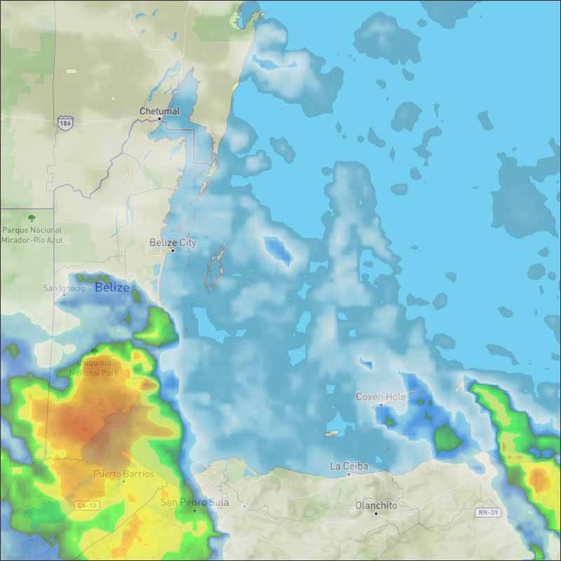
The Caribbean Sea There are three tropical waves in the Atlantic, and two in the Caribbean. The most recent scatterometer data provided observations of fresh to strong winds across most of the east and central Caribbean with fresh to locally strong NE winds across the Mona and Windward passages, and in the Gulf of Honduras. Seas are 8 to 10 ft near the coast of Colombia. Convection across the basin is related to the tropical waves. For the forecast, fresh to strong trade winds will dominate most of east and central Caribbean through midweek, with seas in the 8 to 10 ft range. Fresh to locally strong winds are also expected in the Windward passage through tonight. A tropical wave over the eastern Caribbean Sea is expected to form a broad area of low pressure over the southwestern Caribbean later this week.

Four Day Weather Outlook: 
For more information, check the Daily Tropical Weather Outlook. Climate Prediction Center's Central America Hazards Outlook Belize National Emergency Management Organization (NEMO)
Ambergris Caye:
For the North Atlantic...Caribbean Sea and the Gulf of Mexico: A tropical wave over the eastern Caribbean Sea is expected to form a broad area of low pressure over the southwestern Caribbean Sea later this week. Thereafter, environmental conditions are forecast to be favorable for gradual development, and a tropical depression could form by the end of the week while the system moves west-northwestward to northwestward over the northwestern Caribbean Sea.
* Formation chance through 48 hours...low...near 0 percent. For further information on tropical conditions, check the daily Tropical Weather Outlook, click here.
|
Belize Weather Forecast: August 24, 2021 - 08/24/21 12:03 PM

 General Situation:


Re: Belize Weather Forecast: August 24, 2021 - 08/24/21 12:04 PM
Continuing to increase the odds of cyclone development. Today will tropical wave 28 is in our area. Pay attention to the wave in the Eastern Caribbean and the future formation of a Central American Giro.
![[Linked Image]](//Ambergriscaye.com/art8/239262923_3054565804824817_4570197176634680696_n.jpg)
![[Linked Image]](//Ambergriscaye.com/art8/240609785_4542067979179378_2300154861868352569_n.jpg)
![[Linked Image]](http://Ambergriscaye.com/art8/239262923_3054565804824817_4570197176634680696_n.jpg)
![[Linked Image]](http://Ambergriscaye.com/art8/240609785_4542067979179378_2300154861868352569_n.jpg)
Re: Belize Weather Forecast: August 24, 2021 - 08/24/21 01:06 PM
On Ambergris Caye this morning we have a wind from the East at 15 mph creating rough sea conditions around our barrier reef. Today's expected high temperature is set at 86 f.

Re: Belize Weather Forecast: August 24, 2021 - 08/24/21 02:06 PM
Today is a bit similar to yesterday, the Caribbean winds coming in from the east, with some significant cloud patches, presently central Belize and extreme north, but there is high level coming down from the north and there has been a large area of ITCZ swell up over most of southern Belize this morning, with a lot of heavy rain. But it has brought the temperatures down.
Today
Patches of rain are still in the south and more isolated areas will affect much of Belize from time to time, presently south and central, later some north areas.
Tonight
Probably continuing with some rain over night.
![[Linked Image]](//Ambergriscaye.com/art8/belmopanwx210824.jpg)
Temperatures in Belmopan : ( Coast usually cooler, hills even cooler )
Last Night 24°C 75°F Yesterday max. 29°C 84°F Yesterday Rain 48.5 mm (1.9") Over Night Rain 28 mm (1.1")
Today
Patches of rain are still in the south and more isolated areas will affect much of Belize from time to time, presently south and central, later some north areas.
Tonight
Probably continuing with some rain over night.
![[Linked Image]](http://Ambergriscaye.com/art8/belmopanwx210824.jpg)
Temperatures in Belmopan : ( Coast usually cooler, hills even cooler )
Last Night 24°C 75°F Yesterday max. 29°C 84°F Yesterday Rain 48.5 mm (1.9") Over Night Rain 28 mm (1.1")
Re: Belize Weather Forecast: August 24, 2021 - 08/24/21 02:21 PM
Caribbean weather changes quickly. We have a good hard rain now.

Re: Belize Weather Forecast: August 24, 2021 - 08/24/21 06:04 PM
Present Condition: Partly cloudy on the mainland, mostly clear in the islands and San Pedro. Relatively moist and unstable conditions persist over some areas. There is a flood warning in effect for areas in the northern and southern districts.
24hr Forecast: Cloudy spells with a few showers and isolated thunderstorms around the country this afternoon then mostly over southern districts tonight, decreasing tomorrow morning.
Outlook: For Wednesday afternoon to Thursday midday is for generally fair weather except for isolated showers or isolated thunderstorms developing.
![[Linked Image]](//Ambergriscaye.com/art8/dailywx210824b.jpg)
![[Linked Image]](//Ambergriscaye.com/art8/dailywxB210824.jpg)
Crown Weather:
Increasing Likelihood Of Tropical Development From The Northwestern Caribbean Into The Southern Gulf Of Mexico Late This Week Into This Weekend
An active tropical wave located over the eastern Caribbean today is expected to reach the western Caribbean by late this week where it'll find a favorable environment for development. This means that I think that a tropical depression or a tropical storm will very likely develop in the northwestern Caribbean on Friday or in the southwestern Gulf of Mexico on Sunday.
Beyond this, the track of this system is going to hinge on the strength and orientation of a high pressure ridge over the southeastern United States. The trend over the last 24 hours is for weaker ridging near Texas and a ridge that sits near the Carolinas. This means that potentially this tropical system could be steered further north than what was thought yesterday. So, a hurricane threat to the Texas coast and possibly parts of the Louisiana coast is possible around Monday or Tuesday of next week.
While the model guidance are in very good agreement in forecasting tropical development in the northwestern Caribbean around Friday. The model guidance, however, still disagrees as to its exact track once it moves into the Gulf of Mexico.
I think that there is a 90-plus percent chance that we will have tropical development in the northwestern Caribbean by late Friday or early Saturday. This means that the eastern Yucatan Peninsula will probably be affected by tropical storm conditions throughout Friday into Friday night.
I also think that there is a 90-plus percent chance that we will have a strengthening tropical storm and then a strengthening hurricane that heads west-northwestward across the southern Gulf of Mexico and then the western Gulf of Mexico from Saturday afternoon to Monday morning.
Where this system makes landfall early next week is going to hinge on the strength and position of an upper level high pressure ridge that will be located over the southeastern United States. The western extent of this ridge is going to be very important in determining whether this system will head directly west-northwestward into eastern Mexico or be turned to the northwest and thus become a threat to some part of the Texas coast or even some part of the Louisiana coast early next week.
Another factor that's going to be very important is the exact location of where this potential system forms. If it forms in the area from the southwestern Caribbean to near the northern coast of Honduras and coast of Belize, I think it's likely it'd be guided towards a landfall in eastern or northeastern Mexico. On the other hand, if this system forms near the northeastern tip of the Yucatan Peninsula, it could be guided further north in the Gulf of Mexico leading to a potential impact to some part of the Texas coast or the Louisiana coast.
My thinking, at this point, is that the most likely track is for this system to develop into a tropical storm near the eastern Yucatan Peninsula on Friday and then move across the northern Yucatan Peninsula. From there, I think it's most plausible that this system will make landfall somewhere between northeastern Mexico and the middle Texas coast on Monday of next week as a hurricane.
![[Linked Image]](//Ambergriscaye.com/art8/two_atl_5d0dassadsa99.jpg)
![[Linked Image]](//Ambergriscaye.com/art8/239653117_3055402521407812_4153968452028831177_n.jpg)
For more information, check the daily Tropical Weather Outlook, click here
24hr Forecast: Cloudy spells with a few showers and isolated thunderstorms around the country this afternoon then mostly over southern districts tonight, decreasing tomorrow morning.
Outlook: For Wednesday afternoon to Thursday midday is for generally fair weather except for isolated showers or isolated thunderstorms developing.
![[Linked Image]](http://Ambergriscaye.com/art8/dailywx210824b.jpg)
![[Linked Image]](http://Ambergriscaye.com/art8/dailywxB210824.jpg)
Crown Weather:
Increasing Likelihood Of Tropical Development From The Northwestern Caribbean Into The Southern Gulf Of Mexico Late This Week Into This Weekend
An active tropical wave located over the eastern Caribbean today is expected to reach the western Caribbean by late this week where it'll find a favorable environment for development. This means that I think that a tropical depression or a tropical storm will very likely develop in the northwestern Caribbean on Friday or in the southwestern Gulf of Mexico on Sunday.
Beyond this, the track of this system is going to hinge on the strength and orientation of a high pressure ridge over the southeastern United States. The trend over the last 24 hours is for weaker ridging near Texas and a ridge that sits near the Carolinas. This means that potentially this tropical system could be steered further north than what was thought yesterday. So, a hurricane threat to the Texas coast and possibly parts of the Louisiana coast is possible around Monday or Tuesday of next week.
While the model guidance are in very good agreement in forecasting tropical development in the northwestern Caribbean around Friday. The model guidance, however, still disagrees as to its exact track once it moves into the Gulf of Mexico.
I think that there is a 90-plus percent chance that we will have tropical development in the northwestern Caribbean by late Friday or early Saturday. This means that the eastern Yucatan Peninsula will probably be affected by tropical storm conditions throughout Friday into Friday night.
I also think that there is a 90-plus percent chance that we will have a strengthening tropical storm and then a strengthening hurricane that heads west-northwestward across the southern Gulf of Mexico and then the western Gulf of Mexico from Saturday afternoon to Monday morning.
Where this system makes landfall early next week is going to hinge on the strength and position of an upper level high pressure ridge that will be located over the southeastern United States. The western extent of this ridge is going to be very important in determining whether this system will head directly west-northwestward into eastern Mexico or be turned to the northwest and thus become a threat to some part of the Texas coast or even some part of the Louisiana coast early next week.
Another factor that's going to be very important is the exact location of where this potential system forms. If it forms in the area from the southwestern Caribbean to near the northern coast of Honduras and coast of Belize, I think it's likely it'd be guided towards a landfall in eastern or northeastern Mexico. On the other hand, if this system forms near the northeastern tip of the Yucatan Peninsula, it could be guided further north in the Gulf of Mexico leading to a potential impact to some part of the Texas coast or the Louisiana coast.
My thinking, at this point, is that the most likely track is for this system to develop into a tropical storm near the eastern Yucatan Peninsula on Friday and then move across the northern Yucatan Peninsula. From there, I think it's most plausible that this system will make landfall somewhere between northeastern Mexico and the middle Texas coast on Monday of next week as a hurricane.
![[Linked Image]](http://Ambergriscaye.com/art8/two_atl_5d0dassadsa99.jpg)
![[Linked Image]](http://Ambergriscaye.com/art8/239653117_3055402521407812_4153968452028831177_n.jpg)
For more information, check the daily Tropical Weather Outlook, click here
Re: Belize Weather Forecast: August 24, 2021 - 08/24/21 10:30 PM
Flood Report and Forecast for August 24, 2021
FLOOD WARNING
RESIDENTS ARE ADVISED TO MONITOR THE RIVER LEVELS IN THEIR AREA CLOSELY, in these areas: IN THE NORTH - IN THE LOWER REACHES OF THE RIO HONDO; Santa Cruz, San Antonio, San Roman and Douglas to the Coast AND IN THE SOUTH - The Sittee River, The Monkey River -Swasey & Bladen Branches, The Deep River, The RIO GRANDE -San Pedro Columbia & Big Falls South, The MOHO RIVER - Blue Creek South & Jordan, and TEMASH RIVER.
River Conditions
REGION 7 - Levels recorded today on the RIO HONDO at Blue Creek is above normal and decreasing; at the lower reaches at Santa Cruz, San Antonio, San Roman and Douglas to the Coast are AT BANKFULL STAGE AND STEADY. On the NEW RIVER, levels at Towerhill and Caledonia are normal and increasing slowly.
REGION 9 - On the MACAL RIVER, reservoir levels at all BECOL facilities remains below the spillways; and at San Ignacio, levels are below the low-level bridge and increasing. Levels on the MOPAN RIVER at Benque Viejo Town is below normal and steady.
On the BELIZE RIVER at DOUBLE Run, below normal and steady levels were recorded at Double Run. The CROOKED TREE LAGOON remains below the causeway and steady.
REGION 11 - Levels recorded on the SIBUN RIVER at Freetown Sibun indicates a minimal rise but remains at near normal. Levels on the SOUTHERN LAGOON near Gales Point Village is near normal and steady. River levels in watersheds on the EASTERN SLOPES OF THE MAYAN MOUNTAINS are at FLOOD STAGE. The SITTEE RIVER at Kendal Bridge is at FLOOD STAGE. FLOOD LEVELS EXITS on the Swasey and Bladen branches of the MONKEY RIVER. Levels on the DEEP RIVER at Medina Bank is AT FLOOD STAGE. On the RIO GRANDE at San Pedro Columbia, level is ABOVE THE BRIDGE. At Big Falls South, levels are at FLOOD STAGE and Increasing. RISING FLOOD LEVELS exits on the MOHO RIVER at Blue Creek South and Jordan. The TEMASH RIVER at Crique Sarco is at FLOODED and increasing.
REGION 13 - On the SARSTOON RIVER, levels are at FLOOD STAGE.
FLOOD FORECAST
REGION 7 - On the RIO HONDO at Blue Creek, levels is expected to continue to decrease; at San Antonio, San Roman, Santa Cruz and Douglas to the Coast, BANKFULL LEVELS are expected to begin to recede. On the NEW RIVER, at Towerhill and Caledonia, normal levels are expected.
REGION 9 - On the MACAL RIVER, at all BECOL facilities, reservoir levels are expected to remain below the spillway; and at San Ignacio, levels are expected to remain below the Low-level bridge. On the MOPAN RIVER at Benque Viejo Town, below normal levels are expected.
On the BELIZE RIVER at Double Run, below normal levels are expecte; and on the CROOKED TREE LAGOON, no significant change in lagoon levels is expected.
REGION 11 - On the SIBUN RIVER at Freetown Sibun, a minimal increase in levels is expected. On the SOUTHERN LAGOON near Gales Point Village, no significant change is expected. In the watersheds on the EASTERN SLOPES OF THE MAYAN MOUNTAINS, FLOOD STAGE are expected to increase. On the SITTEE RIVER at Kendal Bridge, FLOOD STAGE is expected to increase. Increasing FLOOD LEVELS is expected to increase on the Swasey and Bladen branches of the MONKEY RIVER. On the DEEP RIVER at Medina Bank, FLOOD LEVELS are expected to increase. On the RIO GRANDE at San Pedro Columbia and at Big Falls South, increasing FLOOD LEVELS TO PERSIST. On the MOHO RIVER at Blue Creek South and Jordan, FLOOD LEVELS to persist. On the TEMASH RIVER at Crique Sarco, FLOOD LEVELS TO PERSIST.
REGIONS 13 - On the SARSTOON RIVER, FLOOD LEVELS TO PERSIST.
THE NEXT FLOOD REPORT AND FORECAST WILL BE ISSUED ON AUGUST 25, 2021
Re: Belize Weather Forecast: August 24, 2021 - 08/25/21 10:30 AM
A windy day in Hopkins Village.
Drumming in Hopkins
Drumming in Hopkins