Previous Thread
Next Thread
Print Thread
#387818 09/14/10 04:42 PM
Joined: Oct 1999
Posts: 84,398
Marty Offline OP
OP Offline
Statement as of 5:00 PM EDT on September 14, 2010

...Tropical Storm Karl forms over the northwestern Caribbean Sea...


summary of 500 PM EDT...2100 UTC...information
----------------------------------------------
location...18.3n 84.2w
about 270 mi...435 km E of Chetumal Mexico
maximum sustained winds...40 mph...65 km/hr
present movement...WNW or 290 degrees at 15 mph...24 km/hr
minimum central pressure...1001 mb...29.56 inches


watches and warnings
--------------------
changes with this advisory...

the government of Mexico has issued a Tropical Storm Warning for the
East Coast of the Yucatan Peninsula from Chetumal at the Mexico/
Belize border northward to Cabo Catoche.

The government of Belize has issued a tropical storm watch for the
coast of northern Belize from Belize City to the Mexico/Belize
border.


Summary of watches and warnings in effect...

a Tropical Storm Warning is in effect for...
* the East Coast of the Yucatan Peninsula from Chetumal at the
Mexico/Belize border northward to Cabo Catoche

a tropical storm watch in in effect for...
* the coast of northern Belize from Belize City to the Mexico/Belize
border

a Tropical Storm Warning means that tropical storm conditions are
expected somewhere within the warning area...in this case within 24
hours.

A tropical storm watch means that tropical storm conditions are
possible within the watch area...in this case within 24 hours.

For storm information specific to your area...please monitor
products issued by your National meteorological service.


Discussion and 48-hour outlook
------------------------------
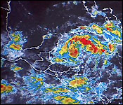
reports from an Air Force Reserve hurricane hunter aircraft indicate
that the low pressure area over the northwestern Caribbean has
developed into Tropical Storm Karl. At 500 PM EDT...2100 UTC...
the center of Tropical Storm Karl was located near latitude 18.3
north...longitude 84.2 west. Karl is moving toward the
west-northwest near 15 mph...24 km/hr...and this general motion is
expected to continue with some decrease in forward speed during the
next couple of days. On the forecast track...the center of Karl
will move over the Yucatan Peninsula on Wednesday...and move into
the southwestern Gulf of Mexico Wednesday night or Thursday.

Maximum sustained winds are near 40 mph...65 km/hr...with higher
gusts. Strengthening is expected before the center of Karl reaches
the Yucatan Peninsula...with weakening forecast after landfall.

At this time...Karl is a small tropical storm. Tropical-storm-force
winds extend outward up to 10 miles...20 km from the center.

The minimum central pressure estimated from the hurricane hunter
data is 1001 mb...29.56 inches.


Hazards affecting land
----------------------
storm surge... a storm surge is expected to produce some coastal
flooding near and to the north of where the center makes landfall.
Near the coast...the surge will be accompanied by large and
damaging waves.

Rainfall...Karl is expected to produce total rain accumulations of 3
to 5 inches over the Yucatan Peninsula...Belize...and northern
Guatemala...with isolated maximum amounts of 8 inches.

[Linked Image]

Joined: Jun 2008
Posts: 17
Offline
gee,it is so sweet that carl and i will arrive at the same time!
hoping it's just a little rain.........

Joined: Oct 1999
Posts: 84,398
Marty Offline OP
OP Offline
from a friend, 25pm

LOVE FM just broadcast local info on TS Karl - briefly the message was:

If Karl stays on track it will land mid-day tomorrow north of Corozal. Tropical force winds extend out only 10-20 miles. Speculation is that the storm's winds won't hit us directly, but that there could be intense thunderstorms that contain bursts of high wind as part of the squalls that move through.

Mariners are advised to come to shore as a precaution.

Weather in the AC area is expected to begin to deteriorate late today, and most of Karl's weather should be out of Belize by Thursday.

LOVE FM will broadcast an update around 6 or 6:30 tonight.

Joined: Oct 1999
Posts: 84,398
Marty Offline OP
OP Offline
NEMO Public Advisory #4

At 3:00 pm Tropical Storm Karl was cantered near latitude 18.3 N, Longitude 84.2 W. This position is about 274 miles east of Corozal Town. Maximum sustained winds are 40 mph moving 15mph and further strengthening is likely to occur. NEMO has put into effect a Tropical Storm Watch from Belize City northward to the Belize/Mexico border.
4 to 6 inches of rainfall is expected, which increases the risk of flooding in the North. The present forecast track takes the system just to the North of Belize with landfall expected around Midday tomorrow (Wednesday).
People along the coast and on the Cayes are encouraged to evacuate early, once NEMO declares a phase.
Motorists are advised that increased rainfall can cause flash flooding and render roads impassable.
The general public is strongly advised to:
Review your emergency plans (family, community, business)
Ensure you have adequate food, water and medicine
Confirm preparations if seeking shelter. Know where you are going and make sure to inform relatives and friends of your plans, whereabouts and intended destination.
The public is further advised to listen to their local radio and television stations for further advisories from the NEMO and the National Met Service.
NEMO remains on high alert as it continues to monitor Tropical Storm Karl. Public Officers are advised to be on standby in the event that they need to report to their assigned emergency duties.
The NEMO hotline number is 636. Please contact your NEMO District Coordinator for local information.

Joined: Oct 1999
Posts: 84,398
Marty Offline OP
OP Offline
[Linked Image]

Statement as of 8:00 PM EDT on September 14, 2010

...Karl a little stronger...heading toward the Yucatan Peninsula...

summary of 800 PM EDT...0000 UTC...information
----------------------------------------------
location...18.4n 84.8w
about 230 mi...370 km E of Chetumal Mexico
maximum sustained winds...45 mph...75 km/hr
present movement...WNW or 290 degrees at 15 mph...24 km/hr
minimum central pressure...999 mb...29.50 inches


Reports from a hurricane hunter aircraft indicate that the maximum
sustained winds have increased to near 45 mph...75 km/hr...with
higher gusts. Some additional strengthening is possible before
the center of Karl reaches the Yucatan Peninsula...with weakening
forecast after landfall.

Joined: Oct 1999
Posts: 84,398
Marty Offline OP
OP Offline
navy rules. they have a heck of a track record.
http://www.nrlmry.navy.mil/tc_pages/tc10/ATL/13L.KARL/ssmi/gif/full/Latest.html

base site: http://www.nrlmry.navy.mil/tc_pages/tc_home.html
click on KARL upper left corner

Joined: Oct 1999
Posts: 84,398
Marty Offline OP
OP Offline
[Linked Image]

700 AM CDT WED SEP 15 2010

...CENTER OF KARL ABOUT TO MAKE LANDFALL ON THE EAST COAST OF THE
YUCATAN PENINSULA OF MEXICO...


SUMMARY OF 700 AM CDT...1200 UTC...INFORMATION
----------------------------------------------
LOCATION...18.6N 87.6W
ABOUT 45 MI...75 KM E OF CHETUMAL MEXICO
MAXIMUM SUSTAINED WINDS...65 MPH...100 KM/HR
PRESENT MOVEMENT...WNW OR 285 DEGREES AT 13 MPH...20 KM/HR
MINIMUM CENTRAL PRESSURE...991 MB...29.26 INCHES

Wind Swath Forecast Map

[Linked Image]

Joined: Oct 1999
Posts: 84,398
Marty Offline OP
OP Offline
Karl has now emerged into the Bay of Campeche and really lost no strength during its passage over the Yucatan Peninsula. Karl has maximum winds this morning of 50 mph. Environmental conditions are very favorable for strengthening and it seems likely that Karl will be a hurricane within the next 24 to 30 hours and will make landfall on mainland Mexico south of Tampico as a upper end Category 1 or perhaps a low end Category 2 hurricane late Friday night or early Saturday morning. Karl poses no threat to the Texas coast or the rest of the US Gulf coast.

Joined: Oct 1999
Posts: 84,398
Marty Offline OP
OP Offline

Tropical Storm Karl leaves Corozal wet, but unharmed

Tropical Storm Karl passed over northern Belize early this morning. The north braced up and prepared; schools closed and shelters were on standby. Karl brought rains, strong winds and a power outage; that was about the worst. A News Five team headed out this morning and found that it was business as usual throughout Corozal Town. News Five's Isani Cayetano reports.

Isani Cayetano, Reporting

The recession of sea followed by heavy winds and a few storm showers in the Corozal Bay overnight were the only visible signs of the passage of Tropical Storm Karl through northern Belize. Despite several bulletins issued by the National Emergency Management Organization it was business as usual in Corozal Town today. The system which was expected to make landfall this morning brought with it minimal damage to property and from the look of things residents in the northernmost reach of the country were prepared to face the weather. According to Willard Levy plans were already in place in the event that residents had to be evacuated.

Willard Levy, District Coordinator, NEMO Corozal

Willard Levy

"Yesterday we [uhm] I called up an emergency meeting at two o'clock just to put the committee in gear to unroll their plan of action noh and [uhm] make sure that everybody is prepared and ready and [uhm] to lay out their plans and put everybody on high alert. I communicated with the village emergency committees because we have an emergency committee in every village in the district here in Corozal and [uhm] also called their attention to be on high alert for the rains and winds that would be coming, you know, during the course of the night and in the day today. And what we did was just that until this morning when the winds and the rains started, strong winds of about thirty-five, forty miles per hour and then we had heavy rains from about nine until eleven-thirty."

By midday the weather was already clearing up; however, along the Northern Highway near the Belize/Mexico Border the aftermath of sustained showers was quite evident. Vehicles had to make their way through several inches of water that settled along the thoroughfare. Levy says they wasted no time in sending out NEMO personnel into flood-prone areas.

Willard Levy

"Medical team had deployed their surveillance committee. [Uhm] transport was ready; everybody was ready and prepared to gear up. Our primary concern was Sarteneja because it's so isolated and when we have heavy rains the road gets impassable so like I said I contacted the chairman of the emergency committee there and [uhm] we found out that we have about, we had about four families that were flooded. Despite, they refused to go into shelters so, but we were all ready and alerted to, if we needed to open shelters we were prepared."

Fortunately there was no need to. In fact residents of Corozal Town were out and about and with classes being cancelled for the day some students went to the beach where they made use of the extra seafront. Damages in the outlying areas, according to Levy, were little to none.

Willard Levy

"The other villages experienced minor things [uhm] but afterwards we got the report that [uhm] we had, after the winds we had some fallen trees, plantain trees, you know, the light trees them and we have that all over the district, you know, in the different areas. Corozal Town has a lot of that if you notice around you we have that kind of situation and [uhm] so what we are trying to do is the Damage Assessment Committee has gone out to make an evaluation of the situation with the papaya industry."

In 2007 the papaya industry was virtually blown away by gale force winds that accompanied Hurricane Dean. Although Karl did not come as close in terms of category and impact, other companies took no chances in safeguarding their facilities.

Willard Levy

"BEL had cut off electricity in the different areas of the town and the district as a matter of fact and [uhm] waiting until NEMO was prepared to say that it's an all clear to restore back electricity and that would be done during the course of the afternoon."

By two o'clock this afternoon power was fully restored in Corozal Town and its surrounding villages. There were no fatalities or significant losses recorded. Reporting for News Five, I am Isani Cayetano.


Joined: Oct 1999
Posts: 84,398
Marty Offline OP
OP Offline

Karl Cometh, (and Goeth) Without Much Fuss

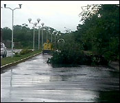
The center of Tropical Storm Karl made landfall 30 miles north of Chetumal this morning after 8:00 am. No major damage was reported in Chetumal - or along the coast of Quintana Roo - which is to say Sam's Club is safe and open for business.

But with winds of 65 miles per hour, the storm did do some damage. Our storm chaser Monica Bodden has been in northern Belize and southern Mexico since morning to see what Karl did. Here's her report.

Monica Bodden, Reporting
Tropical Storm Karl made landfall at 7:45 this morning - about 30 miles east - northeast of Chetumal Mexico. Skies were grey in Corozal Town - when we arrived this morning. Seas where choppy as the winds picked up the atmosphere was indeed gloomy 16:50�. As residents of the Town locked up inside their homes.

All Waiting to see what tropical Storm Karl will bring to our surprise things cleared up a little before 10 o'clock this morning as the rains ceased - the skies cleared up and the winds began to calm down.

We caught up with Mayor of Corozal Town who told us what happened as Tropical Storm Karl brushed Corozal.

Hilberto Campos - Mayor of Corozal Town
"First of all we are very grateful to the good Lord that it hasn't been worse and the storm was being monitored from yesterday from about 2 pm. The NEMO had gathered and we had been looking out for the storm. No life threatening, everything has been restored back in Corozal Town with the exception of the fallen trees as you can see so that's going to be the responsibility for the Corozal Town Council to come and clean up. But we are very glad that it didn't really escalate to any worse proportions."

According to Campus - there hasn't been any major flooding in the Corozal District.

Hilberto Campos - Mayor of Corozal Town
"Not major flooding. There were about 4 different families housed in Sarteneja that were kind of flooded but they refused to leave their homes and they remained there and we are still monitoring the situation whether or not the water will rise and as you can see in Corozal it has already stopped raining. Like I said the only problem now that we have in town is the cleaning up of the town with the fallen trees."

This morning about 11 o'clock there was a small mishap at the Pueblo Veijo Ferry.

Hilberto Campos - Mayor of Corozal Town "We had a situation at the ferry in which the water receded too quickly and the banks of the river were dry and the ferry got stuck with a bus. It only lasted for a couple of hours, we solved the matter and we were glad that it really didn't go worse."

We further made our way to the Corozal Free Zone were workers were sent home. The entire Free Zone was closed for business and no one was allowed to enter.

With maximum sustained winds of up to 65 miles per hour - Tropical Storm Karl did create some damage in Chetumal Mexico. We made our way across the border and this was what we saw.

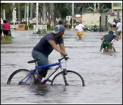
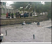
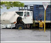
Debris were still lying on the streets of Chetumal trees were rooted up and the streets were flooded, when we got to this pier- fishermen were trying to pull out 6 sunken skiffs from the sea.

The boats were dock were docked at the pier in hopes to weather the storm - as you can see that didn't quite happen. The roof of certain structures were completely destroyed. This billboard couldn't survive the winds.

Cleaning up for the City started early as workers tried moving the fallen trees. This one huge tree is a testament of how strong the winds were gusting. As we patrolled the seaside in water as deep as our knees - all we saw was a lot of fallen trees. And instead of mini taxi's this morning - the locals got around on foot as the entire seaside area was blocked off my police officers.

Channel 7


Link Copied to Clipboard
April
S M T W T F S
1 2 3 4 5 6
7 8 9 10 11 12 13
14 15 16 17 18 19 20
21 22 23 24 25 26 27
28 29 30
Cayo Espanto
Click for Cayo Espanto, and have your own private island
More Links
Click for exciting and adventurous tours of Belize with Katie Valk!
Who's Online Now
0 members (), 131 guests, and 0 robots.
Key: Admin, Global Mod, Mod
Forum Statistics
Forums44
Topics79,205
Posts500,031
Members20,472
Most Online7,413
Nov 7th, 2021


AmbergrisCaye.com CayeCaulker.org HELP! Visitor Center Goods & Services San Pedro Town
BelizeSearch.com Message Board Lodging Diving Fishing Things to Do History
BelizeNews.com Maps Phonebook Belize Business Directory
BelizeCards.com Picture of the Day

The opinions and views expressed on this board are the subjective opinions of Ambergris Caye Message Board members
and not of the Ambergris Caye Message Board its affiliates, or its employees.

Powered by UBB.threads™ PHP Forum Software 7.7.5