
- download large image (4 MB, JPEG, 2743x4072)
- download GeoTIFF file (28 MB, TIFF, 2743x4072)
- download Google Earth file (KML)
Surrounded by darker, deeper ocean waters, coral atolls often glow in vibrant hues of turquoise, teal, peacock blue, or aquamarine. Belize’s Lighthouse Reef Atoll fits this description, with its shallow waters covering light-colored coral: the combination of water and pale corals creates varying shades of blue-green. Within this small sea of light colors, however, lies a giant circle of deep blue. Roughly 300 meters (1,000 feet) across and 125 meters (400 feet) deep, the feature is known as the Great Blue Hole.
The Advanced Land Imager (ALI) on NASA’s Earth Observing-1 satellite captured this image of the Great Blue Hole and Lighthouse Reef in the Caribbean Sea on March 24, 2009. The Great Blue Hole appears at the center of the image, surrounded by a ring of lighter color caused by elevated coral. In fact, parts of the ring surrounding this feature actually crest the water surface at low tide, but a layer of shallow water covers most of Lighthouse Reef Atoll. Boats leave tiny white tracks on the nearby water surface, and two boats appear to travel away from the Hole in this image. East of the boats, a broad band of aquamarine indicates an area of especially shallow water along the reef’s margin. Along its easternmost edge, the reef crests the ocean surface, where breaking waves from the Caribbean Sea form a jagged line of white.
Boats traveling to and from the Great Blue Hole attest to its popularity as a diving site. Besides modern-day marine life, this vertical cave contains remnants from its days above water. When much of Earth’s water was sequestered in glaciers, global sea level was lower. During this time, stalactites or “dripstones” formed inside this cave, and those rocks are preserved underwater today.
Believed to be the world’s largest feature of its kind, the Great Blue Hole is part of the larger Belize Barrier Reef Reserve System, a World Heritage site of the United Nations Educational, Scientific and Cultural Organization (UNESCO).
References
- Belize Audubon Society. (2008). Blue Hole Natural Monument. Accessed April 2, 2009.
- ASTER. (2009, January 23). Great Blue Hole, Belize. Jet Propulsion Laboratory. Accessed April 2, 2009.
- World Heritage. (2009). Belize Barrier Reef Reserve System. UNESCO. Accessed April 2, 2009.
NASA image created by Jesse Allen, using EO-1 ALI data provided courtesy of the NASA EO-1 Team. Caption by Michon Scott.
NASA

Earth From Space: The Great Blue Hole
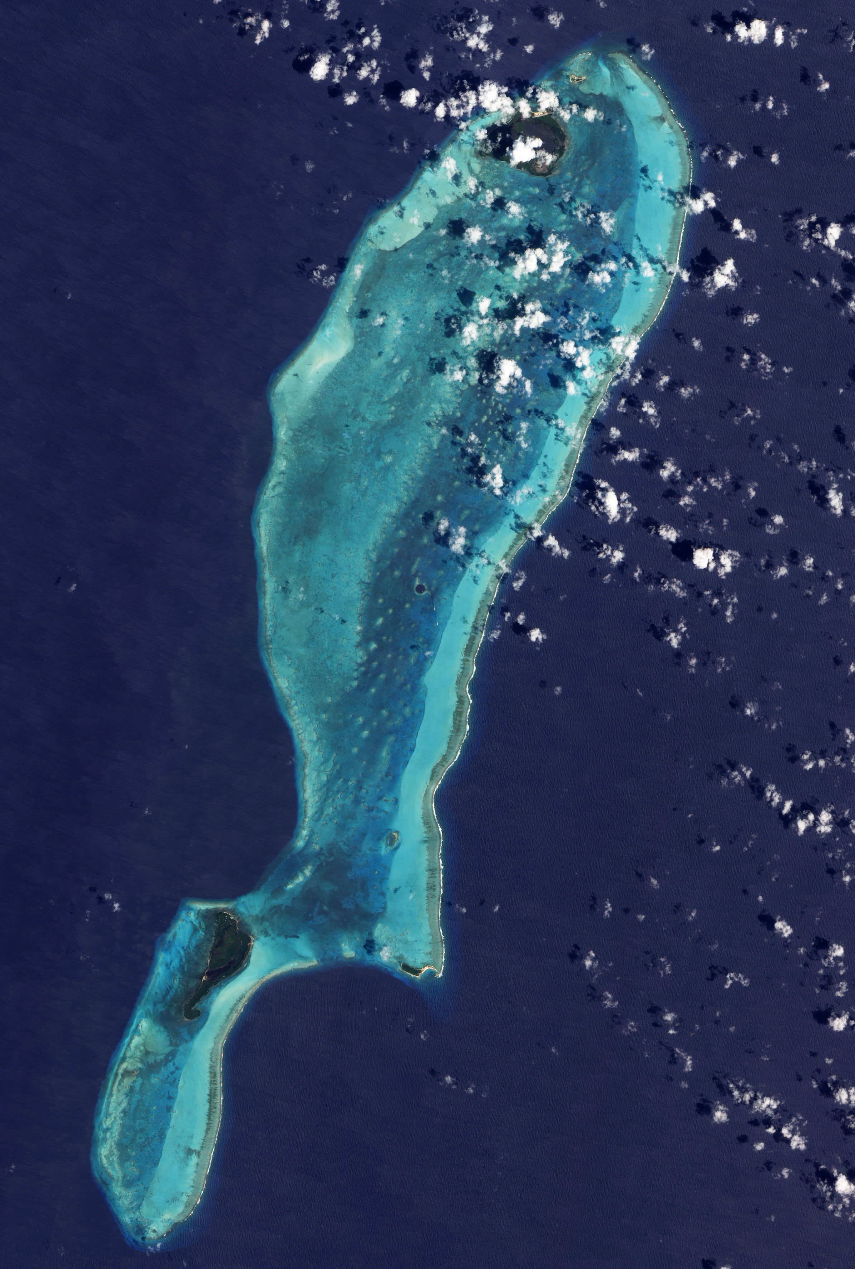
The Lighthouse Atoll in the Belize Barrier Reef is featured in this image acquired by Japan's ALOS satellite.
In the upper-central part of the image, an underwater sinkhole known as the Great Blue Hole appears as a dark blue circle.
Surrounded by the shallow waters of the coral reef, the Great Blue Hole measures over 300 m in diameter and about 123 m deep. Formed when the sea level was much lower, rain and chemical weathering eroded the exposed terrain. Water later filled the hole and covered the area when the sea level rose at the end of the ice age.
Also visible in the image are two coral islands - green with vegetation - called cayes. The larger to the west is Long Caye, and the smaller Half Moon Caye is to the east.
As part of the Belize National Parks, the Half Moon Caye Natural Monument was the country's first protected area. The almost 40 sq km island is an important breeding area for the seabird, the Red-footed Booby.
The greater Belize Barrier Reef has been a UNESCO World Heritage Site since 1996, but in 2009 it was put on the List of World Heritage in Danger. The reef provides a significant habitat for threatened species, including marine turtles, manatees and the American marine crocodile.
The Advanced Land Observing Satellite captured this image on 29 March 2011 with its Advanced Visible and Near Infrared Radiometer, which is designed to chart land cover and vegetation in visible and near-infrared spectral bands, at a ground resolution of 10 m.
Source


