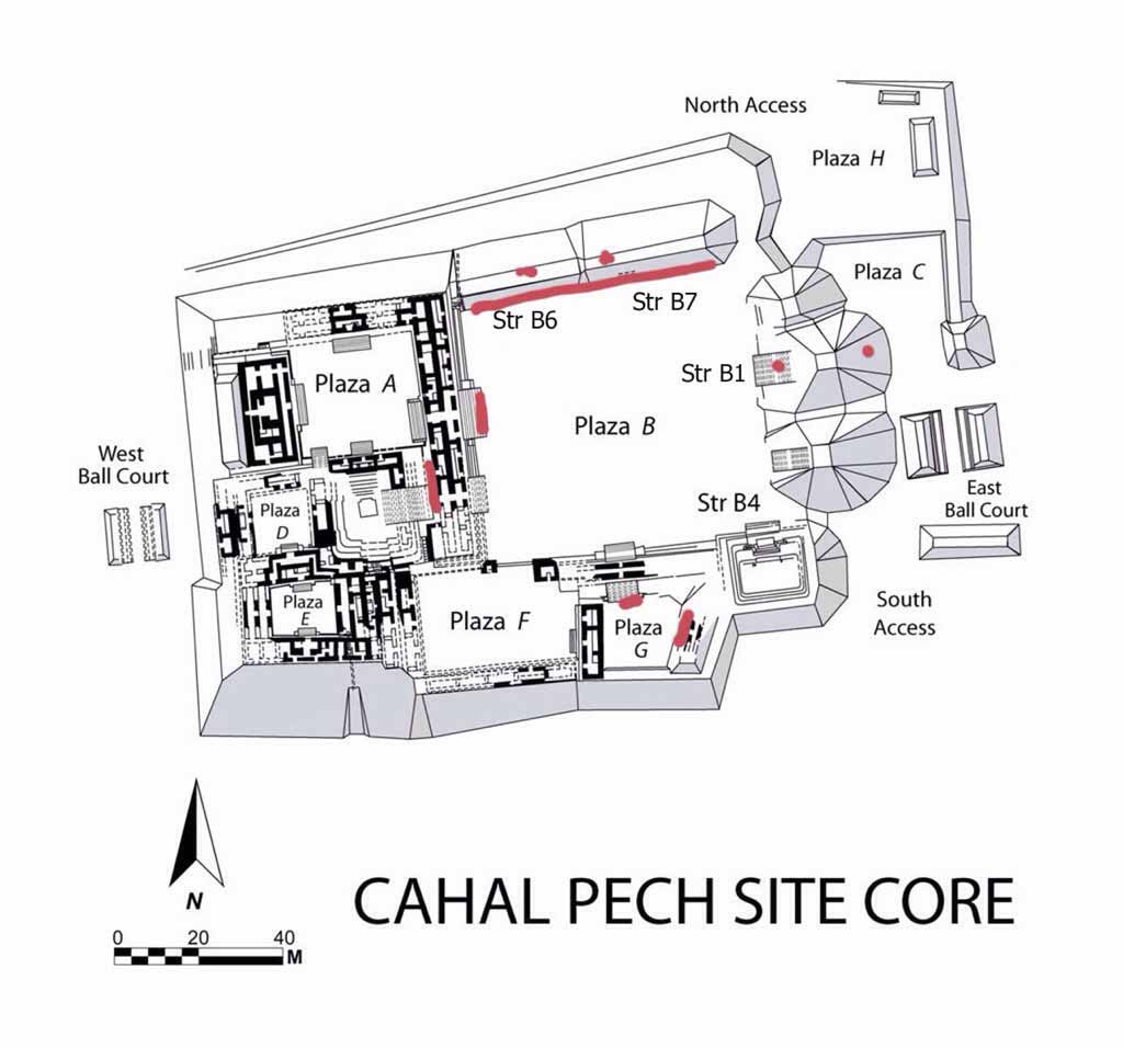
9 Maya Site Maps in Belize Belize is synonymous with pristine; with unspoilt; with Mother Natures best kept secret; with “the nicest people on the planet”; with ancient Maya Cities. Yes, all of the above! When people visit us in our little space on the planet they are absolutely blown away that we have much more than awesome beaches and absolutely splendid places to stay there. They are blown away by the amazing jungle and treks through them and the adventure that sit in wait for them to push the button. We have realised that there is a tremendous amount of reverence that people who visit us pay to the ancient Maya cities that sit in the jungle and coastal settings of our country. Thousands of years of history waiting to be told and we cannot wait to offer the stories to everyone. The following is a listing of small maps for your use when you come visit us to and decide to go to one or more of our Maya Cities. CAHAL PECH (Place of the Ticks)
This little City is snug at the top of a mountain overlooking the towns of San Ignacio and Santa Elena, Cayo. The community has organised itself just around this “Place of the Ticks” as the name translates to English. This name was given to the site because when the researchers first started to work on it, it was the setting of a cattle grazing field and naturally, the ticks. Cahal Pech is also one of the oldest Maya cities organised in Belize…since 1200BC. EL PILAR (The Water Hole)
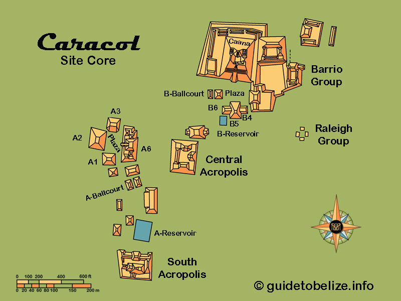
CARACOL (Snail) “Ox Witz a”, the Place of Three Hills – its better known as Caracol. Certainly the name today was given to it because of the roads (especially in 1938) when one would have to go there at a snail-pace. It is the largest Maya City in Belize. It hosts up to 3,000 buildings which would make it about the same size of the great city of Tikal (The Place of Voices) in Guatemala. Caracol had up to 28 Kings that could be counted (maybe even more) but the city was notorious in middle part of the 500’sAD when for example, it helped Calakmul ( a site in Mexico) defeat Tikal.
XUNANTUNICH (Stone Lady) This classic period site os one of the most visited site in Belize. A myth was the design of the name – the 4th name this site has acquired. In 2003, Dr. Jaime Awe, overseeing the Tourism Development Project in Belize, found a piece of a stela, excavating the Castillo that had a name in hieroglyphs which could possibly be the original name for the site: Kat Yatz Witz (Clay is the alms of the mountain) or shortened, Kat Witz, for Clay Mountain.
ALTUN HA (Rock Stone Pond) This is another one of Belize’s most visited sites – especially by Cruise Tourists who get transported to the site from Belize City. This site boasts the find of the largest inscribed jade piece in the Maya world. This jade piece weighed over 9 pounds and the art on it was the likeness of the Sun god, Kinich Ahau (the Lord of the day).
LAMANAI (Submerged Crocodile) This ancient city, located in Orange Walk (Northern Belize) is a popular site in the country (Cruise and overnight visitors). Lamanayan, is the original name and its one of the oldest sites in the country. In fact many cities were abandoned after 900AD and this ancient city was still going strong. In fact, it even has colonial architecture such as the remains of a Spanish Church and even a sugar cane mill.
CERROS (Hills) What a beautiful little place – once a very basic village on one of the most absolutely gorgeous settings, the Corozal Bay, eventually, toward the last part of the pre classic period a king was chosen to manage this city that will control so much of the coastal trade.
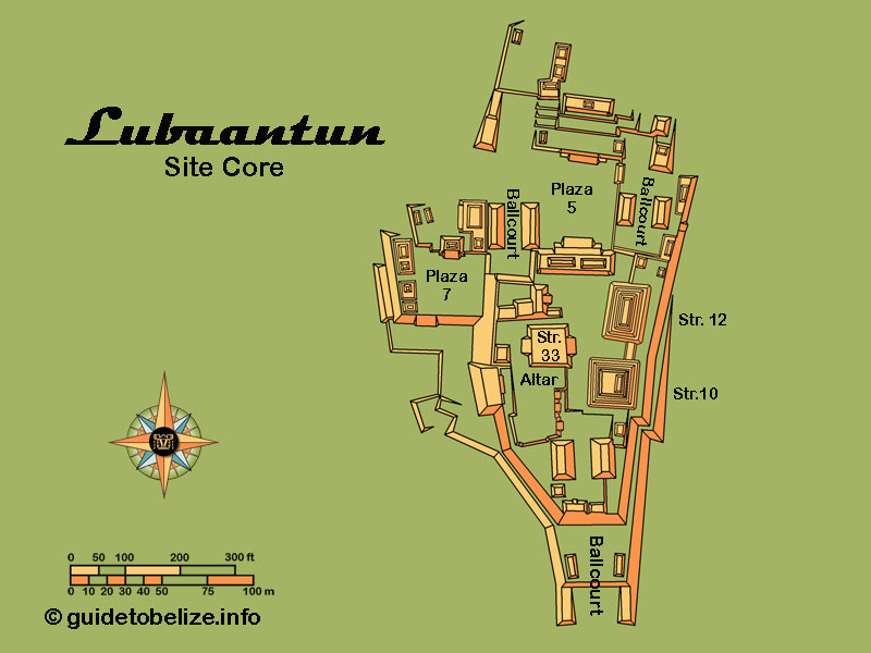
LUBAANTUN (Fallen Stones) This ancient Maya City is an interesting one. All other Maya cities, during their building, rubble fill rocks and cut stone blocks were brought together and secured by mortar – lime – limestone fired over 800 degrees fahrenheit turning it into dust, or cement. This City, interestingly had no such architectural organisation. The buildings were built solely, it seems, by placing rocks on top of each other in shaping the entire building. While the above is fascinating, the “finding” of the Crystal Skull at this site really brought the city to the headlines of newspapers all over the world.
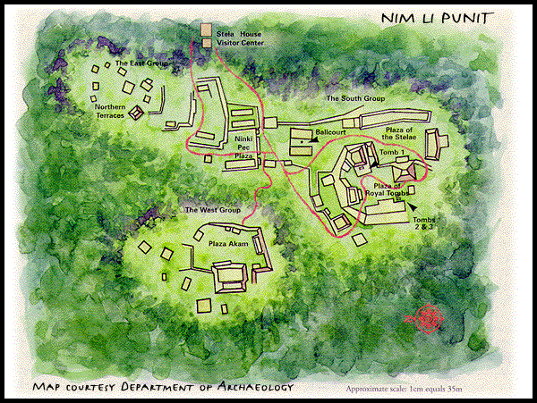
NIM LI PUNIT (Big Hat) This Southern Belize site is impressive in that it is small and it hosted up to 26 stelae. “Big Hat” is the name translation from Kekchi, one of two Maya groups that make Toledo their homeland. The name comes from one of the art piece on a stele with an ancient Maya carved unto a stele with a enormous head dress. Certainly to have that much stelae makes Nim Li Punit an important player in the social and political landscape of the ancient Maya. Something important made this city this prominent
|


|