
Getting 355 and 317 - Maps and Story
MK comments: The three maps, the Operation Commando article, and even the music for this page are from Owen "Reg" Kitchener (#41). The Grid Coordinates are from Sherwin "Arc" Arculis (#6). Both of them gave me much of the information for the comments I am making.
The Operation Commando article (below) tells about the original taking of the two most dominant hills west of the Imjin River and in the area of primary interest ("our hills") to those of us who are in the Bunker.
Hill 355 (Kowang-san) was the lynchpin for holding onto all of "our hills". They include not only those hills in that part of the 1952 front line (MLR) which ran generally in a northeasterly direction from 355 to the Imjin, and the front line outposts in that area, i. e. Kelly et al., but also those hills in that part of the front line which ran on generally in an east-northeasterly direction along the banks of the Imjin and the frontline outposts in that area, and across the river, i. e. Nori et al.
Arc says that Crete is a long narrow feature with several small peaks and that, for its coordinates, he picked the one "most likely". Reg says that Crete got its name from its resemblance, in shape when mapped, to the better known island of the same name, while the 217-317 area bears some resemblance to the "boot" and "heel" of Italy.
Here is a topographical map that
includes all of "our hills" and more:
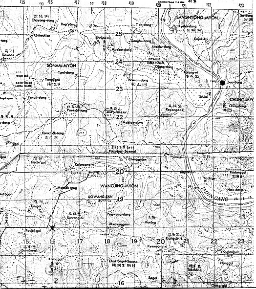
* Nori - CT 214235
* Hill 199 - CT 198209
* Kelly - CT 197223
* Hill 317 - CT179220 (Maryang-san)
* Hill
355 - CT174189 (Kowang-san, a/k/a "Dagmar")
*
Crete - CT173204
* United - CT172218 (a/k/a Sugarloaf)
* Hill 217 - CT169215
* Hill 227: CT158189
I asked Reg for the story to go with his maps. He replied, "Merv, the story is an excerpt from OPERATION COMMANDO. It reads as follows:
The 1st Commonwealth Division
attack was assigned the code name
Operation Commando.
It was planned to ........................

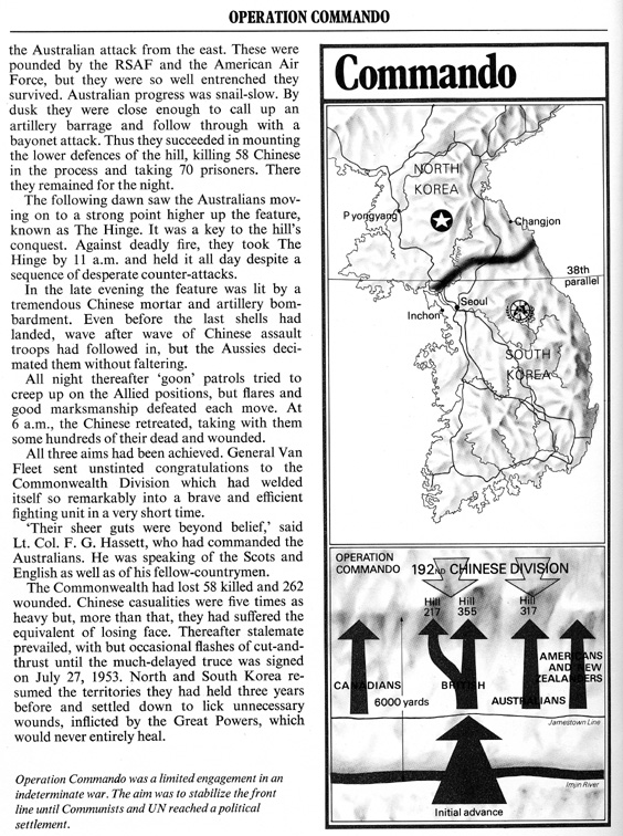
Reg and several others in our Bunker were part of Operation Commando. Arc and many others in our Bunker, including some who, like Arc, were in the 15th Inf Rgt, spent time on 355 after the Operation Commando events. The stories of all the Bunker guys who were on 355 are told at their individual Bunker entries and in the "Can Do" Photo Album.
Hill 355 was counterattacked by Chinese forces several times and was even overrun on a couple of occasions, but only for short periods of time. It was still in the hands of the forces of the United Nations at the time of the final cease fire agreement.
Hill 317 was counterattacked by Chinese forces several times and was finally lost to them for the rest of the war. Bill Ballinger (#38) is one of the few of the Bunker gang who served on the steep slopes of Hill 317. You may click his name and find links to his fine tale told about losing Hill 317 as a result of what the Kosbies (King's Own Scottish Borderers) referred to as "Charlie Chinaman's Gunpowder Plot" carried out on the night of 4/5 Nov 1951, the anniversary of the Guy Fawkes Gunpowder Plot against the British Parliament. After going there, please come right back and visit two Chinese Photo Album pages: Hill 317 Counterattack and Four Maryang-san Photos.
Although a very few in our Bunker
ever actually on the slopes of
317, many of us, who during the winter of 1951-1952 and on through September
of 1952 were doing our jobs in the Kelly et al. area near the Imjin,
lived under the threat of, or the actuality of, taking on fire from
artillery, mortars, machine guns, and (sometimes) even smaller weapons, all of
which were in ample supply to the Chinese on or near 317. I think that the
nineteen Chinese machine guns were still there for sure
![]() .
.
One of these days, if the gods are willing and the creek don't rise, some kind soul will give me the makings for a page which will feature maps and the story about the taking of "our Hills" which lie to the east of 355 and 317. That page, Getting Kelly and Nori - Maps and Story, is sure to be a "keeper".

I
think that the sketch map to your left includes the area that was a part of the
main front line (MLR) from 5 Nov 1951, when Hill 317 was lost, until the end of
the war.
The MLR ran, roughly, from Hill 355 northeast to just west of the "Australia Track" and then on across Hill 199 (marked on the map as "x 199") to the small island in the Imjin. From there, it crossed the river and ran along it's bank to just past Nori.
Outpost Kelly can be located more accurately (by it's grid
coordinates) in the topographical map but, on this sketch map, I am reasonably
sure that Kelly et al. (Breadloaf, Nick, Tessie, and Betty) are located
in the shaded blob just north of Hill 199; and, I think that the Australia path
stayed as the main path from the MLR to all those outposts for the duration.
MK late insert ( 15 Jan 2004): Below is another of Reg's goodies. It gives a more definitive picture of the operation. As an aside, there were many hills in Korea which were referred to at various times and by various units as "Baldy or "Old Baldy". MK.

Kelly and those other outposts west of the Imjin, like 317 (but not 355) in late Nov 1951, were finally lost to the Chinese in late Sep 1952. That story is well told on the page 65th Inf Rgt on Kelly - Map and History.
Nori et al. (Hills 117, 121, and 134) were also finally lost a short time after the loss of Kelly. Some kind soul may tell me that story someday. I got to the Imjin 24 Dec 1951, after Hill 317 was gained and then lost, and left Korea 25 Oct 1952 before Kelly. Like most of the guys (and lads) in our Bunker, I learned nothing about what had happened before I got there, and learned little about what was happening while I was there, except for the events within the area within my view; and, in my case, for nearly half a century I was content to learn nothing more of what happened on those hills before I got there, while I was there, and after I left.
You may visit Cpt Pearson's Map to see a copy of the map he carried on his person while commanding Co A of the 15th Inf Rgt during the winter of 1951-1952 when it was positioned along the banks of the Imjin. On that map, he later marked, for our benefit, the location of more of "our hills" (shown but not marked on this page's maps). They also are marked on the "Our Hills" 1951-1952 Map page linked to below.
There is now a page which tells about the final loss of Kelly. It is the story of the 65th Inf Rgt on Kelly.
![]() 3rd
Division Page
3rd
Division Page
![]() IBB Map and Photo Index
IBB Map and Photo Index
![]() "Our
Hills" 1951-1952 Map
"Our
Hills" 1951-1952 Map![]()
![]() Outpost
Kelly Photo
Outpost
Kelly Photo![]()
![]() Outpost Nori Photo
Outpost Nori Photo
![]()