Late Pliocene to Holocene platform evolution in northern Belize, and comparison with coeval deposits in southern Belize and the Bahamas
S.J. MAZZULLO
Department of Geology, Wichita State University, Wichita, KS 67260, USA (E-mail: [email protected])
ABSTRACT
Lithostratigraphy, depositional facies architecture, and diagenesis of upper Pliocene to Holocene carbonates in northern Belize are evaluated based on a ca 290 m, continuous section of samples from a well drilled on Ambergris Caye that can be linked directly to outcrops of Pleistocene limestone, and of overlying Holocene sediments. Upper Pliocene outer-ramp deposits are overlain unconformably by Pleistocene and Holocene reef-rimmed platforms devoid of lowstand siliciclastics. Tectonism controlled the location of the oldest Pleistocene platform margin and coralgal barrier reef, and periodically affected deposition in the Holocene. A shallow, flat-topped, mostly aggradational platform was maintained in the Holocene by alternating periods of highstand barrier-reef growth and lowstand karstification, differential subsidence, and the low magnitude of accommodation space increases during highstands. Facies in Pleistocene rocks to the lee of the barrier reef include: (i) outer-shelf coralgal sands with scattered coral patch reefs; (ii) a shoal–water transition zone comprising nearshore skeletal and oolitic sands amidst scattered islands and tidal flats; and (iii) micritic inner-shelf deposits. Four glacio-eustatically forced sequences are recognized in the Pleistocene section, and component subtidal cycles probably include forced cycles and autocycles. Excluding oolites, Holocene facies are similar to those in the Pleistocene and include mud-mounds, foraminiferal sand shoals in the inner shelf, and within the interiors of Ambergris and surrounding cayes, mangrove swamps, shallow lagoons, and tidal and sea-marginal flats. Meteoric diagenesis of Pliocene and Pleistocene rocks is indicated by variable degrees of mineralogic stabilization, generally depleted whole-rock d18O and d13C values, and meniscus and whisker-crystal cements. Differences in the mineralogy and geochemistry of the Pliocene and Pleistocene rocks are attributed to variable extent of meteoric alteration. Dolomitization in the Pliocene carbonates may have begun syndepositionally and continued into the marine shallow-burial environment. Positive dolomite d18Oand d13C values suggest precipitation from circulating, near-normal marine fluids that probably were modified somewhat by methanogenesis. Sedimentologic and diagenetic attributes of the Pliocene–Pleistocene rocks in the study area are similar to those in the Bahamas with which they share a common history of sea-level fluctuations and climate change.
Keywords Belize, dolomitization, platform evolution, Pliocene to Holocene, rimmed platform, tectonics.
INTRODUCTION
Sedimentologic analysis of extant carbonate platforms provides critical comparative models for understanding ancient platforms (Read, 1985; Schlager, 1992), and perhaps the most extensively studied modern platform from the viewpoint of its evolution and development is the Bahama Banks (Ginsburg, 2001a). Belize, Central America, is also a major carbonate platform in the western hemisphere, and it has been the site of lowstandpunctuated, platform carbonate deposition since the Cretaceous (Vinson, 1962; Bishop, 1980; Salvador, 1987; Rao & Ramanathan, 1988; Mora´n-Zenteno, 1994). There are many sedimentological studies of Holocene shallow-marine and upper fore-reef deposits on the Belize platform (e.g. Ebanks, 1975; High, 1975; Purdy et al., 1975; Pusey, 1975; James & Ginsburg, 1979; Wilhite & Mazzullo, 2000; Mazzullo et al., 2003; Purdy & Gischler, 2003; Yang et al., 2004). In contrast, much less is known about its platform evolution, and what has been published has focused mainly on subsurface upper Quaternary deposits in the central and southern shelf areas of the country (Fig. 1). Early studies (Choi, 1981; Choi & Gins-burg, 1982; Choi & Holmes, 1982) evaluated lithostratigraphy, facies patterns and platform development based on analysis of seismic profiles coupled with some drill logs and shallow cores. Subsequent research, including high-resolution seismic sequence-stratigraphic studies (Westphall, 1986; Esker et al., 1998; Ferro et al., 1999), described inter-relationships among mixed carbonate–siliciclastic facies architecture, development of incised valleys and valley-fill systems, sea-level fluctuations, and tectonics. Although these studies provided a carefully documented view of upper Quaternary platform and fore-platform evolution in Belize, they encompassed only part of the extensive Belize platform and only that of Late Quaternary age. Whether their conclusions are applicable to the northern shelf area as well is uncertain, however, especially considering known along-strike (N–S) variations in antecedent topography, water depth, proximity to a siliciclastic source and inferred tectonic influence on deposition in these areas (Purdy, 1974b; Purdy et al., 1975, 2003; Purdy & Gischler, 2003).

The present study of the sedimentary architecture and evolution of upper Pliocene to Holocene depositional systems in northern offshore Belize generates a more complete synthesis of platform evolution here. It also contributes to the knowledge of controls on platform evolution in the geologic record (Tucker, 1985; Schlager, 1992; Handford & Loucks, 1993; Read et al., 1995) and to concepts useful in petroleum exploration (e.g. Bishop, 1980; Pindell, 1991). The approach of this paper is threefold. First, it defines the lithostratigraphic and temporal framework of pre-Holocene strata based on integration of a 284 m thick section of cut samples of Late Pliocene to Pleistocene age from a well drilled on Ambergris Caye (the ‘Airstrip well’), and a ca 4Æ7 m thick outcrop section of Pleistocene limestone. Secondly, it interprets the pre-Holocene depositional environments, and their geochemical evolution in terms of dolomite occurrence and stable oxygen and carbon isotope stratigraphy. Thirdly, these data and interpretations serve as the basis for evaluating platform evolution from the Late Pliocene to the Holocene, and for comparing such to platform development in central to southern Belize and to coeval deposits in the Bahama Banks – the latter area commonly considered to be the ‘type locality’ of western hemisphere platforms.
GEOLOGICAL SETTING
The geological setting and general stratigraphy of Belize were summarized most recently by Lara (1993), Purdy et al. (2003) and King et al. (2004). Belize is located at the southern end of the Yucatan Peninsula, which is a low-relief area of highly karsted, undeformed Tertiary and Quaternary carbonates. The oldest rocks exposed on the mainland are in the Maya Mountains (Fig. 1), the primary source of siliciclastics in the region. Silurian to Devonian granites are overlain by Upper Carboniferous to Middle Permian sedimentary, meta-sedimentary and volcanic rocks that, in turn, were deformed and intruded by granite during the Triassic. Surrounding the Maya Mountains are largely undeformed Jurassic siliciclastics, and Cretaceous to upper Tertiary carbonates with some evaporites. Pleistocene carbonate rocks are present mainly in low-lying areas along the coast, and are associated with siliciclastics in the central and southern parts of the country.
Belize lies atop the North American Plate in a passive-margin setting. Rifting in the area began during the Late Triassic and continued into the Cenozoic as the Caribbean Plate migrated eastwards (Bishop, 1980; Salvador, 1987; Pindell, 1991). Cenozoic tectonism in Belize involved faulting (left-lateral and transtensional strike– slip), uplift and compressional folding, and development of the major structural features of the area (Dillon & Vedder, 1973), including the fault-bounded, modern reef-rimmed platform edge (Fig. 1). Tectonic activity diminished after the Oligocene (Bishop, 1980), and although northern offshore Belize is now seemingly tectonically quiescent, there is offshore subsidence and documented movement along some of the faults in central to southern Belize and on some of the offshore atolls (Dillon & Vedder, 1973; Lara, 1993; Purdy et al., 2003).
STUDY AREA, SAMPLES AND METHODS
The study area is centred on and around Ambergris Caye on the northern shelf, distal from a current source of siliciclastics in the Maya Mountains (Fig. 1). Bedrock within the shallow marine (< 5 m) environment around the caye is locally overlain by buried soil and/or mangrove peat, and in turn, by Holocene carbonate sediments, the study of which (Fig. 2, inset; Mazzullo et al., 2003; Yang et al., 2004) forms the basis for interpreting pre-Holocene rocks. The bedrock is highly karsted limestone that rises to a maximum elevation, on Ambergris Caye, of ca 2Æ4 m above sea level. One hundred and sixty samples comprising a total of ca 4Æ7 m of section were collected from outcrops on Ambergris and adjoining cayes, from sea-floor exposures in shallow marine areas, and from blocks of limestone brought to the surface during commercial excavation or dredging activities (Fig. 2). Samples were described in the field and laboratory, and representative samples were examined via thin-section petrography. Three seemingly unaltered samples of the fossil coral Montastrea annularis were dated by U–Th series by Ken Rubin (SOEST/ University of Hawaii), and two unaltered samples of the gastropod Strombus gigas were dated by amino acid racemization by Colin V. Murray-Wallace (University of Woolongong, Australia). These specimens were collected from limestone exposed at Reef Point and along the Basil Jones transect on Ambergris Caye, respectively (Fig. 2), and their mineralogy was 100% aragonite as confirmed by X-ray diffraction (XRD).
A 284 m deep well – the ‘Airstrip well’ – was drilled in 1991 by the Belize Water and Sewer Authority (WASA) adjoining the airstrip south of San Pedro Town on Ambergris Caye, ca 1Æ1km leewards of the platform margin (Fig. 2). It spudded in Holocene beach sand and penetrated the top of the limestone bedrock of the caye at )2m, which coincides with mean sea level (MSL). Except for some sections of no recovery, cuttings were collected every 3 m during drilling, and they were later described via binocular microscopy and thin-section petrography. The upper 2Æ3m of samples in this well correlate to the basal 2Æ3m of shallow-subsurface Pleistocene limestone that were sampled (Fig. 3A), thus providing a critical and uninterrupted link between deeper samples in the Airstrip well and outcrops in the study area. Wire line logs were not run on the well, and bore-hole fluids (described by the drillers as ‘salty water’) were not sampled by WASA. A subset of cuttings was sent to Barbara Lidz (US Geological Survey) for identification and age assignment of benthic foraminifera. Dolomite was identified in the well samples, and it was isolated following the procedure in Teal et al. (2000). Only samples that were shown by XRD to comprise 98% or more dolomite were sent to the Stable Isotope Laboratory, University of Michigan-Ann Arbor for stable isotope analysis. A subset of whole-rock samples from the well was also analysed for O and C isotopic composition. External reproducibility for d18O and d13C analyses (PDB) is less than 0Æ1&; corrections are not applied for dolomite– phosphoric acid fractionation in dolomite d18O values.
Fig. 2. Distribution of bedrock limestone exposed on and around Ambergris Caye, sample locations, and locations of the Airstrip well and the Gulf Oil no. 1 Basil Jones well. Inset – locations of samples of Holocene carbonate and associated sediments (from Mazzullo et al., 2003 and Yang et al., 2004).
X-ray diffraction of Holocene sediments and alpha radiation with internal quartz standards surface and subsurface rocks was carried out on a added. Mol.% MgCO3 in calcite and dolomite was Phillips 3100XRG diffractometer utilizing Cu–K determined by the [1 0 4] peak shift method
Fig. 3. (A) Composite stratigraphic section in northern Belize based on the Airstrip well and exposures on and around Ambergris Caye, proposed stratigraphic terminology, and vertical range of basal Late Pliocene benthic foraminifera. Uppermost beds of the Ambergris Caye Limestone exposed on Ambergris Caye contain age-dated corals assigned to Late Pleistocene (Sangamon) oxygen isotope stage 5e. (B) Stratigraphy of northern Belize (Corozal Basin), no vertical scale, from Purdy et al. (2003), who placed upper beds in the Gulf Oil no. 1 Basil Jones well on Ambergris Caye (shown in Fig. 2) within the Eocene Doubloon Bank Formation. Note the prominent ‘Belize unconformity’ at the top of the Pliocene, which correlates to the unconformity at the top of the Pliocene in the Airstrip well.
following Mackenzie et al. (1983) and Lumsden & Chimahusky (1980), respectively. Radiocarbon dating of Holocene mangrove peat and associated samples was carried out by Geochron Laboratories, and the ages reported are uncorrected for reservoir effect.
STRATIGRAPHY OF PRE-HOLOCENE SUBSURFACE AND EXPOSED ROCKS
The section in the Airstrip well, together with the exposed and near-surface limestones present on and around Ambergris Caye, has a total thickness of nearly 290 m of pre-Holocene strata (Fig. 3A). This section is divided into the following lithologic units in ascending stratigraphic order. Formal names are proposed to clarify the vague and poorly documented stratigraphic assignments and terminology in this part of the section.
San Pablo Limestone
This unit, the base of which was not encountered in the well, consists of 95 m of greyish light tan, silty (maximum 10% by weight of detrital quartz, and in the basal 83 m of section, also detrital biotite) and slightly cherty, soft and ‘chalky’, nonporous, dolomitic limestone with scattered nodules of replacive celestite. The replacive dolomite is finely crystalline (mean size 15 lm), and the unit coarsens upwards slightly from mudstones with miliolids and diatoms to wackestones with similar allochems and rare coral and thin-shelled bivalve fragments.
San Pedro Limestone
This unit consists of 55 m of light grey to greyish tan, non-porous, dolomitic limestone with red algae, echinoid spines, minor to rare corals, miliolids and rare soritids, abundant pyritized peloids in upper beds, and scattered fragments of crab carapaces. Ramose and encrusting red algae are particularly abundant in the upper 15–20 m. Texture coarsens upward, and the replacive dolomite is finely crystalline (mean size 15 lm). Minor chert nodules are present towards the base.
Airstrip Limestone
This section comprises 105 m of white and some yellowish-tan, porous limestone with corals, red algae, Halimeda, Homotrema, soritid and miliolid foraminifers, and gastropod and pelecypod fragments. Ramose and encrusting red algae are abundant in the basal 25–30 m. Texture coarsens upwards from packstones with thin interbeds of grainstone in the lower half, to overlying pack-stones and grainstones.
Ambergris Caye Limestone
The uppermost unit in the Airstrip well is 28 m thick, and consists of mostly white and light tan, porous limestones that generally coarsen upwards from wackestones/packstones to pack-stones/grainstones. Constituent particle size and the amount of corals and associated coralline algae, Halimeda, Homotrema and thick-shelled pelecypods and gastropods increase upwards. Of the total vertical section of ca 4Æ7 m of limestones that was compiled from exposures and excavated and/or dredged samples on and around Ambergris Caye, the basal 2Æ3 m correlate to the limestone section of the same thickness at the top of the Airstrip well (Fig. 3A). These rocks and the overlying 2Æ4 m of exposures on and around the caye are included within the Ambergris Caye Limestone to give it a total thickness of ca 30 m. Flores (1952) referred to exposures of coral-rich rocks along the north-eastern coast of Ambergris Caye (e.g. at Reef Point: Fig. 2) as the ‘Ambergris reef limestone’, from which the name of the present formation is derived.
AGES AND CORRELATION OF PRE-HOLOCENE ROCKS IN BELIZE
In the Airstrip well, samples of unaltered skeletal material, mud matrix, or marine cements suitable for radiometric dating or 87Sr/86Sr isotope analyses were not available, and absence of cores precludes magnetostratigraphic dating. Only bank-top (shallow-water) foraminifers that are not age-diagnostic are present in well samples in the Ambergris Caye Limestone down to the upper San Pedro Limestone. Biotic particles are poorly preserved in the middle to lower San Pedro Limestone and upper San Pablo Limestone, but the lower half of the San Pablo Limestone (232–286 m depth: Fig. 3A) contains basal Late Pliocene planktic foraminifers assignable to biozone N20 (3Æ5to2Æ5 Ma) of Bolli & Saunders (1985). Based on lithologic similarity of the San Pablo and San Pedro dolomitic limestones and the abrupt change to limestone above, the top of the Pliocene is placed at the top of the dolomite. Lara (1993) documented a similar mineralogic relationship between Pliocene and Pleistocene rocks in the subsurface in southern Belize. The inferred unconformity at the top of the San Pedro Limestone therefore probably correlates to: (i) the ‘Belize unconformity’ recognized in subsurface central and southern Belize (Esker et al., 1998; Ferro et al., 1999; Purdy et al., 2003); (ii) the unconformity at the top of the Pliocene recognized in subsurface southern Belize (Choi & Ginsburg, 1982; Choi & Holmes, 1982); and (iii) to the global sea-level lowstand at the top of the Pliocene (Haq et al., 1988).
The limestone exposed on and around Ambergris Caye, which encompasses the top 4Æ7m of the Ambergris Caye Limestone, has long been regarded as Pleistocene (e.g. Flores, 1952; Ebanks, 1975; Pusey, 1975). A Sangamon age was suggested by Tebbutt (1975) based on apparent correlation to ca 125 000 year old deposits in the Bahamas and elsewhere. In the present study, a sample of M. annularis in limestone at 0Æ5m above MSL at Reef Point (Fig. 2) yielded a U–Th age of 135 800 ± 900 cal yr BP (Table 1). Thorium content is at the high end of the normal range for corals, which may account for a U–Th age slightly older than the age of 128 280 ± 1330 cal yr BP obtained from a fossil Acropora palmata, collected from 0Æ3 m above MSL also at Reef Point by Gischler et al. (2000). Together, however, these age dates establish that at least the upper part of the Ambergris Caye Limestone is within oxygen isotope stage 5e (Sangamon highstand) of Late Pleistocene age. Preliminary amino acid racemization results (d/l ratios for the total acid hydrolysate: Table 1) suggest that two samples of Strombus gigas in limestone at 1Æ2 m above MSL along the Basil Jones traverse (Fig. 2) likewise are within stage 5e. The other sample of M. annularis that was U– Th age-dated was from limestone dredged from 2Æ3 m below the surface on southern Ambergris Caye. Its U–Th age of 165 500 ± 1100 cal yr BP is considered unreliable given the relatively high Th content (Table 1).
The Pleistocene age of the Airstrip Limestone in the well and all but the top 2Æ3 m of Sangamon-age Ambergris Caye Limestone remains equivocal. This section correlates to the upper part of the subsurface Belize Formation, above and immediately below the ‘Belize unconformity’, as is recognized in the northern part of the country (Fig. 3B). Accordingly, previous assignments of outcropping and relatively shallow subsurface strata in northern offshore Belize as Eocene (e.g. Dillon & Vedder, 1973; Bishop, 1980), undivided Tertiary (Purdy, 1974a,b; Ferro et al., 1999, their fig. 2), or undivided Quaternary (Rao & Ramanathan, 1988), and likewise, their correlation to the Barton Creek Formation (Rao & Ramanathan, 1988), are not warranted. Assignment of at least shallow (to ca 450 m depth) subsurface strata in the Gulf Oil no. 1 Basil Jones well on Ambergris Caye to the Eocene Doubloon Bank Formation (Purdy et al., 2003, their fig. 3A) likewise is not justified. It is proposed that the Belize Formation in northern Belize be restricted to pre-Pleistocene strata, with the San Pablo and overlying San Pedro limestones comprising its upper members (Fig. 3A). The overlying Airstrip and Ambergris Caye limestones are thus considered to be formations that correlate to strata (unnamed in Purdy et al., 2003, their fig. 2) above the Belize unconformity, and to Pleistocene carbonate and siliciclastic deposits in the subsurface
Table 1. Age-dated samples from bedrock limestone exposures on Ambergris Caye (this study). U-Th series dates from Ken Rubin, University of Hawaii, and amino acid racemization data from Colin V. Murray-Wallace, University of Woolongong, Australia. Elevations are with respect to mean sea level.
Detrital Sample Location Elev 230Th/238U Age Correction Remarks
U-Th Series Dating
M. annularis (KW-90) Reef Point +0Æ5m 0Æ800 ± 0Æ004 135,800 BP ± 900 0.1% 450 yr Reliable
M. annularis (KW-111) Dredge, so. )2Æ3m 0Æ897 ± 0Æ005 165,500 BP ± 1100 1% 4600 yr Unreliable Ambergris Caye
Sample Location Elevation D/L LEU (leucine) D/L ASP (aspartic acid) Remarks
Amino Acid Racemization
S. gigas (KW-30A) Basil Jones +1Æ2m 0Æ44 ± 0Æ01 0Æ56 ± 0Æ04 Likely O isotope stage 5e
S. gigas (KW-30B-1) Basil Jones +1Æ2m 0Æ42 ± 0Æ01 0Æ60 ± 0Æ05 IBID
of central and southern Belize (Choi, 1981; Choi & Ginsburg, 1982; Choi & Holmes, 1982; Esker et al., 1998; Ferro et al., 1999).
DEPOSITIONAL FACIES AND DIAGENESIS OF PRE-HOLOCENE STRATA
Sediments and biota of Holocene age in northern offshore Belize have been examined by many researchers, including Ebanks (1975), High (1975), Pusey (1975), Mazzullo et al. (1987, 1992, 2003), Dunn (1990), Birdwell (1992), Mazzullo & Bischoff (1992), Lowe (1995), Burke et al. (1998), Teal (1998), Teal et al. (2000), Wilhite (2000), Wilhite & Mazzullo (2000), Dimmick-Wells (2002), Purdy & Gischler (2003), Gischler & Hudson (2004), and Yang et al. (2004). Accordingly, Holocene facies in northern Belize are well known among sedimentologists. The sedimentologic and biotic attributes of these deposits are summarized in Table 2, and they provide the analogues for interpreting Pliocene and Pleistocene environments in outcropping and subsurface limestones in the study area.
Depositional environments and geochemistry of rocks in the Airstrip well
Upper Pliocene outer-ramp deposits
Upper Pliocene strata in the basal part of the Airstrip well are lithologically and biotically distinct from overlying Pleistocene coral-rich limestones (Fig. 4). The basal San Pablo Member, for example, is slightly cherty and silty (10–15% detrital quartz and biotite) dolomudstone with sparse miliolids and diatoms. This section coarsens upwards to include interbedded dolopackstones and grainstones in the upper part of the San Pedro Member, with increasing amounts of ramose and encrusting coralline algae and pyritized peloids, and lesser amounts of echinoid spines, miliolids, soritids, bivalves, and minor sand-to fine gravel-size coral fragments. The packstones and grainstones are typically fine-grained and generally contain particles that are smaller than coarse sand to fine gravel. Muds and fine-grained sands similarly are present in deep water, fore-reef slope settings surrounding, but somewhat distal from, extant carbonate platforms
(e.g. Coniglio & Dix, 1992). The San Pablo and San Pedro limestones cannot be considered fore-reef deposits adjoining a reef-rimmed platform, however, given that coeval platform-marginal coral reef deposits of Pliocene age have not been identified either in the study area or in up-dip locations on the Belize mainland to the west (Wright et al., 1959). Rocks possibly of this age on the mainland are mainly nearshore sands and marls (King et al., 2003, 2004). Secondly, coarse-grained coral and Halimeda-rich rocks that typically comprise upper fore-reef lithologies in Belize (e.g. James & Ginsburg, 1979) and elsewhere are not present in the Airstrip well section. Instead, the San Pablo and San Pedro Members are interpreted as shallowing-upward, outer-ramp deposits based on: (i) the biota present; (ii) rarity of corals, (iii) the fine-grained lithology of the rocks; and (iv) the supposition that the Pliocene and Pleistocene sections are disparate depositional systems separated by an unconformity. These rocks have no facies counterpart in the Pleistocene (Sangamon) limestones or Holocene sediments in the study area.
A major unconformity at the top of the Pliocene is recognized in outcrops over much of the Yucatan Peninsula (Wright et al., 1959; Vinson, 1962). In contrast, Pliocene rocks are present in the subsurface in northern offshore Belize (this paper) and central to southern Belize (Purdy, 1974a,b; Choi & Ginsburg, 1982; Lara, 1993; Esker et al., 1998; Ferro et al., 1999; Purdy et al., 2003), which indicates that these areas were subsiding at the time. The quartz–biotite silt in the San Pablo and San Pedro Members was ultimately derived from the Maya Mountains to the south-west, and its presence supports Purdy et al.’s (2003) contention that this source area was unroofed at least by early Late Pliocene. An unconformity at the top of the upper Pliocene San Pedro Member in the Airstrip well (Fig. 3A) is suggested by a pronounced facies disparity between coral-poor packstones/grainstones in slope strata of the upper San Pedro Member and the interbedded wackestones/packstones with relatively abundant corals and other shallow-water biota in inferred platform strata of the overlying basal Airstrip Formation. Alternatively, it is possible that this contact is a correlative conformity down-dip of the major unconformity recognized on the mainland. Additional unconformities that are not readily identifiable in the well samples by lithic evidence (such as is present in the Pleistocene section) may also be present in the Pliocene rocks, particularly at the base of sections where there is an abrupt increase in the amount of MgCO3 in component calcites (e.g. at ca 155, 220 and 270 m: Fig. 5A). A shift to lower whole-rock d18O and d13C values at 155 m and 270 m depths
Table 2. Characteristic lithology and biota of Holocene surficial and shallow-buried depositional environments, excluding the barrier reef (facies 1 – see Fig. 7B).
Environment Facies1 Lithology and common biota
Outer-shelf facies Marine sand tract 2 Generally gravelly sand, more gravelly towards barrier reef and finer-grained toward land. Aside from coral fragments and sponges, accessory common biota are Halimeda spp., Neogoniolithon spp., Penicillus spp. and Udotea spp.; Homotrema rubrum; Strombus gigas,
S. pugilis, S. costatus and S. raninus, Turbinella angulata, Vasum muricatum, various tritons, cowries, cone shells, top shells, star shells, helmet shells and limpets; Apolymetis intastriata, Macoma constricta, various lucines including Codakia spp., various tellins, cockles, ark shells and thorny oysters; various urchins and sea stars (e.g. Diadema, Meoma, Brissus and Oreaster); grassy areas with Thalassia and Syringodium
Beach 2 Relatively fine-grained sand with biota as above Storm rubble ridge – Coarse gravel to boulder-size particles, dominantly stony corals at Robles Point (e.g. M. annularis, M. cavernosa, Diploria spp., Agaricia spp., Acropora palmata, A. cervicornis and Porites spp.), gastropods (e.g. S. gigas and
T. angulata), gorgonians; various sponges; and organisms listed above
Sponge bioherm 2a Sand and gravelly sand with Ircinia campana and other sponges; algae, gastropods and pelecypods as in facies 2; Caulerpa spp. and some Thalassia; Porites spp., Manicina areolata, and Siderastrea siderea; Pinna carnea
Facies on Ambergris and other cayes Intra-caye lagoons 3 & 4 Sandy and slightly gravelly mud (facies 3) and muddy molluscan gravel (facies 4) with miliolids and soritids; Chione spp., Anomalocardia spp., various tellins, lucines and mussels; M. melongena, murex shells, various cerithids, batillarids and horn shells, Fasciolaria tulipa Mangrove swamps – Peats with Pseudocyrena floridana, Melongena melongena, and various cerithids, batillarids and mangrove oysters (Isognomon alatus) Tidal and sea-marginal – Mud, mainly slightly gravelly and sandy mud, and some muddy and flats slightly gravelly sand with biota as in facies 3 and 4 and as in mangrove swamps Transitional outer to – Buried on southern Ambergris Caye – mainly skeletal gravel with mixture inner shelf of biota listed above in outer-shelf, intra-caye lagoon, mangrove swamp, and tidal-and sea-marginal flat facies Mud mounds 5 Inner-shelf (Bulkhead Shoals) and transitional outer shelf–inner shelf (Cangrejo Shoals): dominantly mud, sandy mud, and muddy sand dominantly with soritids and miliolids and accessory Chione spp., various cerithids, tellins, Thalassia
Inner-shelf facies Muddy gravel 4 Muddy gravel dominantly with pelecypods and gastropods listed below in facies 7, and some miliolids and soritids Miliolid facies 6 Dominantly mud with miliolids Foraminiferan sand shoals 7 Dominantly soritids, accessory miliolids; pearl oysters (Pinctada imbricata), & inter-shoal deposits mussels (e.g. Brachidontes spp.), Chione spp., scallops and Anomalocardia spp.; Bulla striata, murex shells, F. tulipa, M. melongena and various cerithids and batillarids; various tellins and egg cockles Brachidontes gravel 8 Muddy sand and gravel with abundant Brachidontes spp., soritids, and accessory biota as listed under facies 7 Muddy sand to sandy mud 9 Muddy sand to sandy mud dominantly with soritids, miliolids, accessory
M. melongena, Chione spp., Anomalocardia spp. and fragments of thin-shelled pelecypods; and various cerithids and batillarids Sandy mud 10 Sandy mud dominantly with peloids, miliolids and some soritids;
ostracodes; and fragments of thin-shelled pelecypods Mainland beach 11 Fine sand dominantly with miliolids and molluscs as listed in facies 9
In reference to numbered facies in Fig. 7B. Some facies are not shown in Fig. 7B, and hence, are not numbered here.
2006 The Authors. Journal compilation 2006 International Association of Sedimentologists, Sedimentology, 53, 1015–1047
Fig. 4. Lithologic and biotic attributes of subsurface Pliocene and Pleistocene rocks in the Airstrip well (excluding surface exposures), and inferred unconformities, depositional environments, and hierarchal cycles; refer to Fig. 3 for lithologic legend. Particles are listed in order of decreasing abundance; and under ‘Texture’, M-W-P-G refers to mudstone, wackestone, packstone and grainstone, respectively. See Fig. 7A for continuation of sea-level cyclicity into the Holocene.
Fig. 5. (A) Mineralogy of subsurface limestones and dolomitic limestones, excluding Pleistocene outcrops (see Fig. 6B for those data); and whole-rock d18O and d13C values in the Airstrip well (black circles) and exposed Sangamon limestone (open circles). Short-term trends in 13C values are indicated by arrows. (B) d18O and d13C values and Mg concentrations in dolomite in Pliocene rocks. Short-term trends in isotopic composition are indicated by arrows.
may reflect the presence of such unconformities. The rarity, in the rocks, of petrographic features indicative of subaerial exposure, such as meniscus and whisker-crystal interparticle cements, reflects the fine-grained texture of the rocks.
With the exception of < 1% residual aragonite near the top of the San Pablo Member, upper Pliocene rocks are dominantly low-Mg calcite with minor high-Mg calcite (4–9 mol.% MgCO3). As much as 30% replacive dolomite is present, the amount of which increases downwards in the section (Fig. 5A). Whole-rock d18O and d13C values co-vary and show little significant variation below 165 m depth (mean values of 0& and +1&, respectively). d18O and d13C values decrease ()3Æ0& and )3Æ6&, respectively) in overlying deposits to the top of the Pliocene. If there are additional unconformities in the Pliocene section, then their presence is not reflected in isotope values. The dolomite in the rocks is uniformly finely crystalline and calcic (43– 49 mol.% MgCO3), and only one generation can be discerned petrographically. Oxygen and carbon isotope values of dolomite separates range from +2Æ7to+3Æ8& and +1Æ0to+2Æ95&, respectively. Oxygen isotope values decrease (from +3Æ3 to +2Æ7&) from 284 to ca 180 m as carbon values correspondingly increase (from +2Æ3 to a maximum of +2Æ9&). These trends reverse from 180 m to the top of the Pliocene, and d18O values increase to +3Æ8& whereas d13C values correspondingly decrease to 1Æ2& directly beneath the unconformity. There are no obvious correlations between dolomite stoichiometry and C and O isotopic values, amount of dolomite, or depth. However, dolomite stoichiometry roughly tracks the amount of MgCO3 in associated limestones. Celestite is ubiquitous in the San Pablo Member, but not abundant volumetrically. It occurs as small nodules that replace matrix and particles, and rarely, as cement that occludes intraparticle pores.
Outer-shelf, reef-rimmed platform deposits of inferred Pleistocene age
Most of the Pleistocene rocks in the Airstrip well are interpreted to be of shallow-water origin and to include proximal (landward) to distal (basinward) outer-shelf and barrier reef-flat deposits. Specifically, the section from ca 27 m above the base of the Airstrip Formation to the top of the Ambergris Caye Formation (Fig. 4) consists of thick units (5–15 m) of coarse-grained pack-stones/grainstones with abundant corals, Homotrema, Halimeda, thick-shelled gastropods and pelecypods, coralline algae, and accessory soritids, miliolids and echinoid fragments. These rocks are interbedded with generally thinner units (2–5 m) of wackestones/packstones with variable amounts of Halimeda, echinoderm fragments, some Homotrema and coralline algae, thick-and thin-shelled pelecypods and gastropods, relatively abundant miliolids, soritids and peloids, and generally only minor coral. They are interpreted as representing a mosaic of: (i) mostly aggradational but slightly basinward-prograding, medial outer-shelf sands and associated patch reefs; (ii) finer-grained sediments deposited in more proximal (leeward) outer-shelf locations; and (iii) just above the basal 27 m of the Airstrip Formation, probably some barrier reef-flat deposits on the distal part of the outer-shelf. Such a facies architecture is inferred in subsurface Quaternary platform strata in central Belize (Ferro et al., 1999; Purdy et al., 2003). The basal ca 27 m in the Airstrip Formation comprises fine-grained, relatively coral-poor wackestones with interbeds of packstones/grainstones with more abundant corals and accessory thick-shelled gastropods and pelecypods. These rocks may be either proximal fore-reef sediments or distal outer-shelf facies deposited at a time when a barrier reef had not yet been fully established. As in immediately underlying strata in the San Pedro Member, these rocks contain particularly abundant encrusting and ramose coralline algae.
The Pleistocene limestones in the Airstrip well are dominantly low-Mg calcite, with some high-Mg calcite that contains lower average Mg contents (0Æ5–7Æ0 mol.% MgCO3) than calcites in subjacent Pliocene strata (Fig. 5A). Whole-rock d18Oand d13C values are all negative and considerably lower than in most of the Pliocene limestones. Both d18O and d13C values define relatively long-term trends of decreasing values (d18O from )3Æ0to )5Æ9& and d13C from )3Æ5to )7Æ0&, respectively) upwards to the top-of-Sangamon unconformity. There is no correlation, however, between d18O values and position relative to any of the unconformities in the section, and no marked excursions to more negative oxygen values. In detail, d13C values are more variable than d18O values and define shorter-term trends wherein values become more negative from the base of the Pleistocene to about 90 m depth (from )3Æ5to )5Æ0&), then increase to 45 m depth (to )3Æ8&), and ultimately progressively more negatively (to )7Æ0&) towards the top-of-Sangamon unconformity. A negative carbon isotope excursion, from )5Æ8to )7Æ0&, occurs in the top ca 10 m immediately beneath the unconformity.
Three additional unconformities are inferred in the Pleistocene succession below the top-of-Sangamon unconformity in the well (Figs 4 and 5A) based on: (i) an abrupt increase in the amount of coarse crystalline calcite spar in samples; (ii) the presence of brown, porous, unfossiliferous, laminated mudstone interpreted as soilstone crust (such a lithology is not common or readily recognizable); and (iii) abrupt appearance of strongly red and/or reddish yellow-stained limestone. Immediately below these unconformities, and below the top-of-Sangamon unconformity, are fairly marked decreases in mol.% MgCO3 in limestones. There is no obvious covariance between mol.% MgCO3 and pronounced negative stable isotope excursions (Fig. 5A). Hence, although similar decreases in MgCO3 concentration are present in the section, additional unconformities were not inferred at those levels when the above-listed lithic criteria were absent.
Exposed Late Pleistocene (Sangamon) limestone
The lower half of the 4Æ7 m of limestone exposed on and around Ambergris Caye overlaps upper beds of the Ambergris Caye Formation in the Airstrip well, whereas the upper half of exposures supplements the section in the well (Fig. 3A). The characteristic lithologies and biota of inferred depositional environments in these Sangamon-age deposits are summarized in Table 3, and facies are illustrated in Fig. 6. These rocks represent a continuation of the depositional facies in the upper part of the Airstrip well in that they similarly define a marginal reef-rimmed platform. Barrier reef deposits are exposed at Reef Point on northern Ambergris Caye and on a dredge-spoil island along the modern barrier reef south-east of San Pedro Town (Fig. 6A). The exposures at Reef Point were previously considered to be outer-shelf patch reefs, although in the present paper and other studies (e.g. Tebbutt, 1975; Gischler & Hudson, 2004) they are considered to be barrier-reef facies based on their location (i.e. along the edge of the platform) and biota. These rocks include, for example, abundant in situ and dislodged A. cervicornis, A. palmata and Agaricia spp., and encrusting coralline algae and Homotrema. In contrast, Holocene outer-shelf patch reefs in the study area (Burke et al., 1998), and Sangamon-age patch reefs exposed on Ambergris Caye (Table 3 and Fig. 6A), are dominated by M. annularis and contain few to none of these other corals, only minor encrusting coralline algae, and generally no Homotrema. Maximum exposed thickness of the barrier reef facies at Reef Point is ca 0Æ6m.
The thickness of the Sangamon barrier reef at the dredge-spoil island could not be determined. This originally 2Æ3 m high island was formed in the mid-1970s during dredging operations, and it was nearly completely eroded during Hurricane Mitch in 1998. It consisted of blocks of coral-rich limestone with A. palmata, A. cervicornis, M. annularis, Diploria spp., Agaricia spp., Homotrema, encrusting coralline algae, and other biota (in barrier reef and reef-flat facies, Table 3). Some blocks are Holocene based on their aragonitic and unaltered high-Mg calcite composition and presence of still-red Homotrema rubrum. Associated denser limestones with similar fossils, abundant pore-filling calcite cements and predominantly of low-Mg calcite composition that are similar lithologically and biotically to the rocks at Reef Point are considered to be Pleistocene (Sangamon). Accordingly, there appears to be vertical superposition of Sangamon and Holocene platform-marginal barrier reefs in the study area.
The outer-shelf during the Late Pleistocene was about twice as wide as today (see Figs 6A and 7B), and similarly included scattered coral patch reefs whose exposed areal dimensions vary from a few square decimetres to several hundred square metres; the maximum exposed thickness is ca 0Æ5 m. These patch reefs are typically surrounded by porous coralgal sand as in Holocene deposits. To the immediate lee of the outer-shelf there was a fairly wide transition zone into a mollusc-dominated inner-shelf lagoon. Over most of northern and central Ambergris Caye, this transition zone was a shoal–water area with scattered bioclastic and/or superficial-ooid shoals, beaches that adjoined small islands and/ or tidal flats, and local areas of fine-grained miliolid sand deposited in sheltered areas (e.g. ‘pocket beaches’). Maximum exposed thickness of these transition-zone deposits is 1–1Æ5 m. Other than this Sangamon-age shoal-barrier facies tract, there is no evidence for an exposed island-barrier like present-day Ambergris Caye. The transitional shoal-barrier tract area may have been located on a mostly submerged antecedent high, and in turn, it remained as the present topographically high bedrock foundation of Ambergris Caye after post-Sangamon subaerial exposure. Areally widespread foraminiferal sand shoals like those in the Holocene inner-shelf (Fig. 7B) are not identi
Table 3. Characteristic lithology and biota of inferred depositional environments in Late Pleistocene (Sangamon) limestones exposed on and around Ambergris Caye (after Weed & Mazzullo, 2002).
| Environment | Lithology | Common biota |
| Outer-shelf facies Barrier reef and reef-flat1 Patch reefs Outer-shelf sands | Gravelly packstone and grainstone Gravelly packstone and grainstone Locally gravelly packstone and grainstone | Mostly in situ reefs with Acropora palmata, A. cervicornis, Montastrea annularis, M. cavernosa, Diploria spp., Agaricia spp., Porites spp., Dichocoenia stokesii, Strombus gigas and other thick-shelled gastropods, lucine and tellins (including Apolymetis sp.), Homotrema rubrum, Halimeda, encrusting coralline algae, soritid and miliolid foraminifers. Reef-flat facies – dislodged corals as above, thickets of broken A. cervicornis, and abundant lucines and tellins (including Macoma sp.) Mostly in situ reefs with M. annularis, Diploria spp., Porites spp., Halimeda, rare to no H. rubrum and coralline algae; S. gigas and other thick-shelled gastropods, tellins and lucines (including Apolymetis sp.), echinoid debris, rare A. cervicornis and Eusmilia fastigiata Halimeda-rich with accessory coral fragments, Codakia spp., tellins and lucines (including Apolymetis sp.), some S. gigas and other thick-shelled gastropods, Marginella spp., Fasciolaria tulipa, miliolid and soritid foraminifers |
| Transitional outer-shelf to inner-shelf facies | ||
| Nearshore and beach Islands/tidal flats | Gravelly packstone and grainstone Wackestone to grainstone | Halimeda, Chione cancellata, accessory B. striata, Codakia spp., Arca spp., lucines and tellins, coral fragments, tellins, superficial ooids, miliolid and soritid foraminifers; locally some tritons, S. gigas, Marginella spp., coralline algae As above, and relatively abundant cerithids and batillarids |
| Restricted shoals | Wackestone to grainstone | Abundant miliolids and some accessory grains as above |
| Inner-shelf facies | ||
| Lagoon | Gravelly wackestone and packstone | C. cancellata, B. striata, Melongena melongena, cerithids, batillarids, some Arca spp., Anomalocardia spp., mussels, local murex shells |
1
Present at Reef Point and the dredge-spoil island (location shown in Fig. 6A).
fied in the Sangamon limestones. The areal distribution of inferred Sangamon environments and facies tracts differs considerably from those described by Tebbutt (1975), whose study was based on a much smaller sample data set.
Post-depositional karsting (Purdy, 1974a; Purdy et al., 2003) during ca 110 000 years of subaerial exposure from the Late Pleistocene (ca 115 000 cal yr BP according to the Shackleton, 1987 curve) into the Early Holocene sculpted the topography of the limestone bedrock on top of which Holocene sediments in the study area were deposited. In addition to sinkholes and caves, many of which are now submerged, surficial outcrop features along the top-of-Sangamon unconformity include rillenkarren, lapies, carbonate-cemented breccias composed of blackened grains (sensu Shinn & Lidz, 1988), dissolution-enlarged root holes, and soilstone crusts. Mineralogically, although the limestones are dominantly low-Mg calcite with < 4 mol.% MgCO3, they locally contain considerable amounts of higher-Mg calcite (5–16 mol.% MgCO3). Furthermore, they contain much more aragonite than in subjacent Pleistocene strata (Fig. 6B). Whole-rock d18O and d13C values overlap those in correlative strata of the upper Ambergris Caye Formation in the Airstrip well (Fig. 5A). Diagenetic features are similar to those in Pleistocene rocks in the well, and include fabric and not fabric-selective dissolution pores, pore-filling calcite cements in interparticle and dissolution pores, meniscus cements, minor whisker
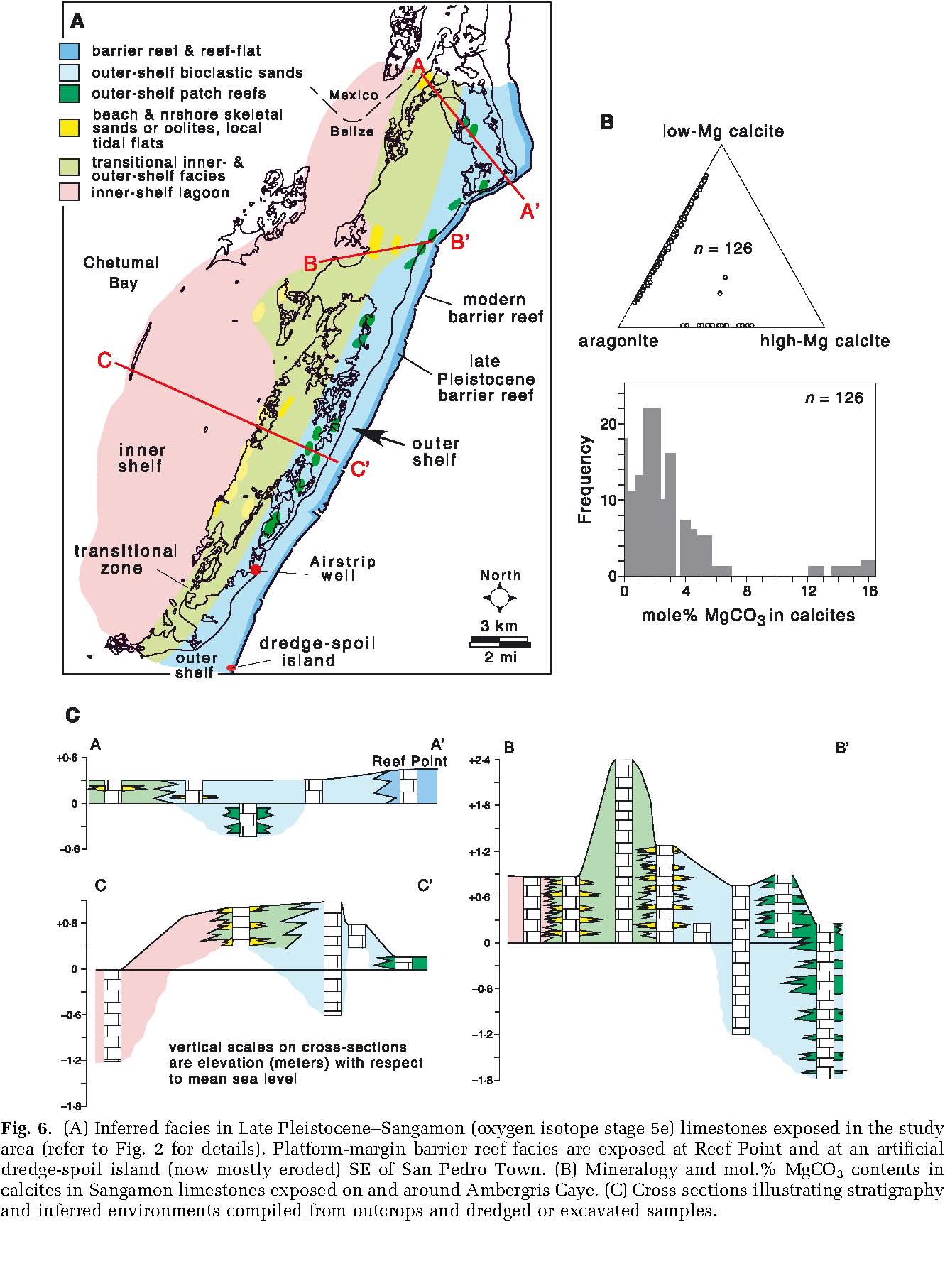
Fig. 6. (A) Inferred facies in Late Pleistocene–Sangamon (oxygen isotope stage 5e) limestones exposed in the study area (refer to Fig. 2 for details). Platform-margin barrier reef facies are exposed at Reef Point and at an artificial dredge-spoil island (now mostly eroded) SE of San Pedro Town. (B) Mineralogy and mol.% MgCO3 contents in calcites in Sangamon limestones exposed on and around Ambergris Caye. (C) Cross sections illustrating stratigraphy and inferred environments compiled from outcrops and dredged or excavated samples.
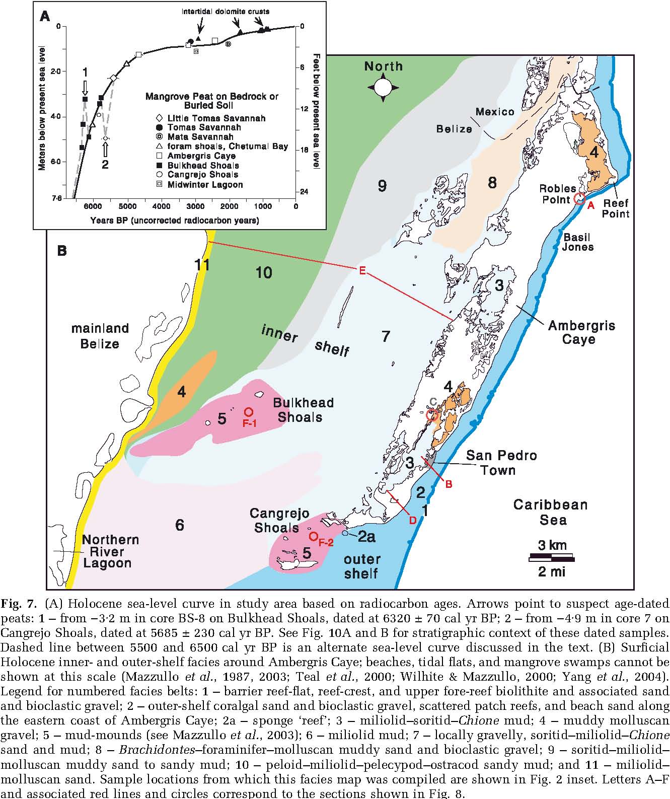
Fig. 7. (A) Holocene sea-level curve in study area based on radiocarbon ages. Arrows point to suspect age-dated peats: 1 – from )3Æ2 m in core BS-8 on Bulkhead Shoals, dated at 6320 ± 70 cal yr BP; 2 – from )4Æ9 min core7on Cangrejo Shoals, dated at 5685 ± 230 cal yr BP. See Fig. 10A and B for stratigraphic context of these dated samples. Dashed line between 5500 and 6500 cal yr BP is an alternate sea-level curve discussed in the text. (B) Surficial Holocene inner-and outer-shelf facies around Ambergris Caye; beaches, tidal flats, and mangrove swamps cannot be shown at this scale (Mazzullo et al., 1987, 2003; Teal et al., 2000; Wilhite & Mazzullo, 2000; Yang et al., 2004). Legend for numbered facies belts: 1 – barrier reef-flat, reef-crest, and upper fore-reef biolithite and associated sand and bioclastic gravel; 2 – outer-shelf coralgal sand and bioclastic gravel, scattered patch reefs, and beach sand along the eastern coast of Ambergris Caye; 2a – sponge ‘reef’; 3 – miliolid–soritid–Chione mud; 4 – muddy molluscan gravel; 5 – mud-mounds (see Mazzullo et al., 2003); 6 – miliolid mud; 7 – locally gravelly, soritid–miliolid–Chione sand and mud; 8 – Brachidontes–foraminifer–molluscan muddy sand and bioclastic gravel; 9 – soritid–miliolid– molluscan muddy sand to sandy mud; 10 – peloid–miliolid–pelecypod–ostracod sandy mud; and 11 – miliolid– molluscan sand. Sample locations from which this facies map was compiled are shown in Fig. 2 inset. Letters A–F and associated red lines and circles correspond to the sections shown in Fig. 8.
calcite crystals, syntaxial low-Mg calcite over-
Holocene reef-rimmed platform facies
growths on echinoid fragments, calcitization of skeletal aragonite and rare marine aragonite Surficial Holocene facies are shown in Fig. 7B cement, and partial replacement of some pelecy-and their characteristics are summarized in pod fragments by microcrystalline quartz. Table 2. The following section discusses only the most salient aspects of Holocene deposition that are relevant to the evolution of the northern Belize platform. Holocene marine carbonate sedimentation began ca 6500 cal yr BP based mainly on radiocarbon dates of buried mangrove peats (Fig. 7A) that directly overlie either Sangamon limestone or buried soil atop this limestone (Fig. 8).
Outer-shelf facies
The outer-shelf seawards of Ambergris Caye is narrow, and maximum water depth is 3 m. The barrier reef (facies 1) has not been the focus of previous sedimentologic studies (e.g. Mazzullo et al., 1992; Burke et al., 1998), and relative to the barrier in central and southern Belize it has received little attention (Miller & MacIntyre, 1977; James & Ginsburg, 1979; Burke, 1982; Perkins & Carr, 1985). Coralgal sand and gravelly sand (facies 2) overlie limestone bedrock on the outer shelf, and sediments coarsen to dominantly sandy, coral-fragment gravel towards the barrier reef. Sediments are generally thin (0Æ5 m), and commonly thicken landwards (Fig. 8A, B and D). This thickness trend reflects bedrock topography and dominant on-platform sediment transport caused by prevailing onshore, north-east trade winds. M. annularis-dominated patch reefs included within facies 2 are present locally, especially north of the latitude of San Pedro Town. They attain a maximum thickness of 2Æ4 m (Mazzullo et al., 1992; Burke et al., 1998). An area that contains relatively abundant loggerhead (Ircinia campana) and other sponges is present at the southern tip of Ambergris Caye (Fig. 7B). Associated biota include various non-framebuilding corals, ramose red and green algae, and thick-shelled gastropods (facies 2a: Table 2). Similar spongal deposits were not identified in exposed Pleistocene rocks.
At Robles Point and just north of Basil Jones (localities shown in Fig. 7B), and other localities along the eastern coast of northern Ambergris Caye, coralgal beach sands comprising storm washover, landward-dipping berm and seaward-dipping shoreface sub-facies are thin (1–2 m) where bedrock is close to the surface. A prominent 4 m high ridge comprising boulder-size coral– gastropod rubble overlying gravelly coralgal beach sand is present at Robles Point (Fig. 8A). These storm deposits, which had been modified and/or added to during Hurricanes Mitch and Keith in 1998 and 2000, respectively, trend northeastward along the shore nearly to Reef Point, where they thin out.
Bedrock is considerably deeper along the seaward coast of Ambergris Caye south of Basil Jones, and accordingly, thickness of coralgal beach sands and component sub-facies is greater – usually 4– 4Æ5 m (Fig. 8B and D). Locally, beach sands are muddy and relatively organic-rich where they are, or recently were, present in heavily Thalassiaand/or mangrove-colonized areas. Beach accretion is evident at several places along the seaward coast of Ambergris Caye. Radiocarbon dating of buried, unaltered Strombus gigas shells in northern San Pedro Town, for example, indicates accretionary deposition of 1Æ2 m of sand and ca 30 m of corresponding shoreline advance in the last 750 years (Fig. 8B, inset 1). At several localities south of San Pedro Town, as much as 40 m of shoreline advance in the last ca 500–750 years is indicated by the presence of Maya Late Classic conch middens that originally accumulated along a beach but which now are 40 m behind the modern beach (Fig. 8B, inset 2). Depending on location, beach sands either pinch-out against exposed limestone on the caye or they pass landwards variously into organic-rich swamp deposits of red mangrove (Rhizophora mangle) peat and/or peaty carbonate mud, or intra-island lagoonal facies 3 and 4 (Figs 7B, 8A and B), described below.
Facies on Ambergris and other cayes
In addition to seaward-facing beach sands, a variety of other environments are present on Ambergris and surrounding cayes, but they are not shown in Fig. 7B because of the limited scale. Intra-caye lagoonal deposits, for example, include mangrove swamp peats and/or dominantly foraminiferal (miliolids and soritids)–Chione (pelecypod) sandy and slightly gravelly mud (facies 3) and muddy mollusc gravel (facies 4). Such sediments usually average 1Æ2 m in thickness. Sea-marginal flats adjoining intra-caye lagoons, including tidal flats, are present locally. Sediments are typically are £1 m thick, component particles are dominated by molluscs and soritid foraminifers, and textures include some mud, mainly slightly gravelly and sandy mud and some muddy and slightly gravelly sand; all such sediments are derived from adjoining shallow lagoons (Fig. 8C). Microbial laminites produced by Scytonema or Schizothrix, desiccation cracks, flat-pebble mud clasts, root holes, and fenestrae are common in the upper parts of many such deposits, which locally contain abundant syndepositional dolomite (Mazzullo et al., 1987; Gregg et al., 1992; Mazzullo, 2000). Narrow beaches composed dom
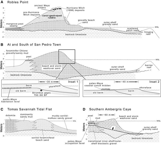
Fig. 8. Holocene facies; vertical scale exaggerated. (A) Coarse-grained offshore and beach deposits at Robles Point. Maximum 4 m-high ridge along shore capped by storm rubble. The barrier reef becomes a fringing reef here. Note palaeo-Maya artifacts. (B) Typical offshore and thick beach deposits at and south of the latitude of San Pedro Town. Inset 1 illustrates beach accretion and progradation in the last 750 years, concurrent with palaeo-Maya habitation, in northern San Pedro Town. Youngest beach sediments are 1Æ2 m thick. Inset 2 illustrates beach accretion associated with Maya Late Classic conch middens that originally accumulated along an older beach at a locality south of San Pedro Town. (C) Dolomitized tidal flat deposits adjoining foraminiferal sand beach and intra-island gravelly bioclastic lagoonal sediments. (D) Deposition of earliest Holocene, transitional outer-shelf–inner-shelf deposits on southern Ambergris Caye was terminated, at the horizon indicated by the arrow, by accretion of beach ridge ca 500– 750 years ago, resulting in shallowing-upward deposition of swamp peat deposits behind the beach. (E) Facies transect in inner-shelf, from back-side of Ambergris Caye to the Belize mainland. (F-1 and F-2) Carbonate sediments and associated deposits at the Bulkhead and Cangrejo Shoals mud mounds.
inantly of soritid foraminiferal sand are present shelf and outer-shelf biota (Table 2), that is locally along the margins of flats adjoining shal-capped by Rhizophora mangrove peat (Fig. 8D). low lagoons. Local beaches along the back side of This transitional facies tract, which is not present Ambergris Caye (Fig. 8E) are composed of £1m in surficial Holocene deposits, existed until of coarse-grained mollusc-and soritid foraminif-deposition of beach sand along the seaward coast er-dominated sandy bioclastic gravel. of southern Ambergris Caye isolated the inner-
Buried Holocene sediments in swampy areas on and outer-shelf areas about 500–1000 years ago the southern part of interior Ambergris Caye to (Dunn & Mazzullo, 1993). the immediate lee of the outer-shelf beach ridge typically are 2Æ0–2Æ4 m thick. They comprise a Inner-shelf facies shallowing-upward section of very coarse, mol-North-east-trending soritid foraminifer sand lusc-dominated skeletal gravel, with mixed inner-shoals (water depth 0–1 m) and adjoining deeper
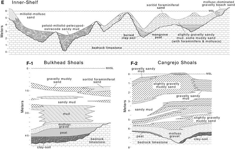
Fig. 8. Continued
water (maximum 1Æ8 m) areas of organic-rich, soritid–miliolid–molluscan sandy/gravelly mud and gravelly sandy mud are present behind Ambergris Caye in the eastern part of the inner shelf (Fig. 8E). These sediments (facies 7: Fig. 7B) variously overlie limestone bedrock, buried clay-soil (of post-Sangamon but pre-6500 cal yr BP age: Mazzullo et al., 2003), and/or Holocene mangrove peat. Maximum 14C ages of underlying mangrove peats are 6000 cal yr BP in the south and 5000 cal yr BP in the north (Wilhite & Mazzullo, 2000), and reflect northward marine transgression during the Holocene. As sea level reached close to the present stand a few thousand years ago (Fig. 7A), Holocene carbonate facies mainly have prograded to the south–south-west under the influence of dominant north-east trade winds and northers (Yang et al., 2004). Thickness of carbonate sediments varies from a few centimetres on bedrock highs to a maximum of ca 3m elsewhere. The foraminiferal shoal area passes north-east into water 1Æ2–1Æ8 m deep, where bedrock is locally mantled by only a thin veneer (a few centimetres) of Brachidontes–foraminiferan– molluscan muddy sand and bioclastic gravel (facies 8). Sediments pass progressively westwards within the inner shelf (Fig. 8E) from foraminiferal–molluscan muddy sand and sandy mud (facies 9: ca 0Æ6 m thick), to relatively deep-water (maximum depth 4Æ5 m) peloid–miliolid–pelecypod–ostracod mud and sandy mud (facies 10: 0– 2Æ4 m thick). Narrow beach sands locally are present along the mainland coast and comprise fine-grained, miliolid foraminifer and mollusc-dominated sand (facies 11: maximum 1Æ2m thick). Towards the south, inner-shelf facies are generally < 1 m of miliolid mud (facies 6) deposited in water depths of 6Æ0–7Æ6m.
Mud-mound facies
The lithology, biota and stratigraphic architecture of surficial (facies 5) and buried Holocene sediments comprising the Cangrejo and Bulkhead Shoals mud mounds were recently described by Teal et al. (2000), Mazzullo et al. (2003) and Yang et al. (2004). These mud mounds encompass areas of 20 and 35 km2, respectively, along the outer-shelf to inner-shelf transition (Cangrejo) and within the inner-shelf (Bulkhead). Buried clay soils of post-Sangamon but pre-6500 cal yr BP age locally overlie deeply submerged Pleistocene limestone in these areas, and in turn, they are overlain locally by Holocene mangrove peat (Fig. 8F-1 and F-2). Overlying carbonate sediments on the mud mounds are believed to be mainly storm deposits (Mazzullo et al., 2003).
They are organic-rich, mud-dominated, and contain relatively abundant syndepositional dolomite (Teal et al., 2000; Dimmick-Wells, 2002). Maximum thickness of Holocene deposits at Cangrejo and Bulkhead mud mounds is 7Æ6 and 4Æ5 m, respectively. Approximately 1 m or less of coarse-grained, muddy molluscan gravel (facies 4) atop bedrock is present to the immediate west of Bulkhead Shoals, where water depth is 2 m (Fig. 7B).
DISCUSSION
Late Pliocene-to-Holocene facies architecture
Samples from the Airstrip well are critical in that they link subsurface and outcrop sections and allow extension of the history of carbonate platform evolution in northern Belize into the Late Pliocene. In contrast, previous studies of platform development in central and southern Belize focused primarily on seismic study of the Late Pleistocene and Holocene deposits (Choi, 1981; Choi & Ginsburg, 1982; Choi & Holmes, 1982; Westphall, 1986; Esker et al., 1998; Ferro et al., 1999). Based on depositional environments inferred from the present study, the northern shelf changed abruptly from a shallowing-upward ramp during the Late Pliocene to a coral reef-rimmed platform in the Pleistocene and Holocene (Fig. 9A). A similar history is suggested farther to the south, at least locally, based on seismic study (Fig. 9C). This seismic section shows Pliocene strata in the upper part of the Belize Formation, including unconformity-capped upper Pliocene beds, correlative to the San Pablo and San Pedro Limestones in the Airstrip well. The inference is that these rocks represent a ramp rather than a rimmed platform. Purdy (1974a,b) reported shaly limestone in subsurface Miocene and Pliocene rocks in central to southern Belize that may be counterparts of the silty, shaly lime mudstone/ wackestone ramp deposits comprising the San Pablo Limestone in the Airstrip well (Fig. 4).
In the study area and perhaps elsewhere in Belize, the change from an unconformity-capped ramp to a rimmed platform may have been largely structurally controlled insofar as: (i) the seaward edge of the platform is fault-bounded (e.g. Purdy et al., 2003); and (ii) Late Neogene to Recent tectonic activity is documented in offshore Belize (Dillon & Vedder, 1973; Mazzullo & Bischoff, 1992; Lara, 1993; Ferro et al., 1999; Purdy et al., 2003). Among other possibilities, it is reasonable to suggest that movement along that fault system during the latest Pliocene and Early Pleistocene may have established a structural hinge along which Early Pleistocene barrier reef growth was focused and a rimmed platform initially developed (Fig. 9A). Once formed, this platform may have steepened over time as a result of a combination of processes such as: (i) karst accentuation of the platform-to-basin profile during sea-level lowstands (e.g. Purdy, 1974b); (ii) renewed reef growth along the platform edge during high-stands; and (iii) differential subsidence between the platform and adjoining basin. Such processes also are believed to have exerted control on the deposition of Holocene platform carbonates and the barrier reef in central and southern Belize (Choi, 1981; Choi & Ginsburg, 1982; Choi & Holmes, 1982; Westphall, 1986; Lara, 1993; Esker et al., 1998; Purdy, 1998; Ferro et al., 1999; Purdy et al., 2003). A shallow, flat-topped platform behind the barrier reef in the study area probably was maintained because of relatively low magnitudes of accommodation-space increase during highstands as are typical of icehouse states (Read et al., 1995), coupled with relatively low rates of platform subsidence. Yet, rates of subsidence were substantially high enough that platform and platform-marginal reef growth during the Pleistocene and Holocene mainly were aggradational, with only a minor component of basin-ward progradation (Fig. 9A). Aggradation is also suggested locally in central Belize (e.g. Fig. 9C), but farther south, progradation occurred instead (Esker et al., 1998; Ferro et al., 1999). Pleistocene and Early Holocene siliciclastics are present in central to southern Belize, where subsidence rates were higher than to the north (Gischler & Hudson, 2004). Whether the ‘shingled’ model of platform-margin accretion suggested by James & Ginsburg (1979) for post-Sangamon highstand deposits (Fig. 9B) is also applicable in the present study area cannot be evaluated based on currently available data.
If one assumes a Late Pliocene duration of 1Æ35 Myr (the average age of Pliocene N20 biozone of Bolli & Saunders, 1985) and the beginning of the Pleistocene at 1Æ65 Ma, then the sediment accumulation rate of the 150 m of ramp deposits in the Airstrip well might have been as much as 110 m Myr)1. Likewise, assuming Pleistocene rocks older than Sangamon age are present in this well and that the top-of-Sangamon unconformity formed ca 125 ka, then the duration of Pleistocene rimmed-platform deposition here was 1Æ5 Myr. If so, then the sediment accumulation
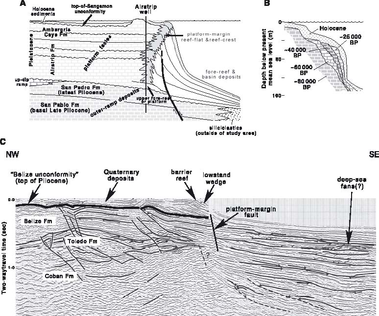
Fig. 9. (A) Depositional evolution in study area. The platform section in the Airstrip well (Fig. 4) includes inferred proximal to distal outer-shelf and barrier reef-flat deposits, whereas limestone exposures include both outer-and inner-shelf deposits, depending on location. Renewed faulting in the latest Pliocene to Early Pleistocene created a structurally defined platform margin along which Pleistocene barrier-reef growth was focused. Miocene and younger distal fore-platform deposits to the south–south-east of the study area include siliciclastics (Case et al., 1984).
- (B)
- Shingled model of Belize platform-margin accretion in the last 80 000 years (after James & Ginsburg, 1979). Lithologic units denoted by time are those presumably deposited during sea-level highstands since the Sangamon.
- (C)
- Seismic section APE 84-08, which is the closest such data to the study area (see Fig. 1). Section and interpretations from Purdy et al. (2003) after Ferro et al. (1999). Note the slightly progradational Quaternary reef-rimmed platform margins, and absence of obvious reef-rimmed platforms in subjacent Pliocene strata in the upper part of the Belize Formation.
rate was about 87 m Myr)1, which is an order of Caribbean and elsewhere (Schlager, 1992, 1999), magnitude less than that of the upper Pliocene which suggests the relatively limited amount of ramp deposits. Platform sedimentation rates, subsidence and accommodation space increase however, typically are greater than those on that occurred in the study area since the Late deeper-water ramps (Schlager, 1992). The seem-Pliocene. ingly anomalous Pleistocene rate may suggest that not all of the Pleistocene is in fact present in the
Pleistocene cyclicity
Airstrip well, and/or that the total amount of time represented by unconformities here is substantial. The sea-level drop and top-of-Pliocene uncon-Regardless, these rates are less than the range of formity inferred in the Airstrip well (Figs 3 and 4) short-term (102–105 years) rates reported in the are also recognized in central and southern Belize (Choi & Ginsburg, 1982; Choi & Holmes, 1982; Esker et al., 1998; Ferro et al., 1999; Purdy et al., 2003) and elsewhere in the world (e.g. Haq et al., 1988) suggesting that they record a glacio-eustatic lowstand. Above the top-of-Pliocene unconformity, the Pleistocene section in the study area comprises four recognizable, relatively low-frequency cycles punctuated by unconformities, including the top-of-Sangamon unconformity (Figs 4 and 9A). These cycles, interpreted as depositional sequences, almost certainly are also of glacio-eustatic origin. Choi & Holmes (1982) and Ferro et al. (1999) likewise identified four and five unconformity-bounded seismic sequences in subsurface Pleistocene strata in southern and central Belize, respectively. In contrast, Esker et al. (1998) identified 11 such sequences in subsurface Pleistocene strata in southern Belize. Specific correlation of the sequences identified by these workers to those in the study area is not possible.
At least nine component higher-frequency, subtidal cycles are recognized in the Pleistocene section in the Airstrip well (Fig. 4), which probably include autocycles and eustatically forced cycles; such cycles and unconformities could not be resolved in the Pliocene beds. The cycles include: (i) those that shallow and fine upwards (1, 2, 6, 7 and 9) from coarse-grained, relatively coral-rich rocks (medial to distal outer-shelf) to fine-grained rocks (somewhat protected, near-shore outer-shelf); (2) cycle 5, which shallows upwards from coral-rich to carbonate sand-rich; and (3) those punctuated by unconformities (3, 4 and 8). The study area was far from the mainland during the Pleistocene. Hence, these cycles probably represent local shallowing-upward deposition of scattered patch reef-cored or carbonate sand-cored islands in an outer-shelf setting rather than prograding coastal deposits. Reduction in thickness of cycles 1 to 9 reflects a decreasing rate of accommodation space as the location of the Airstrip well shallowed in the Early Pleistocene (Fig. 9A).
Holocene sedimentation and tectonics
Some movement along faults that involve Sangamon-age limestone appears to have affected Holocene marine deposition in the study area as it has elsewhere in offshore Belize (Purdy et al., 2003). Evidence for such includes the two buried, radiocarbon-dated peats directly overlying Pleistocene limestone at localities BS-8 at Bulkhead Shoals and 7 at Cangrejo Shoals (locations denoted by arrows in Fig. 7A). These dates are anomalous relative to their depth in that at 3Æ2m and 4Æ9 m below MSL, the peats should be younger than their determined ages of 6320 ± 70 and 5685 ± 230 cal yr BP, respectively. Assuming these ages are accurate, they could be interpreted as suggesting rapidly fluctuating sea level from between ca 6500 to 5500 cal yr BP (dashed line in Fig. 7A). Although Late Pleistocene to Holocene centennial-scale fluctuations have been suggested elsewhere in the world (e.g. Locker et al., 1996; Neumann & Hearty, 1996; Baker & Haworth, 2000a,b), they have not been identified on other Belize sea-level curves (e.g. Ferro et al., 1999; Gischler & Hudson, 2004). An alternative explanation is that there has been some Holocene, post-depositional movement along faults at these localities, with cores BS-8 and 7 being on the up-thrown sides of normal faults. If so, then the maximum amount of throw along the faults is as much as 2 m (Fig. 10A and B). It is possible that these two areas are located along a single fault system that trends north-west– south-east across southern Chetumal Bay and which may be the extension of a fault offshore of southern Ambergris Caye (Fig. 10C). Periodic discharge of meteoric fluid along a postulated arcuate fault that trends northeast from Black-adore Caye to southern Deer Caye in Chetumal Bay (Fig. 10C) has resulted in nearly pervasive alteration to low-Mg calcite of Holocene sediments of original high-Mg calcite composition (Mazzullo & Bischoff, 1992). Whether there has been movement along that fault during the Holocene, however, is not known.
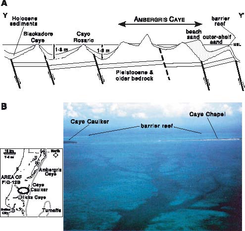
The bedrock topography of much of Ambergris Caye south of the latitude of Basil Jones, and in surrounding offshore areas, is a series of northeast-trending ridges and swales (Figs 10D and 11A). The highest linear ridge on Ambergris Caye is ca 1Æ8 m above sea level. Exposed bedrock to the north is more or less uniformly high, and distinct ridges and swales are not readily obvious. The easternmost linear bedrock swale along the seaward coast of Ambergris Caye (Fig. 8B and D) is a maximum of 4Æ3 m below MSL. It extends nearly uninterruptedly in a south-west direction, and is the terminus of a west-sloping topographic surface on the Sangamon limestone. The eastern side of this surface is a known fault that defines a raised rim (sensu Purdy, 1974a,b) on which the Holocene barrier reef has developed (Fig. 11B). A ridge of bedrock limestone close to and/or exposed above sea level is present to the immediate
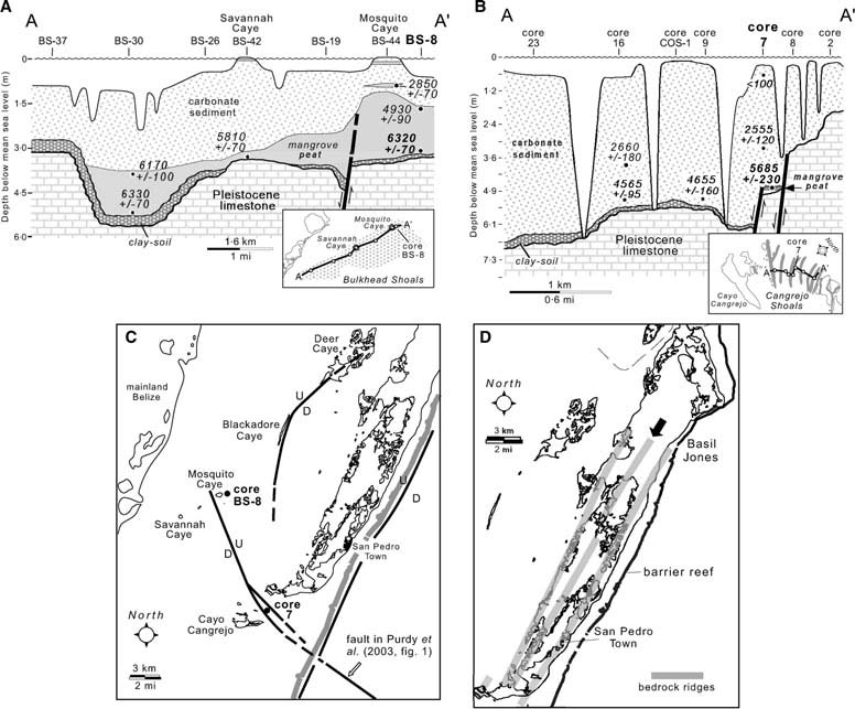
Fig. 10. (A, B) Stratigraphy, radiometric dates, and inferred Holocene faulting around core localities BS-8 on Bulkhead Shoals and 7 on Cangrejo Shoals (after Mazzullo et al., 2003). (C) Some inferred post-Sangamon faults (bold black lines) in study area. The southernmost fault may be the landward extension of an offshore fault shown in Purdy et al. (2003). See fault along seaward side of Ambergris Caye in Fig. 12A. (D) Prominent bedrock ridges on Ambergris Caye, the highest of which is denoted by an arrow. Except for north of Basil Jones and locally along the central-eastern part of the caye, the easternmost ridge is mostly below sea level and buried beneath Holocene sediment.
west of the swale (Fig. 10D), and is separated from it by a low scarp. Similar topographic configurations are present elsewhere in the study area (Fig. 11A). The uniform westward slope of the bedrock surface between such ridges, the presence of a fault along the seaward side of the barrier reef (Fig. 9A and C), and the existence of inferred faults in Chetumal Bay (Fig. 10C) suggest that the bedrock foundation of the study area comprises slightly tilted fault blocks (Fig. 12A). Such an interpretation is consistent with the transtensional rifted-margin setting of the area (e.g. Dillon & Vedder, 1973; Bishop, 1980; Lara, 1993), and is similar to the structural fabric farther south in Belize (e.g. fig. 1 in Purdy et al., 2003). Purdy (1974a,b) rightfully considered that the top-of-Pleistocene topography in northern Belize resulted largely from post-Sangamon karsting, but he also recognized the possible structural origin of bedrock ridges on Ambergris Caye. Structure, be it related to faults and/or fractures, has clearly influenced karsting and subsequent Holocene deposition in the study area by controlling the locations of the Pleistocene and Holocene barrier reefs, the location and thickness of inner-shelf deposits (Fig. 8E), and the distribution of coralgal beach and marine sands on the outer shelf (Fig. 8A, B and D).
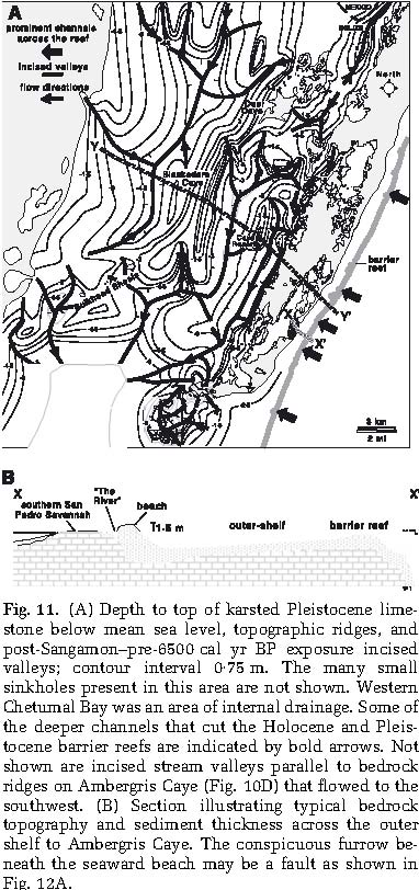
Fig. 11. (A) Depth to top of karsted Pleistocene limestone below mean sea level, topographic ridges, and post-Sangamon–pre-6500 cal yr BP exposure incised valleys; contour interval 0Æ75 m. The many small sinkholes present in this area are not shown. Western Chetumal Bay was an area of internal drainage. Some of the deeper channels that cut the Holocene and Pleistocene barrier reefs are indicated by bold arrows. Not shown are incised stream valleys parallel to bedrock ridges on Ambergris Caye (Fig. 10D) that flowed to the southwest. (B) Section illustrating typical bedrock topography and sediment thickness across the outer shelf to Ambergris Caye. The conspicuous furrow beneath the seaward beach may be a fault as shown in Fig. 12A.
Pleistocene to Holocene highstand–lowstand facies and incised valleys
Alternating periods of highstand carbonate and lowstand valley incisement and associated fluvial siliciclastic deposition are suggested for subsurface upper Pleistocene to Holocene deposits in central and southern Belize (Choi, 1981; Choi & Ginsburg, 1982; Choi & Holmes, 1982; Esker et al., 1998; Ferro et al., 1999). Despite a similar history of sea-level fluctuations, there are essentially no siliciclastics in upper Pliocene and Pleistocene rocks (Figs 4 and 5 and Table 3) or in Holocene sediments (Table 2) in the study area. Minor detrital quartz and biotite in Pliocene limestone in the Airstrip well (Figs 3 and 4), and <1% quartz silt in Holocene sediments (Teal et al., 2000; Wilhite, 2000; Dimmick-Wells, 2002), represent the only siliciclastic influx into the area. The closest siliciclastics are present along the mainland coast to the southwest, in and around Midwinter Lagoon and Northern River Lagoon (Fig. 1) (High, 1975; Burke et al., 1992; Lowe, 1995; Lowe & Mazzullo, 1995; Purdy et al., 2003). The paucity of siliciclastics in the study area reflects: (i) distance from the Maya Mountains source; and (ii) since at least the Pliocene, regional drainage from the mountains has been mostly to the east–south-east, rather than towards the study area. This is probably a result of progressive subsidence and tilting of the Belize platform to the south since at least the Pleistocene
(e.g. Ferro et al., 1999). The lateral change from carbonate deposition to mixed carbonate-siliciclastic deposition is a common pattern in the stratigraphic record (e.g. Doyle & Roberts, 1988; Budd & Harris, 1990; and Lomando & Harris, 1991). Because of the absence of siliciclastics, the stratigraphic architecture in northern Belize instead comprises superimposed couplets of high-stand carbonates and lowstand unconformities.
In addition to dolines, caves and caverns, limestone karsting in the study area resulted in conspicuous incised valleys along the top-of-Sangamon unconformity (Fig. 11A). Similar valleys may be present along older unconformities here, but they are not readily recognizable. Structural control on valley occurrence, which is also indicated to the south (Esker et al., 1998; Ferro et al., 1999), is suggested by the parallelism of most valleys and structural ridges (Figs 8B, D and 11). Moreover, whereas the drainage pattern in most of Chetumal Bay is somewhat dendritic, there is a strong overprint of rectilinear drainage, particularly on and around Ambergris Caye. Such a pattern reflects the dominant north-east and approximately east–west structural grain of the area. Whereas valley-fill deposits to the south are believed to be fluvial to estuarine siliciclastics overlain transgressively by lagoonal siliciclastics and carbonates (Esker et al., 1998; Ferro et al., 1999; and earlier studies cited therein), such is not the case in northern Belize. Instead, incised valleys are partly filled variously by clay-soil, mangrove peat and marine carbonate sediments. It is possible that siliciciclastics may have been present during the latest Pleistocene and Early Holocene, and they either completely by-passed
Fig. 12. (A) Schematic section illustrating postulated karst-modified bedrock structure and relationship to Holocene sediments in the study area. (B) Aerial photo of a valley incised into bedrock limestone just south of the study area; view is to east, with the Holocene barrier reef in the background. Note that the pattern of tributaries entering the trunk stream suggests that flow was from east-to-west rather
than in a seaward direction across the platform.
the platform during lowstand or were transported westwards during Holocene transgression. Such an interpretation might be tenable only if at least some siliciclastics had been encountered in any of the hundreds of samples collected (Fig. 2) over the last 25 years. Moreover, most of the valleys do not flow into the study area from the mainland. Rather, most valley heads are rooted in limestone bedrock, including those streams that flowed westward from the topographic high that now is Ambergris Caye (Fig. 11A); this terrain does not include any siliciclastics. A notable example of westward rather than eastward stream flow across the exposed Sangamon carbonate platform, denoted by tributary–junction angles, is a large incised valley immediately south of the study area (Fig. 12B). Westward stream flow generally followed the slope of underlying tilted fault blocks (Fig. 12A).
The incised valleys in the study area dominantly have U-shaped cross-sectional profiles (Fig. 11A). In contrast, incised valleys in central and southern Belize have V-or U-shaped profiles, which Ferro et al. (1999) ascribed to erosion by streams transporting dominantly relatively coarse-sediment bed-loads and suspended loads, respectively. Because of the absence of siliciclastics, it is suggested that the valleys in the study area formed solely as a result of dissolution during post-Sangamon lowstand. Purdy (1974a,b) recognized such dissolution-carved, U-shaped valleys in central Belize (e.g. English Caye Channel: Fig. 1). Depth of valley incisement, valley gradients, and topographic relief are considerably less in the study area than in subsurface central to southern Belize. These parameters probably reflect the development of only shallow doline-karst in northern Belize relative to more intense karstification to the south (Purdy, 1974a,b; Purdy et al., 2003). Notwithstanding caverns, <20 m of relief is indicated by the sum of the maximum elevation of outcrops on Ambergris Caye and maximum depth below sea level of top-of-Sangamon bedrock. In contrast, subsurface topographic relief to the south is as much as 80 m (Ferro et al., 1999).
Diagenesis of Pliocene and Pleistocene rocks
Marine diagenesis in the Pliocene and Pleistocene limestones in the study area included micritization of grains and the precipitation of some aragonite and high-Mg calcite cements in reef deposits in the Pleistocene rocks. Assuming a mean Belize shelf sea water d18O value of ca 1Æ4& as today (Teal et al., 2000), the positive d18O values of the Pliocene dolomite in the Airstrip well (mean of ca 3&: Fig. 5B) could suggest that dolomitization began syndepositionally in marine pore fluids of near-normal composition. Early dolomitization of relatively deep-water, muddy, organic-rich deposits is common in Tertiary and Holocene sediments (Mazzullo, 2000). The general trend of increasing dolomite d13C values with depth (Fig. 5B) may suggest increasing involvement of bacterial methanogenesis during dolomitization. Such reactions are common in many organic-rich sediments as pore-water chemistry evolves from sulfate reduction into the methanogenic realm (Mazzullo, 2000; Teal et al., 2000). The dolomite stable isotope data alternatively could imply that dolomitization began syndepositionally and then continued in the marine shallow-burial environment, or that conversely it was initiated solely within the latter environment. In either case, the dolomite was precipitated from circulating marine pore fluids of near-normal composition based on dolomite d18O values. Increased dolomite stoichiometry roughly tracks the presence of calcites with relatively high residual Mg content (Fig. 5). It is possible that the main phase of dolomitization occurred during the Pleistocene mainly in the marine-burial environment and subsequent to end-of-Pliocene subaerial exposure.
Dolomite d18O and d13C values increase slightly (up to +3Æ8&) and are considerably lighter (mean of ca +1&), respectively, above the middle of the San Pedro Member (at ca 165 m depth) in the Airstrip well (Fig. 5A). Dolomite formed interstitially in circulating sea water suggests that d18O enrichment may record global sea water cooling and the onset of glaciation during the Late Pliocene to Early Pleistocene (e.g. Williams, 1988). It is also possible, but not resolvable based on the current sample set, that the stable isotope compositional field of the dolomite above 165 m depth defines a population that is distinct in terms of timing from the dolomite below that depth. The short-term fluctuations of dolomite d13C values up-section in the well, but below 165 m, are matched by very subtle but opposite trends in d18O values (Fig. 5B). Such data may suggest slight temporal fluctuation of pore-water chemistry during dolomitization, which mostly affected d13C values, related possibly to variations in the extent and type of microbial activity in the sediments (e.g., Teal et al., 2000). Alternatively, these d13C trends may reflect variations in the relative contribution of different sources of carbon during dolomitization.
Subaerial diagenesis of the Pliocene and Pleistocene limestones attending multiple periods of exposure to meteoric fluids resulted in: (i) dissolution of aragonitic particles; (ii) variable degree of stabilization of high-Mg calcite to low-Mg calcite; (iii) the generation of mostly light whole-rock d18O and d13C values; and (iv) in the Pleistocene limestone, the local precipitation of calcite whisker crystals and meniscus cements. In the Pliocene rocks there is some higher-Mg calcite than in overlying subsurface Pleistocene rocks (4– 9 mol.% versus maximum of 7 mol.%; Fig. 5A). Moreover, there is minor residual aragonite in the Pliocene rocks, but none in the Pleistocene except for at the top of the section (Fig. 4). Although slight, these mineralogical and geochemical differences may reflect somewhat less extensive meteoric alteration of dominantly micritic and otherwise fine-grained, lower-permeability Pliocene rocks than in the coarser-grained Pleistocene limestones. In contrast, there is more higher-calcite (with as much as 16 mol.% MgCO3)in exposed Sangamon-age limestones than in subsurface Pleistocene rocks, and these exposed limestones contain some aragonite (Figs 5A and 6B). Obviously, only one episode of nearly 110 000 years of meteoric exposure was not sufficient to diagenetically alter these rocks as much as subsurface strata, whose relatively greater degree of alteration probably reflects multiple episodes of sea-level lowstand and subaerial exposure (Fig. 4). Within the subsurface rocks there is a relatively long-term trend of decreasing whole-rock d18Oand d13C values upwards in the section, at least from above ca 165 m depth if not throughout the entire section (Fig. 5A). Mean whole-rock d18O and d13C values in the Pliocene rocks of 0& and +1&, respectively, may partly reflect a mixture of original components in the limestone and isotopically more positive dolomite stable isotope values. There is no petrographic evidence to support or deny a contention that whole-rock stable isotope values in these rocks might indicate diagenetic alteration in the marine-burial environment (e.g. Melim et al., 1995, 2001a,b). The availability of only cuttings samples, however, limits the detail to which diagenesis can be evaluated. The observed d18O trend is counter to that compiled from deep-sea records, and there is no such trend recognized in d13Cdata (e.g. Williams et al., 1988). Hence, the whole-rock stable isotope data in the Airstrip well are interpreted to reflect: (i) the presence of more extensively altered (Pleistocene) rocks upwards in the section; and (ii) the overall diagenetic significance of the top-of-Sangamon unconformity. The shorter-term d13C signal within the data parallel essentially invariant d18O values, and with the exception of the most negative d13C values immediately beneath the top-of-Sangamon unconformity, they do not coincide with the stratigraphic locations of any of the other unconformities in the section (Fig. 5A). The significance of these short-term signals is not immediately apparent.
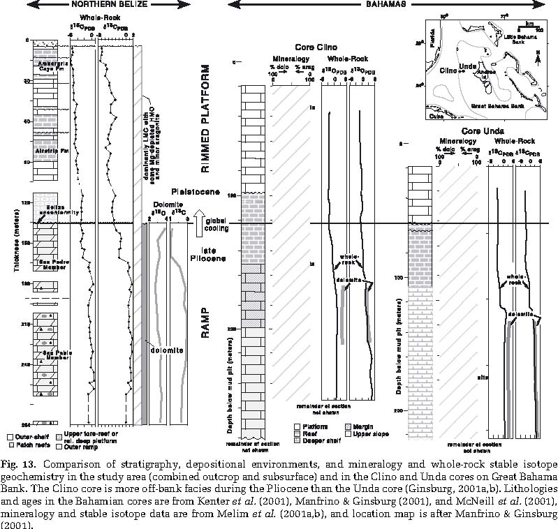
The celestite in the Pliocene San Pablo Limestone may have formed in the shallow-burial diagenetic environment, after dolomitization, with Sr supplied from up-dip dissolution of aragonite, and sulfate derived from circulating pore water and/or an up-dip source of evaporites
(e.g. Scholle et al., 1990; Taberner et al., 2002; Hanor, 2004). Gypsum is present in Cretaceous and Tertiary strata exposed on the Belize mainland (King et al., 2004).
COMPARISON WITH BAHAMIAN PLATFORM EVOLUTION AND DIAGENESIS
Despite the great distance between the two areas, upper Pliocene to Pleistocene depositional facies and sedimentological evolution in northern offshore Belize are very similar in several respects to those parameters in two deep cores (Unda and Clino, Fig. 13) taken on the western Great Bahama Bank (Lidz & McNeill, 1998; Westphal, 1998; Westphal et al., 1999; Ginsburg, 2001a; Kenter et al., 2001; Manfrino & Ginsburg, 2001; McNeill et al., 2001). Carbonate deposition dominated in both areas, and upper Pliocene ramps similarly shallowed upwards and were replaced by rimmed
Fig. 13. Comparison of stratigraphy, depositional environments, and mineralogy and whole-rock stable isotope geochemistry in the study area (combined outcrop and subsurface) and in the Clino and Unda cores on Great Bahama Bank. The Clino core is more off-bank facies during the Pliocene than the Unda core (Ginsburg, 2001a,b). Lithologies and ages in the Bahamian cores are from Kenter et al. (2001), Manfrino & Ginsburg (2001), and McNeill et al. (2001), mineralogy and stable isotope data are from Melim et al. (2001a,b), and location map is after Manfrino & Ginsburg (2001).
platforms across the Pliocene–Pleistocene boundary. That boundary also is an unconformity in the up-dip Unda core. Such architectural change coincided with the onset of Northern Hemisphere glaciation during the Pliocene (Cronin & Dowsett, 1991; Raymo, 1994). Whether there was a causal relationship between these events cannot be determined. However, these areas experienced a similar history of decreasing accommodation into the Pleistocene concurrent with a change to successively lower-amplitude sea-level fluctuations (e.g. Beach & Ginsburg, 1980) as is common during icehouse times (Read et al., 1995). Encrusting and ramose red algae are abundant in Pliocene–Pleistocene boundary strata in both areas, which may reflect postulated relatively deeper-water upper Pliocene and earliest Pleistocene environments, and/or slight ocean cooling at this time. Whereas platform sedimentation in northern Belize was dominantly aggradational since the Pleistocene, it was mostly progradational on Great Bahama Bank with the exception of a period of aggradation during the middle to Late Pleistocene (McNeill et al., 2001). Pleistocene deposits similarly include glacio-eustatically forced cycles. Correlation of the 10 to 13 unconformity-bounded cycles in the Clino and Unda cores, respectively, to either the four unconformity-bounded cycles or nine component higher-frequency cycles in northern Belize (Fig. 4) is not possible because of lack of specific age assignments in the latter section. A notable difference between the two areas is that tectonism apparently has significantly influenced Pleistocene and Holocene sedimentation in Belize.
The similarity of diagenetic processes and products in the upper Pliocene and Pleistocene rocks in Belize and on Great Bahama Bank (in the latter area described by Kenter et al., 2001; Melim et al., 2001a,b; and Swart et al., 2001), is even more striking (Fig. 13). Evidence exists in both areas for marine-burial diagenesis (mainly involving dolomitization in Belize) and multiple periods of subaerial meteoric diagenesis (e.g. Melim et al., 1995, 2001b; Kenter et al., 2001). Such a motif is a first-order response to similar histories of largely glacio-eustatically controlled sea-level fluctuations. Trends of whole-rock d18Oand d13C values are almost identical in both areas, although the Belize samples are somewhat more depleted in d18O and particularly in d13C. The Bahamian Pliocene rocks contain considerably more aragonite than their Belize counterparts, particularly in the Clino core. Melim et al. (2001b) attributed aragonite preservation to diagenetic alteration mainly in the marine-burial environment, which corresponds to increasing stable isotope values relative to those in overlying Pleistocene rocks which instead were altered mainly by meteoric fluids. In the Belize samples, preservation of relatively high Mg contents in calcite and only minor aragonite in the Pliocene rocks instead is attributed to less extensive meteoric alteration of dominantly low-permeability micritic rocks. In contrast, diagenetic alteration was more extensive in the coarser-grained, presumably higher-permeability Pleistocene rocks. That Belize is located in an area of greater average annual rainfall than Great Bahama Bank may influence the relative extent of meteoric alteration in these areas, and may at least partly explain the slight differences in the d18O and d13C values of Pleistocene whole-rock samples.
Significant amounts of dolomite are present in both areas and only in Pliocene rocks. The mean d18O value of the Bahamian dolomite likewise is ca +3&, and it similarly is interpreted as having precipitated from circulating sea water of near-normal composition. Mean d13C values in both areas cluster around 2Æ5–3&. A similar dolomite origin may reflect the open-ocean facing setting of both areas, and their consequent exposure to normal-marine sea water. Dolomite abundance and its analogous timing of formation strengthen the contention that shallow-burial dolomitization via circulating marine pore fluids (e.g. Saller, 1984; Simms, 1984; Vahrenkamp & Swart, 1994; Whitaker et al., 1994) is a common process within carbonate platforms. Possible bacterial involvement in Bahamian dolomite formation was not addressed by Melim et al. (1995, 2001a,b) or others (e.g. Vahrenkamp & Swart, 1994; Whitaker et al., 1994). Both areas share the common presence of celestite in the Pliocene rocks (see Melim et al., 2001a,b). Despite the distance between Belize and the Bahamas, the similarities between the two areas in terms of platform evolution and diagenesis reflect fundamental control on these parameters by glacioeustasy, climate change and sea water chemistry during the Late Pliocene and Pleistocene.
CONCLUSIONS
The lithostratigraphy, depositional facies and architecture, diagenesis, and nature and extent of inferred sea-level fluctuations and tectonic controls on the deposition of upper Pliocene to Holocene carbonate deposits in northern offshore Belize are evaluated based on strata in the Airstrip well on Ambergris Caye, limestone exposed on and around the caye, and Holocene marine sediments. The basal part of the subsurface section in the Airstrip well includes ca 150 m of dolomitic, slightly silty and siliceous, fine-grained limestone of upper Pliocene age. These rocks are overlain unconformably by ca 133 m of dominantly coarse-grained, coralgal limestone of Pleistocene age. The youngest strata in the Airstrip well partly overlap with and are overlain by additional section of Pleistocene limestone that is exposed on and around Ambergris Caye. A sample of exposed limestone is radiometrically dated at 135 800 years and is assigned to oxygen isotope stage 5e (Sangamon interglacial).
Pliocene rocks in the Airstrip well comprise relatively deep-water ramp deposits that shallowed upwards and which are capped by an unconformity. Depositional architecture changed abruptly across the Pliocene–Pleistocene boundary to a progressively shallower reef-rimmed platform, which has persisted into the Holocene, coincident with the onset of northern Hemisphere glaciation. Similar depositional history and architecture are indicated farther south in Belize based on seismic data, and also along the western side of Great Bahama Bank. Pleistocene facies in the well and in outcrops include:
(i) platform-marginal, coralgal barrier-reef deposits composed of framebuilding corals such as A. palmata, A. cervicornis,and Agaricia spp. and associated with relatively abundant Homotrema and encrusting coralline algae; and to their lee; (ii) a wide outer-shelf tract of coralgal sand with scattered patch reefs, the latter dominated by M. annularis. with little to no Homotrema or coralline algae; (iii) a wide outer-shelf to inner-shelf transition zone that comprises nearshore coralgal and some oolitic sand, coarse skeletal beach sands fringing small islands and/or tidal flats, and locally, fine-grained foraminiferal sands; and (iv) a micritic, molluscan-dominated, inner-shelf lagoon. Four unconformity-bounded depositional sequences of probable glacio-eustatic origin are recognized in the Pleistocene section. Component higher-frequency, shallowing-upward cycles are of sub-tidal character, and probably include such forced cycles and autocycles. With the exception of oolites, the facies present in Pleistocene rocks are represented in Holocene deposits, which also include mud-mounds, inner-shelf foraminiferal sand shoals, and within the interior of Ambergris and surrounding cayes, Rhizophora mangrove swamps, shallow lagoons, and tidal and sea-marginal flats.
The initial development of a flat-topped, reef-rimmed platform during the Pleistocene was structurally controlled, and platform-to-basin topography was maintained and accentuated into the Holocene by barrier reef growth, lowstand karstification, differential platform-to-basin subsidence, and low magnitude of eustatic accommodation-space increases during highstands. Subsidence rate during Pleistocene and Holocene deposition was less than in central to southern Belize, but high enough that a dominantly aggradational style of platform accumulation developed. Syndepositional and post-depositional faulting locally affected Pleistocene and Holocene deposition. Unlike central and southern Belize, there was no siliciclastic influx during Pleistocene lowstands. The drainage pattern of incised valleys along the top-of-Sangamon unconformity was largely controlled by bedrock structure, and these channels are believed to have formed by karst dissolution.
Positive dolomite d18O and d13C values in Pliocene rocks suggest formation in the early post-depositional shallow-burial environment, in contact with circulating marine pore fluids of near-normal composition. Pore-water chemistry, however, was probably modified by bacterial methanogenesis. Recurrent subaerial exposure during lowstands resulted in more intense meteoric alteration of Pleistocene limestones than in the finer-grained Pliocene rocks. Such diagenesis is suggested by aragonite dissolution, variable degree of high-Mg calcite stabilization, up-section trends of more depleted whole-rock d18Oand d13C values, and locally, precipitation of meniscus and whisker-crystal calcite cements. The diagenetic, mineralogic, and stable isotopic attributes of the Pliocene and Pleistocene rocks in the study area are remarkably similar to those in the western Great Bahama Bank with which they share a common history of platform evolution, climate change and sea-level fluctuations, and similar ocean-water oxygen isotope chemistry.
ACKNOWLEDGEMENTS
This study was funded in part by a grant from the Petroleum Research Fund of the American Chemical Society, and I gratefully acknowledge the donors of ACS-PRF for this support. Additional funding was variously provided to students involved in this project over the years by the Geological Society of America, American Association of Petroleum Geologists, Kansas Geological Society, Kansas Geological Foundation, and SIPES; and to grants to me from Texaco and a number of other petroleum companies. Assisting in the field over the years were my colleagues Bill Bischoff, Collette Burke and Wan Yang, and former students Krysti Weed, Chellie Teal, Cynthia Burtnett, Brian Wilhite, Kimberly Dimmick-Wells, and Craig Bjork. I thank Barbara Lidz (USGS) for identification of foraminifers in the Airstrip well samples, Ken Rubin (University of Hawaii) for U–Th dates of Pleistocene corals, and Colin V. Murray-Wallace (University of Goolongong) for amino acid racemization data from Pleistocene gastropods. I very much appreciate the efforts of reviewers Chris Kendall and Brian Holland for their constructive comments on the original manuscript. I especially thank Isabel Montan˜ ez for her many constructive comments on the original manuscript.
Click here for information on Marco Gonzales Maya site.
Click here for information on the geology of Ambergris Caye.
Click here for information on the Holocene Sediments of the Belize Shelf.
REFERENCES
Baker, R.G.V. and Haworth, R.J. (2000a) Smooth or oscillating late Holocene sea-level curve? Evidence from cross-regional statistical regressions of fixed biological indicators. Mar. Geol., 163, 353–365.
Baker, R.G.V. and Haworth, R.J. (2000b) Smooth or oscillating late Holocene sea-level curve? Evidence from the palaeozoology of fixed biological indicators in east Australia and beyond. Mar. Geol., 163, 367–386.
Beach, D.K. and Ginsburg, R.N. (1980) Facies succession of Pliocene-Pleistocene carbonates, northwestern Great Bahama Bank. AAPG Bull., 64, 1634–1642.
Birdwell, B.W. (1992) The Distribution, Mineralogy, Geochemistry, and Petrography of Recent Dolomite, San Pedro Savannah, Ambergris Cay, Belize. MS thesis, Wichita State University, Wichita, KS, 134 pp.
Bishop, W.F. (1980) Petroleum geology of northern Central America. J. Petrol. Geol., 3, 3–59.
Bolli, H.M. and Saunders, J.B. (1985) Oligocene to Holocene low latitude planktic foraminifera. In: Plankton Stratigraphy (Eds H.M. Bolli, J.B. Saunders and K. Perch-Nielsen), pp. 155–262. Cambridge University Press, Cambridge, UK.
Budd, D.A. and Harris, P.M. (Compilers) (1990) Carbonate-Siliciclastic Mixtures. SEPM Reprint Ser., 14, 272.
Burke, R.B. (1982) Reconnaissance study of the geomorphology and benthic communities of the outer barrier reef platform, Belize. In: The Atlantic Barrier Reef Ecosystem at Carrie Bow Cay, Belize, I -Structure and Communities (Eds
K. Rutzler and I.G. MacIntyre), Smithsonian Contrib. Mar. Sci., 12, 509–526.
Burke, C.D., Mazzullo, S.J., Bischoff, W.D. and Dunn, R.K. (1992) Environmental setting of Holocene sabellariid worm reefs, northern Belize. Palaios, 7, 118–124.
Burke, C.D., McHenry, T.M., Bischoff, W.D. and Mazzullo, S.J. (1998) Coral diversity and mode of growth of lateral expansion patch reefs at Mexico Rock, northern Belize shelf, Central America. Carbonates Evaporites, 13, 32–42.
Case, J.E., Holcombe, T.L. and Martin, R.G. (1984) Map of geologic provinces in the Caribbean region. In: The Caribbean-South American Plate Boundary and Regional Tectonics (Eds W.E. Bonini, R.B. Hargraves and R. Shagam), Geol. Soc. Am. Mem., 162, 1–30.
Choi, D.R. (1981) Quaternary reef foundations in the southernmost Belize shelf, British Honduras. Proc. 4th Int. Coral Reef Symp., Manila, 1, 635–642.
Choi, D.R. and Ginsburg, R.N. (1982) Siliciclastic foundations of Quaternary reefs in the southernmost Belize lagoon, British Honduras. Geol. Soc. Am. Bull., 93, 116–126.
Choi, D.R. and Holmes, C. (1982) Foundations of Quaternary reefs in south-central Belize lagoon, British Honduras. AAPG Bull., 66, 2663–2671.
Coniglio, M. and Dix, G.R. (1992) Carbonate slopes. In: Facies Models, Response to Sea Level Change (Eds R.G. Walker and
N.P. James), Geol. Assoc. Canada, St Johns, New Found
land, Canada, pp. 349–373. Cronin, T.M. and Dowsett, H.J. (1991) Pliocene climates.
Q. Sci. Rev., 10, 115–296.
Dillon, W.P. and Vedder, J.G. (1973) Structure and development of the continental margin of British Honduras. Geol. Soc. Am. Bull., 84, 2713–2732.
Dimmick-Wells, K. (2002) Syndepositional dolomitization at Bulkhead Shoals Mudbank, northern Belize. MS thesis, Wichita State University, Wichita, KS, 205 pp.
Doyle, L.J. and Roberts, H.H. (Eds) (1988) Carbonate-Clastic Transition; Dev. Sedimentol., Elsevier, Amsterdam, 42, 304.
Dunn, R.K. (1990) Holocene Paleocoastal Reconstruction of Southern Ambergris Cay, Belize and Archaeological Geology of the Marco Gonzalez Maya Site. MS thesis, Wichita State University, Wichita, KS, 231 pp.
Dunn, R.K. and Mazzullo, S.J. (1993) Holocene paleocoastal reconstruction and its relationship to Marco Gonzalez, Ambergris Cay, Belize. J. Field Archaeol., 20, 121–131.
Ebanks, W.J. (1975) Holocene carbonate sedimentation and diagenesis, Ambergris Cay, Belize. In: Belize Shelf – Carbonate Sediments, Clastic Sediments and Ecology (Eds
K.F. Wantland and W.C. Pusey), AAPG Stud. Geol., 2, 234–296.
Esker, D., Eberli, G.P. and McNeill, D. (1998) The structural and sedimentological controls on the reoccupation of Quaternary incised valleys, Belize Southern Lagoon. AAPG Bull., 82, 2075–2109.
Ferro, C.E., Droxler, A.W., Anderson, J.B. and Mucciarone, D. (1999) Late Quaternary shift of mixed siliciclastic-carbonate environments induced by glacial eustatic sea-level fluctuations in Belize. In: Advances in Carbonate Sequence Stratigraphy: Application to Reservoirs, Outcrops and Models (Eds P.M. Harris, A.H. Saller and J.A. Simo), SEPM Spec. Publ., 63, 385–411.
Flores, G. (1952) Summary Report of the Preliminary Geological Studies of the Area N of 17N Latitude, British Honduras. Bahamas Exploration Co., Freeport, Bahamas, 35 pp.
Ginsburg, R.N. (Ed.) (2001a) Subsurface geology of a pro-grading Carbonate Platform Margin, Great Bahama Bank: results of the Bahamas Drilling Project. SEPM Spec. Publ., 70, 271.
Ginsburg, R.N. (Ed.) (2001b) The Bahamas Drilling Project: background and acquisition of cores and logs. In: Subsur
face Geology of a Prograding Carbonate Platform Margin, Great Bahama Bank: Results of the Bahamas Drilling Project, SEPM Spec. Publ., 70, 3–13.
Gischler, E. and Hudson, J.H. (2004) Holocene development of the Belize barrier reef. Sed. Geol., 164, 223–236.
Gischler, E., Lomando, A.J., Hudson, J.H. and Holmes, C.W. (2000) Last interglacial reef growth beneath Belize barrier and isolated platform reefs. Geology, 28, 387–390.
Gregg, J.M., Howard, S.A. and Mazzullo, S.J. (1992) Early diagenetic recrystallization of Holocene (<3000 years old) peritidal dolomites, Ambergris Cay, Belize. Sedimentology, 39, 143–160.
Handford, C.R. and Loucks, R.G. (1993) Carbonate depositional sequences and systems tracts – responses of carbonate platforms to relative sea-level changes. In: Carbonate Sequence Stratigraphy (Eds R.G. Loucks and J.F. Sarg), AAPG Mem., 57, 3–41.
Hanor, J.S. (2004) A model for the origin of large carbonate-and evaporite-hosted celestine (SrSO4) deposits. J. Sed. Res., 74, 168–175.
Haq, B.U., Hardenbol, J. and Vail, P.R. (1988) Mesozoic and Cenozoic chronostratigraphy and cycles of sea-level change. In: Sea-Level Changes: An Integrated Approach (Eds
C.K. Wilgus, B.S. Hastings, C.G.St.C. Kendall, H.W. Posamentier, C.A. Ross and J.C. Van Wagoner), SEPM Spec. Publ., 42, 71–108.
High, L.R. (1975) Geomorphology and sedimentology of Holocene coastal deposits. In: Belize Shelf – Carbonate Sediments, Clastic Sediments and Ecology (Eds K.F. Wantland and W.C. Pusey), AAPG Stud. Geol., 2, 53–96.
James, N.P. and Ginsburg, R.N. (1979) The seaward margin of Belize Barrier and atoll reefs. Int. Assoc. Sedimentol., Spec. Publ., 3, 191.
Kenter, J.A.M., Ginsburg, R.N. and Troelstra, S.R. (2001) Sea-level driven sedimentation patterns on the slope and margin. In: Subsurface Geology of a Prograding Carbonate Platform Margin, Great Bahama Bank: Results of the Bahamas Drilling Project (Ed. R.N. Ginsburg), SEPM Spec. Publ., 70, 1–100.
King, D.T., Petruny, L.W. and Pope, K.O. (2003) Shallow-marine facies of the Orange Walk group, Miocene-Pliocene, northern Belize (Central America). Gulf Coast Assoc. Geol. Soc. Trans., 53, 384–397.
King, D.T., Pope, K.O. and Petruny, L.W. (2004) Stratigraphy of Belize, north of the 17th Parallel. Gulf Coast Assoc. Geol. Soc. Trans., 54, 289–304.
Lara, M.E. (1993) Divergent wrench faulting in the Belize Southern Lagoon: implications for Tertiary Caribbean plate movements and Quaternary reef distribution. AAPG Bull., 77, 1041–1063.
Lidz, B.H. and McNeill, D.F. (1998) New allocyclic dimensions in a prograding carbonate bank: evidence for eustatic, tectonic, and paleoceanographic control (Late Neogene, Bahamas). J. Sed. Res., 68, 269–282.
Locker, S.D., Hine, A.C., Tedesco, L.P. and Shinn, E.A. (1996) Magnitude and timing of episodic sea-level rise during the last deglaciation. Geology, 24, 827–830.
Lomando, A.J. and Harris, P.M. (1991) Mixed carbonatesiliciclastic sequences. SEPM Core Workshop, 15, 569.
Lowe, D.B. (1995) Sedimentology of Holocene Mixed Carbonate-Siliciclastic Deposits, Midwinter Lagoon, Belize, Central America. MS thesis, Wichita State University, Wichita, KS, 230 pp.
Lowe, D.B. and Mazzullo, S.J. (1995) Holocene siliciclasticcarbonate facies mosaics, northern Belize: exploration analog to some Midcontinent Pennsylvanian (Morrowan) reservoirs. AAPG Bull., 79, 1404. (abstr.).
Lumsden, D.N. and Chimahusky, J.S. (1980) Relationship between dolomite nonstoichiometry and carbonate facies parameters. In: Concepts and Models of Dolomitization (Eds
D.H. Zenger, J.B. Dunham and R.L. Ethington), SEPM Spec. Publ., 28, 123–137.
Mackenzie, F.T., Bischoff, W.D., Bishop, F.C., Louens, M., Schoonmaker, J. and Wollast, R. (1983) Magnesian calcites: low temperature occurrence, solubility and solid-solution behavor. Min. Soc. Am., Rev. Mineral., 11, 97–144.
Manfrino, C. and Ginsburg, R.N. (2001) Pliocene to Pleistocene depositional history of the upper platform margin. In: Subsurface Geology of a Prograding Carbonate Platform Margin, Great Bahama Bank: Results of the Bahamas Drilling Project (Ed. R.N. Ginsburg), SEPM Spec. Publ., 70, 17–
39. Mazzullo, S.J. (2000) Organogenic dolomitization in peritidal to deep-sea sediments. J. Sed. Res., 70, 10–23.
Mazzullo, S.J. and Bischoff, W.D. (1992) Meteoric calcitization and incipient lithification of high-magnesium calcite muds, Belize. J Sed. Petrol., 62, 196–207.
Mazzullo, S.J., Reid, A.M. and Gregg, J.M. (1987) Dolomitization of Holocene Mg-calcite supratidal deposits, Ambergris Cay, Belize. Geol. Soc. Am. Bull., 98, 224–231.
Mazzullo, S.J., Anderson-Underwood, K.E., Burke, C.D. and Bischoff, W.D. (1992) Holocene coral patch reef ecology and sedimentary architecture, northern Belize, Central America. Palaois, 7, 591–601.
Mazzullo, S.J., Teal, C.S., Bischoff, W.D., Dimmick-Wells, K. and Wilhite, B.W. (2003) Sedimentary architecture and genesis of Holocene shallow-water mud-mounds, northern Belize. Sedimentology, 50, 743–770.
McNeill, D.F., Eberli, G.P., Lidz, B.H., Swart, P.K. and Kenter,
J.A.M. (2001) Chronostratigraphy of a prograded carbonate platform margin: a record of dynamic slope sedimentation, western Great Bahama Bank. In: Subsurface Geology of a Prograding Carbonate Platform Margin, Great Bahama Bank: Results of the Bahamas Drilling Project (Ed. R.N. Ginsburg), SEPM Spec. Publ., 70, 101–134.
Melim, L.A., Swart, P.K. and Maliva, R.G. (1995) Meteoric-like fabrics forming in marine waters: implications for the use of petrography to identify diagenetic environments. Geology, 23, 755–758.
Melim, L.A., Anselmetti, F.S. and Eberli, G.P. (2001a) The importance of pore type on permeability of Neogene carbonates, Great Bahama Bank. In: Subsurface Geology of a Prograding Carbonate Platform Margin, Great Bahama Bank: Results of the Bahamas Drilling Project (Ed. R.N. Ginsburg), SEPM Spec. Publ., 70, 217–238.
Melim, L.A., Swart, P.K. and Maliva, R.G. (2001b) Meteoric and marine-burial diagenesis in the subsurface of Great Bahama Bank. In: Subsurface Geology of a Prograding Carbonate Platform Margin, Great Bahama Bank: Results of the Bahamas Drilling Project (Ed. R.N. Ginsburg), SEPM Spec. Publ., 70, 137–161.
Miller, J.A. and MacIntyre, I.G. (1977) Field Guidebook to the Reefs of Belize. Third Int. Coral Reef Symp, University of Miami, Fisher Island, Miami, FL, 36 pp.
Mora´n-Zenteno, D. (1994) The Geology of the Mexican Republic. AAPG Stud. Geol., 39, 160.
Neumann, A.C. and Hearty, P.J. (1996) Rapid sea-level changes at the close of the last interglacial (substage 5e) recorded in Bahamian island geology. Geology, 24, 775–
778.
Perkins, J.S. and Carr, A. (1985) The Belize barrier reef: status and prospects for conservation management. Biol. Conserv., 31, 291–301.
Pindell, J.L. (1991) Geologic rationale for hydrocarbon exploration in the Caribbean and adjacent regions. J. Petrol. Geol., 14, 237–257.
Purdy, E.G. (1974a) Karst-determined facies patterns in British Honduras: Holocene carbonate sedimentation model. AAPG Bull., 58, 825–855.
Purdy, E.G. (1974b) Reef configurations: cause and effect. In: Reefs in Time and Space (Ed. L.F. Laporte), SEPM Spec. Publ., 18, 9–76.
Purdy, E.G. (1998) Structural termination of the southern end of the Belize barrier reef. Coral Reefs, 17, 231–234.
Purdy, E.G. and Gischler, E. (2003) The Belize margin revisited.2. Holocene marine facies. Int. J. Earth Sci. (Geol. Rund.), 92, 532–551.
Purdy, E.G., Pusey, W.C. and Wantland, K.F. (1975) Continental shelf of Belize – regional shelf attributes. In: Belize Shelf – Carbonate Sediments, Clastic Sediments and Ecology (Eds K.F. Wantland and W.C. Pusey), AAPG Stud. Geol., 2, 1–52.
Purdy, E.G., Gischler, E. and Lomando, A.J. (2003) The Belize margin revisited.2. Origin of Holocene antecedent topography. Int. J. Earth Sci. (Geol. Rund.), 92, 552–
572.
Pusey, W.C. (1975) Holocene carbonate sedimentation on northern Belize shelf. In: Belize Shelf – Carbonate Sediments, Clastic Sediments and Ecology (Eds K.F. Wantland and W.C. Pusey), AAPG Stud. Geol., 2, 131–233.
Rao, R.P. and Ramanathan, R. (1988) Belize 1988–89 petroleum activity keyed to prices. Oil Gas J., 15 August, 81–
91. Raymo, M.E. (1994) The initiation of Northern Hemisphere glaciation. Ann. Rev. Earth Planet. Sci., 22, 353–383. Read, J.F. (1985) Carbonate platform facies models. AAPG Bull., 69, 1–21.
Read, J.F., Kerans, C., Weber, L.J., Sarg, J.F. and Wright, F.M. (Eds) (1995) Milankovitch sea-level changes, cycles, and reservoirs on carbonate platforms in greenhouse and icehouse worlds. SEPM Short Course Notes, 35, 81.
Saller, A. (1984) Petrologic and geochemical constraints on the origin of subsurface dolomite, beneath Enewetak Atoll: an example of dolomitization by normal seawater. Geology, 12, 217–220.
Salvador, A. (1987) Late Triassic-Jurassic paleogeography and origin of Gulf of Mexico basin. AAPG Bull., 71, 419–451.
Schlager, W. (1992) Sedimentology and sequence stratigraphy of reefs and carbonate platforms. AAPG Cont. Educ. Course Note Ser., 34, 71.
Schlager, W. (1999) Scaling of sedimentation rates and drowning of reefs and carbonate platforms. Geology, 27, 183–186.
Scholle, P.A., Stemmerik, L. and Harpoth, O. (1990) Origin of major karst-associated celestite mineralization in Karstryggen, central east Greenland. J. Sed. Petrol., 60, 397–410.
Shackelton, N.J. (1987) Oxygen isotopes, ice volume, and sea level; Quat. Sci. Rev., 6. Shinn, E.A. and Lidz, B.H. (1988) Blackened limestone pebbles: fire at subaerial unconformities. In: Paleokarst (Eds
N.P. James and P.W. Choquette), pp. 117–131. Springer-Verlag, New York.
Simms, M. (1984) Dolomitization by groundwater flow systems in carbonate platforms. Gulf Coast Assoc. Geol. Soc. Trans., 24, 411–420.
Swart, P.K., Elderfield, H. and Beets, K. (2001) The 87Sr/86Sr ratios of carbonates, phosphorites, and fluids collected during the Bahamas drilling project cores Clino and Unda: implications for dating and diagenesis. In: Subsurface Geology of a Prograding Carbonate Platform Margin, Great Bahama Bank: Results of the Bahamas Drilling Project (Ed. R.N. Ginsburg), SEPM Spec. Publ., 70, 175–185.
Taberner, C., Marshall, J.D., Hendry, J.P., Pierre, C. and Thirlwall, M.F. (2002) Celestite formation, bacterial sulphate reduction and carbonate cementation of Eocene reefs and basinal sediments (Igualada, NE Spain). Sedimentology, 49, 171–190.
Teal, C.S. (1998) Holocene Sedimentation and Dolomitization at Cangrejo Shoals Mudbank, Northern Belize. MS thesis, Wichita State University, Wichita, KS, 240 pp.
Teal, C.S., Mazzullo, S.J. and Bischoff, W.D. (2000) Dolomitization of Holocene shallow-marine deposits mediated by sulfate reduction and methanogenesis in normal-salinity seawater, northern Belize. J. Sed. Res., 70, 649–
663.
Tebbutt, G.E. (1975) Paleoecology and diagenesis of Pleistocene limestone on Ambergris Cay, Belize. In: Belize Shelf – Carbonate Sediments, Clastic Sediments and Ecology (Eds
K.F. Wantland and W.C. Pusey), AAPG Stud. Geol., 2, 297–
331.
Tucker, M.E. (1985) Shallow-marine carbonate facies and facies models. In: Recent Developments and Applied Aspects (Eds P.J. Brenchley and B.P.J. Williams), Sedimentology, 18, 147–169.
Vahrenkamp, V. and Swart, P.K. (1994) Late Cenozoic seawater generated dolomites of the Bahamas: metastable analogues for the genesis of ancient platform dolomites. In: Dolomites, A Volume in Honour of Dolomieu (Eds B.H. Purser, M.E. Tucker and D.H. Zenger), Int. Assoc. Sedimentol. Spec. Publ., 21, 133–153.
Vinson, G.L. (1962) Upper Cretaceous and Tertiary stratigraphy of Guatemala. AAPG Bull., 46, 425–456.
Westphal, H. (1998) Carbonate Platform Slopes — A Record of Changing Conditions: The Pliocene of the Bahamas. Springer-Verlag, Berlin, 195 pp.
Westphal, H., Reijmer, J.J.G. and Head, M.J. (1999) Sedimentary input and diagenesis on a carbonate slope (Bahamas): response to morphologic evolution of the carbonate platform and sea-level fluctuations. In: Carbonate Sequence Stratigraphy: Application to Reservoirs, Outcrops and Models (Eds P.M. Harris, A.H. Saller and J.A. Simo), SEPM Spec. Publ., 63, 247–274.
Westphall, M.J. (1986) Anatomy and History of a Ringed-Reef Complex, Belize, Central America. MS thesis, University of Miami, Miami, Florida, 159 pp.
Whitaker, F.F., Smart, P.L., Vahrenkamp, V.C., Nicholson, H. and Wogelius, R.A. (1994) Dolomitization by near-normal seawater? Field evidence from the Bahamas. In: Dolomites, A Volume in Honour of Dolomieu (Eds B.H. Purser, M.E. Tucker and D.H. Zenger), Int. Assoc. Sedimentol. Spec. Publ., 21, 111–132.
Wilhite, B.W. (2000). Facies Architecture and Diagenesis of Holocene Carbonate Sands in a Low Energy, Inner-Platform Lagoon, Chetumal Bay, Northern Belize. MS thesis, Wichita State University, Wichita, KS, 316 pp.
Wilhite, B.W. and S.J. Mazzullo (2000) Facies architecture and diagenesis of Holocene carbonate sands in an inner-platform environment: analog of some ancient carbonate reservoirs. In: Transactions Southwest Section AAPG (Ed. S.T. Reid), Publ. SWS 2000-107, 67–79.
Williams, D.F. (1988) Evidence for and against sea-level changes from the stable isotopic record of the Cenozoic. In: Sea-Level Changes: An Integrated Approach (Eds C.K. Wilgus, H. Posamentier, C.A. Ross, C.G.St.C. Kendall and J.C. Van Wagoner), SEPM Spec. Publ., 42, 31–36.
Williams, D.F., Lerche, I. and Full, W.E. (1988) Isotope Chronostratigraphy: Theory and Methods. Academic Press, Amsterdam, 345 pp.
Wright, A.C.S., Romney, D.H., Arbuckle, R.H. and Vial, V.E. (1959) Land in British Honduras. Colonial Research Publi
cations, 24. Her Majesty’s Stationery Office, London, 123 pp.
Yang, W., Mazzullo, S.J. and Teal, C.S. (2004) Sediments, facies tracts, and variations in Sedimentation rates of Holocene platform carbonate sediments and associated deposits, northern Belize – implications for ‘representative’ sedimentation rates. J. Sed. Res., 74, 498–512.