Maritime Trade On Ambergris CayeThomas H. Guderjan James F. Garbe Herman A. Smith The Ambergris project was initially organized to examine the role of San Juan in Maya maritime trade. It was expanded to include other sites and to examine the interplay between trade and settlement (Guderjan, Garber and Smith 1987). Additionally, it was clear that the information recovered would significantly impact interpretations of Maya maritime trade. Ambergris Cay, located off the coast of northern Belize, is approximately 25 miles long and 1 to 2 miles wide (Figure 1). The north end of the island is separated from Quintana Roo, Mexico by a narrow man-made channel. Ambergris is a very low lying island with few, if any, natural ground surfaces higher than 3 meters above sea level. The Caribbean barrier reef lies just to the east of the island. Generally, the distance between the island and the reef is a few hundred meters, however between Rocky Point and Robles Point, for a distance of about 1 mile, the land and the reef converge. This convergence makes seagoing coastal travel extremely treacherous as boats must pass through small openings in the reef, travel over a mile outside the reef, and re-enter the calm waters again through narrow openings. A cursory view of a regional map (Figure 1) reveals the potential of Ambergris’ importance in prehistoric maritime trade which has been noted by various investigators (Chase 1982, and Hammond 1976). The island is a barrier to the large Chetumal-Corozal Bay system. Emptying into these bays are the Rio Hondo and the New River. Several large prehistoric communities are located along these rivers and tributaries such as the Rio Bravo and the Rio Azul. These communities required large quantities of traded materials that were not available in the southern Lowlands. There was a large demand for goods such as salt, obsidian, greenstone, textiles, and feathers (Andrews 1983). In exchange, northern Belize could supply vast amounts of cacao (Chase 1982), honey, chert, shell, and marine food resources. Ambergris Cay linked the communities of the interior with the maritime trade system. Coastal traders probably found Rocky Point to be a dangerous impediment to canoe travel. Consequently, a canal was cut through the peninsula at the narrowest location north of Rocky Point to allow traffic to take advantage of the calm waters on the lee side. Thus, the north end of Ambergris Cay was extremely important in this trade system. The canal eliminated the necessity to travel the length of the island to gain access to the bay and river systems. The artificial portion of this canal is about 1 kilometer long and 3 to 4 meters wide. Ambergris Cay is a logical point to find transshipment centers, where local goods could be on-loaded and imported materials off-loaded. In addition, stop-over points where crews could rest and service their canoes might also be expected.
THE SURVEY DATA
To understand the context of the excavated sites, a survey of the island was initiated. Although this has not been completed, some general patterns have emerged. There is a dichotomy between sites on the windward and leeward sides of the island. On the windward side, sites are smaller and lack formal architecture. On the leeward side, formal architecture is present and sites are commonly situated adjacent to natural or artificial harbors. Excavations and survey information also indicate that sites on the leeward side of the island contain considerably more imported goods than their windward side counterparts. Sixteen sites and three canals are now known on Ambergris Cay. At the south end of the island is the site of Marco Gonzales, which has been excavated by Elizabeth Graham and David Pendergast of the Royal Ontario Museum (1987). Marco Gonzales is the largest site known on the island, consisting of 27 structures. There is evidence for a Late Postclassic occupation at the site, but the bulk of the construction is Late Classic and Early Postclassic. Proceeding north along the island’s windward side is the San Pedro I site, known only from burials recovered during contemporary construction activity in the middle of the town of San Pedro. No domestic middens have been found at the site. At the north end of town is the Guerrero site, a small black dirt midden now used as a vegetable garden. This site is typical of the small windward side sites, composed of occupational refuse in black organic sandy soil. At every location where islanders can remember fruits or vegetables ever having been planted, such sites are found. They are numerous and have not all been recorded. At least 10-20 are known but still to be located and recorded. Previously unknown sites are continuously being reported as development proceeds along the shorelines. Recorded black dirt midden sites on the windward side include Tres Cocos, the Franco site, and the Valencia site. At Robles Point a similar site was found, however a small natural rise had been expanded to form a raised platform approximately 1 meter high. At all of the other windward side black dirt middens sites the only form of architecture encountered consisted of thin poorly preserved marl floors.
THE EXCAVATED SITES
SAN JUAN San Juan was the focus of the 1986 field season. It covers several acres and is prominently situated on a point on the lee side of the northern end of the island. Evidence from several categories is consistent with the notion that San Juan was a transshipment point. Ceramics, obsidian, architecture, and site setting support this interpretation. The Architecture San Juan consists of at least six sub-structural mounds (Figure 2). Flanking the main platform are less substantial, sascab floored buildings. The earliest construction episode has been radiocarbon dated at 670 +- 70 A.D. (University of Texas #5658). Construction continued in three phases through the Late Classic. By the end of the Late Classic, floors were still being replastered, but no additional platform construction was undertaken. Occupation continued during the Terminal Classic along with burial activity on the platforms. Structures 1, 2, 3, and 4 were excavated. Structures 1 and 2 are perishable buildings with sascab floors. Both are located on the north flank of the main platform. Structure 4 is a low sascab mound upon which was a perishable structure defined by a circular posthole pattern 4 meters in diameter. The construction of Structure 3 was initiated sometime around 650 A.D. It was rebuilt and expanded several times during the Late and Terminal Classic. In its Terminal Classic form it was a round two-tiered building on a low rectangular platform. It is very similar to Structure 9 at Nohmul (Chase and Chase 1982). Structures of this kind are quite rare and strongly indicate northern Yucatecan influence and, by extension, the maritime trade sphere (Chase and Chase 1982, and Sidrys and Andreson 1978). Structure 3 at San Juan is considerably smaller than other round structures in the Maya area however, the dimensions of construction on the cays are scaled down in comparison to the mainland. Termination rituals similar to those practiced in the Preclassic and Classic (Garber 1981, 1983) took place on Structure 3 at the same time of its final abandonment in the Terminal Classic. This included the smashing of pottery, burning, and the scattering of artifacts. Ceramics During the Terminal Classic, burial activity was heavy throughout the site. Plumbate vessels were recovered from two separate burials within Structure 3. Another partial Plumbate vessel was found on the beach. Plumbate, a Sotuta marker, was a trade ware from the Pacific coast of Guatemala or Chiapas. The ceramic collection is typical of northern Belize with northern Yucatecan influences. A great deal of trickle decorated pottery was recovered. Trickle decoration is common in Yucatan and Campeche and found to some degree in some northern Belize sites such as Nohmul (Chase 1979), but not others such as Colha (Valdez, personal communication). It is common at Becan as Pixtun Trickle (Ball 1977). Traino Brown, a Becan type related to Pixtun Trickle, is also found at San Juan. More clearly Yucatecan is Thin Blackware, found in small quantities at San Juan. A Fine Orange type, Pocboc Gouged-Incised, was also recovered. Indicative of interaction towards the west, a number of Peten Gloss types were recovered. While some appear to be local imitations, others have been traded from the interior. Silkgrass Fluted, a southern Belizean type, was also found in very small numbers. The Stone Artifacts Of the 41 polished and ground stone artifacts found at San Juan, 17 (41%) were of materials not available within northern Belize. Of the materials available in the Maya Mountains there are seven (17.1%) of granite, three (7.4%) of quartzite, one of schist, one of sandstone, and one of iron pyrite (2.4% each). Additionally, there were two basalt and two jade artifacts (4.9% each) of Highland origin. Of the 26 ground or polished stone artifacts recovered from Structure 3, 16 (62%) are of non-northern Belize materials. These high percentages are indicative of participation in the maritime trade network. Obsidian from the Terminal Classic occupation was analyzed visually and by X-ray fluorescence. The latter was conducted by the Lawrence Berkeley Laboratory. In the case of ambiguous results, samples were checked by neutron activation. Of the obsidian from the Terminal Classic occupation, 13% were visually identified as being from Pachca, Mexico. Thirty-seven specimens were submitted to Berkeley with the following results: El Chayal, 31; Ixtepeque, 4; Michoacan, 1; and one problematic specimen possibly from Jalisco. The total percentages are: El Chayal, 72.1%, Pachuca, 13.9%, Ixtepeque, 9.3%, Michoacan, 2.3%, and Jalisco (?), 2.3%. When grouped together, the Mexican sources total 18.6%, an unusually high figure for northern Belize. It is reasonable to assume that the Mexican obsidians, particularly the green Pachuca material, passed through San Juan en route to the mainland sites of northern Belize. The artifactual evidence is consistent with the architectural evidence of San Juan’s role in maritime trade. The pottery, Mexican obsidian, and Structure 3, reflect interaction with polities to the north in Yucatan. The granites, schist, sandstone, and pyrite artifacts, as well as the general character of the ceramic assemblage, reflect interaction with northern Belize and the Maya Mountains. Finally, the basalt, Guatemalan obsidian, jade and some aspects of the ceramic assemblage reflect trade with the south. For a site of its size, San Juan has a disproportionately high percentage of exotic goods. This is most logically explained by significant participation in maritime trade.
EK LUUM Ek Luum, the largest of the windward side sites, was excavated during the 1987 season. Analysis of the materials is currently in progress. The major portion of the site is a raised area approximately 140 x 120 meters, elevated about 2.5 meters above the surrounding terrain. Excavations have demonstrated that this raised area grew by accretion and was not the result of a major construction episode. Ek Luum was occupied during the Late Classic and has a light Terminal Classic occupation as well. Unlike the other windward side sites, Ek Luum also includes formal architecture. On the west side of the site Structures 1 and 2 jut out towards the Laguna de Cantena, which the site overlooks. Structure 1 was clearly non-residential sacred space. It is an earthen mound approximately four meters in height capped by a series of marl floors. Recovered from this structure were thousands of sherds of crude, thin, plain pottery, similar in composition and thickness, but not form, to Coconut Walk Plain (Graham 1983). These smashed vessels are probably the result of several termination rituals associated with the abandonment of the old structure prior to the replastering of the new one. No dedicatory caches were located. Structure 2, also approximately 4 meters in height, was similarly constructed but unlike Structure 1, residential debris was recovered between floors on top of the structure. Numerous sherds of the crude, thin pottery were also recovered.
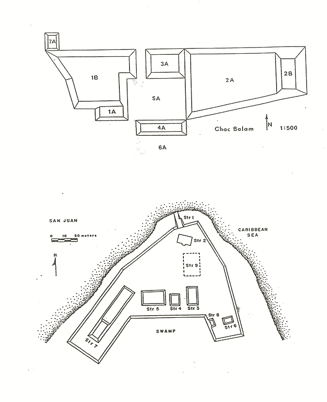
CHAC BALAM In the summer of 1987 excavations were initiated at the site of Chac Balam. It is located on the north end of the island adjacent to a small bay on the lee side and is only a few hundred meters from the opening of Boca Bacalar Chico canal (Figure 1). Access to the site is gained through an inlet on the bay. This inlet, approximately 10 meters wide, could have functioned as a harbor and may be man-made. Chac Balam is about 100 meters from the harbor. It is a formally arranged rectangular plaza group approximately 135 meters east-west by 50 meters north-south (Figure 3). At the center of the site is a low plaza approximately 25 meters square. It is surrounded on all four sides by platforms that vary in height from 3 to 6 meters. Preliminary ceramic analysis indicates that Chac Balam was constructed during the Late Classic with an initial light Early Classic component. Burial activity was heavy on Structures 1B and 2A. In the course of the excavations, 15 burials were encountered. Based on burial density, it is reasonable to suspect at least 100 or more additional burials. One burial was associated with an interior construction phase of Structure 1B. It consisted of an elite male associated with precious grave goods including two imported trickle-ware plates, a finely made black plate of local manufacture, a Belize polychrome cylinder jar with hieroglyphs, a matched set of greenstone earspools, a bone bloodletter, and a shell blood cup. Bloodletting has been identified as an important activity of Maya elite (Schele and Miller 1986, and Stuart 1984) and the presence of this ritual paraphernalia may indicate that the interred individual was the site ruler. His death was no doubt the inspiration for the enlargement of the mound in which he was buried. Two additional construction phases are associated with Structure 1B.
SUMMARY AND CONCLUSIONS
By 650 A.D. the Maya had established specific sites as transshipment points on northern Ambergris Cay. At that time a canal was cut through the peninsula at its narrowest point separating it from the mainland of what is now Mexico. Site location, the presence of imported goods, and architectural ties to Northern Yucatan, strongly suggest that the leeward side sites of San Juan and Chac Balam were important sites in the Maya maritime trade network. The site of Marco Gonzales on the south end of the island may have functioned in a similar way, servicing trade from the south. These sites were established adjacent to natural or artificial harbor facilities, exhibit formally arranged architecture, and in the case of Structure 3 at San Juan, show architectural ties to Chichen Itza and Nohmul. Communities on the windward side do not exhibit formal architecture except at Ek Luum and do not have high proportions of exotic goods. Additionally, they are not well situated to service maritime trade. At about 1000 A.D. the sites on the north end of the island are abandoned. During the Late and Terminal Classic one group of traders may have specialized in moving goods from one point to the next. Others moved goods from that point to the next point and so forth. A merchant class that moved goods along a route which included all points may not have emerged until the Late Postclassic. Why there is little or no occupation on the northern end of the island in the Late Postclassic when maritime trade was fully developed can not be answered at this point in time. It would appear that larger sites on Chetumal and Corozal Bays such as Santa Rita and Ixpaatun took over the functions of these small transshipment points. Perhaps this consolidation contributed to the enduring political structure at Santa Rita. The character of the Postclassic settlement on the island is largely unknown. After the abandonment of sites such as San Juan and Chac Balam, occupation continued in the island’s interior and south end. At this point in time it is not known if the occupation on the interior is a new occupation or a continuation of an older one. The Ambergris Cay Postclassic needs to be better known before the abandonment of the Terminal Classic sites can be fully understood. 
REFERENCES CITED
Andrews, Anthony P. 1983 Maya Salt Production and Trade. University of Arizona Press, Tucson.
Ball, Joseph W. 1977 The Ceramics of Becan, Campeche, Mexico. Middle American Research Institute, Tulane University, New Orleans.
Chase, Diane Z. 1979 The Ikilik Ceramic Complex at Nohmul, Northern Belize. Ceramica de Cultura Maya 12:71-81, Philadelphia.
1982 Spatial and Temporal Variability in Postclassic Northern Belize. Ph.D. dissertation, Department of Anthropology, University of Pennsylvania, Philadelphia.
Chase, Diane Z. and Arlen F. Chase 1982 Yucatec Influence in Terminal Classic Northern Belize. American Antiquity. 47:3, 596-613.
Garber, James F. 1981 Material Culture and Patterns of Artifact Consumption and Disposal at the Maya site of Cerros in Northern Belize. Ph.D. dissertation, Department of Anthropology, Southern Methodist University, Dallas.
1983 Patterns of Jade Consumption and Disposal at Cerros, Northern Belize. American Antiquity. 48:4, 800-807.
Graham, Elizabeth A. 1983 The Highlands and the Lowlands: Environment and Archaeology in the Stann Creek District, Belize, Central America. Ph.D. dissertation, Newham College, Cambridge University.
Graham, Elizabeth A., and David M. Pendergast 1987 Cays to the Kingdom. Archaeological Newsletter. Royal Ontario Museum, Toronto, Canada.
Guderjan, Thomas H., James F. Garber, and Herman A. Smith 1987 Transshipment Points and Facilities on Northern Ambergris Cay, Belize. Paper presented at the 1987 annual meeting of the Society for American Archaeology, Toronto, Canada.
Hammond, Norman 1976 Maya Obsidian Trade in Southern Belize. In Maya Lithic Studies edited by T.R. Hester and N. Hammond. Center for Archaeological Research, University of Texas at San Antonio.
Schele, Linda, and Mary Ellen Miller 1986 The Blood of the Kings: Dynasty and Ritual in Maya Art. Kimbell Art Museum, Forth Worth.
Stuart, David 1984 Royal Auto-sacrifice among the Maya: A Study of Image and Meaning. In Maya Iconography, edited by E.P. Benson and G. Griffin. Princeton University Press, Princeton.
Sidrys, Raymond V. and J.M. Andreson 1978 A Second Round Structure from Northern Belize, Central America. Man 13, 638-650.
|