Previous Thread
Next Thread
Print Thread
Page 15 of 16 1 2 13 14 15 16
SP Daily #420039 10/27/11 01:34 PM
Joined: Oct 1999
Posts: 84,398
Offline
Accuweather

Oct 27, 2011 11:44 AM

Hurricane Rina Nearing Yucatan Peninsula

Hurricane Rina is a Category 1 Hurricane located at 19.5° N, 87.1° W with maximum sustained winds of 70 mph, gusting to 85 mph

Rina remains still poses dangers as it approaches the Yucatan Peninsula today.

Rina has weakened to a tropical storm and will make landfall along the northeastern Yucatan coast near Cozumel later today or early tonight. Rina will then continue north along the coast later tonight into Friday before slowly shifting away to the east over the weekend. There will be damaging wind and flooding rain along the northeastern Yucatan coast today through Friday, tapering off Friday night. A storm surge of 1-3 feet will occur near and just north of the landfall. The latest satellite pictures show a significant disorganized area of clouds around Rina. This has caused winds to drop to 70 mph, and that trend will likely continue. Strong west-southwest winds aloft will weaken Rina even more over the weekend as the low-level center drifts eastward toward Cuba the mid-level feature heads across South Florida with heavy rain.

We have been monitoring an area of convection moving across the southern Caribbean. Although a trough is producing widespread showers and thunderstorms, development into a tropical system appears unlikely for the next several days.


SP Daily #420078 10/27/11 05:32 PM
Joined: Oct 1999
Posts: 84,398
Offline
[Linked Image]

TROPICAL STORM RINA ADVISORY NUMBER 19
NWS NATIONAL HURRICANE CENTER MIAMI FL
400 PM CDT THU OCT 27 2011

...AIR FORCE RESERVE HURRICANE HUNTER REPORTS THAT RINA CONTINUES TO
WEAKEN...


THE GOVERNMENT OF MEXICO HAS DISCONTINUED THE TROPICAL STORM WARNING FOR THE YUCATAN PENINSULA SOUTH OF PUNTA GRUESA.

REPORTS FROM AN AIR FORCE RESERVE HURRICANE HUNTER AIRCRAFT INDICATE
THAT MAXIMUM SUSTAINED WINDS HAVE DECREASED TO NEAR 60 MPH...
95 KM/H...WITH HIGHER GUSTS. ADDITIONAL WEAKENING IS FORECAST
DURING THE NEXT 48 HOURS...AND RINA COULD WEAKEN TO A TROPICAL
DEPRESSION BY SATURDAY.

TROPICAL STORM FORCE WINDS EXTEND OUTWARD UP TO 70 MILES...110 KM
FROM THE CENTER.

THE MINIMUM CENTRAL PRESSURE JUST REPORTED BY THE HURRICANE HUNTER
AIRCRAFT IS 992 MB...29.29 INCHES.

THE TROPICAL CYCLONE SHOULD MOVE
SLOWLY NORTHWARD NEAR THE EAST COAST OF THE YUCATAN PENINSULA FOR
THE NEXT 12-24 HOURS ON THE WEST SIDE OF A MID/UPPER-LEVEL RIDGE
OVER THE CARIBBEAN SEA. AFTER THAT...THE DYNAMICAL MODELS ARE IN
GOOD AGREEMENT THAT A COMBINATION OF RINA WEAKENING TO A SHALLOW
VORTEX AND RISING LOW-LEVEL PRESSURES TO ITS NORTHWEST SHOULD CAUSE
RINA TO TURN SOUTHWARD. WHILE THERE REMAIN DIFFERENCES IN THE
DETAILS...THE GUIDANCE SUGGESTS THAT RINA OR ITS REMNANTS WILL
MEANDER OVER THE NORTHWEST CARIBBEAN SEA OR THE ADJACENT LAND AREAS
FOR THE REST OF THE FORECAST PERIOD.

MODERATE TO STRONG SOUTHERLY VERTICAL WIND SHEAR IS LIKELY TO
PERSIST NEAR OR OVER RINA FOR THE NEXT 72 HOURS OR SO. THIS...
ALONG WITH LAND INTERACTION AND DRY AIR ENTRAINING INTO THE
CYCLONE...SHOULD CAUSE CONTINUED WEAKENING. BASED ON THIS AND THE
CURRENT TRENDS...THE NEW INTENSITY FORECAST CALLS FOR RINA TO MEET
AN EARLIER DEMISE THAN ON THE PREVIOUS ADVISORY...WITH THE CYCLONE
EXPECTED TO WEAKEN TO A TROPICAL DEPRESSION BY 48 HOURS AND TO
DEGENERATE TO A REMNANT LOW BY 72 HOURS. THE DYNAMICAL MODELS
SUGGEST THE SHEAR MAY DECREASE AFTER 72 HOURS. HOWEVER...GIVEN THE
UNCERTAINTIES OF THE STRUCTURE AND LOCATION OF THE REMNANTS OF RINA
THE FORECAST OF REMNANT LOW AT 120 HOURS WILL REMAIN UNCHANGED.


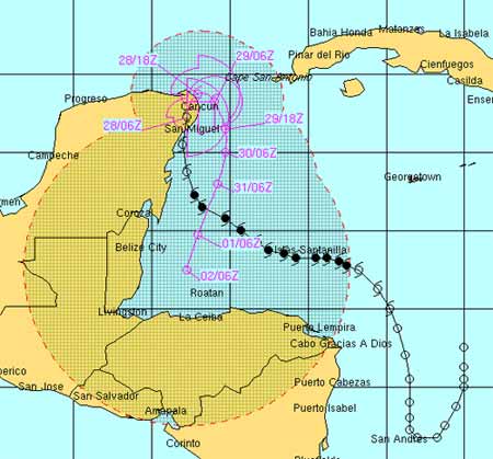
FORECAST POSITIONS AND MAX WINDS

INIT 27/2100Z 19.8N 87.2W 50 KT 60 MPH
12H 28/0600Z 20.6N 87.2W 45 KT 50 MPH...INLAND
24H 28/1800Z 21.3N 87.1W 40 KT 45 MPH...INLAND
36H 29/0600Z 21.2N 86.5W 35 KT 40 MPH...OVER WATER
48H 29/1800Z 20.9N 86.1W 30 KT 35 MPH
72H 30/1800Z 20.0N 86.0W 25 KT 30 MPH...POST-TROP/REMNT LOW
96H 31/1800Z 18.5N 86.5W 20 KT 25 MPH...POST-TROP/REMNT LOW
120H 01/1800Z 17.0N 87.0W 20 KT 25 MPH...POST-TROP/REMNT LOW

[Linked Image]


SP Daily #420079 10/27/11 05:40 PM
Joined: Oct 1999
Posts: 84,398
Offline
Tropical Storm Rina Affecting Cancun and Cozumel Tonight
Accuweather, Oct 27, 2011 5:26 PM

Rina continues to weaken. However, it is expected to slowly move north along the coast of the Yucatan Peninsula Thursday night. The main threat from Rina is heavy rainfall. Between 3-6 inches of rain is expected to fall across Cancun and Cozumel through the night. Wind gusts could be locally damaging, but Rina's winds will likely continue to diminish through tonight. The satellite picture continues to show Rina weakening. The center of circulation is now to the south of the strongest convection. The convection will continue to be ripped away from the low-level center of circulation through tomorrow. This will leave nothing more than a low-level swirl of clouds by the weekend.

SP Daily #420101 10/27/11 10:52 PM
Joined: Oct 2008
Posts: 19
K
Offline
K
[Linked Image]

SP Daily #420103 10/28/11 06:36 AM
Joined: Oct 1999
Posts: 84,398
Offline

Rina Weakens to a Tropical Storm
Accuweather

Oct 28, 2011 5:28 AM

Rina to Keep Harassing Cancun

Tropical Depression Rina is located at 21.8° N, 86.6° W with maximum sustained winds of 35 mph, gusting to 45 mph

Slow-moving and meandering Rina will continue to impact eastern parts of the Yucatan Peninsula and western Cuba for days.

Rina continues to weaken. However, it is expected to slowly move north along the coast of the Yucatan Peninsula this morning. The main threat from Rina is rainfall. Another 1-2 inches of rain is expected to fall across Cancun and Cozumel during the day Friday. Wind gusts could be locally strong, but Rina's winds will continue to diminish as the system weakens. The satellite picture continues to show Rina weakening. The center of circulation is now to the south of the strongest convection thanks to strong upper-level wind shear. The convection will continue to be ripped away from the low-level center of circulation today as shear is not expected to change much. This will leave nothing more than a low-level swirl of clouds by the weekend, when eventually Rina will turn around and begin to drift south and back out over the Caribbean as a remnant low.

We have also been monitoring a tropical wave over the southern Caribbean. Although the wave is producing widespread showers and thunderstorms, development into a tropical system appears unlikely for the next several days.

A third system, a low pressure center to the west of the Cape Verde Islands, is producing an area of area of showers and thunderstorms; however, due to wind shear aloft, it is currently not expected to develop into a tropical cyclone anytime of the next couple of days.


SP Daily #420141 10/28/11 08:44 AM
Joined: Oct 1999
Posts: 84,398
Offline


Things are back to normal in the country of Belize after a number of people were returned to their homes following evacuations due to Hurricane Rina. NEMO oversaw the return of islanders and other evacuees this morning. Huricane Rina continues to weaken and Will move slowly to the north near the northeast coast of the Yucatan Peninsula of Mexico today and Friday, likely as a weakening tropical storm. Even so, Rina is poses a threat of strong winds and maybe some storm surge and waves along portions of the North Eastern Yucatan coast. Meanwhile, there are no significant systems and no new tropical cyclones expected to form for at least the next couple of days. Rina is the 17th named storm of the Atlantic hurricane season.

PlusTV


SP Daily #420147 10/28/11 08:51 AM
Joined: Oct 2001
Posts: 6,267
Offline
Accuweather seems a bit off in calling Rina a CAT1 hurricane --- if the winds are 50MPH, Rina is not a hurricane.
The headline is right but the text is wrong - would hate to rely on their writers for important info.

thats a typo on my part Diane sorry about that. I fixed it....
Marty


Last edited by Marty; 10/28/11 12:28 PM. Reason: fix typo
Joined: May 2011
Posts: 1,520
Offline
Originally Posted by Diane Campbell
Accuweather seems a bit off in calling Rina a CAT1 hurricane --- if the winds are 50MPH, Rina is not a hurricane. The headline is right but the text is wrong - would hate to rely on their writers for important info.


You inadvertanlty (with much appreciation) turned me onto this site Diane, I really like it. Many thanks to San Pedro Weather (Amanda and Callum) for hosting the link... Storm Pulse


SP Daily #420205 10/28/11 12:29 PM
Joined: Oct 1999
Posts: 84,398
Offline

Rina pulls its punch
Jeff Masters

2:34 PM GMT on October 28, 2011

Tropical Storm Rina is being ripped apart by strong upper-level southerly winds creating 30 knots of wind shear over the storm. Visible satellite loops show that the low-level circulation of Rina is just a naked swirl over Cancun, on the northeastern tip of the Yucatan Peninsula. The shear has torn away Rina's heavy thunderstorms so that they lie about 200 miles to the northeast of the center. Cancun radar shows almost no rain affecting the northeastern Yucatan Peninsula and surrounding the waters, even though the center of the storm is directly over Cancun. Last night, Rina brought wind gusts of up to 41 mph to Cancun and 43 mph at Cozumel, where 8.20" of rain fell yesterday. Damage from Rina to Cozumel and Cancun should be very minor, and I expect the hotels there will be open for business today.

Rina will continue to be sheared apart today, with the low level center expected to drift slowly southwards along the Yucatan coast. Long range radar out of Key West shows that moisture streaming to the northeast from Rina is bringing rain to the Southwest coast of Florida. Rainfall amounts of 1 - 3 inches are likely over the Florida Keys and South Florida through Sunday due to moisture from Rina. Wind shear should be able to destroy the circulation of Rina by Saturday.


Figure 1. What tropical storm? It's hard to tell a tropical storm with 45 mph winds was centered over this beach in Cancun, Mexico this morning. Rina's heavy rains and strong wind were several hundred miles to the northeast of Cancun this morning, thanks to strong upper-level winds that sheared the storm apart.


Figure 2. Morning satellite image of Tropical Storm Rina showing the center of circulation over the northeast tip of the Yucatan Peninsula, and the heavy thunderstorms several hundred miles to the northeast of the center.

Elsewhere in the Atlantic
A broad region of low pressure in the Western Caribbean between Jamaica and Honduras is drifting slowly northwest at less than 5 mph. Heavy thunderstorm activity is disorganized and relatively modest, and NHC is giving the region a 10% chance of developing into a tropical depression by Sunday. Heavy rains from the disturbance will affect Honduras, the Cayman Islands, and Nicaragua Friday through Sunday. None of the reliable computer models are showing development of a new tropical depression in the Atlantic over the next seven days, though we will continue to see disturbed weather over the Western Caribbean that could generate something.


SP Daily #420223 10/28/11 01:12 PM
Joined: May 2011
Posts: 1,520
Offline
Ha! That little minx looks like she may just slip impotently through the channel into the Gulf with wings clipped and not rebound at all...hurray for Southerly Shearing Winds!

Page 15 of 16 1 2 13 14 15 16

Link Copied to Clipboard
April
S M T W T F S
1 2 3 4 5 6
7 8 9 10 11 12 13
14 15 16 17 18 19 20
21 22 23 24 25 26 27
28 29 30
Cayo Espanto
Click for Cayo Espanto, and have your own private island
More Links
Click for exciting and adventurous tours of Belize with Katie Valk!
Who's Online Now
0 members (), 127 guests, and 0 robots.
Key: Admin, Global Mod, Mod
Forum Statistics
Forums44
Topics79,204
Posts500,030
Members20,472
Most Online7,413
Nov 7th, 2021


AmbergrisCaye.com CayeCaulker.org HELP! Visitor Center Goods & Services San Pedro Town
BelizeSearch.com Message Board Lodging Diving Fishing Things to Do History
BelizeNews.com Maps Phonebook Belize Business Directory
BelizeCards.com Picture of the Day

The opinions and views expressed on this board are the subjective opinions of Ambergris Caye Message Board members
and not of the Ambergris Caye Message Board its affiliates, or its employees.

Powered by UBB.threads™ PHP Forum Software 7.7.5