In the NW Caribbean or Gulf of Mexico
There are currently no significant tropical disturbances in the Atlantic, but one is likely to form in the western Caribbean next week, and will have a good shot at developing into a tropical cyclone. The originating feature is a broad, deep-layer wave of low pressure located east of the lesser Antilles, most pronounced at the 500mb level in 18z GFS analysis. This is the system I mentioned in my video on Sunday as a potential threat next week. Although there are currently few clouds associated with this feature, that should change in a few days. The wave will move westward through the Caribbean, and once west of 75-80W, it will serve as a brake on the trade wind flow coming in behind it from the east. This will cause air to pile up and rise in the western Caribbean, and widespread thunderstorms will likely result. This will likely happen in 5-7 days, resulting in at least a weak area of low pressure in the western Caribbean.

As the low moves northwestward, it will be moving into a progressively more favorable environment as ridging balloons aloft over the NW Caribbean and an upper low backs away to the west, illustrated by the GFS Day 7 upper wind forecast. The WNW to ESE orientation of the jet stream to the north over the U.S. will likely allow upper ridging to continue ballooning into the Gulf of Mexico over the disturbance, an environment conducive for tropical development. None of the main global models show significant development of this disturbance, but given the favorable environment it will be moving into, I think it will be a threat to develop in the vicinity of the NE Yucatan Peninsula. The latest runs of the GFS have begun hinting at a tropical storm forming in the Gulf of Mexico, beginning to support this idea. The GFS and CMC ensemble means have also recently begun to show an increasingly wet NW Caribbean in about a week from now, indicating heavy precipitation associated with a strong tropical disturbance.
If a tropical storm does form in the NW Caribbean or southern Gulf of Mexico, its future track will be of obvious interest. The pattern a week from now is forecasted to feature a washed out (stalled) front draped over the southern U.S., evident as deeper blues in this forecast image. The upper trough that brought this front in is likely to stall near the eastern seaboard and leave a weakness over the eastern gulf through which our disturbance could move on a northeastward path towards Florida. However, given the washed out nature of the front with high pressure building behind it, it may be difficult for a disturbance near the Yucatan Peninsula to recurve into Florida. Also, the 500mb pattern for storms near the Yucatan Peninsula that end up hitting east of the Mississippi typically features a strong trough coming down from the Midwest, not a trough that is in the process of leaving the SE US like what is forecasted for next week. Thus, a more likely path to me currently seems to be westward or northwestward into the western Gulf of Mexico towards northern Mexico or southern Texas. However, considerable uncertainty exists, as this forecast is for at least a week from today, and the track of the disturbance may be influenced by whether it even develops into a storm or not. Details about the future of this system in the Gulf of Mexico will be better known in 5-7 days when it is trying to develop in the western Caribbean.
The concept chart below illustrates my overall thoughts for this system next week. I will likely post a video update in a couple of days, especially if the computer models begin to support development of this system.
Source
Tropical Development Possible In The Western Caribbean Between Wednesday & Friday Of Next Week; The Atlantic Looks Like It's Going To Light Up With Activity Starting Late Next Week
Rob Lightbown of Crown Weather Services
Friday, August 9, 2013 6:27 am
Tropical Development Possible In The Western Caribbean Later Next Week: It is looking quite possible that we are going to have tropical development in the western Caribbean between Wednesday and Friday of next week. The weather system behind this potential development is a trough of low pressure now located a couple of hundred miles east of the Windward Islands. This weather system is forecast to track westward reaching the southwestern Caribbean by Tuesday and Wednesday of next week. Once in the southwestern Caribbean, this weather system may serve as a catalyst for strong thunderstorm development & tropical development in that area by about Wednesday and Thursday of next week.
This weather scenario is now being picked up by many of the forecast guidance this morning. The latest GFS model guidance forecasts this system to gradually track northwestward reaching the Bay of Campeche next weekend and west-northwestward from there tracking inland along the coast of south Texas and northeastern Mexico around August 20th. The NAVGEM model is quicker with the development with some sort of tropical system developing by Tuesday and Wednesday of next week just south of Jamaica. The NAVGEM model guidance then forecasts this system to track northwestward reaching the far northwestern Caribbean and southernmost Gulf of Mexico by next Friday. The European model guidance also hints at development in the southwestern Caribbean around Tuesday and carries the energy of this system inland into Honduras and Guatemala by about Thursday. The FIM experimental model forecasts development near the coasts of Panama and Costa Rica around Tuesday and forecasts a northwestward track reaching the western Caribbean on Wednesday and near the northern tip of the Yucatan Peninsula on Thursday. The FIM experimental model then forecasts a west-northwestward track just north of the Bay of Campeche next Friday and a hurricane landfall just north of Tampico, Mexico around August 19th.
So, obviously this is going to be something that needs to be watched for closely. Now, what are my thoughts? Well, by the middle to later part of next week, the environment across the western and northwestern Caribbean is expected to be favorable for development and intensification of any tropical system; so, it seems quite possible that we may have a developing tropical cyclone in the western Caribbean after Wednesday of next week. It seems that the most likely track for any tropical system will be west-northwestward into the southern and western Gulf of Mexico by August 17th and 18th and thus a potential impact for south Texas and northern Mexico around August 19th and August 20th. With that said, this preliminary forecast is not at all set in stone and a lot can change in both intensity and track of any tropical system tracking through the western Caribbean and southern and western Gulf of Mexico.
I will be monitoring this potential system closely and will have updates on any potential development over the next several days. Residents, mariners and vacationers in the western Caribbean from western Cuba and the Cayman Islands to the Yucatan Peninsula and Belize should monitor this potential development for next week closely.

The Atlantic May Light Up With Activity As Early As Late Next Week & Next Weekend With An Active To Very Active Season Still Expected: The latest guidance seems to be now latching onto the idea I had several days ago that the lid is going to come off around August 15th. Many of the forecast guidance members are now showing multiple tropical systems tracking across the Atlantic between August 15th and August 25th.
The GFS model guidance continues to forecast a reversal in the overall weather pattern with a much more favorable environment for tropical development after August 15th from the Caribbean through much of the Atlantic. In fact, the latest GFS model is showing the development of up to 4 tropical cyclones in the Atlantic between August 15th and August 25th. Now, even though the European model guidance only forecasts out 10 days, it does show a couple of possible tropical cyclones in the eastern Atlantic in 10 days from now or on August 19th.
So, even though there is nothing going on this morning in the tropical Atlantic & that this weekend is expected to be quiet across the tropics, things look like they will become active as early as next weekend. Additionally, many parameters continue to point to an active to very active season, especially between August 15th and October 1st with a hurricane risk along the entire Gulf Coast, including the entire Florida Peninsula. Additionally, there is a very high risk along the Interstate 10 corridor from Houston to Tallahassee and everywhere in-between. Additionally, the islands of the northern Caribbean, including Hispaniola, Cuba and Puerto Rico will be at significant risk between August 15th and October 1st.
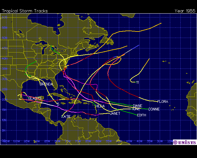
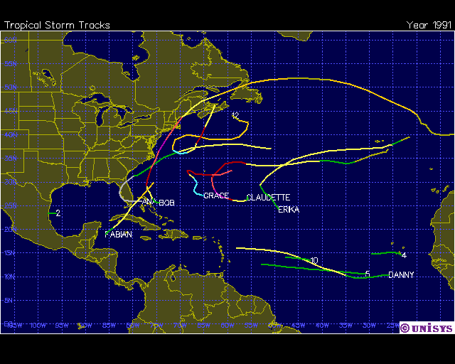
Finally, the US East Coast, especially the Mid-Atlantic states, Long Island and New England could face at least a close shave if not a landfalling tropical storm or hurricane. The weather pattern and many of the analog years point to a higher than average risk for the Mid-Atlantic states and New England. The latest analog guidance points to years such as 1991 (Hurricane Bob), 1961 (Hurricane Esther), 1955 (Hurricanes Connie and Diane) and even 1954 (Hurricanes Carol & Edna For New England & Hazel For North Carolina) has shown up at times in the analog guidance. Even 2004 and 2008 (which I am also leaning towards for analogs) had a couple of curving storms near the US East Coast, even though much of the activity both of those years were concentrated along the Gulf Coast and Florida Peninsula.
This doesn't mean that a tropical storm or hurricane will hit the Mid-Atlantic States and New England, but the pattern is such that any incoming tropical systems may be steered towards the north into the Mid-Atlantic States and New England.
Analog Guidance Based On Forecast Weather Pattern:


Activity During Some Of The Analog Years: