Previous Thread
Next Thread
Print Thread
Page 4 of 24 1 2 3 4 5 6 23 24
Joined: Oct 1999
Posts: 84,404
Marty Offline OP
OP Offline
More info: //ambergriscaye.com/forum/ubbthreads.php/topics/378224/

NAVY Track & projected wind speeds:

[Linked Image]

Joined: Oct 2001
Posts: 6,267
Offline
At the projected speed of 80 MPH the winds are really not a big deal.
I would stay off the seas starting sometime Sunday.

Joined: Oct 1999
Posts: 84,404
Marty Offline OP
OP Offline

TS Richard Staring Down Belize

October storms are notoriously unpredictable and fierce; the names Hattie and Mitch come readily to mind�. And now we may have another such storm. Tonight tropical storm Richard is hovering in the Caribbean sea 527 miles south east of Belize in the Caribbean sea, and the truth is, right now no one knows what he will do in the coming days.

So even though we have been spared so far this season by Tropical Storms Alex, Karl and Matthew- this one is a very real threat. According to the weatherman there are strong indications of it becoming a hurricane by Saturday. What does this mean for Belize? And should we be getting prepare to weather another storm over the weekend? Today Seven News took a visit to the met office to get some answers.

Dennis Gonguez, Chief Meteorologist
"Last night at 9 pm the 19th tropical depression form for this season and that was located about 160 miles south of the Cayman Islands. By 9 am this morning it had intensified and became this 17th tropical storm of this season and name Richard. Presently it's about 525 miles east south east of Belize City and at 9 o' clock it was specifically located at latitude 16.2 north 80.4 west. Maximum sustain winds of 40 miles per hour and it was moving towards the south east at 6 miles per hour. Presently it is moving towards the southeast but its forecast to take a more southerly track and eventually a more north westerly track. That puts us pretty much in its path over this weekend. The first indications are that the storm will travel toward the north of Belize but then again those forecasts can change with each update. One of the issues with this system is that presently the way its behaving is as though it adjusting itself and pointing directly at us. Indications are that it will be a hurricane by Saturday morning off the northeast tip of Honduras. So the season isn't over we still have a long ways to go so we should remain vigilant and be prepared for any eventuality."

Monica Bodden
"Mr. Gonguez following a pattern with storms in October. Are storms in October considered to be erratic."

Dennis Gonguez, Chief Meteorologist
"Yea they do, the steering currents are usually weak in October and that's why this one here has been behaving a bit erratic it's heading towards the south east now eventually heading south and turning towards the North West. So the steering is usually weak during this time of the year. We need to watch this system for the weekend, we need to remain vigilant, this system could pose a threat to affect us this weekend so we need to be very vigilant of where this system is going and whether it intensifies."

In the 6:00 pm report issued by the National Hurricane Center - Tropical Storm Richard moving south-southeast at a mere two miles per hour with winds of 40 miles per hour - which means the storm ahs not strengthened since it was upgraded to a storm earlier today.

THE GOVERNMENT OF HONDURAS HAS ISSUED A TROPICAL STORM WATCH FOR THE COAST OF HONDURAS FROM THE NICARAGUA/HONDURAS BORDER WESTWARD TO LIMON. v A tropical storm watch is in effect for Houndras from the Nicaragua Honduras Border westward to Limon.

The National Meteorological Services say they will continue to monitor the progress of Tropical Storm Richard.

Channel 7


Joined: Oct 1999
Posts: 84,404
Marty Offline OP
OP Offline

Will Tropical Storm Richard drench our shores?

The end of the hurricane season is in sight but threats are still looming. With five weeks to go before it officially closes, another weather system is may be heading this way. On Wednesday night the seventeenth named Tropical Storm, Richard, formed about a hundred and sixty miles south of the Cayman Islands. Earlier today, four out of six models placed Tropical Storm Richard crossing right through Belize this coming weekend. Chief Meteorologist, Dennis Gonguez, says while that is the case, it is still too early to tell, but the prudent thing is to do is to always be prepared.

Dennis Gonguez, Chief Meteorologist

"As the system nears the northeastern tip of Honduras, it could develop into a hurricane; it could strengthen into a category one hurricane. And as it heads towards us further strengthening can be expected as conditions near to Belize, will become more conducive to development. So we could have the possibility of a category one hurricane in our doorsteps come Sunday."

Marion Ali

"What do the projections show so far most likely scenario?"

Dennis Gonguez

Dennis Gonguez

"Well the most likely scenario indicates that landfall will quite likely be to the north of Belize between Belize and Cancun, however there is a large uncertainty at that time so it could be anywhere within this area at landfall. So there is a large uncertainty going out to seventy-two hours and beyond. This point is presently five hundred and twenty-miles east south east of Belize City. However landfall can be anywhere from northern Belize to Cancun, Mexico."

Marion Ali

"So the south of Belize need not worry?"

Dennis Gonguez

"The entire country needs to be concerned about this system because the system isn't just a point, it's an area. So even if it makes landfall well to the north of us, the southern parts of the country can still feel the effects. So its not just a point. The point is just used to track the center of the system; where it is going. We have to understand it's an area."

Marion Ali

"Is there any other weather system or phenomenon out there that can affect how this system behaves over the next few days?"

Dennis Gonguez

"Well not at this time. It seems that the steering currents will be weak and the system will head towards west north west at this present time."

Marion Ali

"West north west meaning Belize and neighboring countries."

Dennis Gonguez

"Yes, in our general direction."

Gonguez advises everyone to monitor the local radio stations for updated alerts of the movement of Tropical Storm Richard. More on this later in the newscast in the weather report.

Channel 5


Joined: Oct 1999
Posts: 84,404
Marty Offline OP
OP Offline
Statement as of 11:00 am EDT on October 22, 2010

...Hurricane Watch and Tropical Storm Warning issued for
northeastern Honduras....


summary of 1100 am EDT...1500 UTC...information
-----------------------------------------------
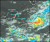
location...15.8n 81.1w
about 150 mi...240 km ENE of Cabo Gracias a Dios on nic/Hon border
maximum sustained winds...40 mph...65 km/hr
present movement...W or 265 degrees at 3 mph...6 km/hr
minimum central pressure...1006 mb...29.71 inches

Tracks remain about the same, slightly more to the south

Track & projected times:

[Linked Image]

despite satellite imagery that suggests that Richard is better
organized...data from an Air Force Reserve hurricane hunter
indicate that the storm has not strengthened
. Maximum flight
levels winds were about 40 kt...with believable SFMR values near 35
kt...and a central pressure of 1006-1007 mb. In addition...the
flight level winds suggest the system has become elongated from
north to south...and perhaps the center is trying to reform farther
south. The initial winds will stay 35 kt for this advisory.
It does appear as though the environment is becoming more conducive
to strengthening.
Vertical wind shear is rather light and drier
air to the northwest is gradually modifying and is farther from the
center than yesterday. Most of the intensity models respond to
this by intensifying Richard into a hurricane. The official
forecast will stay closer an average of the statistical guidance...
though the category two solution of the GFDL/HWRF is not
unrealistic. Although it is not explicitly forecast
below...Richard is expected to strengthen between the 48-hr and
72-hr forecasts up to landfall. After that...shear is expected to
be rather strong over the Gulf of Mexico...making restrengthening
unlikely.

A westward motion has seemingly begun with Richard as ridging is
beginning to build over the Gulf of Mexico. This ridge is expected
to strengthen some during the next couple of days...which should
steer the storm to the west and west-northwest at an increasing
forward speed.
Model guidance has come into better agreement on
this pattern...though there are some differences by the end of the
period. The NHC forecast is shifted southward a little bit to
account for current models trends.

Joined: Oct 1999
Posts: 84,404
Marty Offline OP
OP Offline
NOAA Statement as of 2:00 PM EDT on October 22, 2010

...Richard expected to intensify later today....

summary of 200 PM EDT...1800 UTC...information
----------------------------------------------
location...15.8n 81.3w
about 140 mi...225 km ENE of Cabo Gracias a Dios on nic/Hon border
maximum sustained winds...40 mph...65 km/hr
present movement...W or 270 degrees at 3 mph...6 km/hr
minimum central pressure...1006 mb...29.71 inches

How close can it get?
http://www.stormcarib.com/closest.cgi
- - Closest Point of Approach - -

Results for 17.91667N, 87.95000W (San Pedro):
The approximate Closest Point of Approach (CPA) is located near 17.7N, 88.1W or about 18.5 miles (29.9 km) from your location. The estimated time of when the center of the storm will be at that location is in about 69.4 hours (Monday, October 25 at 8:24AM EDT). (6:24am Belize Time).

(they have it going a lil south of the island)

Joined: May 2000
Posts: 7,074
Likes: 3
Offline
My house is 17.53.33 N and 87.58.45 W

Joined: Oct 2001
Posts: 6,267
Offline
EEK. Seriously.


Joined: Jun 2005
Posts: 2,018
Offline
Originally Posted by Amanda Syme
My house is 17.53.33 N and 87.58.45 W

We'll be praying for you Amanda and the rest of Belize.


I'm happier than a pig in s__t...a foot on the sand...and a Belikin in my hand!
Joined: May 2000
Posts: 7,074
Likes: 3
Offline
Thanks Al K. Looks like Guanaja will be dead centered. Let's pray that it is just a cat one, little wind and moving fast!

Page 4 of 24 1 2 3 4 5 6 23 24

Link Copied to Clipboard
June
S M T W T F S
1 2 3 4 5 6
7 8 9 10 11 12 13
14 15 16 17 18 19 20
21 22 23 24 25 26 27
28 29 30
Cayo Espanto
Click for Cayo Espanto, and have your own private island
More Links
Click for exciting and adventurous tours of Belize with Katie Valk!
Who's Online Now
0 members (), 335 guests, and 0 robots.
Key: Admin, Global Mod, Mod
Forum Statistics
Forums44
Topics79,264
Posts500,176
Members20,755
Most Online20,577
Mar 30th, 2026
2


AmbergrisCaye.com CayeCaulker.org HELP! Visitor Center Goods & Services San Pedro Town
BelizeSearch.com Message Board Lodging Diving Fishing Things to Do History
BelizeNews.com Maps Phonebook Belize Business Directory
BelizeCards.com Picture of the Day

The opinions and views expressed on this board are the subjective opinions of Ambergris Caye Message Board members
and not of the Ambergris Caye Message Board its affiliates, or its employees.

Powered by UBB.threads™ PHP Forum Software 7.7.5