|
|
Joined: Oct 1999
Posts: 84,398
|
OP

|
Monthly Weather Summary, September 2016
National Meteorological Service of Belize
September 2016 in Belize was mostly moist, especially over the south and over inland areas. The first day started with a few showers and isolated thunderstorms over the south. On the second and third day, fair weather prevailed, with only isolated showers and isolated thunderstorms. On the second night, however, the south experienced a few more.
On the fourth day, a weak tropical wave approached the country. This wave was associated with moisture preceding it and so a few showers and thunderstorms affected the country on the fourth and fifth. The following two days were sunny and fair with isolated showers and isolated thunderstorms.
Another tropical wave affected the country on the eighth and ninth day. The north of the country experienced the bulk of the rainfall. Mainly fair weather followed on the tenth and eleventh day, except for afternoon hours, when inland areas experienced a few showers and thunderstorms.
On the twelfth, the country experienced early morning coastal showers and inland afternoon showers. That same night, another tropical wave crossed the country, spreading showers and thunderstorms around the country.
From the thirteenth to the twenty-first, relatively moist and unstable conditions supported a few showers and thunderstorms over the south and coast at night and over inland areas in the afternoons. Showers continued around the country on the twenty-second and twenty-third , when yet another tropical wave crossed the country.
Over the following three days, relatively moist and unstable conditions supported a few showers, thunderstorms and periods of rain around the country. On the twenty-eighth and twenty-ninth, another tropical wave approached and crossed the country, but supported no significant rainfall. However, on the last day of the month, an upper-level trough over the area, supported unstable atmospheric conditions. At the same time, low-level moisture increased and so the country experienced a few showers and thunderstorms.
In conclusion, the country experienced a relatively moist September in 2016. Five tropical waves were noted to have crossed the country, supporting showers and thunderstorms, except for one that produced no significant rainfall. Apart from these rain makers, moist and unstable conditions were the other supporting factors for the rainfall this month. Present data shows that this September rainfall fell within the normal range for this time of the year.
�
|
Station
|
September
|
Normal
|
|
Libertad
|
111.9
|
198.1
|
|
Towerhill
|
187.8
|
191.6
|
|
Philip Goldson Airport
|
160.7
|
258.8
|
|
Central Farm
|
88.6
|
177.4
|
|
Middlesex
|
246.5
|
354.8
|
|
Melinda
|
260.2
|
241
|
|
Spanish Lookout
|
130.8
|
174.4
|
|
Savannah Forest Stn�������
|
393.9
|
365.3
|
 Click image for larger version
|
|
|
|
|
Joined: Oct 1999
Posts: 84,398
|
|
OP
|
Monthly Weather Summary, October 2016
National Meteorological Service of Belize
The month of October saw below average rainfall for most stations as rainfall from tropical waves were limited. Weather conditions were affected by persistent low surface pressures over the southwestern and western Caribbean Sea and transient upper level Tutt lows.
A few showers occurred over the north and coast over-night into the 1st and over the mountains in the south during the daytime. The broad circulation of Category 4 Hurricane Matthew centered over the southeastern Caribbean dominated our weather during the first few days of the month. This supported a light and relatively dry northeasterly airflow during the 2nd through the 4th as Matthew moved north across the Caribbean towards western Hispaniola / Haiti and eastern Cuba. At upper levels a Tutt low over the western / central Caribbean moved west of our area by the 2nd and back east of our area by the 5th. This initially supported a convergent northwesterly flow aloft. However on the 2nd it supported isolated thunderstorms in the vicinity of the PGIA and the northern slopes of the Maya Mountains. Then by the 5th and the upper level northwesterly flow became a bit convergent. Weather conditions were mainly fair during the 7th, however during the 8th to 11th a relatively slack pressure gradient supported light winds and in a deep layer southerly flow with increasing upper level moisture, isolated thunderstorm developed in the south at night-time with showers and rain spreading across the country.
The upper levels became drier by Wednesday 12th due to a north-northwesterly flow from a ridge to the west. At low levels a surface trough across the northwestern Caribbean supported a north-northeasterly flow and mainly fair conditions through Thursday 13th. High resolution satellite imagery detected a cyclonic swirl of low clouds centered near 18N 84W and this produced showers over and offshore the south over-night and along the north coast and higher elevations inland during the daytime. This activity was supported by a weakly divergent westerly - southwesterly flow aloft from an upper level low south of western Cuba. This pattern of diurnal shower activity continued Through the 16th. During the 17th and 18th, light winds resulted in land breeze effect over-night. Showers developed mostly over the sea due to coastal convergence and shower activity affected the south and coastal areas during the night and early morning hours with additional activity developing inland and in the higher elevations at peak daytime heating hours. During the 19th showers moved from the sea to northern coastal areas. Then with the upper level high centered over the Gulf of Tehuantepec, the resulting northwesterly flow supported a drying trend through the 20th. Night-time / early morning showers were confined to mostly coastal waters during the 21st with isolated showers over the Maya mountains on the 22nd.
By the 23rd a cold front stalled over northern Yucatan with a shear-line developing between Hisopaniola and northeastern Nicaragua. Over our area a convergent / long fetch northeasterly flow developed, while at upper levels a trough extended down to the northwestern Caribbean with a ridge extending north from the eastern Pacific across Mexico and into the central United States. Afternoon showers affected mostly southern and inland areas, becoming generally isolated over-night into Monday 24th.
Remnant moisture from the dissipating frontal boundary drifted south and southwest from the northwestern Caribbean and supported mostly low-topped showers and periods of rain over most areas during the 25th. By the 26th a Tutt low was centered over Yucatan and provided support for a surface trough extending from the Bay of Campeche to the northwestern Caribbean Sea. Showers, periods of rain and isolated thunderstorms developed over and offshore northern and central areas of the country through the 27th. During the 28th a surface low over the northwestern Caribbean supported a northwesterly flow over our area and weather conditions turned out mainly fair with clear skies at night and little or no rainfall.
Cloudy conditions (layered low and high clouds) prevailed during the 29th and 30th with a moist southerly flow aloft and northwesterly low level flow which confined most showers and thunderstorms to coastal waters east of the reef. However by the evening, showers and thunderstorms developed from near SandHill south-southeastwards to just west of Dangriga and drifted westwards, with a few more developing over southern coastal waters during the night.
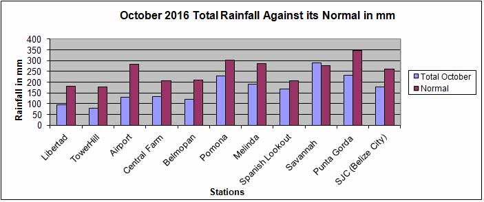
| Station |
Total October 2016 |
Normal |
| Libertad |
96 |
181.8 |
| Tower Hill |
79.2 |
178.6 |
| Airport |
128.9 |
281.9 |
| Central Farm |
131.8 |
205.1 |
| Belmopan |
121 |
209.6 |
| Pomona |
229.4 |
301.1 |
| Melinda |
190.1 |
287.3 |
| Spanish Lookout |
169.3 |
205.9 |
| Savannah��� |
290.6 |
277.5 |
| Punta Gorda� |
232.2 |
346.6 |
| SJC (Belize City) |
178.6 |
259.6 |
|
|
|
|
|
|
|
|
Joined: Oct 1999
Posts: 84,398
|
|
OP
|
Monthly Weather Summary, November 2016
National Meteorological Service of Belize
The month of November saw above average rainfall over central portions of the country; while the south and north saw below average, with the north well below. Two rain events, one at the begriming of the month and the other near the end, were primarily responsible for the greater than normal rainfall over central areas. Only one weak cold front crossed the country, and the predominant surface flow was from the northeast. No new temperature record was set.
The month started out with some rain. A surface trof that extended from Belize eastward was the focus for showers and thunderstorms during the first two days, especially in the nights. The moisture was high and the upper pattern diffluent, with an upper anticyclone centered over our area. Belize City received more than four inches of rain on the 2nd, while San Pedro and some central stations got more than two inches. The next three days (3rd,4th,5th) saw a few showers over some areas, as the trof drifted south and dissipated and a moderate northeast surface flow, supported by a ridge over the western Gulf of Mexico, prevailed. The upper pattern was neutral. The moisture decreased and showers were isolated from the 6th to the 8th. A broad low level trof over the central Caribbean Sea resulted in a light northeast airflow over the northwest Caribbean and Belize.
From the 9th to the 12th a few showers developed mainly in a diurnal manner; ie mostly inland during the daytime and over the coast at night. A light north-northeast airflow was supported by a surface trof over the NW Caribbean Sea just east of Belize and a ridge over southern Mexico. Some southern coastal stations recorded one to two inches on the 11th and 12th. A decrease in available moisture resulted in mainly fair weather, with only isolated showers, on the 13th, then a few showers over the south the next day. It was mostly sunny on the 15th with little or no rain. A light northerly airflow prevailed and a weak cold front reached NW Yucatan. The cold front crossed Belize the next day with a few showers and light rain developing mainly over central and southern districts. Rainfall was minimal with this front, and mostly less than one quarter of an inch. The 17th and 18th saw isolated showers mainly over the south, as a northeast airflow prevailed. A broad low pressure area developed over the SW Caribbean Sea east of Nicaragua and high pressures dominated the Gulf of Mexico. The flow backed to the NNE the next two days (19th, 20th) and mainly fair weather prevailed over the mainland, while a few showers developed over the sea. The moisture was relatively low and the upper pattern generally convergent.
Skies became cloudy on the 21st with a few showers and light rain over central and southern areas, as tropical storm Otto formed east of Nicaragua. Otto would remain almost stationary, become a hurricane, then cross over southern Nicaragua on the 24th. Meanwhile, a few showers prevailed over the country through the 24th, except on the 22nd, when showers were isolated. Melinda recorded four and one half inches of rain on the 24th. High pressures dominated the Gulf of Mexico and north-easterlies prevailed over Belize over these days, as another cold front reached northern Yucatan on the 21st, then moved east without crossing Belize. Skies became overcast on Friday 25th with frequent showers and periods of rain over most areas. A moist north-northeasterly airflow, that was convergent over and just east of Belize, prevailed. Rainfall was heaviest along the coast and over the south. Belize City recorded more than four inches of rain for 25th, and some streets were flooded all day. The next day, showers and rain decreased during the morning, to become generally isolated by evening. The moisture decreased and winds became northeast by Sunday 27th and showers remained isolated. The flow then veered to the southeast during the last three days and the moisture decreased, which supported only isolated showers. The surface ridge moved east and out of the Gulf of Mexico, while low pressures developed over the western Gulf and NE Mexico/ Bay of Campeche ahead of a cold front that entered the NW Gulf of Mexico the last day of the month.
|
|
|
|
|
Joined: Oct 1999
Posts: 84,398
|
|
OP
|
Monthly Weather Summary, December 2016
National Meteorological Service of Belize
Climatology shows that the main features influencing weather across the country of Belize in December are cold fronts, upper level troughs and the development of moist northeasterly airflows in the area. There was no frontal passage in December of 2016. However, rainfall was above normal for most areas and this was caused by a rather moist tropical air mass that affected the country. Additionally, an upper level ridge persisted over the southwest Caribbean for a major part of the month. This blocked the fronts from entering the area and also supported instability aloft which resulted in deep convection over the area particularly on the 26th of the month.
On the first day of December a marginally moist and light easterly airflow over the area supported cloudy skies at times with a few showers mainly over northern coastal areas of the country. A slack pressure pattern dominated from the 2nd through to the 3rd and moisture also decreased over the area. This supported mainly fair conditions with only isolated showers across the country. The flow veered even further to the east-southeast on the 4th and 5th supporting mainly fair, warm and mostly dry weather. Similar weather continued on the 6th but isolated showers affected inland areas on that day.
In response to a cold front that descended into the Bay of Campeche on the 7th and later became stationary over extreme northern Yucatan, the surface flow backed to the east on the 7th and then to the east-northeast on the 8th through to the 11th. This resulted in a gradual increase in moisture over the area. While the 7th was still mainly fair with only isolated showers, the 8th became cloudy at times with a few showers across the country and similar weather persisted through to the 11th of the month.
Moisture would increase further on the 12th as a trof developed over the western Caribbean linked to a low pressure system crossing Nicaragua. This resulted in cloudy skies with a few showers and periods of rain. The trof was almost over the country on the 13th causing a moist northeasterly surface flow to develop. Furthermore, the upper levels were quite divergent and this supported cloudy skies with several showers, periods of rain and thunderstorms over the country. This was the first major rainfall event for the month resulting in rainfall totals of over an inch in the Belize City, Ladyville and the San Pedro Area. Conditions continued moist and unstable on the 14th but rainfall occurred mostly in the south that day with Punta Gorda receiving about an inch of rainfall.
Moisture decreased on the 15th and 16th but a few showers still affected southern and central areas of the country. Improvements continued on the 17th as the flow veered more to the east and by the 18th a dry easterly to southeasterly flow supported mainly fair conditions with only isolated showers.
The surface flow shifted abruptly to the east-northeast on the 19th as a cold front entered the central Gulf of Mexico. Additionally, the flow was convergent and gusty over the area. This factor coupled with an increase in moisture supported cloudy skies at times with a few showers across the country on the 19th and 20th of the month. Additionally, a broad trof developed over the northwest Caribbean on the 20th and persisted through to the 21st. Therefore, the gusty northeasterly flow persisted but showers decreased on the 21st. By the 22nd conditions were mainly fair with only isolated showers. Conditions continued relatively dry over the area on the 23rd but moisture increased later in the night resulting in an increase in showers.
Conditions were relatively moist on the 24th and 25th resulting in cloudy skies at times with a few showers. These occurred mostly in the south on Christmas Day. Weather conditions deteriorated further on the 26th as an upper ridge east of the area coupled with trofing to the west supported a divergent and moist South-Southwesterly flow aloft. Skies were cloudy to overcast that day with some showers, thunderstorms and periods of rain over most areas. This was the second major rainfall event for the month. Belmopan in the west and Kendall in the south recorded almost an inch and a half of rainfall.
Relatively moist conditions persisted over the area from the 27th through to the 29th although the upper levels had become less divergent. The result was cloudy skies at times with a few showers mainly over central and southern areas. Moisture decreased further on the 30th and 31st resulting in partly cloudy skies with shower activity becoming generally isolated.
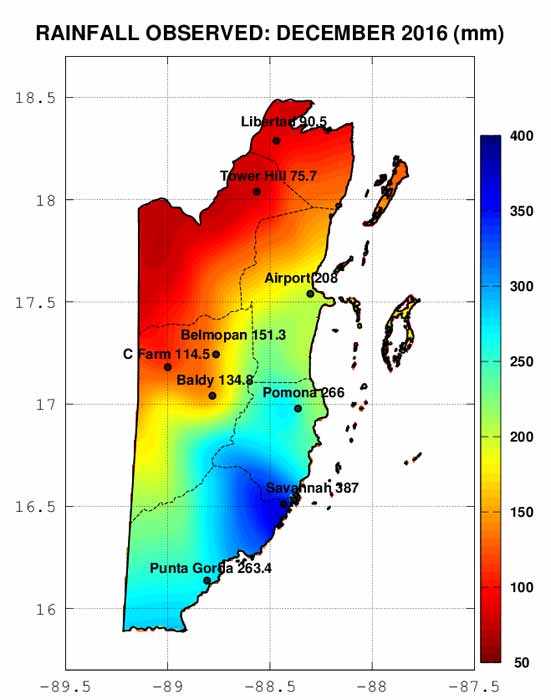
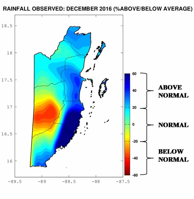
The graph and maps below show the rainfall recorded in December 2016 versus the climatological mean for the month for a few of the weather stations across the country. These graphics show most stations recorded above average rainfall except for those in the western Cayo District that recorded below average.

|
|
|
|
|
Joined: Oct 1999
Posts: 84,398
|
|
OP
|
Monthly Weather Summary, January 2017
National Meteorological Service of Belize
January 2017 started out with beautiful weather. For the first three days, a dry south-easterly flow prevaile, which supported little or no rainfall. On the fourth day, only isolated showers were observed, followed by the fifth and sixth, experiencing fair conditions.
On the seventh, the country experienced pre-frontal activity. Showers and thundershowers were observed, followed by the passage of a cold front.� The eight day met dry and gusty conditions. Wind speeds ranged between fifteen and thirty knots.� On the ninth, wind speeds abated, but dry conditions continued. However, a few showers were observed around the country during the night.
From the tenth through to the seventeenth, a series of high pressure ridges traversed the Gulf of Mexico and the Northwest Caribbean Sea.� These supported and maintained a relatively moist north-easterly flow across Belize. The country experienced light showers each and every day during this period.
Conditions changed with the onset of a dry east to south-easterly flow from the eighteenth to the twenty-first. Once again, fair conditions prevailed with little or no rainfall.
On the twenty-second night, another cold front crossed the country. This time, pre-frontal activity was minimal. Only the Corozal District experienced light isolated showers.
From the twenty-third to the twenty-seventh, fair, cool and dry conditions prevailed. The twenty-eight was met with isolated showers , followed by a few showers on the twenty-ninth, with the passage of a third cold front. The thirtieth was dry and windy, while the last day was cool and dry.
In conclusion, observation showed three cold fronts crossed Belize during January, 2017. Only the first was accompanied by a few thundershowers. Rainfall data collected indicated that rainfall for this month� was below normal.�
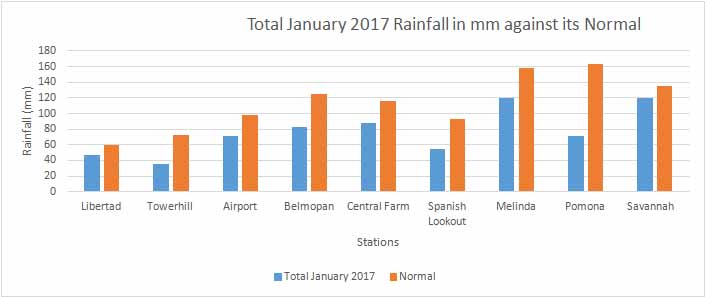
| Station |
Total January 2017 |
Normal |
|
| Libertad |
47.3 |
59.4 |
|
| Towerhill |
35.4 |
72.4 |
|
| Airport |
71.7 |
98.3 |
|
| Belmopan |
82.8 |
125 |
|
| Central Farm |
87.7 |
115.6 |
|
| Spanish Lookout |
54.6 |
93.4 |
|
| Melinda |
120.4 |
157.9 |
|
| Pomona |
70.9 |
162.7 |
|
| Savannah��� |
119.7 |
135.7 |
|
|
|
|
|
|
Joined: Oct 1999
Posts: 84,398
|
|
OP
|
Monthly Weather Summary, February 2017
National Meteorological Service of Belize
February 1st 2017 saw a light easterly surface flow prevailing, while at upper levels a trough east of our area supported a convergent / subsident northwesterly flow over our area. Mostly cloudy skies prevailed with little or no rainfall over the mainland, while a few showers over central coastal waters early, drifted on-shore with a few more developing inland during the afternoon and and over-night into the 2nd. Light winds supported some coastal convergence and isolated early morning showers into the 3rd. During the next few days through 13th an east-northeasterly flow supported low level moisture through the lower 10,000ft and night-time / early-morning showers occurred over the south and some central areas of the country.
Mainly fair, warm and dry weather prevailed during Tuesday 14th through Monday 20th as the upper level pattern continued convergent / subsident and a light to moderate east-southeasterly surface / low level flow developed. During the 15th and 16th a frontal boundary was positioned over the Bay of Campeche and a pre-frontal shear-line drifted across Yucatan - Guatemala and northern Belize over-night but supported only isolated showers in the northwesterly flow along with isolated afternoon showers resulting from day-time heating over the Maya Mountains. The shear-line rapidly weakened as it retrogress over the area with the southeasterly flow returning. Upper level moisture increased during Friday 17th as a trough moved nearer our area, while a cold front stalled across central Yucatan then retrogressed and dissipated while the east-southeasterly surface / low level flow continued to dominate.
By the 20th a deep layer trough to the west and northwest supported rapid deepening of a surface low over Texas / Louisiana. the low ejected across he southeastern United States with the associated cold front swinging east and sotheast to Yucatan by the 22nd, while a pre-frontal triough drifted over our area and into the northwestern caribbean sea. The relatively weak frontal boundary would eventually drift over the extreme Northwest Caribbean by Wednesday 22nd, while the associated shear-line continued southeast to southern Costa Rica / Panama. Few showers affected the south during the afternoon / evening of the Tuesday 21st and the northern / central areas through early night-time. A few more showers developed over the northern districts over-night into the 22nd and drifted eastwards to coastal waters by day break. early morning temperatures were slightly cooler where as relatively warm daytime temperatures occurred during Wednesday 22nd through Friday 24th.
An east-southeasterly airflow supported mainly fair weather during 23rd and 24th with isolated afternoon thunderstorms developing over the Maya Moutains during the 25th. By the 26th broad troughing developed over the Northwest Caribbean and supported an east-northeasterly flow. The trough sheared northwestward across Yucatan and the flow veered to the southeast by the 26th with insignificant increase in moisture and shower activity. Mainly fair weather continued during Monday 27th and Tuesday 28th.
|
|
|
|
|
Joined: Oct 1999
Posts: 84,398
|
|
OP
|
Monthly Weather Summary, March 2017
National Meteorological Service of Belize
The month of March in Belize is typically characterized by windy conditions, with winds blowing generally from the East; March climatologically has the highest average wind speed. While thunderstorm activity would be limited during this time of the dry season, some areas of the country would experience light to moderate showers or rain. Normal rainfall amounts would range from about 30mm over northern parts of the country, to about 80mm over southern parts of the country. This March of 2017 saw only one cold front crossing Belize near mid-month, supporting a few days of mild / relatively cool temperatures across the country.
On the first day, Belize experienced a seasonably moderate (10-20 knots) easterly surface flow, with skies being clear to partly cloudy. Showers were isolated, and concentrated especially over southern areas of the country. Winds continued moderate, becoming gusty for a few days, then backing to become east-to-northeasterly from the 2nd to the 11th of the month. During this time, water vapor satellite imagery showed that the upper levels remained relatively dry over Belize. Showers were generally isolated on the 2nd. Then, a cold front - which had crossed the Gulf of Mexico and entered the northern Caribbean around the 4th - had become stationary near Jamaica area. The east-to-northeasterly surface flow brought over pockets of moisture from the western Caribbean waters. As a result of pre-frontal activity and the passing of the front over the northwestern / western Caribbean, the 3rd to the 11th saw some cloudy spells, along with a few showers affecting mostly central and southern areas of the country. There was a break on the 9th, however, where little rainfall was noted on radar imagery.
From the 12th to the 16th, the upper levels were shown to be relatively moist over Belize area. On the 12th and 13th, the surface winds had veered to become east-to-southeasterly, and lighter, as the pressure gradient had slackened over the area. With such an airflow at the surface, skies were partly cloudy with characteristically relatively drier conditions. Only isolated showers were noted, with a possible isolated thunderstorm developing over the Maya Mountains area in the afternoon of the 12th. Later on, the pressure gradient tightened once more over the area, and winds backed to become north-to-northeasterly, also becoming gusty at times. With a relatively moister airflow, skies were noted to be mostly cloudy during the 14th to the 16th. A few showers and isolated thunderstorms were noted over the north and along some coastal areas of the country at first, supported by pre-frontal activity; and then, a few showers affected mostly coastal/offshore areas, as well as central and southern mainland areas, including the Maya Mountains. During the night of the 15th, mostly clear skies were observed, with cool overnight temperatures in the wake of the passing of the cold front. This cold front had become stationary over Jamaica/Eastern Cuba area for a few days afterwards, providing pockets of moisture to flow over Belize with the northeasterly airflow.
The final couple weeks in the month saw clear to partly cloudy skies with the weather being mainly fair, and only isolated showers developed during the 17th to the 24th. Middle to upper levels had become mostly dry once again. Meanwhile, low level moisture capped near the surface had been supported by moderate and gusty northeasterly airflow, which had backed to become north-to-northeasterly by the 19th. Onwards, surface winds veered and weakened, becoming east-to-northeasterly through to the 23rd; becoming predominantly easterly for a couple days; and then veering once more to become east-southeasterly from the 27th. The winds increased in strength again, as pressure gradient over the area strengthened once more.
From the 25th to the 30th, the weather continued mainly fair and dry, with observations of little to no rainfall. Then, the 31st saw similar weather, with hazy conditions. On this last day of the month, relatively moist and relatively unstable environmental conditions, along with daytime heating, supported the development of an afternoon thunderstorm over the Maya Mountains, near the western border with Guatemala.
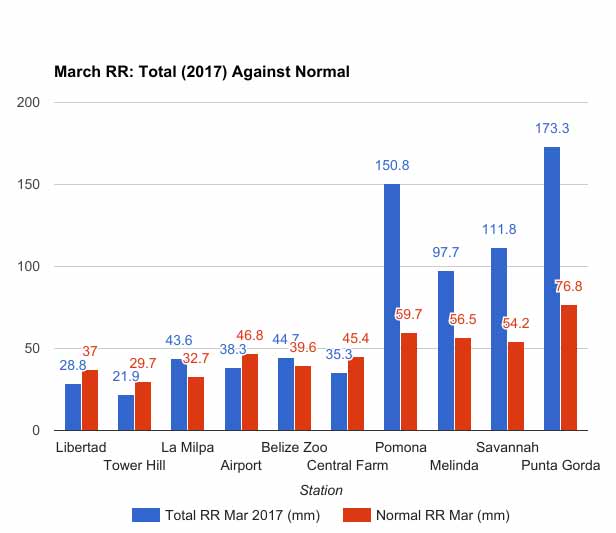
As mentioned throughout the discussion, most of the rainfall activity occurred over southern areas of the country. Resulting comparisons of total rainfall in March, 2017 against normal rainfall for March, climatologically, (at some of the key weather stations set up across the country) are shown in the figure below.
|
|
|
|
|
Joined: Oct 1999
Posts: 84,398
|
|
OP
|
Monthly Weather Summary, April 2017
National Meteorological Service of Belize
April 2017 began typical with hot, hazy and dry weather as an East-Southeast airflow prevailed over the country from the 1st to the 5th. Only isolated thunderstoms developed mainly over the Maya Mountains and near the western border during the first few days of the month. As is customary in April the Atlantic High Pressure ridge dominated the region and heat lows developed over Mexico producing a tight pressure gradient resulting in gusty winds. By the 6th a light to moderate East-northeasterly flow developed due to high pressure ridges northwest and northeast of the country. On the 7th a cold front was over the Yucatan Peninsula which supported the east-northeast flow and a few showers over northern and western Belize. The east-northeast surface flow persisted on the 8th and isolated showers affected central and southern coastal areas during the morning then conditions returned to hot and dry by afternoon. Mainly fair and warm conditions continued on the 9th and 10th with isolated showers over northern areas on the 9th and over the south on the 10th.
A light to moderate east-northeast surface flow prevailed from the 11th to the 15th as the Atlantic Ridge extended into the Gulf of Mexico and a weak low pressure was north of Puerto Rico with troughing extended into the northeast Caribbean. On the 11th a few showers affected central portions of the country and offshore Dangriga in the afternoon. Moisture was high over the south on the 12th and a few showers developed south and over the Maya Mountains. On the 13th morning scattered showers were observed across the country then conditions became generally fair with a few showers mostly over central and southern areas. An increase in low level moisture on the 14th resulted in a few showers over the sea and in the north. On the 15th morning a few showers developed south then moved over central areas in the afternoon. Middlesex recorded 17.2mm of rainfall. By the 16th a slack pressure gradient was established between a broad ridge over the northwest Caribbean and a surface trough over the south central Caribbean resulting in a light easterly airflow.
The 17th started with a light to moderate easterly flow and a few morning showers across the country then by afternoon skies became increasingly cloudy as numerous thunderstorms developed over central and northern areas. At the PGIA intense thunderstorms and severe lightning were observed along with moderate to heavy showers. An upper level trough was over the Gulf of Mexico which produced a divergent pattern over the area. The evening sounding showed a moist and unstable atmosphere with precipitable water value 44.86 and K index of 29.9. The 18th to the 20th a few showers and isolated thunderstorms continued to affect mostly coastal and southern parts of the country in the morning and the Maya Mountains in the afternoon due to daytime heating. On the 18th San Pedro recorded 36.1mm of rainfall while Dangriga received 25.3mm. The 19th saw a decrease in showers in the evening but during the night showers, light rain, isolated thunderstorms and gusty winds affected northern and coastal areas as an upper level low over the Bay of Campeche shifted eastward and a diffluent pattern was over northern Belize. Showers continued on the 20th with Belmopan recording rainfall of 55.6mm, Belize City 44.5mm and PGIA 36.8mm. By evening moisture and instability decreased, and Tropical Storm Arlene, the first tropical storm of the Atlantic hurricane season formed over the Atlantic.
The 21st was mostly fair and dry as a slack pressure gradient over the area kept winds light. Tropical Storm Arlene remained over open waters and was eventually absorbed by an extra-tropical low pressure system losing its tropical characteristics. On the 22nd a light east-southeast airflow prevailed producing fairly warm conditions. Isolated thunderstorms developed inland due to intense daytime heating and moved over Biscayne Village producing a freak storm or tornadic type phenomenon. Local reports suggest about eight homes were damaged. On the 23rd winds were light and from the north-northwest due to ridging west and northwest of the country. As a result temperatures were relatively mild. The 24th started with a north-northwest flow but during the daytime winds shifted to the southeast as thermal troughs developed over Mexico.
The last week of the month seasonably warm, hazy and dry conditions resumed over the country as the Atlantic High Pressure ridge dominated. On the 25th weak ridging over the northwest Caribbean and a broad trough over the western Gulf of Mexico with axis along eastern Mexico maintained a light east-southeast airflow. A cold front dissipated over the extreme northwest Caribbean and northern Yucatan. From the 26th to the 27th thermal troughs over Mexico and the Atlantic ridge supported a moderate east-southeast airflow that became strong and gusty from the 28th to the 30th as the pressure gradient tightened. These strong winds produced rough sea conditions and as a result small craft warnings were issued.
|
|
|
|
|
Joined: Oct 1999
Posts: 84,398
|
|
OP
|
Monthly Rainfall Summary, May 2017
National Meteorological Service of Belize
The rainfall summary for May 2017 shows that with the exception of Rio Bravo and Tower Hill located over the northwestern Orange Walk districts, most areas of the country recorded below normal rainfall for the month. Areas with driest conditions were central coastal areas. That is coastal Belize and Stann Creek Districts. The deficit in rainfall was likely due to a slow start of the rainy season which normally commences in mid to late May over the south and gradually make its way north by the end of May into Early June. The maps below show the total rainfall recorded at some key stations and how that total compares to the normal for the month of April. A similar comparison is shown by the bar graph that compares the recorded total for May 2017 againt the climatological norm for the month.

|
|
|
|
|
Joined: Oct 1999
Posts: 84,398
|
|
OP
|
Monthly Weather Summary, May 2017
National Meteorological Service of Belize
THE MONTH OF MAY STARTED WITH MAINLY FAIR, WARM AND DRY WEATHER WITH AN EAST TO SOUTHEASTERLY SURFACE FLOW OVER BELIZE AS THE NORTH ATLANTIC HIGH PRESSURE RIDGE EXTENDED INTO THE NORTHWEST CARIBBEAN AND DOMINATED THE AREA. RIDGING WAS NOTED AT THE UPPER LEVELS FOR THE FIRST THREE DAYS WITH RELATIVELY LOW AMOUNTS OF MOISTURE, RESULTING IN ONLY ISOLATED SHOWERS OVER THE COUNTRY. A COLD FRONT WAS LOCATED IN THE CENTRAL GULF OF MEXICO THAT PREGRESSED EASTWARD. AS THE COLD FRONT APPROACHED THE AREA, CONDITIONS BECAME MORE FAVORABLE FOR SHOWERY ACTIVITY AS MOISTURE AND INSTABILITY INCREASED OVER THE AREA. ON MAY 4TH, INTENSE THUNDERSTORMS DEVELOPED OVER THE MAYA MOUNTAINS LASTING FOR OVER TWO HOURS AND PROGRESSED ON A SOUTHWESTWARD PATH BEFORE DISSIPATING LEAVING BEHIND DENSE CIRRUS CLOUDS STREAMING OVER THE AREA. CLOUDINESS AND MOISTURE INCREASED OVER THE AREA DUE TO THE COLD FRONT LOCATED OVER LOUSIANNA AND EXTENDING DOWN INTO THE BAY OF CAMPECHE. A FEW SHOWERS AND THUDERSTORMS OCCURED ON MAY 5TH OVER THE CENTRAL AND NORTHERN AREAS OF THE COUNTRY ASSOCIATED WITH A PRE-FRONTAL TROUGH TO THE EAST OF BELIZE SUPPORTED BY AN INCREASE IN MOISTURE LEVELS OVER THE AREA WITH THE LATEST PWAT VALUE BETWEEN 55-60MM AND A DIVERGENT UPPER LEVELS DUE TO AN UPPERL LEVEL TROUGH OVER THE COUNTRY. A NORTH TO NORTHWESTERLY AIRFLOW PREVAILED OVER THE AREA AND SHOWERS AND THUNDERSTROMS SPREAD TO MOST AREAS AS THE COLD FRONT CROSSED THE COUNTRY OVERNIGHT AND REMAINED STATIONARY OVER THE GULF OF HONDURAS AND SOUTHERN BELIZE. WEATHER CONDTIONS IMPROVED OVER THE COUNTRY OF MAY 7TH AS THE UPPER LEVELS WERE CONVERGENT, MOISTURE LEVELS DECREASED AND RIDGING DOMINATED THE AREA RESULTING IN SUBSIDENCE AND SUPPRESSION OF CONVECTION.
SIMILAR WEATHER CONDITIONS PREVAILED OVER THE COUNTRY FROM THE 8TH TO THE 11TH OF MAY WITH A RIDGE AT THE UPPER LEVELS IN A CONVERGENT PATTERN IN DRY LOW LEVEL CONDITIONS IN AN EAST TO NORTHEASTERLY AIRFLOW VEERING TO THE SOUTHEAST. ONLY ISOLATED SHOWERS WERE OBSERVED OVER THE COUNTRY DURING THIS PERIOD. THIS DRY SPELL WAS INTERUPTED BY A LATE SEASON COLD FRONT WHICH RESULTED IN ANOTHER INCREASE AND CLOUDINESS AND MOISTURE OVER THE COUNTRY FROM THE SURFACE THROUGH TO THE MID-UPPER LEVELS. CONDITIONS BECAME WEAKLY DIVERGENT AT THE UPPER LEVELS AND A FEW SHOWERS AND THUNDERSTORMS DEVELOPED OVER THE MOUNTAINS AND SOUTHEAST BENQUE VIEJO ON MAY 12TH AND OVER CENTRAL AND INLAND AREAS ON THE 13TH WITH VERY INTENSE THUNDERSTORM ACITIVITY (YELLOW BAND) DETECTED ON RADAR IMAGERY. SHOWERY ACTIVITY INCREASED OVER THE COUNTRY ON THE 14TH AND 15TH WITH SOME SHOWERS, PERIODS OF RAIN AND A FEW THUNDERSTORMS OBSERVED OVER MOST AREAS. THIS ACTIVITY WAS FURTHER ENHANCED BY A TROUGH OVER THE YUCATAN PENNINSULA, A COLD FRONT EXTENDING INTO THE BAY OF CAMPECHE AND A BROAD AREA OF LOW PRESSURE WHICH DOMINATED CENTRAL AMERICA AND THE WESTERN CARIBBEAN. A LIGHT WEST TO NORTHWESTERLY AIRFLOW PREVAILED OVER THE AREA. RECORD LEVELS OF PRECIPITATION WERE OBSERVED ON THE 15TH OVER THE NORTH AND SOUTHEAST COAST WITH HIGHEST RAINFALL VALUES RECORDED IN ORANGE WALK (54.4MM), TOLEDO (33.4MM) AND COROZAL (26.4MM).
SKIES BECAME PARTLY CLOUDY TO CLEAR AS THE ATMOSPHERE BECAME DRIER AND MORE STABLE OVER BELIZE. IN SURROUNDING REGIONS LIKE THE YUCATAN AND THE NORTHWEST CARIBBEAN, TROUGHING WAS OBSERVED AT THE LOW AND UPPER LEVELS WHILE A DEEP RIDGE WAS OVER MEXICO AND BELIZE. HOWEVER, THE NORTH ATLANTIC HIGH PRESSURE RIDGE WAS THE DOMINANT FEATHER OVER THE AREA AS IT EXTENDED INTO THE NORTHWEST CARIBBEAN. THEREFORE, SHOWERS WERE ISOLATED EXCEPT FOR A THUNDERSTORM THAT OCCURED OVER THE WESTERN BORDER AND OVER GUATEMALA ON THE AFTERNOON OF THE 18TH AND 20TH. THE WINDS AT THE UPPER LEVEL HAD A WEST TO NORTHWESTERLY COMPONENT DUE TO THE UPPER LEVEL TROUGH TO THE EAST OF BELIZE, WHILE AT THE SURFACE, A LIGHT EASTERLY AIRFLOW PREVAILED. ON THE 21ST AND 22ND, A FEW PASSHING SHOWERS AND ISOLATED THUNDERSTORMS OCCURED OVER THE NORTHERN AND INLAND PORTIONS OF THE COUNTRY AT FIRST, THEN OVER CENTRAL AND SOUTHERN AREAS AS A RESULT OF A TROUGH LOCATED IN THE BAY OF CAMPECHE AND RESULTING INCREASES IN UPPER LEVEL MOISTURE AND PWAT NEAR BELIZE. THE SURFACE WINDS BECAME A BIT GUSTY WITH AN EASTERLY AIRFLOW DURING THESE DAYS.
AS THE MONTH NEARED ITS END, CONDITIONS BECAME FAIR, DRY AND HOT OVER THE COUNTRY WITH RIDGING OVER THE CARIBBEAN AND A MODERATE EAST TO SOUTHEASTLY FLOW. SHOWERS WERE ISOLATED OVER INLAND AREAS DUE TO DAY TIME HEATING. ANOTHER LATE SEASON COLD FRONT WAS LOCATED IN THE CENTRAL GULF OF MEXICO AND THE BAY OF CAMPECHE ON THE 24TH WHICH RESULTED IN CONDITIONS BECOMING CLOUDY AND MORE UNSTABLE OVER THE REGION. STRONG COVECTIVE ACTIVITY WAS AHEAD OF THE COLD FROM THAT RESULTED IN STRONG THUNDERSTORM ACTIVITY OVER THE INLAND AREAS OF BELMOPAN, SPANISH LOOKOUT AND BENQUE VIEJO RESULTING IN STRONG WINDS OF 37 AND 39 KNOTS IN BELMOPAN AND BALDY BEACON AND 16MM OF RAINFALL. A TROPICAL WAVE WAS ALSO LOCATED 87 W SOUTH OF 18N WHILE THE UPPER LEVEL PATTERN WAS DIVERGENT AND CONVERGENT AT THE LOW LEVELS.
|
|
|
|
S |
M |
T |
W |
T |
F |
S |
|
|
1
|
2
|
3
|
4
|
5
|
6
|
|
7
|
8
|
9
|
10
|
11
|
12
|
13
|
|
14
|
15
|
16
|
17
|
18
|
19
|
20
|
|
21
|
22
|
23
|
24
|
25
|
26
|
27
|
|
28
|
29
|
30
|
|
|
|
|
|
|
0 members (),
160
guests, and
0
robots. |
|
Key:
Admin,
Global Mod,
Mod
|
|
|
Forums44
Topics79,205
Posts500,031
Members20,471
| |
Most Online7,413
Nov 7th, 2021
|
|
|
|


