 Belize is located near the junction of the North American and Caribbean tectonic plates, slabs of the earth's crust that have moved past each other over the last 80 million years. Eastward drift of the Caribbean plate resulted in the dominantly structurally-controlled, major features of Belize: the Maya Mts., offshore atolls surrounded by deep water, and the location of the coral barrier reef.
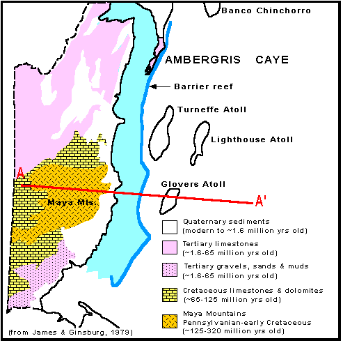
The Maya Mountains are the high, rugged core of Belize, composed of igneous, metamorphic, and sedimentary rocks that are from 125-320 million years old. The surrounding flat plains are underlain by Cretaceous and Tertiary rocks (1.6-65 million years old), largely limestones, that indicate that Belize was covered by a warm, shallow sea during this long period of time. The Quaternary (Pleistocene) rocks and modern sediments along the coast, and under water, are the youngest cycle of deposition in Belize, and are represented largely by shallow-water, limy sediments. 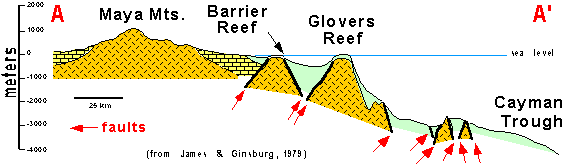 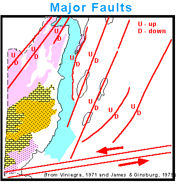
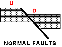
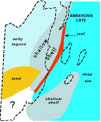
Along its entire length the modern barrier reef sits atop a prominent fault that separates the shallow platform to the west from the deeper Caribbean to the east, where water depths progressively approach 4000 meters. Turneffe, Lighthouse and Glovers Atolls all sit atop major fault blocks ("horsts") that formed as a result of the eastward sliding of the Caribbean plate past Belize and the North American plate. The major NE-trending faults shown in the accompanying map are "normal faults" that include portions that have dropped down on their eastern sides. The nearly EW-trending fault on the south is the boundary of the North American and Caribbean plates. |
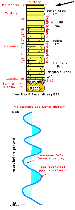
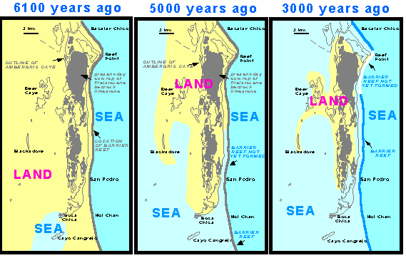
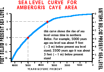
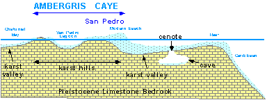
The Gulf Oil #1 Basil Jones well, drilled on Ambergris Caye, includes nearly 2500 meters of rocks that tell the geologic story of the caye. From about 300-130 million years ago the caye was exposed land connected to mainland Belize. From 130 to about 1.6 million years ago, the caye was mostly covered by a shallow sea much like that of today. The map on the right shows what Belize looked like about 100 million years ago, during the Cretaceous Period. At that time Ambergris Caye, and most of Belize, were covered by a shallow sea, with the Maya Mts. Exposed as a large landmass. The shallow south end of Glovers Atoll eventually subsided into the Caribbean as the plates moved past each other. Ambergris Caye did not exist then as we know it today. Its foundation of Cretaceous and Tertiary limestones formed from the accumulation of shells and reef debris like those being deposited today. Glaciers alternately advanced and retreated across the continents during the Pleistocene Period, from 1.6 million to 10,000 years ago. As they advanced and ice built up, global sea level dropped and exposed the limestones on the caye to rainwater, which resulted in the formation of ther many caves and sinkholes (cenotes) on the caye and throughout Belize. These features are known as "karst". As the glaciers retreated global sea level rose and new limestones were formed. Four sea level falls and rises are recorded by the Pleistocene limestones on and under Ambergris Caye. The youngest limestones on the caye, such as at Reef (Rocky) Point, are 125,000 years old and they were exposed on land until about 6100 years ago when sea level began to rise again to its present stand. These rocks also have karst features.
Click Below for information on the geologic origins of Ambergris Caye, a study by Dr. Sal Mazzullo The paper above is an expose of the geological evolution of northern Belize from about 3.5 million years ago to now. In summary, the finding suggest that the area was a sloping shelf some 3.5 millin years ago, and the site of Ambergris s Caye was in relatively deep water. The area was faulted about 1.8 million years ago as sea level fell, exposing the older shelf, and the consequence of that was the creation of a high ridge along the shelf edge that became the site of coral growth. From them until now, the area has been the site of shallow water reef and associated lime deposition. The whole area was affected by at least 4 sea-level drops in the last 1.8 million years, the last one (about 18,000 years ago) which resulted in formation of caves and allied karst features in northern ffshore Belize and the creation of what is now Ambergris Caye.

Prepared by Dr. S. J. Mazzullo Department of Geology Wichita State University |

Copyright by Casado Internet Group, Belize |