Belize Weather Forecast: October 3, 2021


 General Situation:
Ambergris Caye: Conditions this morning by Elbert just before or after this post!
Belize NMS:
Present Condition: Mostly clear skies this morning, a few scattered clouds, expecially in the Chiquibul area. Mostly clear in San Pedro. Generally fair weather prevails.
Advisories: None.
24-hour forecast:
Sunny with cloudy spells today and partly cloudy skies tonight. Showers or thunderstorms will be isolated, except for a possible few more along the coast and over the north this morning.
Winds: E-NE, 5-10 kts
Sea State:
Slight
Waves: 1-3 ft
Sea Surface Temperature (°f): 87
Outlook:
For Monday and Monday night is for a similar trend.
Sargassum Forecast from September 28 to October 6:
There is a medium chance of sargassum affecting beaches, especially over northern Belize, during the next few days. San Pedro has a medium probability and a moderate impact.
Tropical Weather Outlook:
At 3:00am, Tropical Depression Victor was located near latitude 16.1N, longitude 39.9W, or about 1055 miles west of the Cabo Verde Islands. - At 3:00am, Hurricane Sam was centered near latitude 37.3N, longitude 55.9W, or about 665 miles SSW of Cape Race Newfoundland.
Click for more of the tropical weather outlook...
Marine Conditions:

The Caribbean Sea
There is one tropical wave in the Atlantic, and one in the Caribbean.
An upper-level trough extends from the NW Bahamas to central Cuba
to Nicaragua. Showers and tstorms are being enhanced along and to
the east of the upper-level trough axis. Scattered moderate and
isolated strong thunderstorms cover the north-central Caribbean,
north of 15.5N between 69W-81W. Strong convection is seen in the
south-central to SW Caribbean south of 13N between 70W-80W.
Overnight ASCAT data show fresh trades in the eastern and central
Caribbean, mainly south of 17.5N and east of 77W, where seas are
4 to 6 ft. Moderate trades prevail across most other areas, where
seas are 2 to 4 ft. NOAA buoy 42060, located near 16.4N 63.3W has
recently reported 19 kt winds and 6 ft seas. Earlier altimeter
data from Saturday afternoon showed seas of about 5 feet from 14N-
17N between 67W-69W.
High pressure along the mid Atlc coast along 34N will produce
fresh tradewinds from the central Caribbean to the tropical N
Atlantic today and persist across the Caribbean through Tue.
Winds and seas will become fresh to strong across the central
Caribbean Mon and Tue as the high pressure moves slowly eastward.
Moderate N to NE swell will affect the tropical Atlc waters
through Tue.
| |
High |
Low |
| Coastal |
31° C
88° F
|
26° C
79° F
|
| Inland |
34° C
93° F
|
22° C
72° F
|
| Hills |
28° C
82° F
|
20° C
68° F
|
| TIDES: |
|
| High: 7:26 AM |
Low: 2:25 PM |
| High: 8:30 PM |
Low: 2:05 AM (Mon) |
| Sunrise: 5:43 AM |
Moonset: 4:02 PM |
| Sunset: 5:39 PM |
Moonrise: 3:56 AM (Mon) |

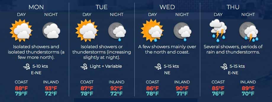
Four Day Weather Outlook:
For more information, check the Daily Tropical Weather Outlook.
Climate Prediction Center's Central America Hazards Outlook
Belize National Emergency Management Organization (NEMO)
Ambergris Caye:
https://www.wunderground.com/weather/bz/san-pedro
Philip S W Goldson International Airport:
https://www.wunderground.com/weather/bz/belize/MZBZ?cm_ven=localwx_today
Belmopan:
https://www.wunderground.com/weather/bz/belmopan/17.26%2C-88.78
Caye Caulker:
https://www.wunderground.com/weather/bz/caye-caulker-village


|


