TROPICAL CYCLONE 13 IN THE SOUTH-CENTRAL CARIBBEAN TAKING AIM AT THE WESTERN CARIBBEAN REGION AND BELIZE
As at 1:00PM, THURSDAY, 6TH OCTOBER 2022
The National Meteorological Service of Belize and the National Emergency Management
Organization (NEMO) hereby inform the general public that potential tropical cyclone 13 with
winds of 35 mph is located near 11.5 North Latitude and 67.7 West Longitude or just north of
Venezuela and is moving westward at 15 miles per hour. The pressure is 1005 millibars. The
system is likely to make landfall in Nicaragua and Honduras. It is expected to weaken rapidly as
it moves over mountainous terrain. In that scenario, strong winds should not affect Belize. It will
likely be heavy rainfall and flooding especially in southern Belize. A potential worse case, but a
less likely scenario, is the centre could move more to the north of the forecasted track. If that
occurs, we could be dealing with a hurricane which would make landfall on Belize on Monday.
The system is expected to strengthen when it moves over the southwestern Caribbean Sea. By
Friday it is expected to be south of Haiti, by Saturday it is expected to be south of Jamaica, by
Sunday morning it is expected to be over Nicaragua and Honduras, and by Monday it is likely to
be in front of or over Belize. Rainfall amounts is likely to peak on Monday with daily totals of
about 4 to 6 inches or higher. Rain is expected before the system reaches our region so flooding
could occur before it makes landfall.
1. Review your family/emergency plan, check on the elderly and people with disabilities.
2. Out district travel for the long weekend is not advised if it is not necessary.
3. Fishers are asked to remain in port. Always keep handy a commercial AM/FM radio, and cell phone
to monitor weather conditions. Before leaving home secure your pets and important documents.
4. If your home is likely to flood, before leaving home turn off the main electrical switch and water valves.
5. Clean drains, and trim trees which can fall and damage your home.
6. Boil or purify water in flooded areas before drinking it. Ensure you have your emergency kit with
flashlight, medicines etc.
7. If you live near to a river, creek, and low-lying area take the necessary actions to save life.
8. Avoid walking or driving through flood waters. Six inches of running water can knock you down and
one foot of water can sweep your vehicle away.
9. Drive slowly and put on your hazard lights when driving in the rain.
Move to safety (high grounds) early, do not wait until it's too late, always move before nightfall.
NEMO's emergency hotline is 936. Stay alert, be prepared. Take these advisories seriously.
NEMO is on full alert, all national city and district committees including the Red Cross are meeting
today and tomorrow.
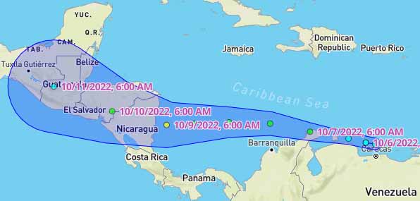
At 3:00am, Tropical Depression Thirteen was located near Lat 12.1N and Long 71.1W or about 35 miles southeast of Northern tip of Guajira Peninsula Colombia. TD Thirteen was moving west at 15mph with Max sustained winds of 35mph. This system has the potential to produce heavy rainfall and possible flooding over Belize on Sunday into Monday, and therefore the National Meteorological Service of Belize will continue to monitor this system very closely.
For further information on tropical conditions, check the daily Tropical Weather Outlook, click here.
At 9:00am, newly formed Tropical Storm Julia was centered near Lat 12.7N and Long 73.1W or about 110 miles west of Northern tip of Guajira Peninsula Colombia. Julia was moving west at 18mph with Max sustained winds of 40mph. This system has the potential to produce heavy rainfall and possible flooding over Belize on Sunday into Monday, and therefore the National Meteorological Service of Belize will continue to monitor this system very closely.
Accuweather: Beyond early next week, the zone from the southern Gulf of Mexico through the western and central Caribbean Sea may remain a tropical trouble spot. A front is forecast to dip into the region and stall. While this may generate disruptive wind shear, it may also help generate more spin in the region that could allow a new tropical system to take shape. Because of this, the region will remain under the watchful eye of AccuWeather meteorologists.
Advisory #2: Tropical Storm Julia
As of 4:00 pm, Friday, 7th OCTOBER 2022
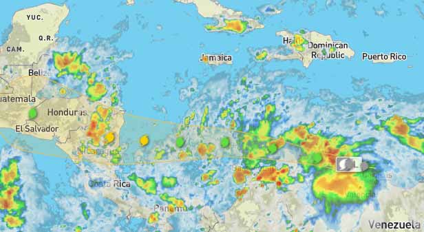
Tropical Storm Julia as of 4:00 pm local time was located near latitude 13.0N, longitude 74.7W or about 450 miles east of La Providencia, Colombia. Julia was moving to the west at 18mph with maximum sustained winds of 40 miles per hour and minimum central pressure of 1002 millibars. A generally westward motion is expected to continue through Sunday morning until the system makes landfall in Nicaragua as a category one hurricane. Rapid weakening is expected after landfall with the system becoming a remnant low by Sunday night into Monday morning. Direct landfall from this system is not expected in Belize and hence tropical storm or hurricane conditions are unlikely to affect Belize. However, the system will be a heavy rainfall producer (showers and thunderstorms), which could lead to widespread flooding across the country, especially over the south.
A moist north-easterly airflow ahead of this system is supporting rainfall across the country with totals of one to two inches expected today Friday; another one to two inches on Saturday, three to five inches on Sunday and Monday, and then decreasing to one to two inches on Tuesday as the remnants of the system moves away. Note that these are model estimates and we may experience higher amounts. Squally conditions and moderate to rough seas are expected. The worst- case scenario of direct landfall in Belize is not likely as the models are tightly clustered on a westward motion towards Nicaragua. It now appears that the west- north-westward turn after landfall will not be sufficient to have the centre re- emerge over the Gulf of Honduras.
NEMO advises the public to remain vigilant throughout the long weekend. The weather conditions over the weekend may lead to flooding in low-lying areas. Check your family/emergency plan and check on vulnerable family members, particularly the elderly and persons with disabilities. Be prepared to take the necessary actions to save lives. If you must evacuate, go to higher grounds, do not wait until it is too late and always move before nightfall. Avoid walking or driving through flood waters. Six inches of running water can knock you off your feet. One foot of water can sweep your vehicle away. Drive slowly and put on your hazard lights if you must drive in the rain.
NEMO's emergency hotline is 936. Stay alert and be prepared.
========================
TS Julia Barreling Towards Nicaragua
Last night the weather system tracking across the southern Caribbean Sea was being called "Potential Tropical Cyclone 13"; tonight it's Tropical Storm Julia with maximum sustained winds of 40 miles and hour, and moving west at 18 miles per hour, heading straight for Nicaragua.
That general path is forecast to continue, and it is expected to strengthen into a category one hurricane before it makes landfall in Nicaragua by Sunday morning.
So, what does that mean for the weather in Belize during this Holiday weekend? In a Zoom press briefing this afternoon, the Chief Meteorologist said that citizens should expect heavy rain as the storm's outer bands get closer:
Ronald Gordon - Chief Meteorologist "The system is now Tropical Storm Julia which, as of 3 p.m. local time, was centered near latitude 13.0 degrees north, 74.7 degrees west, moving to the west at 18 miles per hour with maximum sustained winds of 40 miles per hour. The forecast is for Julia to continue on a westward track and to make landfall on Nicaragua early on Sunday morning as a category one hurricane. On that note, the system, after making landfall, will move further inland into Nicaragua and Honduras and dissipate over those mountainous terrains. The remnants of Julia, however, will continue moving westward, and the outer bands will move across Belize, producing torrential rainfall into the weekend. We are already experiencing moisture from a moist north-easterly airflow ahead of this system which, of course, will cause our soils to become more saturated. And then, with the rainfall that we expect from the system as it - the remnants of it - moves south of us will basically cause the flooding situation to be worse. In terms of totals, we're expecting about 1 to 2 inches of rainfall today and then tomorrow, not from that system directly, but from the moist northeasterly airflow that I spoke about. And then, when the bands from the system moves across, we can see up to 3 to 5 inches maximum on Sunday and Monday and then decrease on Tuesday as the system moves further west. So again, the main threat from this system will be rainfall and potential flooding. Those will also include flash flooding over the areas in the south and possible landslides. In terms of winds, on Saturday night into Sunday, we're expecting winds of about 15 to 25 knots, with higher gusts near showers and thunderstorms. Those, of course, could cause significant hazards for mariners, especially those operating small vessels. So, of course, we are likely to issue a warning for Mariners during those days. But apart from that, we're not expecting tropical-storm-force winds sustained across the country. The highest probability, and the most likely scenario, is that it will not make landfall on Belize. There is a minute chance that the system emerges on the gulf of Honduras, but that is fading rapidly. If you look at the latest projections, the latest cones of uncertainty coming out from the National Hurricane Center, Belize is not included anymore. So, the most likely scenario is for the system to make landfall on Nicaragua and for its remnants to move across Central America and rapidly weaken. You have some very rugged mountainous terrain, and tropical systems don't survive that type of environment. So, the system is likely not going to emerge into the Gulf of Honduras and make any direct landfall on this country."
MET Says Stay At Home This Weekend
The National Hydrological Service has released its flood bulletin ahead of the weekend's stormy weather from Tropical Storm Julia.
They say the New River in northern Belize is near the flood stage. On the Sibun River at Freetown Sibun and on the Southern Lagoon Near Gales Point, Manatee flood stage levels are expected.
With the rains this weekend, the Belize River at Double run is expected to increase to the flood stage. On The Crooked Tree Lagoon, flood levels are expected to exceed the spillway. Flood-stage levels are also expected on the Mopan River at Benque Viejo Town. On the Macal River at all BECOL facilities, there is the possibility of levels exceeding the spillway. In San Ignacio, there is a high possibility that the low-level bridge will become inundated.
So, while the forecasts say that Belize won't be hit directly by a tropical storm or a hurricane, Julia's outer bands will dump a lot of rain all over the country. So, if you had prior plans for your 3-day weekend, the Chief Meteorologist is advising that you stay at home instead and ensure your safety:
Ronald Gordon - Chief Meteorologist "I certainly would advise people not to do that. It's bad weather, and you don't want to be on the roads during heavy rainfall. You don't want to be on the seas during heavy thunderstorms and rough seas. So, it would be inadvisable to go about your merry way and make those types of preparation or do that type of activity. It's best to remain at home safe. The roads can be treacherous during bad weather. So, my advice for persons is to stay home this weekend. But again, there is no mandatory - as far as I'm aware, there is no run out there mandating that persons cannot travel. But we can only advise. The weather is going to be bad. We're not gonna direct landfall from a hurricane or a tropical storm, but it's going to be bad weather. So, the wise thing to do is to remain in a shelter, to remain at home, where you are safe."
Flooding and The King Tide Consequence
The expected flooding for Belize City this weekend will likely be exacerbated by the exceptionally high tides for this time of the year, which are often referred to as "King Tides."
So, citizens in the city's flood-prone areas will have to keep a close watch on the water levels on their streets and in their yards. Here's what the Chief Met Officer had to say when we asked about the compounding effect of those "King Tides" and the full moon this weekend:
Jules Vasquez "Is the arrival of the "King Tide" and the full moon an additional concern that people have to be aware of with this heavy rain and flooding that is expected with this storm?"
Ronald Gordon - Chief Meteorologist "I will agree with you 100%. Yes, indeed, if the system is arriving, and as I said, with all the rainfall that we expect, and you combine all those factors with the high tides and the fact that the City is already low, relatively speaking, then, of course, it will sort of make the flooding situation worse, especially over Belize City. So, that is indeed a concern that persons should be aware of and be prepared for."
In other news about the expected weekend flooding, the Ministry of Agriculture, Food Security, and Enterprise advises farmers in low-lying or flood-prone areas to try their best to secure their agriculture and livestock investments.
For livestock producers, the Ministry advises them to relocate their animals to safer areas temporarily, ensure animal feed and water availability, count all animals, secure all farm machinery and farm input, and relocate all pesticides and pesticide containers to avoid spillage and contamination.
Tropical Storm Julia Heads to Land Tropical Storm Julia heads to land, and will impact Honduras, Nicaragua... and even parts of Belize and Mexico. Most of the bad weather should stay north of Costa Rica.
Julia could become a hurricane right before making landfall on Sunday. Mudslides are a threat even in Guatemala and El Salvador.
=====================
Tropical Storm Julia Barrels West Towards Nicaragua
Brace yourself for the effects of Tropical Storm Julia. The weather system is expected to make landfall in Nicaragua on Sunday morning, as a category one hurricane. TS 13 is barrelling along a westward trajectory at sustained winds of forty miles per hour and moving at a speed of eighteen miles per hour. Rapid weakening is expected after landfall with the system becoming a remnant low by Sunday night into Monday morning. Ahead of the weekend, the media got an update from Chief Meteorologist Ronald Gordon on the approaching weather.
Ronald Gordon, Chief Meteorologist
"The forecast is for Julia to continue on a westward track and to make landfall on Nicaragua early on Sunday morning as a category one hurricane. On that note, the system after making landfall will move farther inland into Nicaragua and Honduras and dissipate over those mountainous terrains. The remnants of Julia will continue moving westward and the outer bands will move across Belize producing torrential rainfall into the weekend. We are already experiencing moisture from a north-easterly airflow ahead of this system which of course will cause ourselves to become more saturated and then with the rainfall that we expect from the system as the remnants move over us will basically cause the flooding situation to be worse. The main threat from this system will be rainfall and the potential flooding. Those will also include flash flooding over areas of the south and possible landslides. In terms of winds, on Saturday night into Sunday, we are expecting winds of about fifteen to twenty-five knots to higher gusts near showers and thunderstorms. Those could be significant hazard for mariners, especially those operating small vessels. So we are likely to issue a warning for mariners during those days. But apart from that, we are not expecting tropical storm force winds sustained across the country."
At 3:00am, Tropical Storm Julia was centered near Lat 12.7N Long 78.0W or about 235 miles east-southeast of Isla de Providencia, Colombia. Julia was moving to the west at 18 mph with maximum sustained winds of 60 mph. This system is expected to produce heavy rainfall and possible flooding over Belize on Sunday into Monday, and therefore the National Meteorological Service of Belize continues to monitor it very closely.
Boat owners are advised that heavy rains will occur over the weekend (October 8th and 9th), especially at night. Vessels could sink as a result. Please monitor your vessels closely and secure.
For further information on tropical conditions, check the daily Tropical Weather Outlook, click here.
Saturday October 8th. Latest forecast track is taking Julia further south. As a result dissipation over central America is becoming less likely. Looking like TS Julia will survive the trip across Nicaragua and enter the Pacific. Also speeding up with landfall on Nicaragua looking more like late tonight into early Sunday morning.
Threat to Belize remains the same. Heavy rainfall and flooding. Latest model forecast show about 2 to 4 inches today and about 4 to 6 inches tomorrow. Locally higher amounts are possible.
NEMO hotline: 936
For further information on tropical conditions, check the daily Tropical Weather Outlook, click here.
TROPICAL STORM JULIA has made a dip southwards, as I said, but still moving westwards. It is now getting closer and causing a lot of cloud. It has grown rapidly in size and is expected to develop into Cat.1 hurricane. The hurricane centre also show it dipping south as I have, but then changing to due west straight into central Nicaragua, but its outer bands of rain will certainly affect Belize, probably starting tomorrow.
For further information on tropical conditions, check the daily Tropical Weather Outlook, click here.
It has now been categorised as a hurricane HURRICANE JULIA but still on the same track.
The probable rain tonight is not from this storm, but other activity, but we are probably going to be getting rain on Sunday into Monday from its outer band.
Inland flash flooding are significant hazards for Central America as Julia moves inland and then crosses into the Pacific. Please be aware of the potential for this, even in Belize, despite the more southward track Julia is now taking. Please consult your local news, NEMO and the National Hurricane Center when making your travel decisions.
The NHC-MIAMI confirms that Hurricane Juli made a Nicaragua landfall across Laguna De Perlas with 85 mph winds at 2:55 AM Nicaragua time. The circulation of Hurricane Julia is over Central America.
For further information on tropical conditions, check the daily Tropical Weather Outlook, click here.
Hurricane Julia Makes Landfall with 85 MPH Winds Hurricane Julia makes landfall with winds of 85 mph, and gusts around 95 mph. It moved into the coast of Nicaragua early this morning. Life-threatening flash flooding is possible in parts of Nicaragua, Honduras, El Salvador, and Guatamala. Heavy rain will move into parts of Mexico. Most of the heavy rain stays south of Belize.
=======================
Storm Julia so far, has stayed to the south. We just Took the dogs out quick - the tide is high and the oceans churned up. As soon as we got inside it started pouring�that sideways rain. Photos by San Pedro Scoop
Good morning from beautiful Copal Tree Lodge in the Toledo District. Photo by Hopkins Uncut
There is some indications that this TROPICAL STORM JULIA might now track up closer to land than originally though, so possible it might continue to send rain our way more than originally expected.
FLOODING DUE TO HEAVY RAINFALL ASSOCIATED WITH THE REMNANTS OF HURRICANE JULIA OVER CENTRAL AMERICA
The National Meteorological Service of Belize and the National Emergency Management Organization (NEMO) hereby inform the public that heavy rainfall over Belize is associated with remnants of Hurricane Julia, which made landfall over Nicaragua on Sunday, 9th October 2022. Showers and thunderstorms associated with this activity are being monitored for possible tropical cyclone development, however, such development is not likely until the system emerges in the Gulf of Mexico.
Regardless of further development, the system will continue to produce heavy showers and thunderstorms across Belize. Maximum rainfall of 4 to 8 inches has been recorded across the country during the past 72 hours and another 2 to 4 inches is likely during the next 24 hours. This will increase the likelihood of flooding in the flood-prone areas of the country. Corozal and Orange Walk are under a flood watch. Belize City, Belize Rural, Cayo, Stann Creek and Toledo are under a flood warning. Additionally, a strong thunderstorm watch remains in effect for the possibility of strong thunderstorms with damaging winds and severe lightning. A small craft warning is also in effect due to gusty winds and rough sea conditions. Operators of small crafts are therefore advised to remain in safe harbour until the warning has been lifted. NEMO emergency operations centres countrywide will be opening shelters as needed.
NEMO continues to advise the public as follows: 1. If you live near a river, creek or low-lying area, take the necessary actions to save lives. Do not venture out to sea. 2. Check on the elderly and persons with disability. 3. If you need to seek shelter, move early. Do not wait until it is too late. Move before nightfall. Before leaving home, secure your documents and pets. 4. If your home is likely to flood, secure your home and turn off your electricity and water before leaving. 5. Avoid walking or driving through flood waters, turn back. Just six inches of moving water can knock you down and one foot of water can sweep your vehicle away. 6. Boil or purify water in flooded areas before drinking it. 7. Drive slowly and put on hazard lights if you must drive in the rain. As much as possible stay off the highways and secondary roads.
NEMO's emergency hotline is 936. Stay alert. Be prepared. NEMO is on full alert.
==================
Tropical depression Julia entered Guatemala and heads to the border with Chiapas.
The opinions and views expressed on this board are the subjective opinions of Ambergris Caye Message Board members and not of the Ambergris Caye Message Board its affiliates, or its employees.


![[Linked Image]](http://Ambergriscaye.com/art8/311441642_413484194277516_5376272382860252479_n.jpg)
![[Linked Image]](http://Ambergriscaye.com/art8/dfsdfdsfsd888999d7e.jpg)
![[Linked Image]](http://Ambergriscaye.com/art8/TropicalStormJulia.jpg)
![[Linked Image]](http://Ambergriscaye.com/art8/1022_julia-GEFS-oct7.jpg)
![[Linked Image]](http://Ambergriscaye.com/art8/311351103_414315720861030_736506480239754919_n.jpg)
![[Linked Image]](http://Ambergriscaye.com/art8/TropicalStormJulia2.jpg)
![[Linked Image]](http://Ambergriscaye.com/art8/310787551_411520581156288_3043850607256840918_n.jpg)
![[Linked Image]](http://Ambergriscaye.com/art8/dailywxB221008b.jpg)
![[Linked Image]](http://Ambergriscaye.com/art8/TropicalStormJulia3.jpg)
![[Linked Image]](http://Ambergriscaye.com/art8/C2dvF0n5cIswC6Tf-1.jpg)


![[Linked Image]](http://Ambergriscaye.com/art8/TropicalStormJulia4.jpg)
![[Linked Image]](http://Ambergriscaye.com/art8/085237_5day_cone_no_line_and_wind.jpg)
![[Linked Image]](http://Ambergriscaye.com/art8/310599921_701048191382930_8256398991533668816_n.jpg)
![[Linked Image]](http://Ambergriscaye.com/art8/310798128_701048201382929_6301538130786415153_n.jpg)
![[Linked Image]](http://Ambergriscaye.com/art8/311106257_701048181382931_541712130112918400_n.jpg)
![[Linked Image]](http://Ambergriscaye.com/art8/311178569_1832980513710347_2688400184868031555_n.jpg)


![[Linked Image]](http://Ambergriscaye.com/art8/311582627_3400252826922778_8650508006002976021_n.jpg)
![[Linked Image]](http://Ambergriscaye.com/art8/311521517_3400252986922762_2704835048519102067_n.jpg)


