
 Map: The Growth of Belize City from 1660-2020
The population of Belize City is at about 76,000 and the country about 400,000.
Based on historical aerial photos of Belize City, the attached graphic will show the extent of the growth of Belize City over the past 360 years. It will be interesting to see the extent of the growth of the city in the next fifty years. Will climate change inhibit growth, or will we continue to grow without regard for climate change?
Note: There was some development outside of these areas during the different periods; however, most of the development was within these areas during the specified periods. On the map there is a section named HOME Park. The name should be HONE Park named after a Colonial Secretary.
The Shoremen didn't live in the Belize settlement at the start. Two settlements were developed by the people from the Shore. The first was called Newtown. It was along the coast, west of the Belize settlement and there was a path linking these settlements. That area is now called Newtown Barracks. The second was called Convention Town. That settlement was northwest of Haulover on the Belize River.
According to St. John Robinson who undertook a study of Loyalists in the Caribbean and Central America, 2,650 persons had evacuated the Mosquito Shore by June 1787. Of that, 2,214 came to Belize. The arrivals included whites, 'coloureds', free blacks and slaves. The slave population was a combination of blacks, enslaved coloureds and indigenous people from Central America. The white and free people included William Bennett (father of Marshall Bennett), Andrew Cunningham, Robert English (namesake of Colonel English Bridge on the George Price Highway), Samuel Harrison, James Yarbrough, George Ra(y)burn (now spelt Rhaburn), Drury Smith, Ann Pattinett (now spelt Patnett), George Lovil (now Lovell), Absalom Bull, Seth Bird, Rutledge Nelson, Francis Hickey, Francis Haylock, Gerald Fitzgibbon, Harry Tonaston (now Tennison?), John Potts, John O'Brien, John Robinson and many others, including names like Moody, Maskall, Price, Gibb, Campbell, Perry, Graham, Young, Jeffries, Trapp, Hunt, Foster, Russell, Ferrell, Burke, Bode, Gladding, Longsworth, Goff, Caddle, Crawford, Neal, Harris, etc. Belisle, Usher, Wagner, Flowers, Stain, Broaster, Broster, Evans and Godfrey are also notable names on the list. Broaster is significant because These people were I believe James (not sure about the first name) and Eve Broaster. They are the ancestors of George Hyde one of the larger land and slave owners.
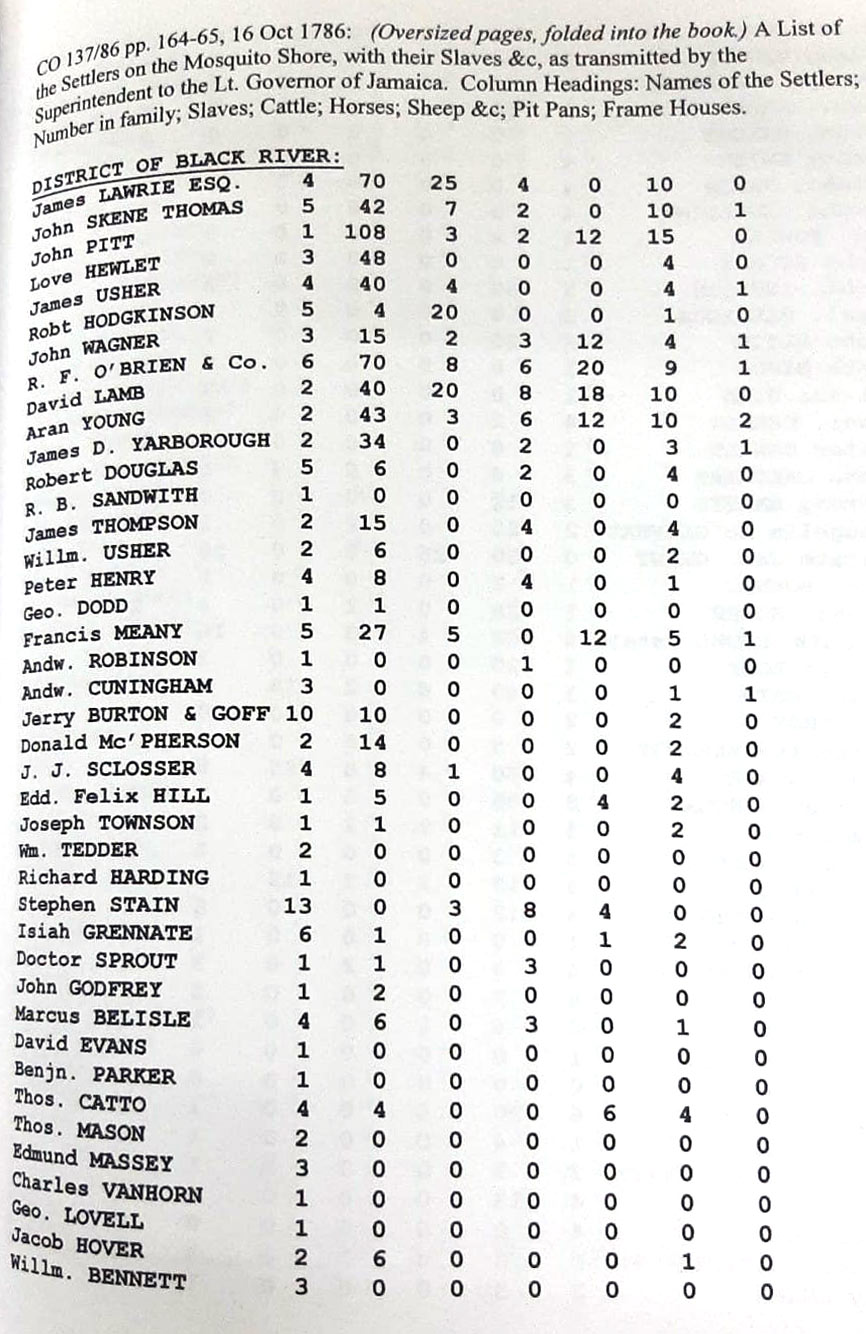
See image above: Both James and William Usher are on the list. They came from the District of Black River. James had 4 persons in his family in October 1786 and he owned 40 slaves, 4 cattle, 4 pit pans and 1 frame house on the Shore. William Usher had 2 in his family, plus 6 slaves and 2 pit pans.
John Broster also came from the Shore. He was listed as a tavern keeper on a bill of sale for some slaves in 1770 at the Shore.
We have finally identified where the first court house was located. From the map it seems to have been located where the Distributors building is across from where the Vogue used to be. The map also confirms where the second Anglican Church was built. The first being on St. George’s Caye. Was moved to Belize City after the 1779 attack. The second Church was built on Church Street where Heritage Bank is today. The third was the Cathedral where it is today. Barclay's Bank, now Heritage Bank is sitting on what was then first burial ground in Belize. When that area filled up, Yarborough gave space for what is now our Yabra Cemetery from his slave plantation.
Was not the earliest settlement by the mouth of the Belize River?... and then moved to the mouth of the Haulover creek after 1785 when the Spanish agreed to extend wood cutting to the Sibun? There are ruins in the high mangrove on North side of Haulover bridge. There are about TWELVE Maya mounds around Mile 11 on the Western Hightway, very visible from the Highway. I have been near to a few of them. These were Mayas who supplied the Mayas in the interior, with Sea Food, Salt and Sea Shells which were valuable Trinkets to the Chiefs or the Famous in the interior. In the 60s an old Jamaican lived on one nearest the road and sold mangoes. I think he was allowed to live there after the site was declared protected.
Hector Silva: CONVENTION TOWN. - There are areas between The George Price Highway, and the Belize Old River which were once settled -One is known as ALMOND HILL, -another POOR MAN RIDGE, yet another as NOGUERA PINE RIDGE. - across the river from the Airport. ALL HIGH LANDS which were recently flooded because of the LINK ROAD, which blocked the flow of water from PATTY POND to BURDEN CANAL. - This area is included in the studies made by the UN Team. -BETTER REFERED AS THE triangle. ( BELIZE CITY, BURREL BOOM -HATTIE VILLE ) - There is space to build many satellite towns to PORT BELIZE CITY. -
To continue reclaiming swamps around Belize is like building a SAMPAN City, with streets like those in VENICE. ( People do not like to hear this BUT Belize City is sinking - and the more CONCRETE placed on it the worse. - " BELIZE CITY IS SITTING ON AN ANCIENT RIVER DELTA, with pockets of PEAT up to 70 feet deep. - You can see one of them at Mile 4 of Haulover Road, where many buildings sank and more to come. -You can see at mile 5 on the Western Highway, which has been sinking from 1950, when Major Todd built that Road. As soon as the Link Road was being Constructed LAND started to be hunted worse than Gibnut. - I had a little piece of land there from 1984, where I was building a small farm with coconuts, Cashew and Mango trees, - SO I BEGAN TO GET BIG OFFERS but I and my partner said NO.
Recondev built Cinderella Town after the 1961 Hattie hurricane, and in 1965, when you drove along Princess Margaret Drive, you'd have thought you werevonnthe road to Corozal, all you saw was bush!
Kings Park did not exist, until they brought in a "sandpiper" to fill in was up to then just mangrove wetlands.
Going to SJC in 1972, you rode over a little wooden bridge, over the hump from the 12-inch diameter, black plastic pipe from the dredge, on Princess Margaret Drive, near what is now Said Musa's residence. The Drive was just gravel back then, not blacktop. Another route to SJC was the fastest route was on Freetown Road, which was paved, though you hit gravel on Princess Margaret Drive after you passed Pallotti. A more scenic route was by the sea, Princess Margaret Drive. In 1972 Radio Belize had an antenna adjacent to Pallotti on Princess Margaret Drive. Princess Margaret Drive itself, was unpaved and it comprised of red clay.
The Northside of the city has almost reach the end of its capacity to grow larger. I personally believes that the Southside would have grown to almost double its current size if this growth was not impeded by the mangrove swamps. These mangrove swamps are the reason why no Government will be able to eliminate the London Bridges. As the Government go in and build streets others will go into the swamps and build more houses and London Bridges. This process will also cause the city to expand with narrow streets.
It is a well known fact that Belize City is BELOW Sea Level. By the way, when Barclay's (Heritage) Bank was built, as did Fort George Hotel, the contractor drove PILES down 160 feet before it hit bedrock. Those two buildings are NOT floating. In contrast, when Pallotti Convent or High School was built, it was built on top a garbage dump and built to float. Some years later it began to sink lopsided. I believe engineers placed balloons underneath to keep it level, or something like that. Nowhere in Belize City is safe to build those large concrete buildings. sooner or later they will sink unevenly. I remember when Cinderella Town was mangrove as the site where technical College is built and everything North of there. I used to go and catch crab in the swamp there in August of each year. YES! Belize City is Built on swamp that once grew Mangrove and accommodate crabs holes.
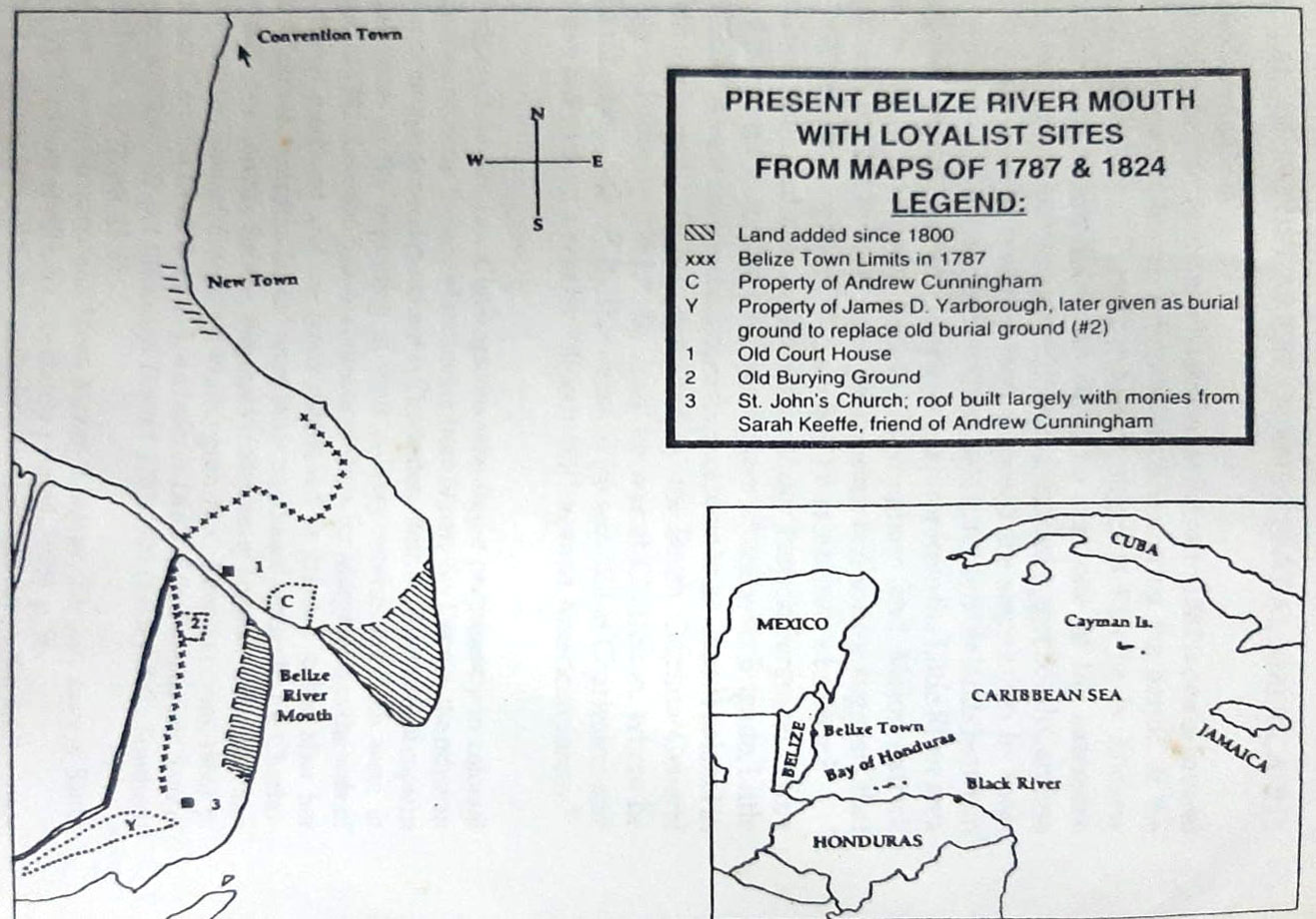
Here is a sketch showing where Newtown was and pointing in the direction of Convention Town. It shows the Belize Town limits in 1787 and several other interesting facts.
Hector Silva:
The beginning of the reclamation of King's Park ( Or "MAMMIE JEANIE" was in 1965. As the Minister of Public Works, from 1964 to 69, I was there to JUMP START this massive reclamation of Belize City.
The first thing we did was to remove the huge CONCRETE TARGET RANGE, and we placed two Dredges, The GIBNUT and the PECCARY about 1,000 feet North East from shore, on a submerge MOUND OF PIPE SHENK. Another place where there are Pipe Shenk is under the sea to the North of Stake Bank. Many of our old street were built with PIPE SHENK. (Dead Coral).
We filled the area 5 feet above the swamp to allow for final settlement of 3 feet. The same process we applied with the Queen's Square area. This KING'S PARK and QUEEN's SQUARE reclamation project was carried, between 1965 to 1969.
Then followed LAKE INDEPENDENCE. - part Dredge and part with clay from land.
In 1978-1980, BELAMA (Belize - Panama) on a joint venture did the large Haulover Area. (This is a brief report of this Massive Reclamation.) The Military Burial Ground was exactly where the Hon. Louis Sylvester House is located. When they were building his house, I am told that they found traces of this burial. After all, " New Town Barracks " was a Military Barracks. Their Radio was ZIK 2, administered by Lt Coronel D.N. A, Fairweather.
Bernadette Burns:
Belize City is a floating city,!!
Sounds strange?
Yes I know it does!!
These lands were swamp. B E C . Gave people their barks, Lumber strips, shavings and sawdusts to fill these lands. thousands of conchs shells and staghorn corals were dumped to created these land spaces. Then mud. That's why the buildings are cracking, leaning and swamping out.
Now please listen to me.
It's was for this same reason
Belmopan was designed so folks can easily Transition to solid safe grounds.
Yes climate change will effect the city. Yes Belize City will slowly sink. This little weather is proof of what is to come.
I am no scientist, But I am a critical thinker!!
Belize City is a pinicular. A piece of swampy land with moving waters on both sides, River and the Sea
We all know water shapes the land,
We have constant moving waters under the city.
Just think about what I am saying.
Belize City should have been established in Belmopan a long time ago.
No doom and gloom. Just facts,
Now you start to do your own thinking's.
THE TUG AND WAR BETWEEN MODERNIZATION OF BELIZE CITY AND MOTHER NATURE
by Albert Paul Avila
Photos referred to below:
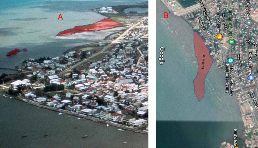
Photo A & B
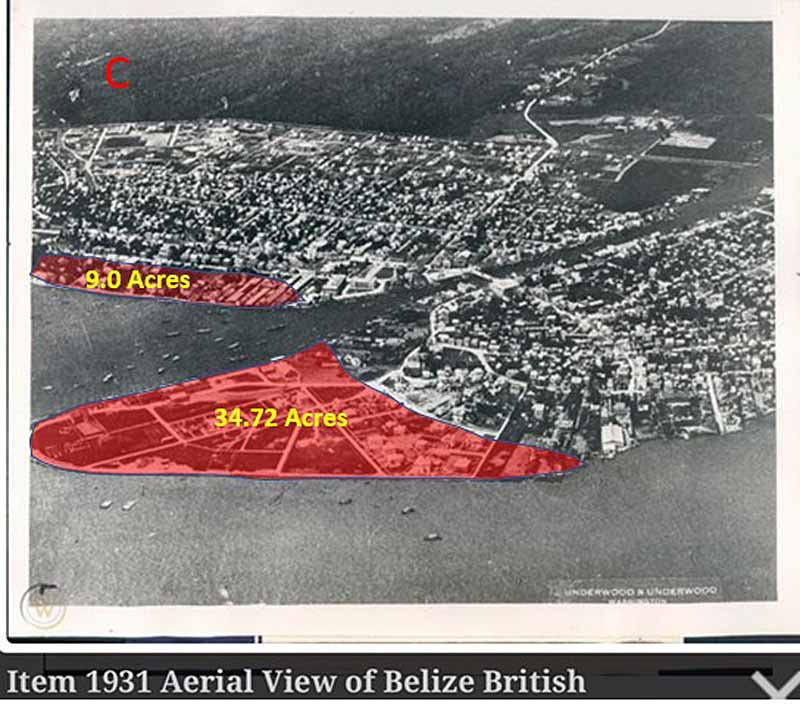
Photo C
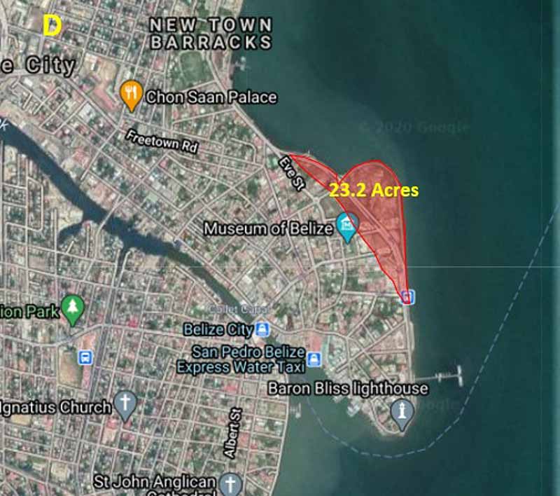
Photo D
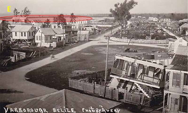
Photo E
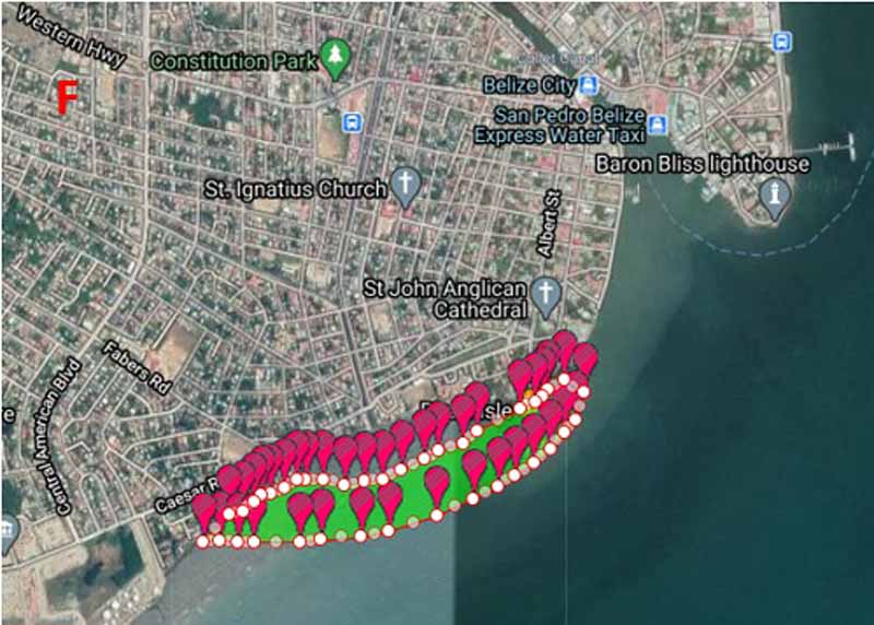
Photo F
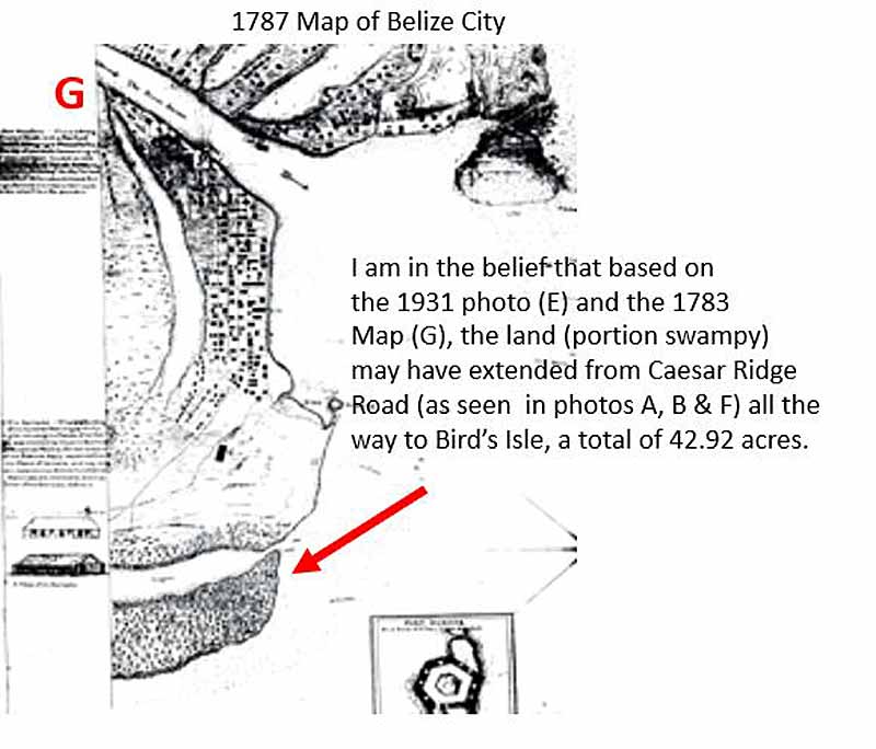
Photo G
I have seen quite a few vintage aerial photos of Belize City in our group. I am not sure if we are aware, but there has been sort of a tug and war between us trying to increase Belize City land size and mother nature taking away some, or a lot actually. This tug and war is evident from the various land reclamations to expand the City and a very large portion of land we have lost on the Southside over the last 200 years. Let me explain below how I came to this conclusion.
Based on some aerial view photos and an old 1787 map, I will reveal to you what we have gained and what I believe we have lost. The final tally though is that team “modernization’s reclamations " is ahead of team "mother nature’s erosion " by some 24 acres or 66.92 acres to 42.92 acres.
I will use a series of photos to illustrate this tug and war.
WHAT WE HAVE GAINED IN RECLAMATION IN ACRES
23.2 Acres at Marine Parade (Photo D)
34.72 Acres at Fort George (Photo C)
9.0 Acres at Foreshore (Photo C)
66.92 Acres in total (D & C)
WHAT WE HAVE LOST TO EROSION
42.92 Acres on Southside from what looked like a peninsula as demonstrated with photos A, B, & G.
MY BELIEF
Currently, what is depicted in photos A, B, & G (what looks like a peninsula extending from Caesar Ridge Road to Bird’s Isle) has been totally eroded over the last 220 years. Photo “A” was taken in the 60s and we can see that a considerable portion was still there to the equivalent of 15.68 acres including a small island ahead. Photo “B” is a recreation using Google Earth to demonstrate what it would look like currently if it was still there.
HOW I CAME TO MY BELIEF
A few days ago, I was looking at a 1931 photo of the Yarborough area (photo E) and I noticed something I had not seen before on that photo and thought it was unusual; it looked like a barrier island extending along the coast of Southside. I thought it was an anomaly because if you go to Yarborough there is nothing there only the sea all the way to the port and beyond. Then I saw the 1960's photo posted by Allan Jackson, which revealed a peninsula extending from Caesar Ridge Road (A) all the way to the Collet Canal bridge. According to Google Area Calculator App, that peninsula was 15.68 acres in size. After I saw the 1931 photo, things started to add up. I realized that the 1931 photo (E) was showing the same peninsula that was in photo “A “ although much larger. It seems that whatever was in front of the Yarborough did not stop where it stopped in the 1960s photo, but extended all the way in front of the Wesley College as captured in the photo. I started to think that if it had extended all the way to Wesley College, then how much further did it extend? The answer to this question would be revealed in a portion of a 1787 map I had seen some time ago. Photo “G “ is a copy of that map. Although one can only see a portion of what looks like an island that extended all the way to Bird's Isle, I am in the belief that that Island was the end of the peninsula we can see in the 1960s photo “A”. It seems that there was a peninsula that extended from the Caesar Ridge Road area all the way to Bird's Isle (F). So, when we did not see Bird's Isle in some of the other aerial views of Belize City and we thought it was a new island that was built, Bird's Isle was always there, only that it had been eroded over time.
Photo “F” is my estimation of the size of that peninsula which according to Google’s area calculator was about 42.92 acres. This peninsula may not have been solid land, but a combination of solid and low swampland. The 1931 photo made me realized that that peninsula was there when the tidal wave from the 1931 hurricane came ashore and would have taken some of the bite from that tidal wave. Loyola Park on the other hand, which was a little further ahead of this barrier peninsula, did not have the protection of this peninsula during the 1931 hurricane and that is why in my estimation, the tidal wave was so devastating for them as they took the full brunt.
CONCLUSION
In our tug and war with mother nature, we are ahead by sone 24 acres, but mother nature has and is taking land away from us that we are not aware of. In my estimation, we have lost about 20 feet in front of Government House over the years.
The Future Expansion of Belize City
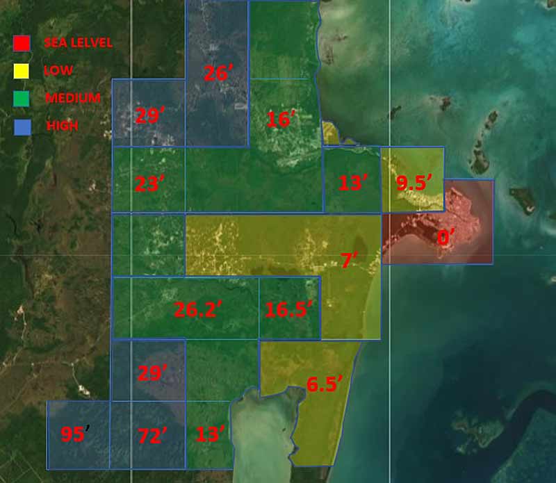
I have been thinking that with the precarious position Belize is in with our elevation and hurricanes, why don't' we have some kind of map that shows the elevations of the City. I know most of Belize City is very low, however, we do have some high areas. Why this is important is because, with the approach of a category five hurricane, which would deliver about 25 feet of water and submerge most two-story houses in Belize City, where can we go quickly? An elevation map would give us some idea where in the City our second-floor would be high enough. I am sure, however, that if that is the case there would be a mandatory evacuation of everybody, I hope. However, we have seen how hurricanes have blown-up in front of Belize City overnight. This reminds me of the case of Hurricane Keith. When I went to sleep it was a tropical storm in front of San Pedro and by the time I woke it was a category four. Would we be able to evacuate an entire City if that had happened with a category five?
I have been thinking that it would be more prudent if we started to think about our expansions in higher areas outside of Belize City rather than in the city. We should develop a plan and give residents incentives to relocate to this new area. I read the other day that a city that has the same problem as Belize so they are investing $900,000,000.00 USD to relocate their entire city. We don't have that kind of money, so we have to do it gradually, but we should start soon. The information above reveals the growth over the last 350 years. Where will we be in the next 100 to 200 years?
With the above situation in mind, I was looking at elevations of Belize City and the surrounding areas with the help of Google Draftlogic elevation finder. The diagram below is what that App revealed to me. I think the elevations need calibrating, however, it gives you an idea of where some of the highlands are located nearby. I think we should consider expanding in the blue and green areas.
Paul Pollard: Based on the photos I have seen and the limited knowledge I do have on the development of the early settlement, I wanted know why did the British choose the south side of the settlement for early development? Seems like all our landmarks are there - St. John's Cathedral among others on Regent Street and Albert Street. Even the names of the streets are strong colonial names.
Albert Paul Avila: I think maybe two reasons. The first is that it seems that the Southside land was higher and had less swamp between foreshore area and the natural canal at the back (the forerunner of the collet canal). According to Mr Sikaffey, that area around his store on Albert Street is very high. He said the land there under the street is Caye sand not mud. He said during Hattie the water there was only about six feet. All that area around Queen Street was Very swampy. The area of Paslow was filled because when we were digging a hole in the concrete base for the piles, we found pieces of a brain coral. I am attaching a photo of the piece I found. I still have it. It was part of a larger piece. Secondly, during the time of Edward Marcus Despard, who was our first Superintendent 1787 - 1790, Whitewall had instructed him to give first preference of newly acquired mahogany land in the Sibun area and some of the newly divided house lots on the south side to the new migrants that came from the Mosquito Coast in the 1786/87 great migration of about 2,500 whites, Enslaved Africans and Miskito Indians. So I think based on those two things the South side started to become more developed than the North side. Additionally, then when did the development occur? I am in the belief most happened between the 1787 and 1793. History tells us that a hurricane swept through the town in 1787 destroying all houses except one. The migrants came in 1786/87. The hurricane came through in 1787 . Despard was commanded to give lots to the migrants. Despard departed in 1790. The attached map is said to have been drawn in 1793. As you will see by that time there is a lot of development. So it seemed the between 1787 and 1793 there was lots of development.
Michelle Rivana Buckley:
I was told by my grandmother that the wealthy people lived on the south side and closer to Yarborough Green and Albert Street was where the Jesuits had homes. This was why the cemetery was in that area.
Harold Usher: I remember when everything passed Freetown Road and Mapp Street (Sawmill) was Mangrove Swamp! Yes, we had the Barracks and we had the Dump on top of which Pallotti was subsequently built! We constantly had to keep filling our yard on Usher Street, Victoria Street area! We used wooden chips from the Sawmill!
Luz Hunter:
I believe it's geography more than anything else. Looking at the city, it is situated on a promontory, sticking out into the sea. This was formed over the years by sediments brought to the coast from the mountains by the Belize River. In Belize, all currents flow north to south, regardless of wave action which is created by wind direction. These currents then, will cause the sediments to settle on the south side of the mouth of the river, creating more solid and higher ground. The true Belize River is the one that passes through Belize City, the opening at Haulover was man made and over time has widened and changed the flow of the Belize River to a trickle. Rivers are ever changing and the breakthrough between the river and the sea at Haulover bridge, is an example of how making changes in nature in one location causes changes miles away.
Lorraine Gomez:
Yes the canals my father told me were dug and built by Dutch engineers to drain the land due to its being at sea level. They were clean in the beginning.
Also many of the original creole families of good standing ( financially) built their homes on the canal sides. While the white expatriates did their on Waterfront like Foreshore.
Eugene Trench:
If you notice today the Northside seems more a planned area with yards having more spaces than the Southside I’m wondering if the Southside in the past seems was where everybody wants to live due to the fact I believe that’s where most of the slaves lived. The city on the Northside wasn’t developed. In those days I believe due to transportation all merchants were crowded on Albert, Queen, Orange& North Front Streets, even the financial institutions were in all one area. It was not into the late 20th century people decided to start moving out of congestion.
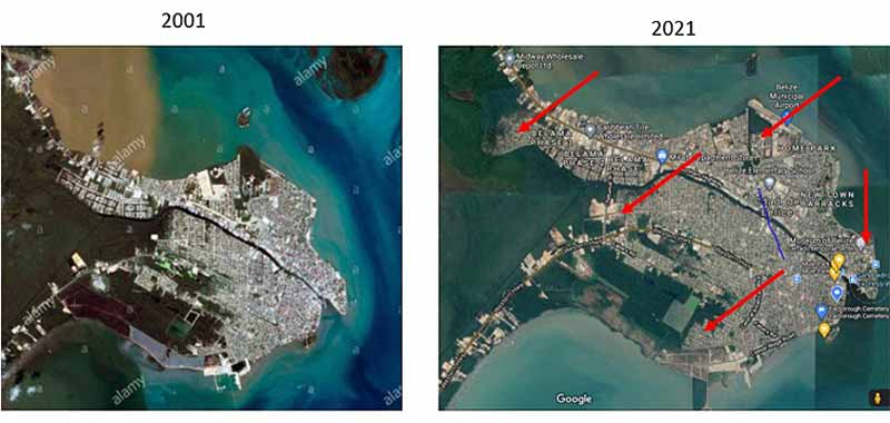
Over the last twenty years Belize City has had some changes due to expansion. Take a look at the areas where it occurred.
Karl M Leacock Sr.:
You see the plume of brown sediments from of the mouth of the Belize River near Haulover Bridge.
Albert Paul Avila:
But it is interesting that the flood water running through Belize City does not look brown.
Karl M Leacock Sr.: But remember Haulover Creek is longer so sediments will settle out and currents from sea for the former. NASA satellite photographs do show the darken area of both and the one from the Sewer Lagoon. Had some photographs but can not find them otherwise would post.
Photographs by Albert Paul Avila
Click here to comment on this picture.

Click here for a list of previous pictures of the day
Click here for a large selection of photographs and videos of Belize
 Email us - We Email us - We your photographs. Send us yours with a description! your photographs. Send us yours with a description!
 Belize Search.com
Belize News.com
Belize Cards.com
Belize History
IslandBazaar.net
Belize Weather
Belize Search.com
Belize News.com
Belize Cards.com
Belize History
IslandBazaar.net
Belize Weather
Belize Lodging
Tours & Recreation
Diving & Snorkeling
Fishing
Travel Tips
Real Estate
AmbergrisCaye.com
Island Information
Visitor Center
Belize Business
San Pedro Sun
SanPedroDaily.com
Belize Message Board
Restaurants
Things to do
|