|
|
Joined: Oct 1999
Posts: 84,404
|
OP

|

Ernesto reaches hurricane strength as it approaches the Yucatan
Jeff Masters
8:55 PM GMT on August 07, 2012
Ernesto strengthened to a category 1 hurricane this afternoon after the morning hurricane hunter mission found winds of 80 mph, which is unusual for a hurricane without an eye wall. The hunters also found a minimum central pressure of 984 mb, which has dropped since this morning. The next hurricane hunter mission is scheduled to reach the center of the hurricane around 8pm EDT. The rain bands from Ernesto have reached the coast of Belize and Mexico as it continues to move west along the coast of Honduras, and landfall is expected north of the the Belize/Mexico border tonight around midnight. The Yucatan Basin buoy is now reporting gusts up to 53 mph, with sustained winds around 40 mph and 19 foot waves. These gusts are about 10 mph stronger than this morning's readings. Weather stations along the coast of Mexico and Belize aren't reporting winds stronger than 10 mph, however, they are expected to pick up around 8 or 9pm EDT tonight. The island of Roatan in Honduras is experiencing winds around 15 mph this afternoon, along with some light to moderate rainfall. Honduras seems to be the most impacted country so far, although they have avoided issuing evacuations. Nicaragua, however, has evacuated 1,500 people as of last night, and Mexico's authorities have evacuated around 600 residents from Punta Allen, which is a fishing village between Cozumel and Chetumal.
Visible satellite imagery suggests Ernesto still has the potential to develop an eye wall before landfall, as strong, organized thunderstorms are present in all four quadrants of the hurricane. Infrared satellite imagery shows the clockwise circulation at high levels (the upper level anti-cyclone) which will help ventilate the hurricane and could support further enhancement. If Ernesto wasn't approaching landfall, it would likely continue to strengthen and could have even experienced a period of rapid intensification, given the heat content of the Caribbean Sea. Wind shear around the hurricane remains low at 5-10 knots.

Figure 1. Radar image from Belize as the outer rain bands of Ernesto approach. This image was captured at 2:30pm EDT.

Figure 2. IR satellite imagery of Hurricane Ernesto captured at 4:15pm EDT.
Forecast for Ernesto
Ernesto will continue to track west this afternoon and evening, making landfall north of the Belize/Mexico border around midnight tonight. Given the current state of the hurricane, some more intensification is possible over the next few hours as it approaches land. Heavy rains continue to be the main threat from Hurricane Ernesto. The Hurricane Center is forecasting 4 to 8 inches of rain to fall, increasing in the higher elevation of Belize. After landfall, the storm will take about a day to cross the Yucatan, and the terrain will diminish its winds. Once Ernesto re-emerges over water into the Bay of Campeche in the southern Gulf of Mexico, wind shear will be light and ocean waters warm with high heat content. Ernesto is then expected to redevelop some strength and potentially regain hurricane status while over water, which a few of the models are suggesting. Second landfall will probably occur Friday morning around Veracruz, Mexico, but could reach land anywhere from Tuxapan to Coatzacoalcos.

Figure 3. Webcam image from Caye Walker Village in Belize.
Click here for the full Tropical Weather Report, updated several times a day during storms...
|
|
|
|
|
Joined: Oct 1999
Posts: 84,404
|
|
OP
|

Coming in the Royal Palms entrance...lots of gross stuff washing up. Even a aluminum soup pot.

San Pedro Scoop
|
|
|
|
|
Joined: Oct 1999
Posts: 84,404
|
|
OP
|

(Click image for larger version)
NEMO Public Advisory # 9
HURRICANE ERNESTO
TIME: 3:00 P.M.
LOCATION: 18.8N 86.2W
HURRICANE FORCE WINDS EXTEND OUTWARD UP TO 35 MILES FROM THE CENTER
TROPICAL FORCE WINDS EXTEND OUTWARDS UP TO 140 MILES FROM THE CENTER
MAXIMUM SUSTAINED WINDS: 80 MPH
PRESENT MOVEMENT: WEST NORTH WEST AT 15 MPH
Hurricane Warning Red II is in effect for Belize City Northward to the Mexican Border. A Tropical Storm Warning is in effect for the Southern part of the Country.
Ernesto is expected to produce accumulation of 3-5 inches. These rains are likely to cause dangerous FLASH FLOODS.
NEMO hereby relaxes the order on restaurants and grocery shops in the Cayo, Stann Creek and Toledo Districts.
NEMO remains on full alert as it continues to monitor Hurricane Ernesto.

Last edited by Marty; 08/07/12 05:15 PM.
|
|
|
|
|
Joined: Aug 2012
Posts: 1
|
|
|
These shots are great. We just spent a couple of weeks at the Pelican Reef and then the Xanadu. We made lots of friends with the staff and other locals. If you can please post/send shots of the Pelican and Xanadu. Or Marina's store. We spent many a day biking up and done the road into San Pedro to and from the hotels.
We hope you are all safe!!
|
|
|
|
|
Joined: Oct 1999
Posts: 84,404
|
|
OP
|
Satellite view and track for Hurricane Ernesto at 6pm Belize time today
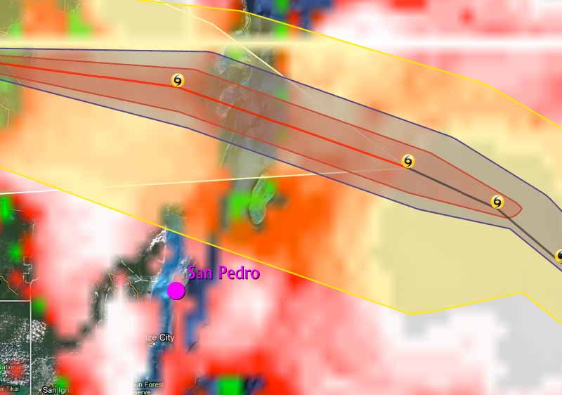 

Water higher.... wind now about 20-25 mph..
San Pedro Scoop Just rain to this point. Very little storm surge so far.
With Tropical Storm Ernesto upgraded to Category 1 Hurricane status, preparations continued into Tuesday on La Isla Bonita...
San Pedro Sun
|
|
|
|
|
Joined: Oct 2005
Posts: 254
|
|
|
Welcome to dinner Hurricane Ernesto. Tonight we are having carnitas tacos with guacamole. The dogs have had their bath and are sleeping inside being quiet. So far just high surge and the winds have started. Stayed tuned for a video of the waves. Basil Jones, North Ambergris Caye ![[Linked Image]](https://lh3.googleusercontent.com/-b8jgqdPKBPE/UCG3b49yT1I/AAAAAAAADzY/cpTUGVHMP5w/s679/DSCN2362.JPG)
Last edited by Chica Blanca; 08/07/12 07:55 PM.
Coleen
Beach bum, butterfly stalker, native plant enthusiast.
|
|
|
|
|
Joined: Oct 1999
Posts: 84,404
|
|
OP
|


Here are high res images and the Hurrevac track of Ernesto. Also attached is the 250km radar loop. Landfall is expected within the next 3- 6 hours. Of interest is a jag to the W'S (260 deg) of the track of the center of Ernesto from the 3:00 pm positon. At this point Ernesto can only make landfall along or just south of 18.7N, the present latitude of Ernesto. This will bring TS force winds farther south into northern Belize. So we cannot let down the guard. People in the north should therefore be prepared for an increase in winds upon and just after landfall tonight. The rainfall projection still holds. Accumultions of 4-8 inches possible over some parts of Belize with higher amounts of up to 10-12 inches in the hilly terrain, before this is all over. We must therefore watch for any further shift of the center closer to Chetumal at landfall.
RFrutos
6:30pm... relatively quiet...light rain...light winds. The reef is taking a beating but all fine on land. We've had about 3 inches of rain in the last 24 hours. It's downright chilly out. 79! Everything is good. We have blustery wind. The sea is up high and I think the beaches and docks will suffer some damage, but the hurricane will miss us, but will hit north of us. So, we need to think of our close neighbours north and hope that they are OK and well prepared. Ernesto is not strong, but a very timely reminder of what may be to come. 9:30pm.... Winds now gusting to 30-35 mph...
|
|
|
|
|
Joined: Oct 1999
Posts: 84,404
|
|
OP
|


Well, hurricane Ernesto about to make landfall along the southern coast of the Yucatan peninsula with 85 mph winds, at a location some 49 miles ENE (065deg) of Corozal Town, and 57 miles N'E (018 deg) Most of the heavy convection is still offshore.
However...imagery from the Belize radar indicate the hurricane had a well-defined 15-nmi diameter eye earlier this evening...but the eye has become a little ragged over the past couple of hours.
...Belize radar indicates Ernesto has made landfall along the southern Yucatan coast...
At 1000 PM CDT...0300 UTC...data from the Belize radar indicate
Hurricane Ernesto made landfall along the southern coast of the
Yucatan Peninsula near mahahual Mexico as a category 1 hurricane.
|
|
|
|
|
Joined: Oct 1999
Posts: 84,404
|
|
OP
|

Ernesto Pics aboard Coastal Xpress, plus latest track
After evacuation of US Tourist, here's some pics back to town in serious Ernesto weather

|
|
|
|
|
Joined: Oct 1999
Posts: 84,404
|
|
OP
|
|
|
|
|
S |
M |
T |
W |
T |
F |
S |
|
|
|
|
1
|
2
|
3
|
4
|
|
5
|
6
|
7
|
8
|
9
|
10
|
11
|
|
12
|
13
|
14
|
15
|
16
|
17
|
18
|
|
19
|
20
|
21
|
22
|
23
|
24
|
25
|
|
26
|
27
|
28
|
29
|
30
|
31
|
|
|
|
0 members (),
3,918
guests, and
0
robots. |
|
Key:
Admin,
Global Mod,
Mod
|
|
|
Forums44
Topics79,268
Posts500,180
Members20,759
| |
Most Online20,577
Mar 30th, 2026
|
|
|
|


 AmbergrisCaye.com