|
|
Joined: Oct 1999
Posts: 84,400
|
OP

|
Belize Weather Forecast: October 7, 2018
 General Situation:
Ambergris Caye: Conditions this morning by Elbert just before or after this post!
Belize NMS:
Tropical depression #14 over the northwest Caribbean Sea maintains relatively moist and unstable conditions over our area.
Advisories: *Small craft caution in effect for gusty winds and occasionally rough seas.
Some localized flooding is likely in flood prone and low lying areas during the next couple of days.*
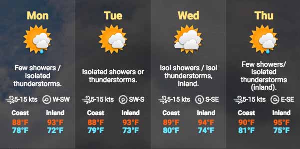
24-hour forecast:
Skies will be sunny with some cloudy spells today and cloudy at times tonight. Some showers, thunderstorms or periods of rain will occur mostly over inland areas this afternoon then spread to along some coastal areas tonight.
Winds:
West-Southwest | 10-20 kts | Gusty, Sea State: Moderate
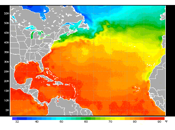
Sea Surface Temperature (°f): 84
General Outlook:
For Monday and Monday night is for some cloudy spells with a few showers and isolated thunderstorms mostly over inland and northern areas of the country.
Daily Tropical Weather Outlook:
At 3:00am Tropical Depression #fourteen was centered near latitude 18.6N longitude 86.9W or about 90mls East of Chetumal Mexico. The depression was moving NNW at 3mph with maximum sustained winds of 35mph. This system is likely to become a tropical storm later today or tonight and likely to produce heavy rains over the Yucatan Peninsula, Belize and northern Honduras during the next couple of days. At 3:00pm Tropical Storm Leslie was centered about 800mls East-Northeast of Bermuda and moving to the East at 12mph with maximum sustained winds of 60mph. Elsewhere, tropical cyclone formation is not expected during the next 48 hours.
Click for more...
Marine Conditions:
| |
Winds |
Seas |
Waves |
Details |
| Today |
W-SW 10-20 kts |
Moderate |
4-6 ft |
SOME SHOWERS OR THUNDERSTORMS, INCREASING LATE. |
| Tonight |
SW 10-20 kts |
Choppy |
3-5 ft |
SOME SHOWERS OR THUNDERSTORMS, DECREASING. |
| Tomorrow |
SW-S 5-15 kts |
Choppy |
3-5 ft |
A FEW SHOWERS OR THUNDERSTORMS, LATE. |
| Outlook |
S-SE 5-15 kts |
Choppy |
3-5 ft |
A FEW SHOWERS OR THUNDERSTORMS. |
The Caribbean Sea
The center of POTENTIAL TROPICAL CYCLONE FOURTEEN 07/0300 UTC is
near 18.8N 86.6W, in the NW corner of the area.
An E-to-W/NE-to-SW oriented ridge covers most of the rest of the
area, away from the area of the Potential Tropical Cyclone.
Isolated moderate to locally strong rainshowers cover the rest of
the area that is from 15N northward between 60W and 78W.
Potential Tropical Cyclone Fourteen near 18.8N 86.6W 1004 mb at
11 PM EDT moving N at 6 kt. Maximum sustained winds 25 kt gusts 35
kt. Fourteen will move to 19.5N 86.5W Sun morning, 21.0N 86.2W
Sun evening, 22.3N 86.1W Mon morning, 23.8N 86.3W Mon evening, and
27.4N 87.2W Tue evening. Fourteen will move inland near 32.0N
85.0W late Wed, and inland over 38.5N 77.5W Thu.
| |
High |
Low |
| Coastal |
31° C
88° F
|
26° C
78° F
|
| Inland |
34° C
93° F
|
23° C
73° F
|
| Hills |
28° C
82° F
|
20° C
68° F
|
| TIDES: |
|
| High: 8:37 AM |
Low: 2:50 PM |
| High: 9:05 PM |
Low: 3:01 AM (Mon) |
| Sunrise: 5:37 AM |
Moonset: 4:53 PM |
| Sunset: 5:36 PM |
Moonrise: 5:12 AM (Mon) |
Four Day Weather Outlook:
For more information, check the Daily Tropical Weather Outlook.
CLICK here and here for detailed local weather data
Climate Prediction Center's Central America Hazards Outlook
Current Conditions and weather history for Ambergris Caye / San Pedro
Current Caye Caulker Weather Information
Belize National Emergency Management Organization (NEMO)
|
|
|
|
|
|
Joined: Oct 1999
Posts: 84,400
|
|
OP
|
From Elbert....
We have a heavy overcast and wind seems to be from the back pushing sargasa out to sea. The sea around the barrier reef is flat calm because it's in the Lee. We have a surge now and then that tells me that some heavy weather is out in the Caribbean sea.
|
|
|
|
|
Joined: Oct 1999
Posts: 84,400
|
|
OP
|
From Belmopan...
We have a large storm right on our door step this morning.
The wind directions have completely changed over night because this storm has wound up and is now seriously rotating. TROPICAL DEPRESSION FOURTEEN developed over night very rapidly. They now think it could reach Hurricane force winds as it crosses the Gulf up to Louisiana.
Our weather looks fairly typical, namely cloud, with a little blue sky patches, BUT no rain on land, and surprisingly, despite that very, very dark storm area, not much rain out at sea under that lot. But the winds are coming in from the NW and further south, from the west.
Looks as if this will result in a fairly pleasant weather day for us, cool, sun and cloud, but little or no rain.
Temperatures in Belmopan :
( Coast usually cooler, hills even cooler )
Last night min. 25°C 76°F Yesterday max. 30°C 86°F
Ambergris Caye:
https://www.wunderground.com/q/locid:BHXX0104;loctype:1
Belmopan:
https://www.wunderground.com/personal-weather-station/dashboard?ID=MD1029#history
Caye Caulker:
https://www.wunderground.com/personal-weather-station/dashboard?ID=IBELIZED2#history
|
|
|
|
|
Joined: Oct 1999
Posts: 84,400
|
|
OP
|
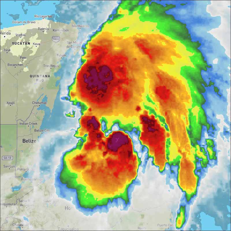
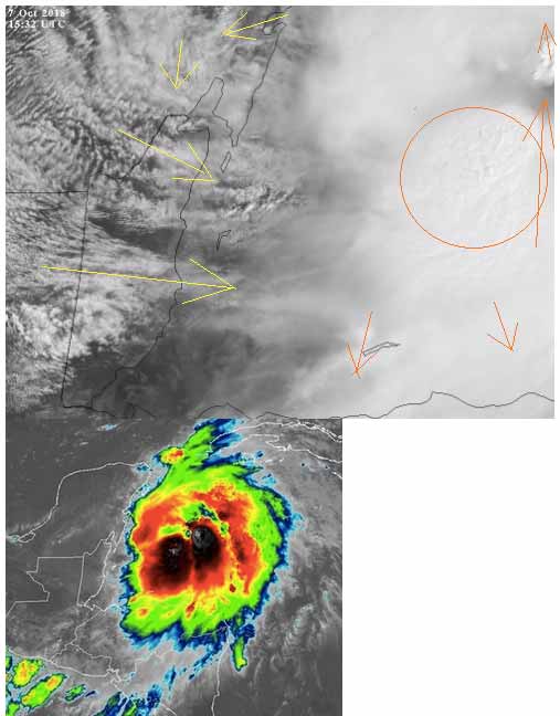
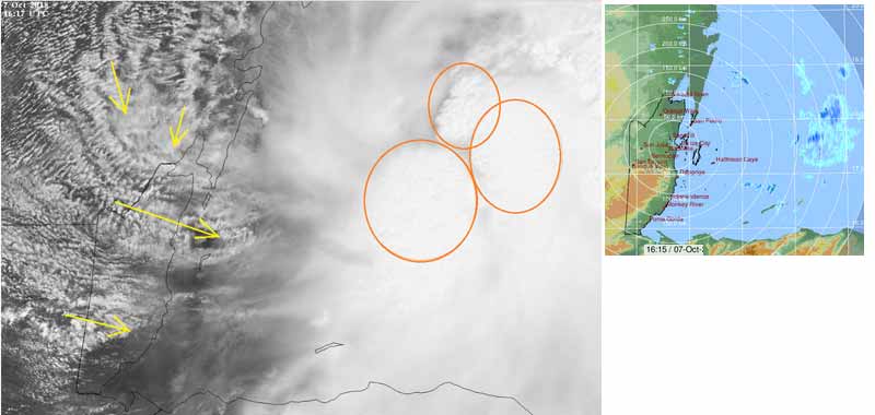
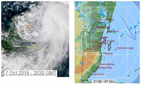
The Cloud picture and rain picture.
|
|
|
|
|
Joined: Oct 1999
Posts: 84,400
|
|
OP
|
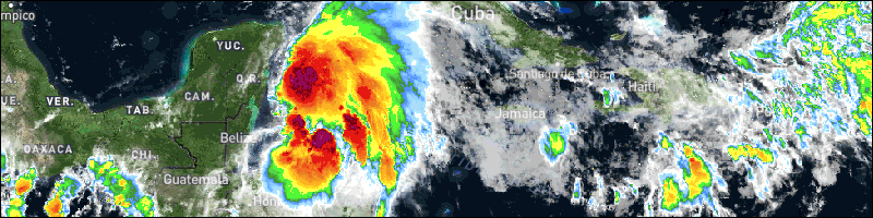
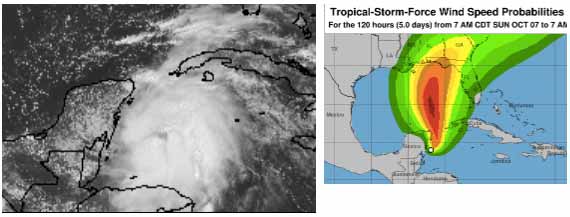
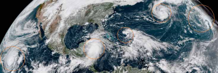
Updated satellite view. TROPICAL STORM MICHAEL HEADS NORTH AWAY OF BELIZE ![[Linked Image]](//Ambergriscaye.com/art7/dailywx181007b.jpg)
|
|
|
|
|
Joined: Oct 1999
Posts: 84,400
|
|
OP
|
There are quite a few rotating air masses at present. There is a small one that formed from a spin-off from Leslie, that could go to Florida. There is another north Atlantic rotation INVEST 92L, close to Spain, again the result of the Jet stream and effects from Leslie. Then there is the storm near to Belize, now called TROPICAL STORM MICHAEL which is behaving very oddly. I certainly can not see any high winds near its centre which I see as still 125 miles east of Chetumal at 18°57'18.33"N 85°32'46.28"W which is not where they say it is.
Regarding Michael, I have again, carefully checked their quoted location of 19.2 N 86.9 W.
There are actually two different levels of cloud movement at that location and neither is moving at any storm speed. Looks to me as if they are measuring the outflow speed from the swellups much further to the east, nearer to where the actual centre of rotation is, also I do not see it as a Storm yet, but hay, if we say it is 40 mph who can challenge us, and 40 mph is Storm force. Very little rain, and what there is is moving away, towards the ESE, odd. How, why do they get these things wrong, perhaps because it is not yet a threat to the USA.
|
|
|
|
|
Joined: Oct 1999
Posts: 84,400
|
|
OP
|
Even odder, in some respects. The easterly Caribbean winds and cloud has been going more or less normally over Cuba into the Gulf. But then turning round in the Gulf and coming down over southern Mexico and continuing to turn and come in over Belize from the west.
Is it the storm causing this Caribbean air to change direction, or is there something in the Gulf causing the wind to change direction and in turn, cause that cloud off Belize to develop into many ITCZ swellups, without much rain?
There are easterly Caribbean winds and clouds going over the Yucatan still and now. And as typical, they have been getting higher during the heat of the day, and clashing with high level winds from the SW as usual and developing many rain showers all over the Yucatan. Which are now coming down into Belize from the north. This is well away from the supposed storm.
|
|
|
|
S |
M |
T |
W |
T |
F |
S |
|
|
1
|
2
|
3
|
4
|
5
|
6
|
|
7
|
8
|
9
|
10
|
11
|
12
|
13
|
|
14
|
15
|
16
|
17
|
18
|
19
|
20
|
|
21
|
22
|
23
|
24
|
25
|
26
|
27
|
|
28
|
29
|
30
|
31
|
|
|
|
|
|
0 members (),
93
guests, and
0
robots. |
|
Key:
Admin,
Global Mod,
Mod
|
|
|
Forums44
Topics79,209
Posts500,044
Members20,484
| |
Most Online7,413
Nov 7th, 2021
|
|
|
|

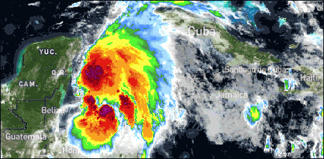
![[Linked Image]](http://Ambergriscaye.com/art7/dailywx181007b.jpg)


