
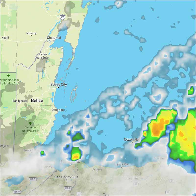
...Heavy rainfall event for Central America...
A 1008 mb surface low is centered over the SW Caribbean near
09N81W. The low is forecast to move WNW toward Central America
early next week, and some development is possible if the low moves
over the northwestern Caribbean Sea near the coasts of Honduras,
Guatemala, and Belize. Regardless of development, this system
could bring heavy rains to portions of Central America late this
weekend through early next week.
A broad area of low pressure located over the southwestern
Caribbean Sea is producing disorganized showers and thunderstorms.
This system is expected to move west-northwestward toward Central
America, and some development is possible if the low remains over
water when it is near the coasts of Honduras, Guatemala, and
Belize on Monday and Tuesday. Regardless of development, this
system could bring heavy rains to portions of Central America during
the next few days.
* Formation chance through 48 hours...low...10 percent.
* Formation chance through 5 days...low...20 percent.
Over the southwestern Caribbean, an area of low pressure has formed amid a broad counter-clockwise wind pattern, known as a gyre. "This area of low pressure will track into or along the north coast of Central America early this week," Kottlowski said.
If the system's circulation remains over the warm waters of the Gulf of Honduras for a time, there will be a better chance for it to become an organized tropical system.
Drenching showers and thunderstorms are likely over portions of Costa Rica, Nicaragua, Honduras, El Salvador, Belize, Guatemala and the Yucatan Peninsula into Tuesday, even if an organized tropical system fails to form.
This disturbance is expected to cross the Yucatan Peninsula and emerge in the Bay of Campeche by midweek. Here, there may be another opportunity for it to organize.
Regardless, drenching flooding rainfall will be possible in portions of eastern Mexico during the second half of the week. Some of this rain could be drawn northward into the western Gulf Coast.


For more information, check the daily Tropical Weather Outlook, click here.


 General Situation:


![[Linked Image]](http://Ambergriscaye.com/art8/belmopanwx191013.jpg)
![[Linked Image]](http://Ambergriscaye.com/art8/belmopanwx191013c.jpg)
![[Linked Image]](http://Ambergriscaye.com/art8/belmopanwx191013d.jpg)
![[Linked Image]](http://Ambergriscaye.com/art8/belmopanwx191013k.jpg)


