|
| 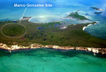
The Marco Gonzalez Site is about 185 x 355 m in size, and it is readily visible from the air immediately before landing in San Pedro from Belize International Airport. The low-lying area around the site is close to sea level, and it is a "mangal" jungle-swamp of red mangroves (Rhizophora mangle) and black mangroves (Avicennia nitida). Surface deposits of this swamp are mainly mangrove "peat" (the predecessor of coal) that overlie carbonate sands and muds. Two small areas of Pleistocene limestone, the "bedrock" of Ambergris Caye, are exposed along the shore to the north of the site. The site is topographically higher than the surrounding swamps, its maximum elevation being about 3.6 meters above sea level. It is covered by white mangrove (Laguncularia racemosa), gumbo-limbo (Bursera simaruba), white poisonwood ("chechem", Cameraria belizensis), silver palmettos (Thrinax sp.), cabbage palms (Roystonea oleracea), and a variety of vines, sedges, and grasses. 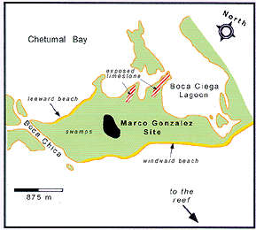 The site is higher than the surrounding mosquito-infested swamps because of human activities, specifically, buildup of the area resulting from millenia of accumulated, typically dark colored "anthrosol", which is soil composed primarily of artifacts (e.g., pottery, tools), conch and other shells, building remains, processing debris, and other wastes from human activities. Common lore has it that the Maya brought in the dark soil that surrounds all sites on the caye, but that is erroneous; all such "anthrosol" is a natural product of long-lived habitation at each site. The presence of artifacts below the present-day surface, particularly beneath the mangal swamps, indicates that the site was once larger than is presently exposed. The site is higher than the surrounding mosquito-infested swamps because of human activities, specifically, buildup of the area resulting from millenia of accumulated, typically dark colored "anthrosol", which is soil composed primarily of artifacts (e.g., pottery, tools), conch and other shells, building remains, processing debris, and other wastes from human activities. Common lore has it that the Maya brought in the dark soil that surrounds all sites on the caye, but that is erroneous; all such "anthrosol" is a natural product of long-lived habitation at each site. The presence of artifacts below the present-day surface, particularly beneath the mangal swamps, indicates that the site was once larger than is presently exposed.
by Dr. S. J. Mazzullo, Department of Geology, Wichita State University, Wichita, Kansas |

|