|
|
A detailed geological history of southern Ambergris Caye and the Marco Gonzalez area was formulated by R.K. Dunn in his Masters thesis done under the supervision of Dr. S. J. Mazzullo at Wichita State University; the thesis was later published by Dunn and Mazzullo (1993). The results of this study shed some light on the history of Maya habitation at the Marco Gonzalez Site, and suggests a possible reason why the site was abruptly abandoned around 500 years ago. The sea level history curve shown above indicates that sea level in northern offshore Belize, and around the world for that matter, rose rapidly from about 6200 years ago to 4800 years ago, and then the rate of rise slowed thereafter until present sea level stand was reached less than 500 years ago. The rise in sea level reflected final melting of the glaciers that had once covered large parts of the Earth from 2 million to 10,000 years ago. The geography of the coastal area around Marco Gonzalez changed as sea level rose, and such changes strongly affected habitation at the site.
At about 2000 years ago, the approximate time of initial habitation of the site, sea level had risen to about 0.6 meters lower than present. The Marco Gonzalez site initially occupied one of these now-smaller islands, which likewise was surrounded by warm, clear, shallow water. The area must have been a lovely setting, with 360o views and constant sea breezes. Boat access to the
site was unimpeded, and in fact, the deep waters of Boca Chica Channel (5 meters deep) would have allowed ready access to canoes loaded with building stones and other supplies that could have easily been carried to the site across a relatively narrow expanse of shallow water that probably was less than half a meter deep. The windward beach had begun to accrete laterally from the northeast, blocking off access to currents and allowing mangrove swamps to begin forming some distance north of the site.
by Dr. S. J. Mazzullo, Department of Geology, Wichita State University, Wichita, Kansas |
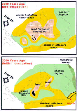 About 3800 years ago (pre-occupation), for example, sea level was about 1 meter lower than at present, and the area around Marco Gonzalez was two adjoining low islands, on limestone bedrock, surrounded by shallow water. The beach that exists now along the windward side of the caye was not present at this time.
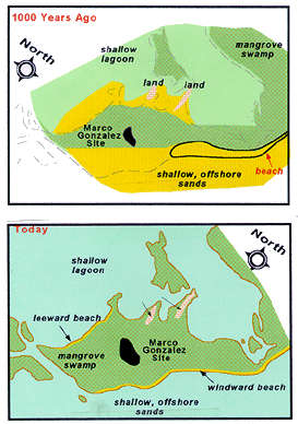 By about 1000 years ago, just before the apex of community development, sea level had risen to about 0.25 meters below present stand. The windward beach had accreted farther south, and mangrove swamps began to surround the site. The Maya continued to live there, however, because the site still stood as a high area, because of accumulated anthrosol, that was still relatively open to sea breezes.

|