Two weeks ago routine life on San Pedro, Ambergris Caye and Belize came to a sudden halt when Hurricane Mitch became a threat to the country on Sunday, October 25th, 1998. Hurricane Mitch developed from a tropical depression outside the coast of Panama. From there it took on a northerly track, heading straight to the islands of Jamaica and the Cayman Islands. On Sunday, October 25th, Hurricane Mitch took a turn for the worst when it started moving to the northwest posing a serious threat to Belize. The government of Belize moved very quickly to alert every town and village and started discussing emergency preparations.
The San Pedro Town Board held an open meeting on Sunday,
October 25th at 4:00 p.m. to inform the
public of the alert. After the meeting the San Pedro Hurricane Committee met to
discuss and plan the necessary hurricane procedures that the island had to take.
Members of the committee were all assigned different duties and immediately
started working on evacuation procedures, establishing medical and
communications centers, preparing hurricane shelters and so forth. The San Pedro
Town Hall stayed open all night with members of the committee and volunteers
working on the hurricane procedures.
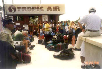
By early Monday morning, thousands of islanders had rushed to
the airstrip and the piers to leave the island; Hurricane Mitch was moving
towards Belize with winds over 150 mph. The government never issued a mandatory
evacuation of the islands and coast line, but San Pedro and Caye Caulker were
preparing for the worst. A voluntary evacuation was issued in San Pedro, but the
Hurricane Committee advised the islanders to leave at the first opportunity they
could get. Maya Island Air and Tropic Air did an extraordinary job of evacuating
as many people as possible. They had non-stop flights to Belize City evacuating
approximately 1000 people per airline on Monday alone. Once in the city, people
went to family members, to bus terminals and taxies and traveled inland to many
towns and villages. Water taxis made trips to Belize City and many people left
with privately owned skiffs which offered rides to anyone who was waiting at the
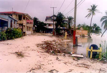
piers. Those who did not leave on Monday were busy boarding up the windows of
their houses and businesses. The demand for plywood was very high and due to the
rush there was a shortage by Tuesday. Water had to be rationed to keep an
emergency supply on hand. Meanwhile, the Hurricane Committee kept on working to
provide all the services possible to the island.
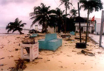
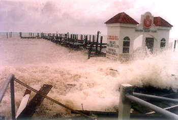
By late Monday afternoon, those who were still on the island
could hear the rage of the Caribbean Sea, just outside the barrier reef. Huge
waves rose much higher than 20 feet as they battered the reef that was fighting
to protect the island. Residents kept a close eye on Mitch as it reached its
highest potential of 180 mph; a super, category 5 hurricane labeled as
catastrophic. By the end of the day, approximately 6,000 people had evacuated
the island. Those who remained made plans to leave as early as possible the
following day.
Crowds gathered as early as 4:00 a.m. at the airstrip on
Tuesday so that they could be a few of the lucky ones to be able to leave the
island. The airlines' pilots voluntarily stayed behind to evacuate as many
people as they could and flew up to the point where weather conditions
permitted. Around 10:00 to 11:00 a.m. there were no more flights and people had
to rush for the water taxis and other skiffs that were helping evacuate people.
By the end of the day, people started moving into the designated shelters and to
houses which they thought were strong enough to withstand the hurricane.
Hurricane Mitch baffled hurricane experts with its
unpredictable movement. They could not predict or estimate an area which it
would strike. The only thing everybody could do was wait. By Wednesday, October
28th Mitch was situated directly over
the islands of Guanaja and Roatan off the coast of Honduras. It was drifting
westward at five miles per hour and at times was almost stationary. Hurricane
Mitch then proceeded to move to the southeast and moved over land in Honduras
where it lost its strength and was classified as a category one hurricane by
Friday. A sigh of relief fell upon the entire country, yet many felt concerned
for the people of Honduras.
Nevertheless, San Pedro was spared and continues to be "La
Isla Bonita." The island is up and running and the entire community is
working as one to help restore what was damaged and lost. Hotels are in full
gear, dive shops and tourist guides are already providing trips to the beautiful
coral reef and the island is still expecting a prosperous tourist season.
Our hearts, prayers and helping hands extend to the islands and communities
of Honduras, Nicaragua, Guatemala and El Salvador who suffered the wrath of
Hurricane Mitch. Many have lost their homes and even loved ones. As sister
countries, Belize is here to help in any way possible.
Copyright San Pedro Sun.. Design by Casado Internet Group |