
San Pedro,
Ambergris Caye
Where and
what is it?
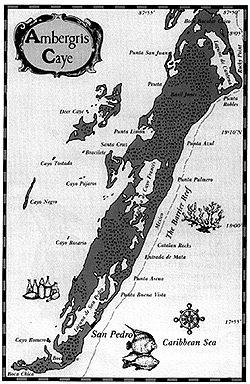
Ambergris Caye is Belize's largest island and is one of more than 200 islands scattered throughout Belizean waters. Ambergris Caye is about an hour and a half away from mainland Belize by boat and about 13 minutes plane. The island is about 25 miles long from Boca Bacalar Chico in the north to Boca Chica in the south.
Less than four miles from the shore lies the longest reef formation in the stem Hemisphere, the Belize Barrier Reef. The Reef runs almost parallel with the island except at Mexico Rocks where the Reef touches the ore. Mexico Rocks is an area in the north, on the front side of the island, out seven miles from Boca Bacalar Chico. Boca Bacalar Chico is a narrow shallow channel believed to have been dredged by Mayans. The Mayans believed to have used the channel as a short cut to trade with other Mayans in Mexico and mainland Belize. The channel separates Belize from Mexico.
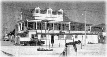 Blake House (Barrier Reef) early 19th century
|
The island is made up of three main geographic features: lagoons, sand, and mangrove swamps. The front of the island mainly consists of sand, and grove swamps; the leeward side of the island is made up of more swamps lagoons; rich black dirt is also found in back of the island. The largest on on the island is called Laguna de San Pedro and is situated directly hind the town of San Pedro.
San Pedro Town is the most populated area of Ambergris Caye. There e several other small settlements on the island such as San Pablo, Tres Cocos and Basil Jones. San Pedro is the only town on the island. It is estimated that San Pedro's population is about 7, 000.
In 1848 San Pedro was declared a town. Making San Pedro Town 150 years old on June 2911, 1998.

Copyright by Casado Internet Group