|
|
Joined: Oct 1999
Posts: 84,398
|
OP

|
Current track brings this into our area Tuesday morning as a Cat 1 Hurricane.... 
Potential Tropical Cyclone Nine is expected to track westward into the Windward Islands Friday. It will still bring heavy rainfall and strong gusty winds to the Windward Islands Friday and Friday night. Interests on those islands should be prepared for localized flooding and perhaps very localized mudslides. Winds might be strong enough to cause some utility disruptions. The system will track westward probably north of the ABC Islands and remain north of South America. The system will move over very warm water and if the shear remains low enough, this system could become a strong tropical cyclone. Computer forecasts show it tracking westward across the southern Caribbean Saturday through early next week. The system could become a strong tropical cyclone before moving very close to and then over Central America next week.

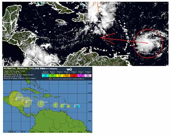
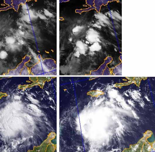
| Figure 1. Visible-wavelength GOES-16 satellite image of Potential Tropical Cyclone 9 as of 1515Z (11:15 am EDT) Thursday, August 17, 2017. GOES-16 data are preliminary and non-operational. The RAMMB site also has a "floater" loop zoomed in on PTC 9, offering vivid detail. Image credit: RAMMB/CIRA @ CSU. |
Potential Tropical Cyclone 9 heading toward CaribbeanThe NOAA/NWS National Hurricane Center launched advisories on Potential Tropical Cyclone 9 (formerly Invest 91) on Thursday morning. As we discussed back in June, the new PTC designation allows for more detailed guidance on systems that are not yet at depression strength but that have a chance of intensifying and bringing tropical storm or hurricane conditions to land areas within 48 hours. Potential tropical cyclones are assigned numbers as part of the same chronological list that includes tropical depressions.
At 11 am EDT Thursday, PTC 9 was located about 365 miles east of Barbados, moving west at about 17 mph. Our top computer models for track forecasting are in very strong agreement that PTC 9 will continue westward, taking it through the Lesser Antilles late Friday, across the eastern and central Caribbean over the weekend, and into the western Caribbean by Monday. There is no reason to doubt the model consensus, especially given that any track interaction between PTC 9 and the system to its east, Invest 92L, would tend to keep PTC 9 moving westward. The official NHC forecast makes PTC 9 a tropical storm by Friday morning. The next name on the Atlantic list is Harvey. The ASCAT scatterometer has not made a pass directly over PTC 9 for the last few hours, so it has been unable to provide us with recent wind data on the system. A Hurricane Hunter flight will explore the area on Thursday afternoon, at which point we will see if PTC 9 has the closed low-level circulation needed to classify it as a tropical depression (or tropical storm).
Ahead of PTC 9, a tropical storm warning was in effect Thursday morning for Martinique, St. Lucia, Barbados, and St. Vincent and the Grenadines, and a tropical storm watch was in effect for Dominica. Long-term outlook for PTC 9PTC 9 has maintained a solid core of moderate to strong showers and thunderstorms (convection) since Wednesday night and has a modest amount of spin. Easterly vertical wind shear of around 15 knots has kept most of the convection focused on PTC 9's west side. This shear is predicted to continue until around Sunday, when it may drop below 10 knots. The wind shear is injecting dry air into PTC 9, with mid-level relative humidities averaging around 50%, but as the shear lessens, the environment around PTC 9 will be moistening from Sunday onward. Sea surface temperatures are more than warm enough for development along PTC 9's path, running at 28-29°C (84-86°F), or about 0.5°C above average for this time of year. If PTC 9 can keep the ill effects of wind shear and dry air at bay, it should be able to at least hold its own while moving across the eastern Caribbean, a region often hostile to tropical development because of predominant sinking air and strong trade winds. However, ensemble forecasts from Wednesday night suggest that PTC 9 may not make it through the central Caribbean. More than 60% of the European model ensemble members from 0Z Thursday, and more than 90% of the GFS members, bring PTC 9 to tropical storm strength, but the majority of both ensembles call for PTC 9 to weaken or dissipate Monday in the central Caribbean. Of our top three track models, only the UKMET takes PTC 9 into the western Caribbean as a robust tropical cyclone. Assuming that PTC 9 makes it to the moist, low-shear environment of the western Caribbean, there will be a higher chance of more rapid strengthening early next week. The system will encounter higher oceanic heat content as it continues west, adding further credence to the potential for strengthening once wind shear decreases. The official NHC outlook issued at 11 am EDT Thursday brings PTC 9 to minimal hurricane strength by Monday morning into Tuesday. It is certainly possible that PTC 9 will become stronger than that if it survives its weekend trek. At this point, it is too soon to know which land areas might be affected by PTC 9 next week. Only a slight shift in the overall westward track would make the difference between PTC 9 striking Nicaragua or the Yucatan Peninsula. Category 6 Weather

For more information, check the daily Tropical Weather Outlook CLICK HERE.
|
|
|
|
|
Joined: Oct 2001
Posts: 6,267
|
|
|
The reports above are illustrative of how differently the various weather mavens view this system, and of their general lack of specific interest in what happens in our area. Best we stay alert and watch many sources of info.
|
|
|
|
|
Joined: Oct 1999
Posts: 84,398
|
|
OP
|
Earliest Arrival Time of Tropical Force Winds![[Linked Image]](//Ambergriscaye.com/art6/144536_earliest_reasonable_toa_no_wsp_34.jpg) These times are Atlantic Daylight time, 3 hours ahead of us. So - 8 AM on that map is 5 AM here in Belize. Easy to forget that when you're looking at the charts.
|
|
|
|
|
Joined: Oct 1999
Posts: 84,398
|
|
OP
|
From Belmopan...
There is certainly the potential for 91L to develop into a storm, and it could come close to Belize.
But it is still a very small area of cloud, and not visibly rotating at present, but it is showing signs of increased vertical activity.
POTENTIAL TROPICAL CYCLONE NINE
|
|
|
|
|
Joined: Oct 1999
Posts: 84,398
|
|
OP
|
Regardless of strength, this seems to be the path that Harvey would follow.
All the models are pretty much in agreement on where it will go. It isn't showing rotation as yet and the environment is only mildly favorable for development.
However. It's bound to bring us some weather in some capacity.

NHC has begun issuing advisories on Potential Tropical Cyclone Nine. The disturbance is centered as of 11 a.m. AST (EDT) about 365 miles (585 km) east of Barbados, moving toward the west near 17 mph (28 km/h). This motion is expected to continue for the next couple of days. On the forecast track, the disturbance should move through the Windward Islands and into the eastern Caribbean Sea on Friday.
Maximum sustained winds are near 35 mph (55 km/h) with higher gusts. The disturbance is expected to become a tropical cyclone later today or tonight, and it could become a tropical storm before reaching the Windward islands. A Tropical Storm Warning is now in effect for Martinique, St. Lucia, Barbados and St. Vincent & the Grenadines. A Tropical Storm Watch is in effect for Dominica.
Tropical storm conditions are expected to first reach the Lesser Antilles within the warning area by early Friday, making outside preparations difficult or dangerous. Tropical storm conditions are possible in the watch area on Friday. Rainfall totals of 2 to 4 inches are expected across portions of the Windward Islands from Martinique southward to Grenada. These rains could cause life-threatening flash floods and mudslides.
An Air Force Reserve Hurricane Hunter aircraft is scheduled to investigate the system this afternoon.
Tropical Storm Force Wind Speed Probablities

|
|
|
|
|
Joined: Oct 2001
Posts: 6,267
|
|
|
it's Harvey but latest predictions give us a storm arriving in Belize, not a hurricane...... on Tuesday.
A storm -- we can handle that, no problem, but don't trust projections so far out.
Eyes open.
|
|
|
|
|
Joined: Oct 1999
Posts: 84,398
|
|
OP
|
Potential Tropical Cyclone Nine is now Tropical Storm Harvey
Potential Tropical Cyclone Nine has been upgraded to tropical storm Harvey about 250 miles east of Barbados in the Windward Islands. Harvey has maximum sustained winds of 40 mph and is moving west at a brisk 18 mph. This westward movement will bring the center of Harvey through the middle of the Windward Islands late tonight and during the day Friday.
The tropical storm will bring heavy rainfall and strong gusty winds to the Windward Islands Friday and Friday night. Interests on those islands should be prepared for localized flooding and perhaps very localized mudslides. Winds might be strong enough to cause some utility disruptions. Harvey will continue westward probably north of the ABC Islands and remain north of South America through the upcoming weekend. The tropical storm will move over very warm water and if the shear remains low enough, this system should continue to strengthen gradually during the next few days. Harvey could become a strong tropical storm and perhaps a hurricane before moving very close to and then over Central America next week.
Accuweather
Tropical Storm Harvey Forms
The Atlantic's eighth named storm of 2017, Tropical Storm Harvey, is en route to the Caribbean. Air Force Hurricane Hunters found that Harvey had gained a closed low-level circulation, with peak winds of around 40 mph, so the former Potential Tropical Cyclone 9 was upgraded to TS Harvey by the NOAA/NWS National Hurricane Center in its 5:00 pm EDT Thursday advisory. During the years 1966-2009, the average arrival date of the eighth storm of the Atlantic season was September 24-more than a month later than this year's formation of Harvey-so 2017 is considerably more active than usual.
Overall, the prognosis for Harvey has changed little since our last post midday Thursday. There is very high confidence in a westward track through the Caribbean during the weekend. By Monday afternoon, Harvey is forecast by NHC to be very close to the north coast of Honduras, with a landfall projected by NHC for Tuesday along the Belize coast. Even though models agree strongly on Harvey's general westward track, it would take only a slight departure north or south to change the landfall location significantly.
Harvey is expected to intensify only gradually over the next several days, as it is fighting off persistent easterly wind shear of 10-20 knots that's been injecting dry air into the storm. By Sunday, the wind shear is predicted to weaken to less than 10 knots, and midlevel relative humidity in the vicinity of Harvey will rise from around 50% to the range of 65-70%. Sea surface temperatures (SSTs) will be in the range of 28-29°C (82-84°F) along Harvey's track through the Caribbean-more than adequate for development-so the key to Harvey's ultimate strength will be the timing of the expect drop in wind shear. If the shear decreases more quickly and/or more dramatically than expected, a period of rapid intensification cannot be ruled out. A more southerly-angled track would limit the time frame of this risk, since it would bring Harvey ashore sooner (over Nicaragua).
Category 6/ Jeff Masters
For more information, check the daily Tropical Weather Outlook CLICK HERE.
|
|
|
|
|
Joined: Oct 1999
Posts: 84,398
|
|
OP
|
The NAVY track this morning.... no change... predicted to arrive Tuesday morning as Cat 1 Hurricane 
Not Another Tropical Storm! About a week and a half ago, stores, banks and businesses countrywide closed down early in preparation for Tropical Storm Franklin. Fortunately for us, Franklin veered north, and his rains and winds had very little effect on Northern Belize.
But before you can properly say, "Farewell Franklin", it may already be time to say "Hello Harvey!" - with a clear sense of dread!
That's right, today, a weather system that formed off the coast of Africa has made its way into the Caribbean, and as of 3:00 this afternoon, has been upgraded to a tropical storm, and its projected path has it coming straight to Belize by early next week. Now, we stress this is just a projection, but we spoke to the Deputy Chief Meteorologist, Catherine Cumberbatch, to get a clearer idea of where this storm may be heading...
Catherine Cumberbatch - Deputy Chief Meteorologist
 "As I, Alex, earlier today one of the hurricane hunters went in to investigate the system that was east of Barbados and they came back with information, their observation and it's shown that the area of disturbed weather that is out there has been upgraded to tropical storm Harvey, Which makes it the 8th tropical system for the 2017 Atlantic Hurricane Season."
"Let me just give you a quick where the system is exactly located right now. At 3 pm time the center of tropical storm Harvey was located at Latitude 13.0 N and Longitude 55.8 W, that makes it about 251 miles East of Barbados. The system is moving West near 18 mph and that motion is expected in the next couple of days. Now, with TS Harvey, is being steered by a ridge pattern, a deep layer ridge that is steering the TS Harvey. And with that motion it is expected that TS Harvey will be in the Eastern Caribbean in the next 12-24 hours, in the Central Caribbean by 48-72 hours and in the Western Caribbean, which is out area, by 96-120 hours. That is like on Tuesday we expect on that motion and that forecast track that the system should be in our area at that time."
Cumberbatch warned against listening to rumors about potentially threatening storms circulating around the internet and social media, and urges people to always refer to the latest advisories issued by NEMO and the Met. Office.
Channel 7
|
|
|
|
|
Joined: Oct 1999
Posts: 84,398
|
|
OP
|
Harvey Will Push Into The Eastern Caribbean Later Today & Will Head For The Western Caribbean With Hurricane Impacts Possible For Honduras, Belize & The Yucatan Peninsula From Monday Into Tuesday
Tropical Storm Harvey:
11 am EDT/10 am CDT Statistics:
Location: 13.1 North Latitude, 61.3 West Longitude or about 15 miles to the south-southwest of St. Vincent.
Maximum Winds: 40 mph.
Minimum Central Pressure: 1005 Millibars or 29.68 Inches.
Forward Movement: West at a forward speed of 21 mph.
Even though the center of Harvey is difficult to find on satellite imagery, reconnaissance aircraft have found that the storm has a broad low-level center. There is about 10 to 15 knots of northeasterly wind shear that is pushing most of the thunderstorm activity to the west of the center of the storm. With that said, Harvey has 40-45 mph winds according to reconnaissance reports and has drenched the southern Lesser Antilles from Martinique to Barbados with very heavy rainfall and flooding since last night. Weather conditions are expected to gradually improve this afternoon across the southern Lesser Antilles as Harvey moves into the eastern Caribbean.
The wind shear over Harvey is expected to increase to about 15-20 knots late tonight through Saturday and this will likely put either a cap on strengthening, but may also lead to weakening of the storm as it pushes westward across the eastern Caribbean. By Sunday and Monday, Harvey is expected to reach the western Caribbean where the wind shear values are forecast to decrease to 10 knots or less leading to a favorable environment for strengthening. Harvey has the potential to be a hurricane when it reaches the area around Honduras, Belize and the Yucatan Peninsula on Monday night and Tuesday.
With all of that said, let’s not get ahead of ourselves as Harvey does a pose a threat to Honduras, Belize and the Yucatan Peninsula starting on Monday and continuing into Tuesday and I do think it will be a hurricane by that point. So, everyone across the Yucatan Peninsula, Belize and Honduras should keep very close tabs on the progress of Harvey and be prepared to take your hurricane precautions for Monday into Tuesday.
Crown Weather


Navy Track

|
|
|
|
|
Joined: Oct 1999
Posts: 84,398
|
|
OP
|
Wind shear has kept Harvey's strongest showers and thunderstorms (convection) displaced to the west of the storm center, so most of the heaviest rains preceded the arrival of Harvey's center. The storm is moving west at a fairly rapid clip, about 21 mph, and conditions across the Windward Islands were improving rapidly by midday Friday. Meanwhile, Harvey was continuing to expand its upper-level outflow and its shield of strong convection, an impressive sign of strength in the face of persistently strong wind shear and midlevel dry air (see below). Outlook for HarveyHarvey should steer clear of land areas for the next couple of days as it charges quickly westward. Computer models are in strong agreement that Harvey will traverse the entire Caribbean through the weekend. The major track question is how far north or south Harvey will be by the time it reaches land. - If the track remains on the south side of model guidance (as suggested by the 0Z Friday UKMET run and most members of the GFS ensemble run), then Harvey will likely track along or near the Honduras coast on Monday and arrive in Belize around Tuesday.
- If Harvey stays toward the north side of guidance (as indicated by most members of the European model ensemble from 0Z Friday, and by the operational GFS run from 12Z Friday), it would remain just north of Honduras and would make landfall late Monday or Tuesday in Belize, or perhaps the Yucatan coast of Mexico.
Harvey will continue to battle strong wind shear of 15-20 knots from the northeast and north through Saturday. This will keep the storm's convection somewhat asymmetric and inject dry air into the storm, so it is unlikely Harvey will strengthen dramatically, although some intensification is quite possible. Around Sunday, models indicate a brief window of reduced wind shear, and midlevel relative humidities should jump from around 45-50% to 70% or more. Together with very warm waters (sea surface temperatures of 29-30°C, or 84-86°F), this will give Harvey a window of potential for more rapid strengthening before it reaches Central America. None of the GFS or European ensemble members from 0Z Friday made Harvey a hurricane before landfall-nor did the 0Z and 6Z Friday runs of the HWRF, our top intensity model. Nevertheless, Harvey bears close watching for any signs of strengthening more quickly than models expect, especially on Sunday. Harvey's post-landfall future depends greatly on the angle of its track early next week. The more northerly European model solutions-including the 0Z Friday operational run-indicate that Harvey could get pulled northwestward through the western Gulf of Mexico, while the 0Z Friday GFS ensemble members and operational run keep Harvey moving west-northwest across the southern Bay of Campeche and into the east coast of central Mexico, similar to the track of Hurricane Franklin earlier this month. The more northward solutions would give Harvey a better chance of intensifying in the Gulf, and potentially affecting the western Gulf Coast a week or more from now; the southward solutions imply very heavy rainfall across parts of southern Mexico and Central America. Category 6/ Jeff Masters
For more information, check the daily Tropical Weather Outlook CLICK HERE.
|
|
|
|
|
Joined: Oct 1999
Posts: 84,398
|
|
OP
|
NEMO ADVISORY NO. 1: TROPICAL STORM HARVEY MOVING WESTWARD IN THE CARIBBEAN
The National Emergency Management Organization in collaboration with the National Meteorological Service hereby informs the public that Tropical Storm Harvey is located near latitude 13.4 North, and longitude 62.9 West or approximately 1,700 miles east of Belize. Harvey has sustained winds of 40 miles per hour (mph) and is moving to the West at 21 miles per hour. If it maintains its projected path over the next 3-4 days based on the forecast, the country could be affected by the tropical storm or higher conditions sometime between Tuesday and Wednesday or thereafter. Over the next 3-4 days, the only concern for Belize is Tropical Storm Harvey.
� The public is hereby advised to make some preparations to protect life and property. If you are at risk of bad weather and flooding make arrangements for the next week you will move away from the coast to higher grounds. If you have to seek shelter next week, know which shelter you will go to. Prepare how you will reach to your shelter. Check on family members and neighbors who may be in need of assistance. On the current projection for TS Harvey, the window of opportunity to relocate from coastal areas will be next Monday evening August 21st, 2017.
� During the weekend, if you don't have plans to go to sea, stay on the mainland. Start reviewing and implementing parts of your family, business emergency plan. Be prepared to put up shutters, fuel up your vehicle and generator. If you can, put together at least 3 days supply of water and non-perishable food. Ensure you purchase only approved medication. Essential services and Public Officers use the weekend to prepare your home and family in the event you are called out for emergency duties next week.
� Enjoy your weekend but take precaution and start your preparations. It is not expected that TS Harvey will affect the country over the weekend. Stay calm, this is just an alert.
� Drivers are always reminded to drive with extreme caution.
NEMO emergency coordinators can be reached as follows:
Corozal, Mr.Williard Levy at 623 0237;
Orange Walk, Ms. Suliema Celiz at 605 5046, or Mr. Aragon at 636 6094;
Belize District, Mr. Lionel Tillett at 6154834 and Mr. Kevin Pollard at 621 2275;
San Pedro, Ms. Vanessa Parham at 632 3698;
Belize City, Ms. Timrose Augustine at 600 8672 or Councillor Willoughby at 630 9793;
Belmopan, Ms. Clare Moody at 630 9791;
Cayo, Mr. Al Westby at 630 3224 or Mr. Johnny Ramclam at 625 2526;
Stann Creek, Mr. Keith Emmanuel at 615 9711; and
Toledo, Mr. Kenton Parham at 630 9787.
The NEMO Emergency Hotline is 936. NEMO IS ON ALERT BUT NOT ACTIVATED.
The public is asked to pay attention to the official reports and advisories from the National Meteorological Service and NEMO. Advisories will be sent out as the need arises. All are encouraged to monitor TS Harvey.
|
|
|
|
|
Joined: Oct 1999
Posts: 84,398
|
|
OP
|
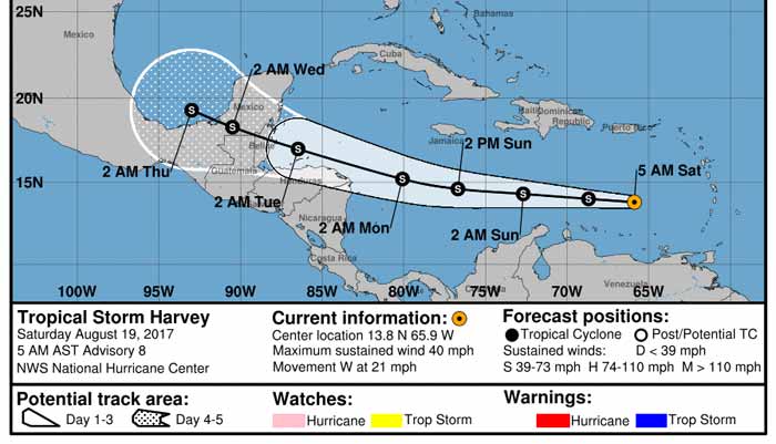
Navy track this morning, not much change.... ![[Linked Image]](//Ambergriscaye.com/art6/al092017dsdsdss.jpg) Wind shear continues to keep the system from intensifying significantly, but this will likely change some over the next day or two. Tropical Storm Harvey is located near 13.8N 65.9W at 19/0900 UTC, or about 243 nm south of St. Croix, moving west at 18 kt. Estimated minimum central pressure is 1005 mb. Maximum sustained wind speed is 35 kt with gusts to 45 kt. Harvey will continue to move westward at a quick pace over the next 12-24 hours, moving into a less hostile environment this weekend. Low wind shear and very warm water will likely aid in development. Additionally, Harvey should slow down in forward speed later today or Sunday, which will also contribute to further development. There are still many discrepancies with regard to the precise track early next week, and this will also play a role in the intensity forecast. A farther north track (north of Honduras) would favor a stronger system, while a southern track will lead to more land interaction and reduce the window for intensification. Right now, Harvey will most likely affect far northern Honduras and the Yucatan Peninsula by Monday or Tuesday.
|
|
|
|
|
Joined: Oct 1999
Posts: 84,398
|
|
OP
|
Harvey Will Move Across The Caribbean This Weekend With Tropical Storm Conditions Expected Across Honduras, Belize & The Yucatan Peninsula From Monday Through Tuesday
Tropical Storm Harvey:
5 am EDT/4 am CDT Statistics:
Location: 13.8 North Latitude, 65.9 West Longitude or about 235 miles to the east-northeast of Curacao.
Maximum Winds: 40 mph.
Minimum Central Pressure: 1005 Millibars or 29.68 Inches.
Forward Movement: West at a forward speed of 21 mph.
Satellite imagery and analysis of environmental conditions indicates that the center of Harvey is being exposed by northerly wind shear of 10 to 15 knots. Most of the thunderstorm activity is being pushed to the east of the center. It appears that the storm is relatively weak in strength and will probably remain weak until it reaches the western Caribbean on Monday. Once it reaches the western Caribbean, it is expected to find itself in a more favorable environment for intensification before it moves inland into Belize and the Yucatan Peninsula on Tuesday as a 50-70 mph tropical storm.
By about Thursday, Harvey is expected to move into the Bay of Campeche and its track beyond this is somewhat in question.
Everyone Across The Yucatan Peninsula, Belize & Northern Honduras: Tropical storm conditions, including up to 50 mph winds and heavy rainfall, are expected across northern Honduras on Monday and Monday night. For Belize and the Yucatan Peninsula, tropical storm conditions, including up to 60-70 mph winds, heavy rainfall and high surf, are expected to start after midnight Monday night and continue through Tuesday and Tuesday evening.
Model Track Forecast For Harvey:

Model Intensity Forecast For Harvey:

Satellite Imagery Of Harvey:

Crown Weather
For more information, check the daily Tropical Weather Outlook CLICK HERE.
|
|
|
|
|
Joined: Oct 1999
Posts: 84,398
|
|
OP
|
From Belmopan...
What does this look like to you. ?
A broken line of swell-ups or a Tropical Storm. ?
OK, it has time to reform before it gets to Belize, so keep watching.
1013 mb is normal pressure. 40 mph is hardly a storm, perhaps they keep quoting that figure, because 39mph or less is not even a Storm catagory.

|
|
|
|
|
Joined: Oct 1999
Posts: 84,398
|
|
OP
|
Wind Shear Rips into Tropical Storm Harvey
Tropical Storm Harvey, 92L Struggling, track remains steady: Time has not been kind to Tropical Storm Harvey, which entered the Caribbean as a minimal tropical storm on Friday. Hurricane Hunters were unable to find a closed circulation within Harvey at the 850 mb level (about a mile high) on Saturday morning. Because a closed circulation was found near the surface, the National Hurricane Center kept Harvey classified as a tropical storm at 11 am EDT Saturday. That may be generous, as no winds above tropical-storm strength (35 knots) were found at flight level by the Hurricane Hunters. Continuity may be a factor in keeping Harvey a tropical storm, since it is likely to move into a more nurturing environment later this weekend.
Located about 125 miles north-northeast of Curacao at 11 am EDT Saturday, Harvey was racing westward at 22 mph. Harvey's envelope of convection (showers and thunderstorms) had become much more fragmented and elongated, a byproduct of the storm's rapid motion coupled with persistently strong wind shear of 20-25 knots. It is possible Harvey will be stretched to the point where it loses its closed surface circulation and becomes an open wave by late Saturday. Assuming Harvey survives till Sunday, it will be moving into the western Caribbean, where wind shear is predicted by the 12Z Saturday SHIPS model to drop to the 5-10 knot range. Mid-level relative humidity should increase from around 50% to greater than 70%. This will give Harvey a much more supportive environment for strengthening. Sea-surface temperatures will remain quite warm along Harvey's path, around 29°C (84°F)-roughly 0.5°C above average. These warm waters are quite deep, providing ample oceanic heat content to enhance strengthening if Harvey does remain a tropical cyclone. The leading global models are in fairly good agreement on Harvey's general track over the next 3-5 days, but subtle shifts could make a big difference in Harvey's strength and long-term future. Most of the ensemble members from the 0Z Saturday runs of the GFS and European models take Harvey near or just north of the Honduras coast on Monday, with a landfall late Monday or Tuesday in Belize or Mexico along the east coast of the Yucatan Peninsula. A few ensemble members bring Harvey into far northern Nicaragua or eastern Honduras, in which case Harvey would likely weaken and might never reach the Yucatan. The official NHC forecast from 11 am EDT Saturday tracks Harvey into Belize as a strong tropical storm on Tuesday morning.
Jeff Masters / Category 6
For more information, check the daily Tropical Weather Outlook CLICK HERE.
|
|
|
|
|
Joined: Oct 1999
Posts: 84,398
|
|
OP
|
Harvey weakens to a tropical depression
The National Hurricane Center (NHC) is reporting that Harvey has weakened to a Tropical Depression. The center of Harvey is located near latitude 14.1 North, longitude 70.0 West, moving toward the west near 22 mph (35 km/h) and this general motion is expected to continue through Sunday. A turn toward the west-northwest is expected Sunday night or Monday.
On the forecast track, the center of Harvey will move across the central and western Caribbean Sea through Monday. Maximum sustained winds are near 35 mph (55 km/h) with higher gusts. Some slow strengthening is possible during the next couple of days, and Harvey could regain tropical storm status Sunday or Sunday night.
There are no coastal watches or warnings in effect.
|
|
|
|
|
Joined: Oct 1999
Posts: 84,398
|
|
OP
|
Tropical wave that was Harvey looking better organized
Showers and thunderstorms have increased this morning in
association with the remnants of Harvey. Gradual development of
this system is possible, and it could become a tropical cyclone
once again as it moves west-northwestward across the central and
northwestern Caribbean Sea during the next couple of days.
Interests in northern Nicaragua, Honduras, Belize, and the Yucatan
peninsula should monitor the progress of this system. An Air Force
Reserve reconnaissance aircraft is scheduled to investigate this
disturbance later today.
* Formation chance through 48 hours...medium...50 percent
* Formation chance through 5 days...medium...60 percent
A good deal of convection has developed around Harvey this morning, indicating that it might be regaining organized tropical characteristics. Tropical Rainstorm Harvey is approximately 250 miles south-southwest of Port-au-Prince Haiti and continuing west at about 16 mph. Harvey may become a tropical depression or tropical storm before it makes landfall by Tuesday morning in the Yucatan Peninsula.
Heavy rainfall with flooding and mudslides can be expected across northern portions of Honduras by Monday, as well as the Yucatan Peninsula on Tuesday. Depending on the degree of strength, there can also be damaging winds as Harvey approaches. This can lead to power outages and damage to weak structures.
|
|
|
|
|
Joined: Oct 1999
Posts: 84,398
|
|
OP
|
Harvey Will Move Into The Western Caribbean On Monday & Will Impact Honduras, Belize & The Yucatan Peninsula From Monday Night Through Tuesday
Remnants Of Harvey: After completely falling apart yesterday and being downgraded to a remnant storm, satellite imagery indicates that the shower and thunderstorm activity associated with Harvey is increasing this morning. This is likely because Harvey has moved from an area of stronger wind shear that plagued it yesterday into an area of lower shear this morning. In addition, analysis of environmental conditions across the western Caribbean indicates that the shear levels remain at least marginally favorable for the next couple of days. Given the increase in thunderstorm activity and the fact that the environment should be favorable enough for development, I think that we will see Harvey spin up again into a tropical storm between now and Monday evening. This means that tropical storm conditions can be expected across the southern Yucatan Peninsula, Belize and northern Honduras on Monday night into Tuesday.
Harvey is then forecast to cross the Yucatan Peninsula during the day on Tuesday and emerge in the Bay of Campeche on Wednesday and this is when its future track becomes questionable. At this point, I still think we are looking at a final landfall somewhere between Tampico, Mexico and Brownsville, Texas on Friday as probably a tropical storm or very possibly a hurricane. With that said, I still urge everyone along the coast of eastern Mexico and along the lower and middle Texas coast from Veracruz, Mexico to Matagorda Bay, Texas to keep a close eye on the progress and track of Harvey.
Everyone Across The Yucatan Peninsula, Belize & Northern Honduras: Tropical storm conditions, including up to 50 mph winds and heavy rainfall, are expected across northern Honduras on Monday and Monday night. For Belize and the southern Yucatan Peninsula, tropical storm conditions, including up to 60 mph winds, heavy rainfall and high surf, are expected to start after midnight Monday night and continue through Tuesday and Tuesday evening.


Crown Weather
For more information, check the daily Tropical Weather Outlook click here.
|
|
|
|
|
Joined: Feb 2004
Posts: 2,208
|
|
|
Harvey knew those bears were watching.
|
|
|
|
|
Joined: Oct 1999
Posts: 84,398
|
|
OP
|
From Belmopan...
As expected, TS HARVEY has overnight, intensified. I still do not see any rotation, but certainly a lot of ITCZ type swell-up intensification. It also appears to be pushing that high level cloud that was going up over Cuba, more our way, causing some rain out at sea and isolated areas of rain on land. Harvey is acting rather like an intense Tropical Wave, not a tropical storm. The rotating air has moved more west and now over the gulf, some of its NW wind is clashing with the high level from the SSW and is causing rain over and near Belize.
This storm has not been so much about sea temperatures, but more about will it rotate or not.
I have not been seeing any significant rotation, but a bunch of intense ITCZ type swell-ups.
I try to say it as I see it, but at the same time, we have to be prepared and ready, in case it does things I have not seen and intensify into some form of damaging storm.
The present indication is little or no wind, but could be dangerous flooding rains.
What I have been noticing with Weather reporting over this Storm and the previous one, is that many weather sites and individuals keep saying or quoting the normal expected things and actions and developments.
My neighbour has boarded up his windows, because of the warnings. The previous storm had all sorts of strong warnings, despite what I was seeing and saying. This storm, I have not seen much typical Tropical Storm with it, which I have been saying all along. The trouble with weather people saying terrible warnings is people do the wrong preparation, and after two storms in a row with no wind, then tend to not be prepared to handle a real dangerous storm. Each Storm is different, with different actions, risks and dangers. We need to be told what each different storm might do and what their different dangers might be, even whilst hoping for the best, but be prepared for the worst. This is what I have been trying to do.
This Harvey may well bring a lot of rain to parts of Belize, or even most of Belize, there could be serious flooding, but I am not expecting strong winds, except ITCZ heavy rains can often cause their own local very strong wind or micro-bursts.
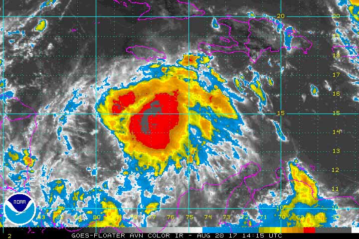
This is how Harvey developed over night and into this morning
|
|
|
|
|
Joined: Oct 1999
Posts: 84,398
|
|
OP
|
Ex-Harvey May Regenerate
Ex-Harvey is likely to regain tropical storm status at some point in the week as it heads west to west-northwest through the Western Caribbean, across the Yucatan Peninsula, then into the southern Gulf of Mexico's Bay of Campeche. Satellite images on Sunday morning showed that Harvey was beginning to reorganize, with a decent-sized area of heavy thunderstorms that were increasing in intensity and organization. Wind shear was moderate, 10 - 15 knots, the atmosphere had a not-terrible-for-development mid-level relative humidity of 55 - 60%, and the ocean was warm, with sea surface temperatures (SSTs) of 28.5°C (83°F.) An Air Force hurricane hunter aircraft will investigate the system on Sunday afternoon to see if a closed surface circulation is forming. The atmosphere will grow moister and the SSTs will grow warmer as ex-Harvey progresses to the west. None of the 0Z Sunday operational runs of our three reliable global models for predicting tropical cyclone genesis-the GFS, European and UKMET models-developed the system before it made landfall on Tuesday morning in Belize. However, the UKMET and European model predicted development of ex-Harvey back into Tropical Storm Harvey by Wednesday, when the storm is forecast to be in the southern Gulf of Mexico's Bay of Campeche. In its tropical weather outlook issued at 8 am EDT Sunday, the National Hurricane Center gave ex-Harvey 2-day and 5-day odds of development of 50% and 60%, respectively. Regardless of development, northern Honduras, northern Guatemala, Belize, and portions of Mexico can all expect very heavy rains in excess of four inches from ex-Harvey, which will likely cause dangerous flooding and mudslides.
Jeff Masters / Category 6
At 12 p.m. local time, Showers and thunderstorms are showing some signs of organisation in association with the remnants of Harvey, but it is still unclear if the system has a closed circulation. Gradual development of this system is possible, and it could become a tropical cyclone once again while it moves west-northwestward across the northwestern Caribbean Sea and the Yucatan Peninsula during the next couple of days. Interests in northern Nicaragua, Honduras, Belize, and the Yucatan Peninsula should monitor the progress of this system. An Air Force Reserve reconnaissance aircraft is currently en-route and should provide a better assessment of the structure of this system. As a result, the National Meteorological Service of Belize and the National Emergency Management Organisation (NEMO) will continue to monitor the progress of the remnants of Harvey.
For more information, check the daily Tropical Weather Outlook click here.
|
|
|
|
|
Joined: Oct 1999
Posts: 84,398
|
|
OP
|
Data from an Air Force Reserve Hurricane Hunter mission earlier
this afternoon indicated that the remnants of Harvey, located over
the central Caribbean Sea, do not have a well-defined center of
circulation. In addition, the associated shower and thunderstorm
activity remains disorganized and has decreased in coverage and
intensity since earlier in the day. Gradual development of this
system is still possible through Monday night while it moves
west-northwestward at 15 to 20 mph near the coast of Honduras, and
it could become a tropical cyclone again before it reaches the coast
of Belize or the Yucatan Peninsula early Tuesday.
|
|
|
|
|
Joined: Oct 1999
Posts: 84,398
|
|
OP
|
Last night it appeared the storm was reforming and rotating. It had developed a clear centre. This type of storm tends to redevelop at night time.
However, this morning it looks broken up again.... Looks like it will brush along the north Honduras coast and come into Belize, Monday evening into Tuesday morning. I am not sure about this, but with total lack of information from any of the proper weather channels, I am suggesting being more cautious and prepared.
A trough of low pressure, associated with the remnants of Harvey,
continues to produce a large area of disorganized showers and
thunderstorms over the northwestern Caribbean Sea. The remnant circulation of Harvey is analyzed as a 1007 mb low
along the wave axis near 15N80W. Scattered moderate to isolated
strong convection is from 14N-21N between 78W-86W. Gradual
development of this system is still possible through Monday night
while it moves west-northwestward near the coast of Honduras. It
could become a tropical cyclone again before it reaches the coast
of Belize or the Yucatan Peninsula early Tuesday. The remnants are
expected to move into the Bay of Campeche on Wednesday, where
redevelopment appears more likely due to more favorable upper-
level winds. Regardless of development, locally
heavy rainfall and gusty winds are likely to spread westward across
northern Nicaragua, Honduras, Belize, and the Yucatan Peninsula
during the next couple of days. The Air Force reconnaissance
aircraft mission scheduled for today has been canceled..
will keep watching....

|
|
|
|
|
Joined: Oct 2001
Posts: 6,267
|
|
|
The more I read these forecasts the more I think of baseball where there are tons of stats, lots of waiting and generally only sporadic action. We weather junkies love out stats on the past - lower barometric pressure ever, analog years activity ..... then when the game is on we launch into whats doing now and then what might happen if other things we don't know much about happen and what might occur if other things happen that we think we know about. then % odds are posted and the public places bets by boarding up, leaving or staying.
As for today - I'm watching the pitcher.
|
|
|
|
|
Joined: Oct 1999
Posts: 84,398
|
|
OP
|
amen sister. these storms are not about the past. They are about NOW.
|
|
|
|
|
Joined: Oct 2003
Posts: 2,461
|
|
|
Just about the take the Ouiji board out. At Chaa Creek. Do I stay or do I go? Go.....
|
|
|
|
|
Joined: Oct 1999
Posts: 84,398
|
|
OP
|
From Belmopan...
Quite a well-up over Roatan.

The band of rain that came across Belize last night was associated with Potential TS HARVEY and there is much more rain to come from it. The next band of rain is presently out at sea, over Roatan island, but could arrive over Belize later this morning, this is the sort of centre of the storm. It looks as if it will hit Belize between Dangriga and Monkey River, but then there are other swell-ups bringing rain later, for central and northern Belize over Monday and Tuesday. Although I am seeing significant rotation in the overall storm system, I am not seeing any high winds in the general centre area. It is still looking more like a collection of ITCZ type swell-ups, with others covering the whole of the western Caribbean, right up to the Yucatan.
Looks like today will be very patchy, rain, cloud, some sun occasionally. Flooding is a risk.

|
|
|
|
|
Joined: Oct 1999
Posts: 84,398
|
|
OP
|
From Belmopan...
The weather people on REMNANTS OF HARVEY which is more than disappointing that they are no longer tracking this storm, because it has the ability to cause significant damage to property and even life, through possible serious rainfall and flooding.
I have been trying to figure out why they are not still reporting this storm.
The best excuses I can figure out are :
1) It is not a threat to any part of the USA
2) They have already got the Named storm number up, when they named it a week ago, pretending it was a Tropical Storm, when it has never been a proper Tropical Storm, with Rotting winds of over 39 mph.
It has been a very odd storm, a group of ITCZ type swell-ups moving together, through the Caribbean, at present the there is significant rotation of the whole mass of clouds, but not a central rotating core.
But that is no excuse for the Belize Met Office for not advising us on their Storm Tracking what is happening.
And even less of an excuse for NEMO not to be on top of what is about to happen.
Lets just hope that there is not the amount of rain that this collection of storms could, theoretically produce.

|
|
|
|
|
Joined: Oct 2001
Posts: 6,267
|
|
|
Just about the take the Ouiji board out. At Chaa Creek. Do I stay or do I go? Go..... With the risk of flooding I'd say get out of Cayo now unless you want an excuse to stay a while ....... could be difficult to navigate Western Highway tomorrow.
|
|
|
|
|
Joined: Oct 2001
Posts: 6,267
|
|
|
Can we please order up enough storm to kill the mosquitoes? They are swarming beyond anything I can recall. I'll trade a few high waves and a power outage for relief from these guys.
|
|
|
|
|
Joined: Oct 1999
Posts: 84,398
|
|
OP
|
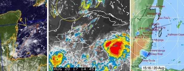
Crown Weather: Remnants Of Harvey Located Over The Northwestern Caribbean: The remnants of Harvey is pushing into the northwestern Caribbean and is expected to cross the Yucatan Peninsula during the day on Tuesday before moving into the Bay of Campeche on Wednesday. Satellite imagery indicates that there is deep thunderstorm activity firing around Invest 92-L, however, this thunderstorm activity is disorganized. The reason why the thunderstorm activity is disorganized is due to the fact that there is 20-30 knots of shear located just north and east of Invest 92-L and this stronger shear is likely not allowing Harvey to organize more than what's trying to right now. There is still a possibility that Harvey could regenerate before it reaches Belize and the southern Yucatan Peninsula on Tuesday, however, I think that there is a greater chance that the marginally favorable environmental conditions wont allow for regeneration over the next 24 hours or so. The remnants of Harvey will produce very heavy rainfall leading to flash flooding and mudslides across the Yucatan Peninsula and Belize starting this afternoon and continuing through tonight and Tuesday. In addition, wind gusts of up to 40-50 mph and rough seas can also be expected across Belize and the Yucatan Peninsula this afternoon through tonight and Tuesday. I don't think we will see Harvey become a tropical storm again until it reaches the Bay of Campeche on Wednesday. ![[Linked Image]](https://Ambergriscaye.com/art6/belmopanwx1708021b.jpg) ![[Linked Image]](https://Ambergriscaye.com/art6/belmopanwx1708021c.jpg) For more information, check the daily Tropical Weather Outlook: click here
|
|
|
|
|
Joined: Oct 1999
Posts: 84,398
|
|
OP
|
At 12 p.m. local time, Shower and thunderstorm activity has increased today in association with the remnants of Harvey, but the system still lacks a well-defined center of circulation. Some development of this disturbance is still possible before it reaches the coast of Belize or the Yucatan Peninsula early Tuesday. Regardless of development, locally heavy rainfall and gusty winds are likely to spread westward across Honduras, Belize, and the Yucatan Peninsula during the next couple of days. The possibility of flash-flooding and localised flooding continues to be a threat and residents in Belize are advised to monitor the progress of this system closely and to stay tuned to official updates from NEMO and the National Meteorological Service.
|
|
|
|
|
Joined: Oct 1999
Posts: 84,398
|
|
OP
|
NEMO Advisory #2 :REMNANTS OF TROPICAL STORM HARVEY APPROACHING BELIZE
The National Emergency Management Organization in collaboration with the National Meteorological Service hereby informs the public that remnants of Tropical Storm Harvey is expected to cross over the country tomorrow Tuesday 22 August, 2017. There is still a chance for redevelopment before it reaches our coastline. We can expect wind gusts, heavy rainfall and squally conditions.
The public is advised to take actions to protect life and property. If you are exposed to bad weather conditions make the necessary arrangements to lessen the impact on your home and family.
Fishers and seagoing members of the public are advised to take the necessary precautions to reduce injury and loss of life.
Farmers are encouraged to attend to their crops and animals to reduce losses.
Drivers are always reminded to drive with extreme caution.
|
|
|
|
|
Joined: Nov 2000
Posts: 5,563
|
|
|
Raining on and off sometimes hard, sometimes drizzle. Wind blasts then abates. The sky is very grey and low. Seems pretty cool but mosquitos are bad!
Harriette
Take only pictures leave only bubbles
|
|
|
|
|
Joined: Oct 1999
Posts: 84,398
|
|
OP
|
Shower and thunderstorm activity has increased today in association
with the remnants of Harvey, but the system still lacks a
well-defined center of circulation. Some development of this
disturbance is still possible before it reaches the coast of Belize
or the Yucatan Peninsula early Tuesday. The system is forecast to
move into the Bay of Campeche early Wednesday, where environmental
conditions are expected to be conducive for redevelopment into a
tropical cyclone.
Regardless of development...the wave will continue across the NW Caribbean
Sea waters and portions of Central America through tonight into
early Tuesday morning and move across the Yucatan peninsula
Tuesday. Largest impacts at this point will be the expected
rainfall and strong convection the wave and low pressure area will
generate across interior portions of eastern Honduras...
Guatemala...Belize...southern Mexico...and the Yucatan peninsula
Monday night into Tuesday. In addition to the expected
rainfall...a higher probability of flash flooding and mudslides
will be an ongoing hazard across this region early in the week.
|
|
|
|
|
Joined: Oct 1999
Posts: 84,398
|
|
OP
|
Latest satellite view....

|
|
|
|
|
Joined: Oct 1999
Posts: 84,398
|
|
OP
|
From Belmopan...
It looks as if the heavy rain was out at sea this morning, reduced as it got to land, so there has not been heavy rain in most parts of Belize. Now most of the remaining rain is going up into the Yucatan. It looks as if the worst of it is now finishing over the next hour or so. The general area of activity has been mainly developing northwards, resulting a general movement now WNW and up over the Yucatan. We may well have significant cloud for a day or two and some more rain, but the worst appears to have now passed Belize.

|
|
|
|
|
Joined: Oct 1999
Posts: 84,398
|
|
OP
|
At 3 a.m. local time, the area of disturbed weather remains disorganized.
Note that lingering moisture and instability over Belize will support showers and deeper convective / thunderstorm activity during the next day or two.
- Previously, At 12 a.m. local time, satellite images showed that the large area of disturbed weather over the northwestern Caribbean
Sea, associated with the remnants of Harvey has not become
better organized and tropical cyclone development is not expected
before the system moves inland over the Yucatan peninsula this
morning. However, environmental conditions are expected to be
conducive for development when the system moves over the Bay of
Campeche tonight or early Wednesday, and a tropical depression is likely to form over the southwestern Gulf of Mexico on Wednesday or
Thursday. Regardless of development, locally heavy rainfall and gusty winds are expected to spread westward across Belize and the Yucatan peninsula during the next day or so.


TS Harvey Dissipates, Will Dump Rain On Belize, Yucatan
 Tropical Storm Harvey had everyone on edge last week. Many people were pretty much preparing for the worst because Friday's weather report had stated that the storm was moving west at 21 miles per hour with maximum winds of 40 miles per hour. So if you were wondering what happened to Harvey, well over the weekend the storm dissipated and it is now only a tropical wave. But don't get happy too fast, this wave will still bring a lot of rain. In fact, the showers started this afternoon and according to Acting Deputy Chief Meteorologist Derrick Rudon, the rains will continue later on tonight and tomorrow morning. Here is Rudon with more on the Tropical wave formerly known as Harvey.
Derrick Rudon, Acting Deputy Chief Meteorologist
 "Harvey was heading towards Belize basically all the forecast was pointing it directly at us fortunately it dissipated over the South Central Caribbean and it is down now to a Tropical wave so at present the remnants of Harvey is still heading towards us."
"We will still be affected by it, we will get rains definitely and gusty winds in the showers."
Courtney Weatherburne, reporter
"What areas? I overheard you guys saying mostly in the South, people in the South are already being affected?"
Derrick Rudon, Acting Deputy Chief Meteorologist
"Well it is going to be the whole country the coast at first, we expect Northern areas this afternoon and possibly the South tonight so the whole country will get rain and we know the south floods easily they tend to have flash flooding but all areas can expect heavy rainfall and some low lying areas there is the possibility of flooding."
Again those living in low lying/flood prone areas need to be on the alert.
Channel 7
|
|
|
|
|
Joined: Oct 2001
Posts: 6,267
|
|
|
My dog is more anxious today than during the thunder ........ wonder what he's picking up on.
|
|
|
|
S |
M |
T |
W |
T |
F |
S |
|
|
1
|
2
|
3
|
4
|
5
|
6
|
|
7
|
8
|
9
|
10
|
11
|
12
|
13
|
|
14
|
15
|
16
|
17
|
18
|
19
|
20
|
|
21
|
22
|
23
|
24
|
25
|
26
|
27
|
|
28
|
29
|
30
|
|
|
|
|
|
|
0 members (),
186
guests, and
0
robots. |
|
Key:
Admin,
Global Mod,
Mod
|
|
|
Forums44
Topics79,205
Posts500,031
Members20,471
| |
Most Online7,413
Nov 7th, 2021
|
|
|
|


![[Linked Image]](http://Ambergriscaye.com/art6/144536_earliest_reasonable_toa_no_wsp_34.jpg)


![[Linked Image]](http://Ambergriscaye.com/art6/al092017dsdsdss.jpg)


