 Tropic Air is not able to fly a regular schedule today but will be running
a full schedule tomorrow barring further inclement weather. Holiday Hotel
will open on a limited basis on Sunday and fully shortly thereafter.
Tropic Air is not able to fly a regular schedule today but will be running
a full schedule tomorrow barring further inclement weather. Holiday Hotel
will open on a limited basis on Sunday and fully shortly thereafter.
The Deputy Prime Minister is asking that Tourists follow through with their plans to visit the country.
It would be a good idea for hotels, airlines, and tour companies to contact their guests and inform them that the damages are and that they should follow through with their travel plans.
|
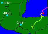
Friday Evening 10pm Surface data and satellite pictures suggest that the surface center is now over central Honduras and moving toward about 250 degrees near 6 kt. While numerical models have shown an eventual breakdown in the high to the north for some days...the 18z avn now indicates that change should take place within the next 48 hours. If correct ...And if Mitch survives that Long...then Mitch could be pulled toward the nw or north. The track forecast is based on that progression and is similar to the track model guidance. Heavy rainfall and the potential for floods are likely to persist for at least another 24 to 48 hours over portions of Honduras... nicaragua...guatemala...belize...el Salvador...and the Yucatan Peninsula.
There is some possibility that tropical storm warnings could eventually be required for the
Pacific coast of some of the above mentioned areas.
    forecast positions and max winds
initial  31/0300z 14.4n  87.3w  45 kts...inland
12hr vt  31/1200z 14.5n  88.1w  40 kts...inland
24hr vt  01/0000z 14.7n  89.1w  30 kts...inland
36hr vt  01/1200z 15.4n  90.2w  30 kts...inland
48hr vt  02/0000z 16.1n  91.2w  30 kts...inland
72hr vt  03/0000z 18.0n  92.0w  30 kts...inland
Click here for images of tracking path and weather map |
FOLLOW ALL YOUR PLANS, COME TO BELIZE. Our wild life is intact and more alive than before, our forests are greener, there has been a lot of water for them. Our great mayan temples are drying up for you to climb and photograph them. Our cayes are opening their doors to receive you as the sea is abating to a tamed, tranquil, shallow, blue barrier reef ( a world heritage) filled with friendly marine life.
We thank you all for your good wishes, and prayers. We were all heard. There has been absolutely no report on loss of life ( thank you all) and very little loss in material things. We were prepared for the worst all over the country.
We thank our Government of Belize, We thank Patty Arceo for inspiring confidence in us, We thank the Weather Channel, We thank our local radio stations, and We applaud for ourselves. We prepared ourselves, and the Lord helped us. When you all visit us, you will hear interesting anecdotes from the critical moments that Mitch made us pass through. There was love, kindness, sharing and solidarity never before put to the test. There was fun in the mass exodus from the coast and cayes, in our villages, etc. Visit My Tropical Page to convince yourself that it is time for you to come to Belize!! http://www.geocities.com/thetropics/cabana/4764 For God, People, and Country
G.Rosado JP BS
He says conditions then were fair to good. High water yet, but he was able to walk out onto the pier which was at water level. Lots of trash piled up against the front of the resort building with some water in on the floors. He said the river, then, was right at flood stage, and any appreciable amount of rain would put it over the banks.
He was able to walk to his office building which is down near the antenna
tower and everything was fine there. He said the max winds were around 35
mph and didn't believe there was much wind damage, at least from what he
could see.
Ray
Thank you sir, and thank you for the infomation about your family and from Dangriga. I have learned much from your son, he is a master photographer and a master programmer, as you probably know. He has skills above those of mortal men.
I am very glad everyone is safe and I will post the info on the site. I hope it doesn't rain too much, and the folks can get down from out of the west before the rains hit too hard.
Its been a wild one,
Marty
There has been no rain at all for the past 4 hours!! Satilite maps show a "no-show". I think we can put Mitch to Bed for Northern Belize.
People were allowed to return from the shelters today in Corozal.
On Caye Caulker Sobre Las Solas, Other Side of the Moon, Popeye's, Oceanside don't know if they can open)
Rainbow Bar and Restaurant. The building broke in two and is in the path in front of the hotel.
( This is down by the main dock) -SandBox is apparently okay and I understand he opened. He lost the sea wall in front and beach, but the building is okay. If you walk down the middle street you would think nothing happened here. Driftwood tour shop on the corner opposite Belly Martinez's is gone, you'll find it in the middle of the street going to the football field, and now it is facing west! The football field is filled with the worst muck and garbage you can imagine. you have to wade thru such muck and horrible stuff. Frenchie's new building on his new dock is GONE! Annie saw it go into the sea. That was some big building. Now most of it is in front of Neil's place, his deli, hardware and home! They won't be able to walk up to their place!!
You can't walk down the front of the Caye, you are in the sea and you have to climb over docks, broken buildings, etc. The entire north end will have no electricity for a long time.
I can't walk to Tom's Hotel!(Tom Young) You have to climb over docks, junk, etc. and then you get to Paolo's house and have to scrutch down and walk under the middle of the house and at that you are mostly in water. When you come out on the south side of the house, you have to be careful since you are in a nest of coconut tree roots which are all exposed. A lot of standing water , a mixture of salt and rain. You can hear the sea pounding in and we still have storm surge. Waves are also breaking under Terry Anderson's house. Tom has no beach to speak of in front of the hotel and a HUGE pile of stuff in front of the hotel.
Aunt Nils (She lives right in front of the school) has a BIG lake in front of her house and it extends right up to the church door. It starts just in back of Terry Anderson's house.
I have no idea what the back is like but from what I could see when walking down the middle street, there is water up the cuzoo! Naturally the back would be flooded too.
Well, its not a pretty picture, Village Council (Fermin) said if they got him the right kind of machines, he could clean the whole Caye, and it would take about two months. I wish I could send the pictures now instead of having to go snail mail when and if mail service is restored. The only usable dock is the back bridge and no planes are coming in and out.
Thanks again! Isn't the computer age great, and love the e-mail
Radio reports from Honduras and Nicaragua indicate massive loss of life from flooding. The bay island of J....... (forgot the name) has only two concrete houses left standing.
Later, when you get out of the water, the needles return briefly then are followed by a burning that eventually goes away.
The weakening storm could cause more trouble in Central America over the next several days if it moves back out over open water, and flooding remains a problem throughout the region, but it appears that the Caribbean Coast of Guatemala, Belize and Mexico have avoided severe damage from what was once the fourth most-powerful hurricane ever recorded.
As of Friday evening, Mitch's winds had dropped to about 40 miles per hour. The storm remained over the North Coast of Honduras.
The National Hurricane Center in Miami said Friday the storm was centered about 45 miles south of La Ceiba and drifting west-southwest at 3 mph. Maximum winds were around 40 mph, down from 180 mph on Tuesday, but some forecasters say the storm could regain strength over open waters by Monday. Forecasting for this storm has been notably poor, however, according to some observers.
According to some reports, at least 14 have died on the island of Guanaja, one of the Honduras Bay Islands, and most houses were leveled by the storm. As many as 50 people were missing in the city of Comayagua in central Honduras after the Salistroso River swept away 150 houses. In coastal Santa Rosa de Aguan, at least 25 people were thought to be dead due to floods.
No deaths have been reported in Belize.
The death toll in Honduras, where up to 50 inches of rain fell, is likely to rise as more reports come in from areas isolated by swollen rivers, downed telephone lines and closed roads.
Significant property damage is reported on the Honduras Bay Islands and in mainland Honduras. In Belize, the damage has been mostly limited to the loss of docks, a few seafront buildings and beach erosion along the coast and on the cayes. Inland flooding in Cayo and elsewhere was a problem on Thursday and Friday. Beaches on the Placencia peninsula and around Hopkins have had some erosion. Full reports from remote cayes are not yet available.
Residents and visitors on the Caribbean Coast of Guatemala, Belize and Mexico still are waiting to see what Mitch will do, according to live reports via the Internet and telephone and from weather and news services. Some computer models forecast that the seriously weakened storm might move back out to sea, picking up some power over water and make landfall again around Chetumal, Mexico, before moving through the Yucat½n peninsula. Other observers felt it more likely the storm would dissipate itself in Honduras and Nicaragua.
Unless Mitch regroups and moves out to see as a reborn hurricane, the biggest remaining threat to Belize is flooding from its many rivers and from heavy rains from the remnants of Mitch, which could total an additional 10 to 25 inches.
Belize commuter airlines likely will begin service again over the
weekend, weather permitting. International airlines are waiting to see
what Mitch may do before bringing in their equipment.
Lan Sluder, Belize First Magazine
Mitch taught us a lesson. It enable us to seek God, friendship, kindness, solidarity, love, strenght from within, etc. It revealed to us harsh reality. Proverbs were well proven, you name them: "A bird in the bush is worth two in the hand" , "God helps those who help themselves", " Early bird catches the worm", "It is better late than never", "Make hay while the sun shines", " A prepared man has the value of two" etc..
I would like to tell you are welcomed any day you set foot on our soil. I am speaking for all Belizeans who possess a Belizean heart and mind. Come to my village any time. I felt very happy when I received your message. I want to tell you, that we did not see anything of Mitch around our village except the flooded river and a gust of wind which scared the soul of the whole village, after that, it all boiled down to fishing. I believe you know that when the river floods it is easier to catch the bigger fishes. Well, everyone happily went fishing after Mitch. I know that you should visit the Mayan temple in my web page. After you posted my report on your site the massive downpour of strengthening and inspiring messages I received was more than Mitch could handle, thank you.
We were all conscious of the impact and ramifications that a category 5 hurricane would have had on our lives. Hence, it was discussed over and over around the river banks, in the bus, at the bank in town, etc. Plenty of the "refugees" from the islands, coastal towns and villages left the main center of the country,our beloved Cayo District, to their homes. You may take a look at my webpage to know exactly where and what I am speaking about. Hurricane shelters such as churches, schools, community centers were sadly abandoned by their guests. The Belize River. Mopan River and Macal River are flooded but within normal proportions.
A category 5 hurricane would have demolished, destroyed, and devastated our hearts, commumities, country, life, and all that we are and offer to the world. We are a very small country that lives off eco-tourism, orange trees, sugar cane, bananas, rice, vegetables, fruits, fishes, lobsters, marine exports, livestock, and true, real, human hospitality. All of the above are in some way or the other affect by any category of a hurricane. We thank the Lord and all the people who prayed for us. Our hearts are with the people of Honduras. We are at this point assessing damage suffered so as to be able to offer help and assistance to our brothers and sisters in Honduras
...Heavy rain and flash flood threat continues over portions of central America...
tropical storm warnings remain in effect for the caribbean coast of Honduras...guatemala...belize...and the Yucatan Peninsula of Mexico from Cabo catoche southward...including the offshore islands. Small Craft in the warning areas should remain in port.
At 7 pm EST...0000z...the center of Tropical Storm Mitch was estimated from satellite pictures and surface observations in Honduras to be located near latitude 14.5 north...longitude 87.0 west. This position is over central Honduras about 35 miles...55 km...North-Northeast of tegucigalpa.
Mitch has been moving toward the West-Southwest near 6 mph... 9 km/hr...and this general motion is expected to continue through tonight.
Maximum sustained winds are near 50 mph......85 km/hr...with higher gusts. The Island of roatan off the coast of Honduras reported sustained winds near 45 mph about two hours ago. Slow weakening is forecast.
Tropical storm force winds extend outward up to 200 miles ...325 km...mainly over the water to the north of the center.
The estimated minimum central pressure is 1000 mb...29.53 inches.
Additional rainfall totals of 15 to 25 inches are possible over portions of Honduras and nicaragua...with lesser amounts over portions of belize...guatemala...el Salvador...and the Yucatan Peninsula. These rains could cause life-threatening flash floods and mud slides...especially in association with higher terrain.
Repeating the 7 pm EST position...14.5 n... 87.0 w. Movement toward...West Southwest near 6 mph. Maximum sustained winds... 50 mph. Minimum central pressure...1000 mb.
About the elctricity, only the south end has electricity, north end has none. About 4 poles are down. Will be a few days before they are back up.
I spoke to my sister in law yesterday and she said all the piers were gone and bars or restaurants and dive shops that were up at the beach also.
All other buildings were still standing , but some had damages like zincs flown off the roofs.....
Flooding is the immediate danger for Belize from heavy rains. But if the center of low pressure starts to wind up again over open water, we will have another, at least Category 1 Hurricane within 4 days to worry about. Keep that in mind. If you get a chance to stock up with supplies Saturday and Sunday, be sure to do so. Better to be prepared than to be sorry.
Hopkins is cutoff with both bridges north and south out, on the
highways.
Ray Auxillou
tropical storm warnings remain in effect for the caribbean coast of Honduras...guatemala...belize...and the Yucatan Peninsula of Mexico from Cabo catoche southward...including the offshore islands. Small Craft in the warning areas should remain in port.
At 4 pm EST...2100z...the center of Tropical Storm Mitch was located near latitude 15.1 north...longitude 86.8 west. This position in inland over Honduras about 45 miles...70 km...south of la Ceiba.
Mitch is drifting toward the West Southwest near 3 mph... 6 km/hr ...And a mostly westward drift is expected for the next 24 hours.
A report from the Island of roatan off the coast of Honduras indicates that maximum sustained winds are near 60 mph... 95 km/hr...with higher gusts. This is higher than stated on the previous advisory...but some weakening is forecast tonight and Saturday.
Tropical storm force winds extend outward up to 200 miles ...325 km...mainly over the water to the north of the center.
The estimated minimum central pressure is 998 mb...29.47 inches.
Additional rainfall totals of 15 to 25 inches are possible over portions of Honduras and nicaragua...with lesser amounts over portions of belize...guatemala...el Salvador...and the Yucatan Peninsula. These rains could cause life-threatening flash floods and mud slides...especially in association with higher terrain.
Repeating the 4 pm EST position...15.1 n... 86.8 w. Movement toward...West Southwest near 3 mph. Maximum sustained winds... 60 mph. Minimum central pressure... 998 mb.
The Mopan River is still rising at noon on Friday and the ground is saturated up north, reports Peter.
The largest coastal town, could be cut off at the highways, as the Flood Peak is expected to travel downriver and hit the coastal community around noon on Saturday and extend through Sunday.
Further rainfall is expected and 15 inches more of rain will play havoc throughout the country. I guess that will cut off the Mennonites from the Western Highway system for a few days. I hope their ferry survives.
i'm down at the south end- not in the village, so my wind generators are giving me all the power i need to keep all my lines open. it usually would take me 5 minutes to get to the village, but with the trail out, it takes about half an hour-depending on the crocodiles.
beach front is a mess, but no major damage. piers are, of course, pretty much wiped out, but as far as buildings, all are fine- just a lot of cleaning up to do. lots of sand to move around. ray's property, like everyone's is still there. considering everything, we really lucked out here- just bring 2 brooms instead of one.
to my internet friends, tell them all is well with HAMARUBA
i'll check back in a while- i've got plenty of cleaning to do also
People are all beginning to believe that it is OK to come out!! I feel the real trouble is just around the corner. Just look at the satellite pics!! We have a very heavy load of rain trucking our way. Forcasts are telling us that it will come up the center of Belize -- splitting us into the "Four Kingdoms".
Southern Belize, Western Belize, Belize City and Northern Belize. Already businesses here are hurting. Yet as always -- another 48 hours before we even know when we can get back to work.
Flooding is a very real danger as the ground is saturated and all rain is now run-off.
If the last forecast is accurate, we'll be shopping in Chetumal -- a little more so than is usual.
Ray, the old boat is good for 5 tons -- eh?? Cause that may be the only way to shop in Chetumal come next Tuesday/Wednesday. Also, for those of you on the Northern Islands needing supplies in the near future -- now is the time to contact me for making arrangements. "Tzabcan" is ready to sail, with five tons, to any point.
Further, we have at least 6 more sail boats, same configuration, tied up in the upper lagoons, that can also be put on transport detail. Talk of turning the clock back!!
We can even make the run to Shipyard for chicken, beef, pork, eggs, rice,
corn, lumber and many other sundry items. Don't know when regular road
transportation will be clear if this sucker hits us!!
Peter Singfield [email protected]
It sounds like Monkey River is having some rough times. The last report we got though was good, Mitch is dying and could be gone in 24 hours. Of course the reports vary, but I like this one.
Now to focus on those hurting in Honduras. Oh, Barrios, Guat. was having 70mph
winds because of the trough that they are in with the Maya Mts and the Mts of
Honduras. They were having flooding there. Barrios floods in a drizzle so it is not a
surprise. But the wind is new to them. I will write again tomorrow.
God bless, Carol at Sea Port Inn, P.G
We have had a lot of rain and the road is probably not open to small vehicles because of flooding . This is not that unusual here. The international airport has reopened and we expect the local airlines will be back in service within a couple of days.
Nearly everyone is still evacuated because the road is so bad it is hard to get in. I could not reach anyone in Placencia who might know your friends but as people return in the next few days I will try to get a message to them for you.
Best wishes,
Kerry Goss, Owner of Blue Crab
Resort
Been trying to touch base with San Pedro but line keep busy so lots of planning must be going on. It has been raining in Belmopan for the last 3 hours straight and in about half an hour I will be heading to take a look at Roaring Creek.
He will be going out to Glover's Atoll for us as soon as it is safe.
If anyone wants to read a site similar to this one for Honduras, where the situation is much worse, you should go to http://www.honduras.com.
no, we are not under 4 feet of water. everything is fine. there were 135 of us on the caye until the the last bunch left and this island is the safest it's ever been.
Apparently passengers taken out Tues. on chartered flight. Yhis would leave
Capt. Guyan and crew.. approx.30.
I had a report that they were found, and in a port in HOnduras, but since nothing else has turned up to corroborate this, I am trying to recheck this information. Will keep checking, my source has not checked back, I have asked twice in 8 hours but they apparently haven't checked their email.
Will keep checking.
Marty
Marty
In the past we have found that Belmopan area peaks 12 hrs after cayo, and then an additional 12-24 hrs is required for the peak flood to reach the Belize district.
The Macal at the hydro has not risen since 10pm thursday. San Ignacio is affected by both the macal and the Mopan. The Mopan is still rising. Downstream of branchmouth (where the two rivers meet) at 12 noon today we are 22 ft above normal and rising. There is major flooding of farmlands. We have not seen the river this high since 1991. It is therefore likely that the Belize district will be very badly affected by flooding from mid-day tomorrow. If the' weather experts' are correct and we get another 15-25 ins of rain, there will be some serious flood damage.
tropical storm warnings remain in effect for the caribbean coast of Honduras...guatemala...belize...and the Yucatan Peninsula of Mexico from Cabo catoche southward...including the offshore islands. The hurricane watch for belize was discontinued at 10 am EST. Small Craft in the warning areas should remain in port.
At 1 pm EST...1800z...the center of Tropical Storm Mitch was located near latitude 15.3 north...longitude 86.5 west. This position is inland over Honduras about 35 miles...60 km...southeast of la Ceiba.
Mitch is drifting toward the West Southwest near 3 mph...5 km/hr. A slow mostly westward drift is expected for the next 24 hours.
Maximum sustained winds are near 40 mph... 65 km/hr...with higher gusts. Little change in strength is forecast today.
Tropical storm force winds extend outward up to 175 miles ...280 km...mainly over the water to the north of the center.
The estimated minimum central pressure is 997 mb...29.44 inches.
Additonal rainfall totals of 15 to 25 inches are possible over portions of Honduras...nicaragua...with lesser amounts over portions of belize...guatemala...el Salvador...and the Yucatan Peninsula. These rains could cause life-threatening flash floods and mud slides...especially in association with higher terrain.
Repeating the 1 pm EST position...15.3 n... 86.5 w. Movement toward...West Southwest near 3 mph. Maximum sustained winds... 40 mph. Minimum central pressure... 997 mb.
To this point Tropic Air will only carry out one more flight to Belmopan to pick up an emergency relief team and fly them over to San Pedro. Steve pointed out that they had strong winds flying over Orange Walk.
It is drizzling lightly in San Pedro and the winds have picked up to about 25knots from the North East.
Steve will keep us posted as will advise when it is clear for Tropic Air, other airlines and ferries to resume trips back to San Pedro.
1st, We have made it out of this storm . how i don't know but i'll take the break... unfortunately our neighbor Honduras took the fall for Belize this time..they are wiped out... there banana crop is lost as for many people who have died during this onslaught.....we hope to help if we can...Bob's wife is from Honduras.... she did have one of her sons at our place.....
2nd The storm is still very dangerous in the water it is putting out.. Coordinates N 15* 4. and W 86* 1, @ 40mph bearing from Monkey River @ 110 degrees..... Reported from Bob this am.: water level is high and has actually repaired our beach front... Minor structual damage to Bob's house.....This was NOT caused by the storm ,.....Bob ran out of beer on Tues...Seems his withdrawels prompted some minor tremor in the area..for a few days.. he has since replenished his Belikin and now we can finally take another step backwards. J.L. at the Monkey House is fine a well as the village itself.
3rd. to all of you that i might have kept waiting for a reply to
availability of our resort... Sorry but i was pretty sure we were going
down for the big one. please lets start up some communication and let's
see if we can make some vacation plans for you and yours.
E.J.
Belmopan 11:30 BT Fri.
Rec'd word that most people are back home from Belmopan. All praise is due to God for the safety of Belizeans. Our prayers are with our Honduran brothers and sisters. But it is NOT over. Heavy rain may still come to Belize. Belizeans should restock their water and food supply. Bathe, cleanup and prepare for cold rains. Check on the elderly and help your neighbors, especially if they don't have food and you have. Remember if you're uncertain about your water boil it before drinking and watch out for snakes. Don't walk bare- footed
The message was that the people remaining on the island are still in good spirits...much more so than those who went to the shelters and want to come home. The San Pedro Lions Club wants to determine what aid they can supply to their Honduran brothers, and are considering sending money and clothes as soon as more of their members return to San Pedro.
The current message is things are fine in San Pedro," we do not need a relief effort at this time"... " Thank everyone for their concern for the people of San Pedro and Belize." "People should send help to our Honduran brothers"
It is expected that the minor damages will be cleaned up in just a few days and the only reminder of Mitch will be a slightly changed shoreline and the absence of piers. In as little as a week the island will be ready to offer fishing, snorkeling, diving, and just plain old relaxing San Pedro style to its' visitors.
Those with travel plans to San Pedro are informed that they should proceed with their plans as there were no significant damage to buildings and Hotels are making preparations to open as soon as Sunday. International flights into Belize and flights to the island are expected to resume a normal schedule today. Check with your travel agent or directly with the airline and hotel to see if they will be open, then pack the sunscreen and tell your friends you're on your way to San Pedro Ambergris Caye!
Only possible holdup if the weather system continues to weaken is it is possible we run out of fuel for the diesel engines that provide electricity. Food no longer a big issue as the planes can fly in as soon as the Belize City warehouses open.
tropical storm warnings remain in effect for the caribbean coast of Honduras...guatemala...belize...and the Yucatan Peninsula of Mexico from Cabo catoche southward...including the offshore islands. Small Craft in the warning areas should remain in port.
At 10 am EST...1500z...the center of Tropical Storm Mitch was located near latitude 15.3 north...longitude 86.2 west. This position is inland over Honduras about 55 miles...85 km...East- Southeast of la Ceiba.
Mitch is drifting toward the West Southwest near 2 mph...4 km/hr. A slow mostly westward drift is expected for the next 24 hours.
Maximum sustained winds are near 40 mph... 65 km/hr...with higher gusts. Little change in strength is forecast today.
Tropical storm force winds extend outward up to 175 miles ...280 km mainly over the water to the north of the center.
The estimated minimum central pressure is 997 mb...29.44 inches.
Additonal rainfall totals of 15 to 25 inches are possible over portions of Honduras...nicaragua...with lesser amounts over portions of belize...guatemala...el Salvador...and the Yucatan Peninsula. These rains could cause life-threatening flash floods and mud slides.
Repeating the 10 am EST position...15.3 n... 86.2 w. Movement toward...West Southwest near 2 mph. Maximum sustained winds... 40 mph. Minimum central pressure... 997 mb.
"Message: No reason to believe that Cielos Azules (our house) suffered more than minor damage. The new road flooded but held. The beach road is covered with trash, logs and conch. It may take some time to clear the 10 km out to Cielos.
We returned late Thursday. There was very little damage on land. All piers in town were severely damaged or completely destroyed. There is no city electricity but there was no water damage in my house (in town.) I had moved my boats into the river and I don't know yet how they held. Your boat is OK behind Sylvia's.
The weather is still bad."
Thank you all for praying for us."
Armando
The Mennonites have been bringing in food from Spanish Lookout, though how they have been crossing the Belize River (I believe at their ferry is downstream of the confluence of the Macal and Mopan), I can't imagine. I have a coworker on the paper who is a Mennonite and I'll see if she can get detailed info.
Roaring Creek has flooded the Western Highway near the intersection of the Hummingbird Highway turnoff which will impede traffic returning to the big city. We had a decent little wind and rainstorm today. But I am hopeful that that will be it and the river will recede soon. The new, little bridge used to span our towns is way flooded, but the Hawkesworth (the old, high bridge which has been closed for repairs) is open. Still, going from my home in Sta. Elena to San Ignacio is a major traffic snafu requiring at least twenty minutes to get across. And Belizean drivers are in a class unto themselves -- that's as kind as I can be.
Heard a rumor they are still trying to evacuate people off the island.. but they are refusing. They figured if they made it this long.. Know some locals who are trying to return. Concerned about looting.
Orlando is fine, partying at I and I. South end is not accessible, except thru the old trail now a river, with matchettes for the crocodiles and mangroves.
Food is a problem, Ken seems really worn out, but glad he stayed to ward off possible looting and not to be locked in a shelter. He is geeting his e mail back up
Caye Caulker
No one has been able to telephone Caye Caulker since Monday last. The
phone system is dead. The Village Council were supposedly holding a 24
phone village emergency communication at their office. Telephone 011 501
222043
John Marin's phone, my neighbor behind me is at 011 501 222149 from the USA.
Tried both numbers but cannot get through to get any updates on the property or conditions since last Monday.
Perhaps someone knows a Police contact at Belmopan Police Department and they can contact the police station on Caye Caulker by radio. I understand that is working and get an update. Interested in my property and stuff and Wendy's trailer, etc. next to the park.
...Mitch remains inland over northern Honduras...heavy rain threat continues...
tropical storm warnings remain in effect for the caribbean coast of Honduras...guatemala...belize...and the Yucatan Peninsula of Mexico from Cabo catoche southward...including the offshore islands.
A hurricane watch is also in effect for the coast of belize. Small Craft in these areas should remain in port.
At 7 am EST...1200z...the center of Tropical Storm Mitch was located near latitude 15.4 north...longitude 86.1 west or about 50 miles ...X90 km...xx East-Southeast of la Ceiba Honduras.
Mitch has moved little over the the past several hours and little overall motion is likely the remainder of this morning. Mitch is expected to begin moving in a slow general westward direction later today.
Maximum sustained winds are near 40 mph... 65 km/hr... with higher gusts. Some further weakening is possible while the center of Mitch remains over land...but the storm could re-intensify if the center emerges from the coast.
Tropical storm force winds extend outward up to 175 miles ...280 km from the center...mainly over water.
The estimated minimum central pressure is 997 mb...29.44 inches.
Additional rainfall totals of 15 to 25 inches...with locally higher amounts...are possible over the mountains of Honduras and other parts of central America. These rains could cause life-threatening flash floods and mud slides.
Coastal flooding due to strong onshore winds and waves continues over portions of the tropical storm warning area.
Repeating the 7 am EST position...15.4 n... 86.1 w. Movement... nearly stationary. Maximum sustained winds... 40 mph. Minimum central pressure... 997 mb.
We talked to Hopkins yesterday and will do so again tomorrow. Everything sounded fine and pretty low-key there. Many residents went to Belmopan, but many also stayed. they did not sound particularly worried.
We run kayak trips at Glover's Reef and are closely monitoring the storm to see when we can send someone back out there to see what is left. Any news on the atolls or southern cayes would be appreciated.
Lucy Wallingford
Slickrock Adventures
[email protected]
...Mitch inland over northern Honduras...moving little...
tropical storm warnings are in effect for the caribbean coast of Honduras...guatemala...belize...and the Yucatan Peninsula of Mexico from Cabo catoche southward...including the offshore islands. A hurricane watch is also in effect for the coast of belize. Small Craft in these areas should remain in port.
At 1 am EST...0600z...the center of Tropical Storm Mitch was located near latitude 15.4 north...longitude 85.7 west or about 80 miles... 125 km...southest of la Ceiba Honduras.
Mitch has moved little over the past several hours and little motion is likely through tonight and early Friday.
Maximum sustained winds have decreased to near 50 mph... 85 km/hr... with higher gusts. Weakening is likely while the center of Mitch remains over land...but the storm could re-intensify if the center emerges from the coast.
Tropical storm force winds extend outward up to 175 miles...280 km from the center...mainly over water.
The estimated minimum central pressure is 995 mb...29.38 inches.
Additional rainfall totals of 15 to 25 inches...with locally higher amounts...are possible over the mountains of Honduras and other parts of central America. These rains could cause life-threatening flash floods and mud slides.
Coastal flooding due to strong onshore winds and waves continues over portions of the tropical storm warning area.
Repeating the 1 am EST position...15.4 n... 85.7 w. Movement... nearly stationary. Maximum sustained winds... 50 mph. Minimum central pressure... 995 mb.
This is in 10pm forecast, they keep saying this, but it hasn't happened yet. If it doesn't soon, it will burn itself out in the next 24 hours over Honduras. But all models predict in next 12-18 hours an immediate swing to NW. Let's hope they continue to be wrong.
They say for Gunaja, Honduras, there's a 99% chance the hurricane will be within 65 miles at some point in the next 24 hours. And that there is only a one percent chance it will be there in the following 24 hours. Radical projection for a hurricane that basically hasn't moved in 2 days.
| LINKS TO HURRICANE MITCH INFORMATION: | http://hurricane.terrapin.com/ATL-13A/index.html http://www.wunderground.com/tropical/ http://www.nhc.noaa.gov/index_special.html |