Hurricane Mitch- Thursday
| LINKS TO HURRICANE MITCH INFORMATION: | http://hurricane.terrapin.com/ATL-13A/index.html http://www.wunderground.com/tropical/ http://www.nhc.noaa.gov/index_special.html |
| LINKS TO HURRICANE MITCH INFORMATION: | http://hurricane.terrapin.com/ATL-13A/index.html http://www.wunderground.com/tropical/ http://www.nhc.noaa.gov/index_special.html |
|
Thursday Evening 10pm The center of Mitch remains over land and the circulation continues to weaken. Current wind Speed estimate is 45 knots. It is still presumed that the center will emerge over water within the next 12 to 24 hours. However...if this does not occur...the system would become very weak over the mountainous terrain of Honduras. 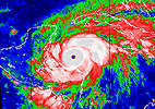 Motion has been almost negligible over the past few hours...perhaps a southeastward drift. In
fact the track prediction models were initialized with a very slow southeastward motion. In
spite of this...almost all of the models predict a West-Northwest to northwestward motion
developing almost immediately. The nogaps... barotropic and the medium/deep-layer bam
show a north-northwestward to northward turn late in the forecast period. With this
guidance...the current official forecast is very similar to the previous one.
Motion has been almost negligible over the past few hours...perhaps a southeastward drift. In
fact the track prediction models were initialized with a very slow southeastward motion. In
spite of this...almost all of the models predict a West-Northwest to northwestward motion
developing almost immediately. The nogaps... barotropic and the medium/deep-layer bam
show a north-northwestward to northward turn late in the forecast period. With this
guidance...the current official forecast is very similar to the previous one.
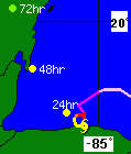
initial  30/0300z 15.5n  85.5w  45 kts inland
12hr vt  30/1200z 15.8n  85.8w  35 kts inland
24hr vt  31/0000z 16.4n  86.4w  40 kts
36hr vt  31/1200z 17.0n  87.0w  45 kts
48hr vt  01/0000z 18.0n  87.5w  50 kts
72hr vt  02/0000z 20.0n  88.5w  35 kts inland
Click here for images of tracking path and weather map |
This is in 10pm forecast, they keep saying this, but it hasn't happened yet. If it doesn't soon, it will burn itself out in the next 24 hours over Honduras. But all models predict in next 12-18 hours an immediate swing to NW. Let's hope they continue to be wrong.
They say for Gunaja, Honduras, there's a 99% chance the hurricane will be within 65 miles at some point in the next 24 hours. And that there is only a one percent chance it will be there in the following 24 hours. Radical projection for a hurricane that basically hasn't moved in 2 days.
tropical storm warnings are in effect for the caribbean coast of Honduras...guatemala...belize...and the Yucatan Peninsula of Mexico from Cabo catoche southward...including the offshore islands. A hurricane watch is also in effect for the coast of belize. Small Craft in these areas should remain in port.
At 10 pm EST...0300z...the center of Tropical Storm Mitch was located near latitude 15.5 north...longitude 85.5 west or about 25 miles...40 km...south of Limon Honduras.
Maximum sustained winds have decreased to near 50 mph... 85 km/hr... with higher gusts. Weakening is likely while the center of Mitch remains over land...but the storm could re-intensify if the center emerges from the coast.
Tropical storm force winds extend outward up to 175 miles...280 km from the center...mainly over water.
Estimated minimum central pressure is 995 mb...29.38 inches.
Additional rainfall totals of 15 to 25 inches...with locally higher amounts...are possible over the mountains of Honduras and other parts of central America. These rains could cause life-threatening flash floods and mud slides.
Coastal flooding due to strong onshore winds and waves continues over portions of the tropical storm warning area.
Repeating the 10 pm EST position...15.5 n... 85.5 w. Movement...nearly stationary. Maximum sustained winds... 50 mph. Minimum central pressure... 995 mb.
An intermediate advisory will be issued by the National Hurricane Center at 1 am EST followed by the next complete advisory at 4 am EST...Friday.
tropical storm warnings are in effect for the caribbean coast of Honduras...guatemala...belize...and the Yucatan Peninsula of Mexico from Cabo catoche southward...including the offshore islands. A hurricane watch is also in effect for the coast of belize. Small Craft in these areas should remain in port.
Tropical storm center located inland near 15.5n 85.5w at 30/0300z position accurate within 40 nm
present movement nearly stationary
estimated minimum central pressure 995 mb max sustained winds 45 kt with gusts to 55 kt 34 kt.......150ne 150se 20sw 150nw 12 ft seas..350ne 250se 0sw 350nw all quadrant radii in nautical miles
repeat...center located inland near 15.5n 85.5w at 30/0300z at 30/0000z center was located near 15.5n 85.5w
forecast valid 30/1200z 15.8n 85.8w...inland max wind 35 kt...gusts 45 kt 34 kt...150ne 150se 0sw 150nw
forecast valid 31/0000z 16.4n 86.4w max wind 40 kt...gusts 50 kt 34 kt...150ne 150se 50sw 150nw
forecast valid 31/1200z 17.0n 87.0w max wind 45 kt...gusts 55 kt 34 kt...150ne 150se 75sw 150nw
request for 3 hourly ship reports within 300 miles of 15.5n 85.5w
extended outlook...use for guidance only...errors may be large
outlook valid 01/0000z 18.0n 87.5w max wind 50 kt...gusts 60 kt 50 kt... 30ne 30se 30sw 30nw
outlook valid 02/0000z 20.0n 88.5w...inland max wind 35 kt...gusts 45 kt
Cabanas held up well.
Restaurant has heavy damage.
Poolside Bar has heavy Damage.
Beach fron sand washed up to 12 foot high pile of sand in front of
Cabanas.
I am going on my honeymoon next friday November 6th to Five Sisters then
Captain Morgans and finally Blackbird Caye, is there any hope? Will
anything be open? We don't mind a dealing with damage. If the airport
is open and the hotels are open, we plan on going.
As far as I know, everyone that is still here is fine.
Everything I've seen here people-wise has been positive apart from the looters, and one hardware store owner who "gouged" people on plywood, chartered a boat with 40 person capacity for his family of 6-12 (the number varies depending who you talk to), and refused to let anyone else on and is now considered dirt by many folk here for his actions.
A special suggestion to the dogs (4 legged canine type) who somehow manage to look as cheerful as ever. Lots of dogs running around, and all are friendly as far as I can see.
A word to the folks of the Bay Islands, Honduras...I know that there are a lot of people here with sadness and pain in their hearts for you all. Our prayers are with you.
Here on Ambergris Caye we still have 72 hours at least of waiting, but everyone seems fine.
The fact that most of the country hasn't lost telephone contact is also high praise for BTL. The one complaint, the loss of e-mail service for 36 hours is not yet explained, but was most noticable to rural communications in the districts. Here the complaints and loss of contact was made up by telephone.
On the down side, many rural areas have complained of lack of radio and television information on the local scene. These problems are probably technical in nature, coupled with low power transmitters. It may pay the government to form a joint venture corporation with repeater stations for the private sector, radio and television stations and find a reasonable fee schedule so that all transmitters, could utilize the repeater net and give citizens throughout the nation of many choices in Belizean based private broadcasting.
Channel 5, daily news was disappointing. It being primarily a local town station, this is understandable. The news being one day old before mounting is also a drawback for emergencies. That they cannot be seen, or heard in all parts of the country and the most remote rural communities is also a major deficit. That they only seem to have capability of issuing news for their local town scene, makes their station complaints redundant anyway. What ever other stations there were, probably also do not have nationwide rural propogation capability. So the idea of some sort of joint venture transmission repeater network seems a good one. It may be necessary in the interests of public service, to make membership in a joint venture nationwide repeater network compulsory, with a fee membership in a ratio to the size of local wattage transmitted.
Evacuations could have started one day earlier from the Cayes it would appear. Since this is a free country, there is no way to make this happen without becoming totalitarian. A trade off in responsibilities.
The use of the e-mail and computer technology, which is heavily reliant on telephone connection has gone well. Most of the effort has been from Belizeans on the ground, in the evacuated areas, and friends of Belize, who have been spending their money in long distance international phone calls to find out information from relatives and friends around the country and reported it to the list serve and to the web page for the Hurricane Emergency. This is a fine model to develop on in the future. This part of the operation has been and continues to be highly successful to those who are using it. There is considerable complaining about lack of up-to-date news on the position of the hurricane and other data. Presumably next time, there will be a repeater network enabling rural citizens and even those many refugees in the Belmopan and Cayo District who are complaining of lack of information, to tune portable small televisions, or radios to a variety of the smaller stations, serving any local town in the country and catch up by tuning across the dial, or frequencies, or channels, to get local news from any particular part of the nation with which they may have an interest. In variety, you may get a better overall picture of what is going on, rather than some dignitary at a central location giving a biased one sided viewpoint. The latter system leads to inaccuracies and propoganda. These are things to improve and look forward to, growth pains, so to speak.
All in all, things are going well and Hurricane Mitch is doing a part, by turning away from Belize. It is frightening to imagine "what could have been" with the terrible monster of Monday and Tuesday past.
The lessons here learned by the newer younger generation are valuable
ones. For one, I know Wendy is going to go without food next time around
and make sure the house is insured.
Ray Auxillou
PS I HAVE MY BUSINESS LINE OPEN SO PLEASE LEAVE A MESSAGE.
1-800-997-7378 OR 1-281-528-7378 E-MAIL [email protected]
Sincerely, Charles Leslie
Chris H. Bumann
Wind speeds though, are basically trade wind normal. Nothing to get excited about. The center of the low pressure area is inland, roughly 30 miles East of Puerto Trujillo area in Honduras. They are getting some localized rain and squalls.
At the moment, the only danger from Hurricane Mitch, other than rainfall, is the fact that it still retains it's strong circulation pattern. It is now over a 1000 miles across in diameter.
There is no threat from Storm Mitch at this time. Nor likely to be, to the coast of Belize before Saturday in the worst case scenario. The low pressure center would have to get back over the sea to build up intensity. This in itself would take a day or more, in time. That at some future date, late Saturday, or possibly Sunday, or even next week; that Storm Mitch would again become a dangerous Hurricane is a distinct possibility, with a rating of 47%.
At the moment, life should go on as usual and expect to possibly
become realerted once again, from midday Saturday onward.
Ray Auxillou
looks like we are gonna get socked in for 3 or 4 days with gusty winds and mucho rain...computer forecasts are for storm to move our way but not develop..but those are computer anaysis! so far they have been wrong and the 'track' and speeds change every 24 hrs..not blamin them..soemthings you just cant predict..my experience tells me that when a storm hits mountainous land and the center moves in..then it do sent bounce back and turn into a hurricane..hope my intuition is right! we have had cat 5 waves hit us and noone has got hurt and no serious damage..so if mitch wants to bouce back at us then have at it and then it can get the hell out of here so we can get back on track!
Thursday, October 30, 1998
My fellow Belizeans:
The latest reports from the weather bureau state that Hurricane Mitch remained nearly stationary during the last several hours. The center of the hurricane was located near the city of Limon in Honduras. The eye of the storm will be over or near the central coast of Honduras for another 24 hours, although little overall motion is expected through today. Mitch is still a serious threat to Belize and the entire country remains under RED II warning.
Hurricane Mitch is currently located 200 miles South-East of Belize City, and 210 miles East of Punta Gorda. Mitch is likely to develop a northwesterly motion today, which will place its eye somewhere in the vicinity of Ambergris Caye late tomorrow, Friday. Maximum sustained winds have decreased to 75 miles per hour. This means that Mitch is now a Category 1 Hurricane, but winds are likely to increase significantly as the hurricane approaches Belize.
The National Emergency Management Organization has been meeting regularly over the past few days, assessing the situation and making adjustments to improve our preparedness.
Yesterday, I visited most of the Hurricane shelters in Belize City. Our people were in good spirits, in spite of the hardships they are experiencing. To improve the conditions in shelters, the National Emergency Management Organization has decided to allow persons in the hurricane shelters in Belize City and Belmopan to leave the shelters TEMPORARILY to allow us to clean and sanitize them.
Once these hurricane shelters have been cleaned, people should return to their shelters by 5:00p.m. this evening. I repeat: Return to shelters by 5:00p.m. this evening.
B.D.F. and Police patrols will be intensified in the streets of Belize City while the hurricane shelters are being cleaned.
Hurricane Mitch will remain a threat to Belize for the next two days because it is moving so slowly.
I have been advised that flooding is likely to begin throughout the country, and major highways are likely to become impassable. Those persons who return to Belize City and other coastal areas today are warned that they will probably be unable to return to higher ground as Hurricane Mitch approaches.
Ambergris Caye and other islands are in particular danger, and we continue to evacuate residents. No one is to return to any caye until the all clear signal is given.
Residents throughout Belize must remain on full alert, and continue to monitor closely the progress of Hurricane Mitch. Listen to the official weather reports and announcements from the National Emergency Management Organization.
At the moment, the supply of fuel is limited. As a result, fuel will be rationed, and people will be allowed to purchase a maximum of five gallons per vehicle. Please refrain from unnecessary driving. Where possible, use car pools or bicycles, and for shorter distances, walk.
We appeal to shop owners to reopen their shops today so that people can replenish their supplies.
The danger has not passed. We ask you to remain patient, calm and cooperative until you receive further information from the National Emergency Management Organization.
A few moments ago, I spoke with Prime Minister Musa and gave him an update on the current situation. Mr. Musa has been keeping the international community fully briefed and he has already secured commitments of assistance, if the need arises.
As a nation, we feel for our brothers and sisters in nearby Honduras and extend our sympathy to them. As soon as conditions permit, we will offer our assistance.
We continue to pray for God's blessing for the safety of Belize and for all people in Belize. God bless Belize, and God bless us all.
Thank You.
The two largest shelters with 500 + were at the convention center in San Ignacio, and the Civic center in Belmopan. I was just supporting the army of volunteers.
Flooding is now a real problem in the west, and as of 4pm large areas of farmland are under water.
Many people appear to have already returned to Belize City.
Frank Redmond
1. There has been no significant changes to report.
2. We've been bugging friends and family on the island since Monday and we decided to give them a rest and let them go about further preparations and repairs.
3. The volunteers are tired and have personal requirements (like showering, sleeping, and with luck even eating a hot meal) that we would like to do now that there is a lull in the storm.
Rest assured that as changes occur we will post them and of course we will continue to try locating individuals.
The curvature and circulation of the storm is very wide spread. If the tropical storm continues to strengthen during the night, the feeder bands would tighten up and become more compact. This is not expected to happen, while the storm center is over land. However, the center is much closer to the coast again and part of the most intense winds are again over open water.
Mitch still has potential to reform and has reformed it's circulation, if not the overall speed of a hurricane.
There is unlikely to be any threat to Belize before tomorrow daylight.
So people can get a good night's sleep in Belize, whereever you are.
But keep touch in the morning and check again.
Ray Auxillou
Also a report that homes and business south of San Pedro are at free disposal to looters since the police force is centralized in the downtown area only. Chris & Becky tell me that Victoria House for example, was completely evacuated as is the case with several other places.
Upon arriving we were informed that doctors could not determine the blood type of the child and that we should return home until further notification since the blood screening equipment was not functioning.
The hospital is crowded and people with loved ones there has looks of despair in their faces...
...Mitch still stationary along the coast of Honduras...
A hurricane warning remains in effect for the caribbean coast of Honduras...guatemala...belize...and the Yucatan Peninsula of Mexico from Cabo catoche southward...including the offshore islands of these areas.
At 1 pm EST...1800z...the center of Hurricane Mitch was estimated by the hurricane Hunters to be located just inland...near latitude 15.9 north...longitude 85.6 west...or near the city of Limon Honduras.
Mitch remains nearly stationary. A slow movement toward the West- Northwest or northwest is expected to begin later today or tonight. On this track...the core of Mitch will be over or near the central coast and adjacent islands of Honduras for another 24 hours. Mitch is likely to remain a threat to the northwestern caribbean for another two days.
Maximum sustained winds are near 75 mph...120 km/hr...with higher gusts. Mitch could weaken to tropical storm strength later today... but restrengthening is possible if the center moves away from land.
Hurricane force winds extend outward up to 30 miles... 45 km... from the center...and tropical storm force winds extend outward up to 175 miles...280 km.
Estimated minimum central pressure is 990 mb...29.23 inches.
Additional rainfall totals of 15 to 25 inches...with locally higher amounts...are possible over the mountains of Honduras and other parts of central America. These rains could cause life-threatening flash floods and mud slides.
Storm tides of 2 to 5 feet above normal astronomical levels are possible near the center of the hurricane...accompanied by large and dangerous battering waves. Dangerous coastal flooding due to strong onshore winds and waves is also occurring over other coastal locations in the hurricane warning area.
Repeating the 1 pm EST position...15.9 n... 85.6 w. Movement... nearly stationary. Maximum sustained winds... 75 mph. Minimum central pressure... 990 mb.
This Tropical Wave Mitch, still has a defined circulation. The chance of it turning north, coming off the land and over the open sea to once again become Hurricane Force, is rated at 35%.
Most Belizeans are financially prohibited from having internet access, but for those with access to High School computer labs, with FREE Educational Internet Access, can log on and see the storm very well from satellites that are 20,000 miles away in the sky. Go to http://www.nhc.noaa.gov/. There are numerous satellites and all the earth is available for viewing, by photograph, infra red, radar and many other forms. Take your pick!
This webpage also has a box for satellite photo's and shows the cloud cover and circulation of the storm. You just click on the photo box and it will link you to the cloud cover photo's of Mitch. The other GEO-8 satellite gives pictures every half hour, in infra red for storm cells.
With the internet, and I am seriously sorry that most Belizeans are prevented from getting the usage out of the internet by communications policy. Any person can be their own Hurricane meteorologist today. You have access to the Hunter airplane reports, the weather stations. Numerous independent weather channels and reporting, and a truly large host of different type satellite coverage. Instant meteorology!
No longer does any citizen, anywhere in the world, have to be censored and kept in the dark, with sporadic announcements from weather bureaucrats in remote centralized ivory towers, on storm strengths and locations. If you have electricity and a telphone, own a computer and your government has applied itself to enabling you to enter the global village communications age, via the internet, you can see for yourself and judge for yourself.
Welcome to the new world. Get an internet access and see the storm
for yourself.
Ray Auxillou
Maya Island left an airplane at International, they would be the best alternative to doing some evacs. Problem is, no pilot.
No problems at all in Placencia still or in PG, just rain and some wind.
As of mid-day Thursday, Mitch had dropped to tropical storm force and remained stalled over the North Coast of Honduras. The National Hurricane Center in Miami put the center near the Honduras city of Limon at or near 16N 85.6W at 10 a.m., with little movement. Maximum sustained winds as of 10 a.m. had dropped to 65 knots or less, with gusts up to 80 knots.
The storm is responsible for at least 30 deaths so far. According to some reports, at least 14 have died on the island of Guanaja, one of the Honduras Bay Islands. An American citizen was thought lost overboard and drowned off the coast of Mexico while attempting to ferry a catamaran from the United States to Placencia, Belize. No deaths have been reported in Belize.
The death toll in Honduras, where up to 25 inches of rain fell, is likely to rise as more reports come in from areas isolated by swollen rivers, downed telephone lines and closed roads.
Significant property damage is reported on the Honduras Bay Islands and in mainland Honduras. In Belize, the damage has been mostly limited to the loss of docks, a few seafront buildings and beach erosion along the coast and on the cayes. However, full reports from remote cayes are not yet available.
Residents and visitors on the Caribbean Coast of Guatemala, Belize and Mexico still are waiting to see what Hurricane Mitch will do, according to live reports via the Internet and telephone and from weather and news services. Some computer models forecast that the seriously weakened storm might move back out to sea, picking up some power over water and make landfall again around Chetumal, Mexico, before moving through the Yucat½n peninsula. Other observers felt it more likely the storm would dissipate itself in Honduras.
During the worst of Mitch, the Internet proved itself again as a powerful force for rapid communication about the vent. Country-specific newsgroups on the Web and Internet mailing lists such as Belize Culture and Hondo One were very active with real-time information about the storm and its impact. Marty Casado quickly established a Hurricane Mitch site on his popular Ambergriscaye.com Web site. This proved to be one of the best sources of up- to-date information on the storm, with scores of messages from Belize and Honduras posted. Because the Ambergriscaye.com site is based in the U.S., it was able to stay up throughout the storm.
In Belize, the decision now is whether to permit evacuated residents in the west to return to their homes in Belize City and elsewhere, or to wait until it is clear the storm doesn‰t regroup and move westward to Belize or the Yucat½n. Tens of thousands of people are in makeshift shelters. ‹Waiting for Mitch is a bitch,Š said Peter Singfield of Xaibe village in Corozal District in Northern Belize, in an e-mail message.
Some limited looting has been reported in Belize City and in San Pedro. The government has restricted the sale of alcohol.
As of mid-day Thursday, most of mainland Belize was reporting sunny weather.
In Mexico‰s Yucat½n, about 20,000 tourists decided to leave resorts in Cancun,
Playa del Carmen and Cozumel and fly home, while another 10,000 stuck it out.
Lan Sluder, Belize First Magazine
Are we starting to see a silver lining? I've been looking hard for one... Marty
...MITCH WEAKENING ALONG THE COAST OF HONDURAS...
A HURRICANE WARNING REMAINS IN EFFECT FOR THE CARIBBEAN COAST OF HONDURAS...GUATEMALA...BELIZE...AND THE YUCATAN PENINSULA OF MEXICO FROM CABO CATOCHE SOUTHWARD...INCLUDING THE OFFSHORE ISLANDS OF THESE AREAS.
AT 10 AM EST...1500Z...THE CENTER OF HURRICANE MITCH WAS LOCATED NEAR LATITUDE 16.0 NORTH...LONGITUDE 85.6 WEST OR NEAR THE CITY OF LIMON HONDURAS.
MITCH REMAINS NEARLY STATIONARY. A SLOW MOVEMENT TOWARD THE WEST- NORTHWEST OR NORTHWEST IS XPECTED TO BEGIN LATER TODAY OR TONIGHT. ON THIS TRACK...THE CORE OF THE HURRICANE WILL BE OVER OR NEAR THE CENTRAL COAST AND ADJACENT ISLANDS OF HONDURAS FOR ANOTHER 24 HOURS. MITCH IS LIKELY TO REMAIN A THREAT TO THE NORTHWESTERN CARIBBEAN FOR ANOTHER TWO DAYS.
MAXIMUM SUSTAINED WINDS ARE NEAR 75 MPH...120 KM/HR...WITH HIGHER GUSTS. MITCH COULD WEAKEN TO TROPICAL STORM STRENGTH LATER TODAY... BUT RESTRENGTHENING IS POSSIBLE IF THE CENTER MOVES AWAY FROM LAND.
HURRICANE FORCE WINDS EXTEND OUTWARD UP TO 30 MILES... 45 KM... FROM THE CENTER...AND TROPICAL STORM FORCE WINDS EXTEND OUTWARD UP TO 175 MILES...280 KM.
ESTIMATED MINIMUM CENTRAL PRESSURE IS 987 MB...29.15 INCHES.
ADDITIONAL RAINFALL TOTALS OF 15 TO 25 INCHES...WITH LOCALLY HIGHER AMOUNTS...ARE POSSIBLE OVER THE MOUNTAINS OF HONDURAS AND OTHER PARTS OF CENTRAL AMERICA. THESE RAINS COULD CAUSE LIFE-THREATENING FLASH FLOODS AND MUD SLIDES.
STORM TIDES OF 2 TO 5 FEET ABOVE NORMAL ASTRONOMICAL LEVELS ARE POSSIBLE NEAR THE CENTER OF THE HURRICANE...ACCOMPANIED BY LARGE AND DANGEROUS BATTERING WAVES. DANGEROUS COASTAL FLOODING DUE TO STRONG ONSHORE WINDS AND WAVES IS ALSO OCCURRING OVER OTHER COASTAL LOCATIONS IN THE HURRICANE WARNING AREA.
REPEATING THE 10 AM EST POSITION...16.0 N... 85.6 W. MOVEMENT... NEARLY STATIONARY. MAXIMUM SUSTAINED WINDS... 75 MPH. MINIMUM CENTRAL PRESSURE... 987 MB.
AN INTERMEDIATE ADVISORY WILL BE ISSUED BY THE NATIONAL HURRICANE CENTER AT 1 PM EST FOLLOWED BY THE NEXT COMPLETE ADVISORY AT 4 PM EST.
I want to thank the Essene Way and Wayne for providing safe haven and food and
water to the few who couldn't get out of the area. May God Bless them.
Carla Fine aka [email protected]
For all practical purposes, Belize City, the main city in this Central American country, was closed Wednesday. Most of its 75,000 residents seemed to have decided flee the Caribbean port to go somewhere else to wait for Hurricane Mitch.
They had good reasons to be cautious. Belize City was devastated by Hurricane Hattie in 1961 and again by Hurricane Greta in 1978. It's a flat, low-lying city, where many houses are built on stilts and a moderate rainfall is enough to cause flooding.
Those who could headed to the capital, Belmopan, and other places on higher ground. Many others headed to emergency shelters.
Local radio broadcast updates about hurricane conditions and messages from residents searching for relatives from whom they were separated in the haste to leave the city. Cable television was still in service, but only one station was offered: The Weather Channel.
Kevin Everett was among 800 people who spent the night in a packed schoolhouse. If the hurricane hits, his house could be wiped out.
``I'm not worried about that. I'm worried about my life,'' he said.
Beulah Sikaffy invited some friends and employees of her family's business to stay in the three-story building that is her home and office.
By Wednesday, the number visiting was up to an estimated 80 people.
Next door, the 14-room hotel owned by her brother-in-law, Freddy Sikaffy, was closed down.
Soldiers armed with M-16 automatic rifles joined police on patrols to stop looters. ``We've received a lot of burglary complaints. That's why we're here,'' said Police Constable Nelson Augustine.
Soldiers and police also guarded the Fiesta Inn, one of the largest hotels in Belize City. The hotel was closed but a handful of guests with nowhere else to go were permitted to stay.
Bob and Sue Sharpe of Austin, Texas, were among them. Security guards allowed the couple to stay there Tuesday after they fled in a boat from Caye Caulker, a small island where they had been vacationing.
``The water was just coming over the sides of the boat on us all the time,'' Mrs. Sharpe said.
At the hotel, she and her husband share a room with two other men. The restaurant is closed, and there's little to do but wait for breaks in the rain.
Still, she had no complaints.
``It's been wonderful,'' she said. ``We're completely safe and comfortable. We have TV _ even if all you can watch is The Weather Channel.''
Note from Marty: I AGREE! DON'T GO HOME YET! The 48 hour path runs right over the island, and if the storm intensity picks up again as the hurricane slides north, we have trouble all over again. 48 hours is a long time to wait, but it is certainly worth your family. Some folks on the island are still trying to get off.
Conditions at M.R. Just got off the phone with J.L. at The Monkey House... She reports winds are almost calm with intermittent drizzle. the tide level is unusually way down...even for a normal day.. ( can someone explain that? )..Skies were bright but ovecast this morning sunrise.......Monkey River Towns residents are being asked to get out... M. R. in on the river and has low areas .. the town has been partially flooded ... from the high river and the river to their west. this river is also in the town..
They expect this storm to move north in time and suggest track it close to the east coast as it moves on up..... so we still must be prepared..
Honduras took it on the chin for us so far and if we make it out unscathed , can we help them some?
There are no casualties, still plenty of food. Some of the stores opened briefly yesterday to sell groceries to people and plan to again do that today. There have been 12 people arrested thusfar for looting. The storm surge continues, but the waves are much smaller at present. The town board will develop plans to restore the beaches after repair of infrastructure damage is completed.
The people are in good spirits, but still staying prepared in case this storm does the unexpected again. One of our friends said "Our prayers have been answered and God has saved our island" I think that says it all! I have been given some shopping lists by numerous people on the island for goods when I can travel in country. The Lions Club will inform me as soon as I can travel to the island with required goods.
The question confronting Officials and the Cabinet in Belize is what to do with the 60,000 refugees in the Western Districts? Mitch could reenter open water and reform into a probably Category 1 or 2 Hurricane. It could also continue to break up as it moves inland over Honduras like did Hurricane Fifi.
A category 1 or Category 2 Hurricane, is damaging. Mostly property damage. Roofs, trees, power lines down. It is not usually life threatening. Also the storm surge in front of such a Hurricane is usually narrower and about 15 miles in width, with a outer layer of 30 miles.
The likelihood of Mitch becoming a Category 2 Hurricane and striking Belize is at this present time, about 45%. If it did so and struck Belize it would present a flood and tidal surge effect of about 8 to 12 feet for 15 miles in front of it. This means any particular point in Belize would have a 10% chance of getting serious damage. But only on the coast and many offshore islands along the Barrier Reef. The mainland communities would mostly have wind and property damage.
Weighing the problems of having 60,000 people running out of food, and possibilities of cholera, plus sanitation disposal problems against sending people home is a delicate balance. But if they do not send them home, it will probably mean another 5 days for 60,000 refugees in the Western Districts. This decision is a difficult one for the Cabinet. Is it better to send them home, and re-evacuate the offshore Cayes and coastal communities sometime next week, or this Sunday onwards? Or should they recommend people sit where they are? A Category 1 and 2 Hurricane is damaging but not one I would vacate Caye Caulker for, if the chances of a direct hit were only 10%.
Walked to town today....no piers left....debris all over beach so it's not passable...in fact, no beach at all! Most of the dive shops are history.....one of them floated in and is currently wedged in the street between Conch Shell Inn and Cholo's liquor store.
Why or why are we having all these "San Pedro experiences".. I'm ready to be rich and healthy....... not sick and poor!!!!!
Thanks for all you e-mails...I'll write more later...if the elec. stays on and the server decides to send the mail (I had 125 messages tonight). The elec. co. said they will keep elec. on until they run out of diesel and the water company is rationing water for 2 hours each night....thank heavens we have a switch valve on our cistern....at least we have water as long as there is power.
I am informing you that we are on Hurricane Warning, with our two red flags with a black dot in the middle (phase three). The government has played a major role in the evacuation of all cayes, islands, and coastal city and towns. Belize City, Ambergris Caye, Caye Cauker, and other islands have been evacuated to near totallity. People on the districts have taken the hurricane warnings seriously so as to prevent human loss and material damage. Homes have been sealed, reenforced, and stock piled with the necessary food to weather the coming hurricane.
Hurricane shelters have been opened. Many people who feel that their homes are not secure enough have moved into the shelters for the night. During the day they go home to prepare food, and do other necessities. People from the coastal towns and city have travelled inland for security reasons. Here at my village of Succotz people have rented homes to fleeing persons from Corozal, Orange Walk, Stann Creek, Toledo, and Belize District. The local Xunantunich Hotel is filled to its maximum as well as the other hotels in San Ignacio and Benque Viejo.
Many rivers are getting flooded. The Mopan River in the Cayo District is flooded. A ferry that crosses it has been secured to a certain extent. The Macal River is flooding and a wooden bridge that joins two towns has been covered with water. Many other rivers around the country are flooding their banks. Government authorities have called on all people along the river banks to seek higher grounds. The Mojellon Hydorelectric Power Plant might have to let go its waters because it has become too much for it to hold.
It has been raining for the past three days. Schools have been closed since Monday.
Hurricane Mitch is no longer a Hurricane! Hurrah!
During last night, the Hurricane moved inland with more than half the intense area now over the mountains of Honduras. Wind speeds this morning were 75 mph. which is about the speed of wind in an ordinary Front Squall line crossing the country of Belize in December and January coming in front of a Northwester. Dangerous sea conditions for boats. But not really lethal anymore.
Do not get complacent though. Mitch requires watching, though it is no longer a serious threat at this mornings review. Mitch still retains the circular patterns of a Hurricane and if it went north over the open sea could intensify again. At the moment, the Eastward movement of a few miles and the travel southward into the mainland coast of Honduras has forced the wind speeds down below Hurricane Strenght.
Patty Arceo, by merely hearing you on local radio pleading and assisting our brothers and sisters to the extent of sacrificing your own life so as to ensure minimal loss of life says all the good things about you as a leader, human being, Belizean, and love you have for the people of this country. You have inspired strenght, and confidence to all of us Belizeans and non-Belizeans alike. Thanks Patty. Lets us all follow your example to preserve our lives and continue building this great nation of ours. I am connected to the internet at this time of the morning, monitoring the hurricane on the internet. All my house has been properly sealed with plywood. I know that we have brothers and sisters on our cayes, and coastal areas, take care. I have expressed my sincere feelings in these difficult times we are experiencing. Let us all be like a great Belizean Family, obedient and caring. Listen to your radios, seek shelter. preserve life, and afterwards we will build our country again. Lord, hear our Prayers, For God, People, and Country, G.Rosado JP BS
If you see or hear from Patty Arceo (This goes for anyone that sees her.) Please tell her that my prayers are with her and her family. I know that she has been doing a good job as Belize's first elected female representative from a rural area. Tell her that I will see her for Christmas and that I have not forgotten her.
Yours truly
betito
[email protected]
| LINKS TO HURRICANE MITCH INFORMATION: | http://hurricane.terrapin.com/ATL-13A/index.html http://www.wunderground.com/tropical/ http://www.nhc.noaa.gov/index_special.html |