 | BELIZE NATIONAL PARKS, NATURAL RESERVES, & WILDLIFE SANCTUARIES |
BURDON CANAL NATURE RESERVE
WHAT TO SEE
Take a boat trip through the back swamps of the Belize
River Delta. Its the best place to explore mangroves, right on the doorstep
of the city. The red mangroves form. a tunnel right over the Haulover Creek,
home to kingfishers, herons, White Ibis, egrets, and the Common Black
Hawk. All are easy to see.
The banks are lined with gaping mud holes of the Blue Land Crab, a meaty
delicacy much bigger than the Fiddler Crabs nervously scavenging the mud
for food.
Turkey vultures, Pelicans and Magnificent Frigate Birds are overhead as you
carry on down the arrow-straight Burdon Canal, built in the 1920s to help
farmers further south get their crops to market without risking life and limb
on the open sea. The common butterfly along the waterway is the Mangrove
Skipper. Its brown wings have a large orange dot.
The other creature to watch for is the American Crocodile. Extensively
hunted for its skins up to 1981, its now so common the Forest Department
is continually called out to collect them from drains, gardens and school back
yards. Don't expect any 15 foot monsters though. Ecologists are finding the
area along the canal is not ideal crocodile habitat, and most are quite small.
The waterway continues south to the Sibun River, cutting through savanna
before suddenly emerging into the Northern Lagoon. Rising from its shallow
muddy water, two islands are used by nesting Ibis, Herons, Egrets, Pigeons
and others. Both are reserves. At the southern end, is the lagoon's only
outflow, a winding creek that leads into Manatee Lagoon. This is one of the
prime spots for seeing manatee in the whole country!
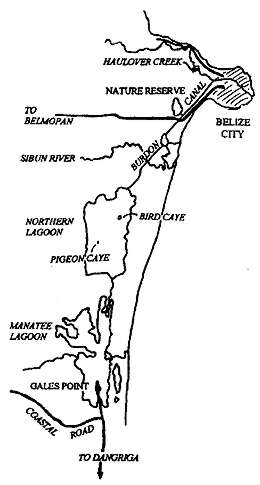
GETTING THERE
This trip, in whole or
in part, can be made from either Gales
Point Village or Belize City. The village
has its own excellent guides who can also
show you other natural attractions in the
area (if you're prepared to hike) like the
magnificent caves towards the Forest
Reserve and nearby turtle nesting beaches.
Gales Point has a guest house (basic) and
a resort, and is connected by bus to
Dangriga and Belize City. The villagers
make regular trips to the Belize market,
and if you're prepared to rough it in a dory
(dug out canoe) and are in no hurry, you
might be able arrange a ride. Just ask
around the village, or phone ahead to the
community telephone (05-22087).
WHEN TO GO
Basically any time, although nesting at Northern
Lagoon's bird cayes takes place from
February to April.
VISITOR FACILITIES
As yet, there
are no facilities on site, so it is best to go
either with a tour from Belize City or with
a guide from Gales Point. The Canal and Haulover Creek are used for recreation and tourist boat trips to
Norther and Southern Lagoons.
CURRENT AREA
The site was designated in June 1992 (SI 88), following
recommendations from the CZMU. In 1953, Crown Lands within I mile of the centre of Fabers Lagoon
was designated a game reserve under the Crown lands Ordinance, and was known as the Fabers lagoon
Bird Sanctuary. This designation theoretically still stands. Current calculation of the area of
this reserve is 5970 acres. When calculated more accurately on GIS, the size is 5255 acres.
JUSTIFICATION
Designated to protect mangrove adjacent to Belize City, in response to rapid
mangrove clearance around the city.
HABITATS
Mangrove.
HOLDRIDGE LIFE ZONE
Tropical Moist.
ZOOGEOGRAPHICAL AFFINITIES
Coastal and Mangrove.
WILDLIFE
The site's bird life, Morelet's crocodiles, lepidoptera and odonata have been examined, along
with adjacent waterways further down the Canal and along the Haulover Creek. Overall, about 50 birds
were recorded. Meerman also includes incidental notes on plants and mammals encountered. Results
from studies suggest that sites adjacent to the current reserve, namely the Haulover Creek and Burdon
Canal between Jones and Northern Lagoon, contain higher biodiversity than the reserve itself. The land
cover of the reserve and surrounding area has been mapped and is shown on large scale colour air photos held by the Forest Department, The reserve's vegetation
is almost entirely Red Mangrove, with a belt of mixed freshwater swamp species such as Bullet Tree
around Fabers Lagoon.
LOCAL POPULATION
The site bounds the western edge of Belize City (population 40000), and is
being rapidly encroached upon by its expansion.
PHYSICAL FEATURES & CLIMATE
The area is a low lying basin, comprising the backswamps of the
Belize River/Haulover Creek delta. It is permanently waterlogged, with a gradient of saline to fresh water
arising from regular tidal inundation at the seaward fringe and freshwater flooding from
inland.
During
the dry season, parts of the reserve may become hypersaline. The site's elevation is generally sea level,
but rises to approximately 4ft along river banks. It receives approximately 75-80 inches of rain a year.
The tide in the Canal is semi-diurnal, and the water level at the Canal Bridge lags about 2-3 hours behind
the centre of Belize City.
| BELIZE NATIONAL PARKS, NATURAL RESERVES, & WILDLIFE SANCTUARIES |
Belize Parks Home /
Bacalar Chico /
Bird Sanctuaries /
Burdon Canal Nature Reserve /
Blue Hole National Park /
Great Blue Hole, Lighthouse Reef /
Chiquibul National Park and Caracol /
Cockscomb Wildlife Sanctuary /
Columbia River Forest Reserve /
Community Baboon Sanctuary /
Crooked Tree Wildlife Sanctuary /
Five Blues Lake National Park /
Glover's Reef Marine Reserve / Guanacaste National Park /
Half Moon Caye Natural Monument /
Hol Chan Marine Reserve /
Laughing Bird Caye /
Marco Gonzales /
Mexico Rocks /
Mountain Pine Ridge Forest Reserve /
Payne's Creek National Park /
Rio Bravo Conservation and Management Area /
Shark Ray Alley /
Shipstern Nature Reserve /
Turneffe Atoll /
|