 | BELIZE NATIONAL PARKS, NATURAL RESERVES, & WILDLIFE SANCTUARIES |
LAUGHING BIRD CAYE NATIONAL PARK
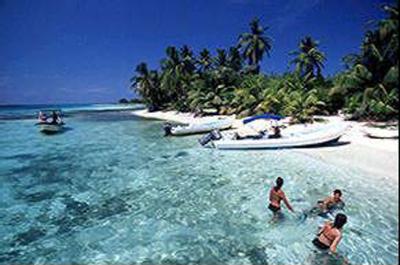 Laughing Bird Caye National Park is
one of the gems in a string of pearls that
is the Belize Barrier Reef World Heritage
Site. It is a beautiful Belizean isle
situated on the western side of the Victoria
Channel, only 11 miles off the coast from
Placencia Village in the Stann Creek
District of Belize.
Laughing Bird Caye National Park is
one of the gems in a string of pearls that
is the Belize Barrier Reef World Heritage
Site. It is a beautiful Belizean isle
situated on the western side of the Victoria
Channel, only 11 miles off the coast from
Placencia Village in the Stann Creek
District of Belize.
The uniqueness of this structure contributes
to both the abundance and variety of coral habitats and marine life. The
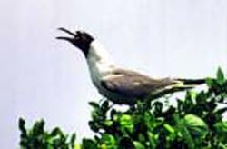
Caye gets its name from the Laughing
Gull (Larus artricilla). This bird once
used to breed on the Caye, but because
of growing human presence, the colonies
have moved to nearby undisturbed
cayes for breeding.
 Due to the uniqueness of the Caye, the
Faro, and the abundant and diverse marine
habitats and life, the Caye was declared
a protected area in 1981 under the
National Parks System Act. On December
21st, 1991, Laughing Bird Caye National
Park was declared. Finally, in 1996
the Belize Barrier Reef Reserve System
was inscribed on the World Heritage List
with Laughing Bird Caye National Park
designated as one of the premiere protected
areas within the World Heritage
Site.
Due to the uniqueness of the Caye, the
Faro, and the abundant and diverse marine
habitats and life, the Caye was declared
a protected area in 1981 under the
National Parks System Act. On December
21st, 1991, Laughing Bird Caye National
Park was declared. Finally, in 1996
the Belize Barrier Reef Reserve System
was inscribed on the World Heritage List
with Laughing Bird Caye National Park
designated as one of the premiere protected
areas within the World Heritage
Site.
Other birds can be seen on the Caye
including the Brown Pelican, Green Heron, Melodious Blackbird and many
other birds from the surrounding cayes
and strays from the mainland. There are
also a variety of lizards and insects on
the Caye.
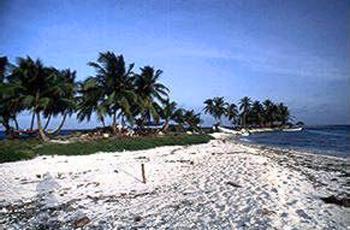
The island is covered with coconut
trees and scattered coastal mangroves.
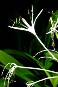
Seven plant species have been recorded
on the island:
*Coconut tree - Cocos nucifera
*Spider Lily - Hymenocallis littorallis
*Seaside Purslane - Sesuvium
portulacastrum Euphorbia sp.
*Red mangrove - Rhizophora mangle
*Morning Glory - Ipomoea sp.
*Black mangrove - Avicennia germinans
 Tourists with local guides from
Placencia Area (members of the
Placencia Tour Guide Association) are
carried in small boats (30 foot or less)
with outboard motors, or slightly larger
boats (40 foot or less) with inboard engines.
These tours are for sightseeing,
snorkeling, SCUBA diving, and picnicking;
generally lasting one to six hours.
Tourists with local guides from
Placencia Area (members of the
Placencia Tour Guide Association) are
carried in small boats (30 foot or less)
with outboard motors, or slightly larger
boats (40 foot or less) with inboard engines.
These tours are for sightseeing,
snorkeling, SCUBA diving, and picnicking;
generally lasting one to six hours.
The basic boat load is based on four
people plus a guide. Occasionally there
can be from twelve to twenty people on
a given boat. Sometimes, these visiting
groups will build fires for cooking. The
Conservation Branch of the Forestry
Department of the Natural Resources has
declared that there can be no overnight
stays on the Caye. There are no rest
rooms facilities or shelter on the Caye.
The primary users of Laughing Bird
Caye are the residents of Placencia Village.
The locals will visit the island for a
day of snorkeling, diving and picnicking.
Presently, there is no rest room facility.
The number of people using the caye in
this capacity is hard to estimate as it is
generally seasonally centering around
holidays and weekends. Placencia is a
popular destination for Belizeans. There
is also sporadic traffic from other surrounding
communities such as Independence,
Seine Bight, and the nearby citrus
and banana plantations.
The heavy use has impacted the terrestrial
habitats and is beginning to impact
the undersea environments.
Local community groups and national
regulatory authorities are working together
to help save and manage the Park.
As always, sustainability is a major problem.
Other problems related to
sustainability include management, research,
and enforcement.
If you would like further information
about the Laughing Bird Caye National
Park or how you might be able to help,
please email [email protected] or
visit www.laughingbird.org to fill in a
form with your ideas, questions, suggestions
or comments.
 ESTABLISHMENT HISTORY
In response to
lobbying by local tour operators and
conservationists, this site was designated in
December 1991 (SI 167). Its extension has been
recommended by Wilson (1995) to help cover
gaps in Belize's protected area network. A draft
SI has been produced (with boundaries expanded
to cover surrounding marine habitats) but has
not yet been gazetted
CURRENT AREA
The area of this reserve is relatively easily to calculate as it only covers I isolated
small caye. The area estimated in the SI is 1.4 acres, taken off a ground survey of the caye (Entry 1287),
which actually gives 1.8 acres. The LIC, mapping the reserve using GIS, calculate a figure of 30 acres,
which is incorrect.
The boundaries of the proposed expanded reserve are defined by coordinates, covering an area of ?
according to the draft SI. The co-ordinates and area estimate in the draft SI have been determined using
GIS and are therefore identical.
JUSTIFICATION
The caye has traditionally been used for recreational purposes, and designation was
initiated to control this, to prevent it being leased out and to benefit eco-tourism operators in Placencia.
Laughing Gulls used to breed there but has moved to nearby cayes because of disturbance. The marine
habitat in the proposed extension is considered representative of the faroe reef formation on the
southern part of the barrier reef.
HABITATS
Cocal, littoral thicket, mangrove. (Proposed extension includes seagrass beds and reef).
ZOOGEOGRAPHICAL AFFINITIES
Caribbean and Marine.
MARINE REGION
Southern Red Complex Division in the Stann Creek Region.
WILDLIFE
There is little terrestrial biological information on the site. Previously it was used as a nesting
site by Laughing Gulls, but due to increased human disturbance they abandoned nesting in 1990 and
moved to a nearby caye. The vegetation is dominated by Coconuts, but there are mangroves and
extensive herbaceous coverage as well.
LOCAL POPULATION
Placencia (fishing and tourism) is the nearest settlement,11 miles to the west,
on the mainland.
PHYSICAL FEATURES & CLIMATE
The current site consists of an elongated sand caye.
VISITOR FACILITIES
The reserve is visited regularly, mostly be tourists carried out by tour operators
from Placencia for picnics, snorkeling and diving. The site is also used by Belizean day trippers at
weekends and holidays. One cruise ship includes the caye in its tour, and brings in 45-70 passengers
once a week during its November to April season. Previously the reserve was used (and still is
occasionally) for overnight camping but the FD has prohibited this, primarily due to the lack of toilet or
other waste disposal facilities. Some mooring buoys have been installed to prevent anchor damage to
the surrounding reef. Private yachts and sea kayaks also use the site regularly. There is 1 trail through
the centre of the caye.
Click here for information on the Pelican Cayes, a hotspot of biodiversity and destruction in the Belize Barrier Reef Reserve World Heritage Site
| BELIZE NATIONAL PARKS, NATURAL RESERVES, & WILDLIFE SANCTUARIES |
Belize Parks Home /
Bacalar Chico /
Bird Sanctuaries /
Burdon Canal Nature Reserve /
Blue Hole National Park /
Great Blue Hole, Lighthouse Reef /
Chiquibul National Park and Caracol /
Cockscomb Wildlife Sanctuary /
Columbia River Forest Reserve /
Community Baboon Sanctuary /
Crooked Tree Wildlife Sanctuary /
Five Blues Lake National Park /
Glover's Reef Marine Reserve / Guanacaste National Park /
Half Moon Caye Natural Monument /
Hol Chan Marine Reserve /
Laughing Bird Caye /
Marco Gonzales /
Mexico Rocks /
Mountain Pine Ridge Forest Reserve /
Payne's Creek National Park /
Rio Bravo Conservation and Management Area /
Shark Ray Alley /
Shipstern Nature Reserve /
Turneffe Atoll /
|