 | BELIZE NATIONAL PARKS, NATURAL RESERVES, & WILDLIFE SANCTUARIES |
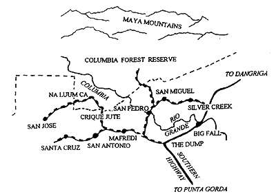
COLUMBIA RIVER FOREST RESERVE
WHAT TO SEE
For intrepid forest lovers, this is the place to head.
Columbia is rugged and remote and spreads over the southern and most
tropical comer of the Maya Mountains. It's been the focus of several recent
expeditions, each of which has revealed new species never before recorded
in Belize, and some new to science. It's the ultimate forest experience in
Belize. The hot wet weather super-charges plant growth, and Toledo has
also been unscathed by hurricanes for longer than anywhere else in the
country. Once you're in the forest, there is so much wildlife, there really is
little point in even beginning to list what can be seen. You haven't seen Belize
until you've seen Toledo.
GETTING THERE
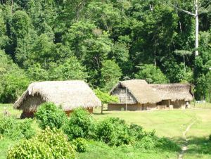
The ring of Mayan farming villages to the south of the
reserve are the jumping-off point for the intrepid to explore the area, offering
a completely different cultural setting for getting into the forest. Until later this
year (1996) the reserve can be reached only by foot though. It is a tough
walk of about four hours from San Jose, or slightly less from San Pedro
Columbia and San Miguel, and less again from Na Luum 'Ca and Crique
Jute. The only existing trails into the reserve are logging tracks, along
which it is relatively easy to walk. Road access is however being improved,
with a more permanent logging track being put in to the reserve as the result
of a recent logging license (according to the Forest Department, the logging
won't affect the most environmentally sensitive parts of the reserve, and it is
the most serious attempt at introducing sustainable hardwood extraction in
Belize for decades). The track will enter the reserve to the north of San
Miguel. Buses run to and from the above-mentioned villages four times a
week from Punta Gorda. You can hitch (offer the driver a small contribution
if you do), from the point where the San Antonio road begins, at the part
where the Southern Highway takes a 90 degree turn towards the coast, at
the Shell station. San Pedro is two miles down the first road on the right,
which begins one and a half miles from the Highway. San Jose is 15 miles
from the junction. Tours by vehicle can be arranged by hotels in Punta Gorda
or by the Fallen Stones Hotel and Butterfly Ranch near San Pedro
Columbia.
WHEN TO GO
The best time is in January, February and March when it is
not too hot. Remember Toledo is the wettest part of Belize.
VISITOR FACILITIES
There is accommodation in the village guest houses
and home stays (basic). It's always good to call ahead (to the community
phone number in the phone book) to arrange your stay a day or two in
advance. San Pedro Columbia has slightly more options, and there is also
luxury accommodation in the area (The Fallen Stones Hotel and Butterfly
Ranch has the best forest view in the whole country).
ESTABLISHMENT HISTORY
The site was designated in June 1954 (SI 33), with an area of 110720 acres.
In May 1977, it was reduced to 102965 acres (SI 40), the excision including mahogany taungya
plantations established over 1955-63). In 1968, part of the area was defined as a Nature Reserve, but this
was abandoned in 1978, and does not appear to have been formally designated. Reflecting the realities
of encroachment, a revised reserve boundary has been written up under the auspices of FPMP, and a
draft SI prepared. It has not however, been gazetted, although its new borders were cut and demarcated
in 1994.
CURRENT AREA
There are 2 main sources of mapping error with this reserve:
Its northern boundary is defined in its SI as the Maya Mountain Divide, but particularly at its
western end, this is not a clearly defined sharp ridge, but a plateau. The boundary definition used
by Bird (1994) is a reinstatement of the correct and earlier version, and does not match that
sometimes used by other sources in the interim. The correct alignment includes the Rio Machiquita
Creek drainage.
The last legally gazetted area is out of date. Along the reserve's southern limit, a new boundary has
been demarcated in 1994, excluding areas of significant permanent encroachment. The new
boundary has not been incorporated into a re-designation. of the Forest Reserve, so its legally
gazetted acreage exceeds its actual newly defined on-the-ground limits.
The area estimated in the current SI is 102965 acres. When calculated on GIS, the area derived is 102940
acres. The area calculated on GIS of the proposed new boundary gives an area of 97894 acres.
JUSTIFICATION
According to the reserve's original SI designation was 'to preserve valuable
mahogany forest from clearing for cultivation and to secure land for Government re-afforestation with
mahogany and other species'. Contemporary justification is its potential for sustained hardwood
production, its high biodiversity, and its importance for watershed protection.
HABITATS
Broadleaf forest, montane forest, pine savanna and secondary broadleaf forest.
HOLDRIDGE LIFE ZONE
Mainly Subtropical Lower Montane Wet, with some Subtropical Lower
Montane Moist to the west and Subtropical Wet to the east.
WILDLIFE
A sequence of ecological studies has recently been undertaken, largely in response to the
threat of agricultural incursion and renewed timber exploitation. In the report of an early study, Matola
summarizes pioneering exploration and exploitation of the area, and makes the first Belizean recording
of the Common Woodnymph. Information of common plant species is given, with species lists for
birds, amphibians, and reptiles, plus incidental notes on mammal observations. Speculation on the
conservation and ecological significance is made in reference to the markedly different vegetation
communities of the Little Quartz Ridge. Significant additions from Meyer et al. (1993a) are reports on
two frog species new to science, of the genus Eleuthrodactylus. Brief notes are also provided on other
amphibians, reptiles, birds mammal , fish and invertebrates encountered during a four day survey of the
Praco Ha Creek area. Further work, resulting from a second 4 day expedition, examined Tzimin Che Ha
Creek (Mountain Cow Creek) and Chaque Ha Creek (Wood-quail Creek) areas. Common tree species
are listed with further notes on the un-described Eleutherodactylus frog, other amphibians, reptiles,
birds, mammals, fish crustaceans and molluscs. Findings from a 2 week study by Parker et al. (1993)
provide seminal additional information, including numerous new Belizean records for plant, bird and
amphibian groups. The collection of over 400 plant specimens produced a large number of new records
for the country, with 15 out of 68
fern
species collected previously un-recorded for example, reflecting
the botanical neglect of the lower montane wet forests of Belize. Botanical data collected from Little
Quartz Ridge also tended to support Matola' s assertion of an un-common vegetation community. In
regard to birds, Parker tentatively concluded the area was 'unusually rich' , with 224 species recorded,
including 232 (over 90%) restricted to evergreen forests in Belize (this did not include a further 8
species recorded by Matola . Other birds included typical wet foothill species and a small contingent of
montane species. Overall, at least 15 of the birds identified have restricted ranges and are described as
threatened by forest clearance elsewhere in their ranges. An additional 35 considered rare or accidental
in Belize by Wood et al., are represented by large populations in the reserve. Of the migrant
community, Parker asserts that the reserve 'may support globally significant numbers of Neotropical
migrants'. The potential importance of the lower montane forests for the Cerulean Warbler is also
noted. No new records of mammals were found, the mammal community being considered typical of
lowland forest, albeit somewhat depleted in commonly hunted species. In addition, 2 new frog species
previously un-recorded for Belize were identified (Hyla minera and H. bromeliacea) (the first has since
been found in Monkey Bay and Bladen Nature Reserve and is therefore probably widespread).
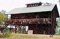 | | Monkey Bay Research Facility |
LOCAL POPULATION
The population of the reserve's fringe is composed almost entirely of Kekchi
and Mopan Maya Indians. Sixteen villages are considered as being within daily communication
distance, approximating to a 5 mile radius of the management area. All are farming communities.
PHYSICAL FEATURES & CLIMATE
The reserve includes a wide variety of landforms. The majority
consists of medium to high limestone karst (southern foothills of the Maya Mountains), and is steep
and rugged in nature. In common with other similar geological environments in Belize, caves are
common and, with numerous sinkholes, surface drainage limited- It also includes Little Quartz Ridge, a
unique physiographic feature in Belize, comprised of a fitted fault block of Paleozoic prophorytic rocks,
distinctly separate from the Maya Mountains, and with a summit running for 9 miles on a southwest-
northeast alignment with an altitude of 870-980 yards.
Terrain within the reserve vanes from 900-2700ft above sea level . Average rainfall over the area is
estimated to be in the region of 100 inches a year, with much higher figures for the parts of the reserve at
higher elevation. The Rio Machiquila is the only Belizean stream draining into the Gulf of Mexico rather
than the Caribbean (this may have implications for aquatic fauna).
ACCESS
The western portion of the reserve has a well-defined trail which links together abandoned
logging camps.
CULTURAL FEATURES
Many of the caves show evidence of Mayan use, and there is strong evidence
that at least one major ceremonial centre lies in the reserve.
Here are some points of interest in the area:
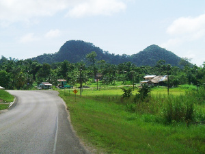
The Southern Highway at Elridgeville |
Toledo district in the south of Belize is an area unparalled in beauty. In 2003 the southern highway remained to be fully paved and Toledo was not yet connected to the national electricity grid. Although those infrastructure improvements have now been made, Toledo still remains an emerging destination with all that implies for exciting authentic experiences with diverse traditional people and cultures.
The older generation in Toledo remember the days when the only way to Belize City was by the coastal ferry which kept the deep south in touch with the outside world. Later the James Bus took eight to twelve hours to bump its way over one hundred and eighty miles of mainly dirt road. When the paving of the Southern Highway was completed in 2009 the last piece was in place. Toledo was finally “part of the rest of Belize” with modern infrastructure and quick and easy access (3.5 hours from Belize city) on some of the best and quietest roads in the country. And these days ten flights a day bring other visitors to Toledo.
Toledo is Caribbean on the coast and Central American inland. The coastal communities from Barranco in the south to Punta Gorda, Punta Negra and Monkey River Town in the north are either Garifuna or mixed communities with Creole, Hispanic, East Indian and other races. The Garifuna village of Barranco has its own thatched temple (dabuyeba) and the village museum tells the story of the Garifuna in Belize. Inland there are around sixty villages of Mopan and Kek’chi Maya whose civilization dominated this part of Central America until the arrival of the conquistadores.

Aguacate Village |
The village of Big Falls is located right in the heart of the district. It was founded in the 1920s by Hispanic families from Honduras; Aleman, Palma, Caliz, Martinez and Hernandez who remain in the village today although Kamela Palma is currently Belize ambassador to the United Kingdom and others have also left to make their living elsewhere.
The rivers Sarstoon in the south, Temash, Moho, Rio Grande, Golden Stream, Deep River and Monkey River all flow from the Maya mountains eastwards into the warm shallow waters of the Gulf of Honduras and towards the Sapodilla Cayes at the southern tip of the Belize barrier reef about thirty-five miles off shore. The Maya mountains are karst limestone with a multitude of caves and underground water systems carrying streams like the Rio Blanco that swirls down into a sink-hole and re-emerges three miles south at Blue Creek (Hokeb Ha) Cave with a new name and colour. Having reached the broad flat coastal plain the rivers, home to important breeding populations of the endangered American Crocodile, meander through the lowland rainforest, itself home to troupes of Black Howler Monkeys and a myriad of exotic tropical birds. Only in March 2011 Wilfred Mutrie, Lee Jones and others positively identified a number of Great Potoo on the Rio Grande just north of Punta Gorda and thus added one more species to Belize’s list of around 575 different birds.
| BELIZE NATIONAL PARKS, NATURAL RESERVES, & WILDLIFE SANCTUARIES |
Belize Parks Home /
Bacalar Chico /
Bird Sanctuaries /
Burdon Canal Nature Reserve /
Blue Hole National Park /
Great Blue Hole, Lighthouse Reef /
Chiquibul National Park and Caracol /
Cockscomb Wildlife Sanctuary /
Columbia River Forest Reserve /
Community Baboon Sanctuary /
Crooked Tree Wildlife Sanctuary /
Five Blues Lake National Park /
Glover's Reef Marine Reserve / Guanacaste National Park /
Half Moon Caye Natural Monument /
Hol Chan Marine Reserve /
Laughing Bird Caye /
Marco Gonzales /
Mexico Rocks /
Mountain Pine Ridge Forest Reserve /
Payne's Creek National Park /
Rio Bravo Conservation and Management Area /
Shark Ray Alley /
Shipstern Nature Reserve /
Turneffe Atoll /
|